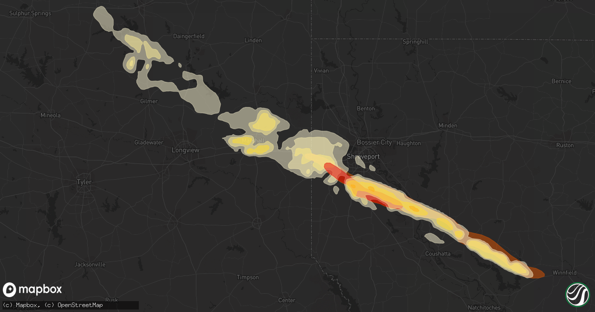
Hail Map in Waskom, TX on May 16, 2013
Get this storm
May 16 map
$229
one time, instant access
Download today. No call, no setup
Keep the $229
Bought the map and want the full workflow? Apply the entire $229 to a subscription within 7 days. None of it is wasted.
Every map, not just this one
This buys you this map. Subscription and you get every map we run, in the markets you choose from a few cities to whole states to nationwide. Plus real-time alerts the moment a storm fires.
Contact data
Name, contact info, occupancy, even credit band for addresses in the footprint. You go from where it hit to who to call.
Become the source they trust
Unlimited branding weather history reports on demand. You already have the documented answer ready for the property owner, and you are the one who showed up with it.
Property data and RoofTrace estimates
Pull up any address you have got, its value and the exact code rules for that jurisdiction, straight from One Click Code. Then RoofTrace estimates the squares, pitch, and roof value, priced the way you price.
Storm reports in Waskom, TX
Waskom, TX
| Date | Description |
|---|---|
| 05/16/20132:55 PM CDT | Numerous limbs down on i-20 |
| 05/16/20132:34 PM CDT | An ef-1 tornado touched down just south of i-20 sse of waskom and just west of magnolia road. Damage was caused to metal buildings and equipment at red diamond oilfield |
| 05/16/20132:30 PM CDT | *** 2 inj *** truck smashed by falling tree. Occupants rushed to hospital. |
| 05/16/20132:25 PM CDT | Numerous limbs down on i-20 |
| 05/16/20132:20 PM CDT | Large tree snapped 8 miles west of waskom |
| 05/16/20132:20 PM CDT | *** 1 inj *** an ef-1 tornado damaged several metal buildings at five star builders and uprooted and snapped trees along its path as it tracked east. Estimated peak win |
All States Impacted by Hail Map on May 16, 2013
All Cities Impacted by Hail Map on May 16, 2013
- Merriman, NE
- Van Alstyne, TX
- Sherman, TX
- Howe, TX
- Whitewright, TX
- Eckley, CO
- Wray, CO
- Pittsburg, TX
- Hayes Center, NE
- Rosalie, NE
- Walthill, NE
- Sloan, IA
- Whiting, IA
- Macy, NE
- Porcupine, SD
- Kyle, SD
- Shreveport, LA
- Waskom, TX
- Greenwood, LA
- Manilla, IA
- Denison, IA
- Saint Francis, KS
- Brewster, KS
- Anthon, IA
- Danbury, IA
- Correctionville, IA
- Battle Creek, IA
- Baileyville, ME
- Charter Oak, IA
- Saltillo, TX
- Calais, ME
- Waite, ME
- Utica, KS
- Dighton, KS
- Palisade, NE
- Ashland, LA
- Mooringsport, LA
- Frierson, LA
- Ringgold, LA
- Goldonna, LA
- De Berry, TX
- Coushatta, LA
- Hall Summit, LA
- Winnfield, LA
- Keithville, LA
- Stonewall, LA
- Marshall, TX
- Karnack, TX
- Elm Grove, LA
- Saline, LA
- Bethany, LA
- Washington, IN
- Hallsville, TX
- Yoder, WY
- Topsfield, ME
- Celina, TX
- Gunter, TX
- Winside, NE
- Hoskins, NE
- Culbertson, NE
- Mapleton, IA
- Ute, IA
- Soldier, IA
- Winslow, IN
- Otwell, IN
- Oconto, NE
- Broken Bow, NE
- El Dorado, AR
- Somerville, OH
- Wayne, NE
- Yuma, CO
- Whitesboro, TX
- Jefferson, TX
- Emerson, NE
- Ewing, NE
- Bartlett, NE
- Scroggins, TX
- Avinger, TX
- Mount Vernon, TX
- Mount Pleasant, TX
- Diana, TX
- Ore City, TX
- Lone Star, TX
- Leesburg, TX
- Gilmer, TX
- Harleton, TX
- Bassett, NE
- Dakota City, NE
- Homer, NE
- Winnebago, NE
- Haynesville, LA
- Junction City, AR
- Carroll, NE
- Julesburg, CO
- Meddybemps, ME
- Champion, NE
- Spearsville, LA
- Lillie, LA
- Summerfield, LA
- Grinnell, KS
- Italy, TX
- Grover, CO
- Lawton, IA
- Colby, KS
- Afton, IA
- La Grange, KY
- Gordon, NE
- Rushville, NE
- Dunlap, IA
- Woodbine, IA
- Dow City, IA
- Arion, IA
- Pine Ridge, SD
- Wakefield, NE
- Wheatland, WY
- Marion, LA
- Edson, KS
- Bird City, KS
- Oto, IA
- Danforth, ME
- Gove, KS
- Arnold, KS
- Quinter, KS
- Taylor, NE
- Haigler, NE
- Allen, SD
- Imperial, NE
- Le Mars, IA
- Merrill, IA
- Mount Holly, AR
- Oakley, KS
- Hoxie, KS
- Marietta, OK
- Mason City, NE
- Monroe City, IN
- Vincennes, IN
- Clearwater, NE
- Strong, AR
- Emerson, AR
- Farmerville, LA
- Huttig, AR
- Sulphur Bluff, TX
- Montgomery, IN
- Martin, SD
- Hazleton, IN
- Decatur, NE
- Levant, KS
- Denison, TX
- Saint Francisville, IL
- Carpenter, WY
- Cheyenne, WY
- Springfield, ME
- Newcastle, WY
- Hill City, SD
- Wilmington, OH
- Gurley, NE
- Trenton, TX
- Princeton, ME
- Laurel, NE
- Randolph, NE
- Guernsey, WY
- Xenia, OH
- Benkelman, NE
- Manning, IA
- Sadler, TX
- Shannon City, IA
- Elgin, NE
- Oglala, SD
- Colbert, OK
- Louisville, KY
- Taylorsville, KY
- Goodland, KS
- Osceola, IA
- Hubbard, NE
- Mount Washington, KY
- Batesland, SD
- Chappell, NE
- Holyoke, CO
- Wanblee, SD
- Custer, SD
- Moville, IA
- Kingsley, IA
- Hinton, IA
- Burns, WY
- Oakland City, IN
- Magnolia, AR
- Petersburg, IN
- Jasper, IN
- Burt, IA
- Algona, IA
- Neligh, NE
- Cherokee, IA
- Belden, NE
- Coleridge, NE
- Stanton, NE
- Ravenna, TX
- Bonham, TX
- Savoy, TX
- Pierce, NE
- Bells, TX
- Parks, NE
- Coxs Creek, KY
- Hornick, IA
- Defiance, IA
- Vail, IA
- Kingston, OK
- Carlisle, KY
- Allen, NE
- Francisco, IN
- Lingle, WY


