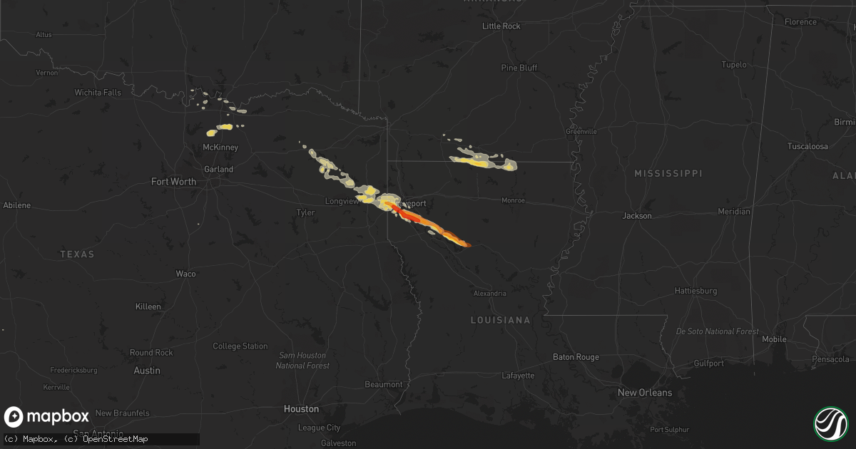
Hail Map on May 16, 2013
Get this storm
May 16 map
$229
one time, instant access
Download today. No call, no setup
Keep the $229
Bought the map and want the full workflow? Apply the entire $229 to a subscription within 7 days. None of it is wasted.
Every map, not just this one
This buys you this map. Subscription and you get every map we run, in the markets you choose from a few cities to whole states to nationwide. Plus real-time alerts the moment a storm fires.
Contact data
Name, contact info, occupancy, even credit band for addresses in the footprint. You go from where it hit to who to call.
Become the source they trust
Unlimited branding weather history reports on demand. You already have the documented answer ready for the property owner, and you are the one who showed up with it.
Property data and RoofTrace estimates
Pull up any address you have got, its value and the exact code rules for that jurisdiction, straight from One Click Code. Then RoofTrace estimates the squares, pitch, and roof value, priced the way you price.
States Impacted by Hail Map on May 16, 2013
Storm reports
Texas
| Date | Description |
|---|---|
| 05/16/20132:55 PM CDT | Numerous limbs down on i-20 |
| 05/16/20132:34 PM CDT | An ef-1 tornado touched down just south of i-20 sse of waskom and just west of magnolia road. Damage was caused to metal buildings and equipment at red diamond oilfield |
| 05/16/20132:30 PM CDT | *** 2 inj *** truck smashed by falling tree. Occupants rushed to hospital. |
| 05/16/20132:25 PM CDT | Numerous limbs down on i-20 |
| 05/16/20132:20 PM CDT | Large tree snapped 8 miles west of waskom |
| 05/16/20132:20 PM CDT | *** 1 inj *** an ef-1 tornado damaged several metal buildings at five star builders and uprooted and snapped trees along its path as it tracked east. Estimated peak win |
Kansas
| Date | Description |
|---|---|
| 05/16/20133:45 PM CDT | Also copious amounts of pea and marble sized hail covering the ground |
Colorado
| Date | Description |
|---|---|
| 05/16/20132:27 PM CDT | Nickel to quarter size hail in wray. |
| 05/16/20131:54 PM CDT | Delayed report from a cocorahs observer of three quarter inch to one inch in diameter hail. |
| 05/16/20131:50 PM CDT | A local report indicates 1.00 inch wind near 13 WNW WRAY |
| 05/16/20131:48 PM CDT | A local report indicates 1.00 inch wind near 4 NW WRAY |
| 05/16/20131:24 PM CDT | A local report indicates 1.75 inch wind near 2 N ECKLEY |
| 05/16/20131:10 PM CDT | A local report indicates 1.00 inch wind near 9 SE JULESBURG |
Louisiana
| Date | Description |
|---|---|
| 05/16/20134:45 PM CDT | A local report indicates 1.50 inch wind near 5 N CAMPTI |
| 05/16/20134:20 PM CDT | Trees down |
| 05/16/20133:54 PM CDT | Intersection of hwy 71 and hwy 4 |
| 05/16/20133:15 PM CDT | Hail damaged vehicles...trees down...power lines down |
| 05/16/20133:15 PM CDT | A local report indicates 1.50 inch wind near SHREVEPORT |
| 05/16/20133:13 PM CDT | Trees blocking half of road. |
| 05/16/20133:08 PM CDT | House had roof peeled back . Porch knocked off. |
| 05/16/20133:08 PM CDT | An ef-1 tornado broke several hardwood tree limbs along a short north to south path. Estimated peak wind...100 mph. Path length...0.25 miles. Path width...250 yards. |
| 05/16/20133:08 PM CDT | House had roof peeled back . Porch knocked off. |
| 05/16/20133:05 PM CDT | A local report indicates 1.00 inch wind near SHREVEPORT |
| 05/16/20133:04 PM CDT | A local report indicates 1.25 inch wind near 5 NNW STONEWALL |
| 05/16/20133:00 PM CDT | Heavy rain nickle size hail tree down |
| 05/16/20133:00 PM CDT | Heavy rain nickle size hail tree down |
| 05/16/20132:55 PM CDT | Hail covering the ground...a few trees down on shed..winds estimated at 70 mph. |
| 05/16/20132:55 PM CDT | Hail covering the ground...a few trees down on shed |
| 05/16/20132:40 PM CDT | Signs down on i-20 and sheds destroyed. |
| 05/16/20132:39 PM CDT | *** 1 inj *** an ef-1 tornado initially began just north of i-20 in greedwood near the old kelly truck stop. Trees were uprooted and snapped along the damage path. Seve |
| 05/16/20132:35 PM CDT | Semi blown on side. |
Wyoming
| Date | Description |
|---|---|
| 05/16/20132:11 PM CDT | A local report indicates 62 MPH wind near 5 NW RIVERTON |
| 05/16/20132:10 PM CDT | A local report indicates 62 MPH wind near 5 NW RIVERTON |
Maine
| Date | Description |
|---|---|
| 05/16/20132:57 PM CDT | A local report indicates 1.75 inch wind near CALAIS |
| 05/16/20132:57 PM CDT | A local report indicates 1.75 inch wind near COOPER |
| 05/16/20131:51 PM CDT | Half of hailstones quarter sized and half dime sized. Hail covering ground. |
Nebraska
| Date | Description |
|---|---|
| 05/16/20133:55 PM CDT | A local report indicates 59 MPH wind near 2 S KIMBALL |
| 05/16/20133:50 PM CDT | Several 6-8 inch diameter tree branches down in town. Also there was some dime sized hail for a couple minutes. |
| 05/16/20132:55 PM CDT | Hail is covering the ground with the largest stones being quarter sized. |
| 05/16/20132:53 PM CDT | Hail up to quarter size |
| 05/15/20137:55 PM CDT | Ground is covered with nickel to quarter size hail. |
Virginia
| Date | Description |
|---|---|
| 05/16/20135:10 PM CDT | Tree down on plainview lane |
| 05/16/20134:30 PM CDT | Tree down on taylors creek rd |
| 05/16/20133:31 PM CDT | Tree down on taylors creek rd |
| 05/16/20131:59 PM CDT | Tree down near 1000 block of owensville rd |
Arkansas
| Date | Description |
|---|---|
| 05/15/20137:15 PM CDT | Numerous trees down...power lines down...some structural damage...some county roads partially flooded |
Cities Impacted by Hail Map on May 16, 2013
- Merriman, NE
- Van Alstyne, TX
- Sherman, TX
- Howe, TX
- Whitewright, TX
- Eckley, CO
- Wray, CO
- Pittsburg, TX
- Hayes Center, NE
- Rosalie, NE
- Walthill, NE
- Sloan, IA
- Whiting, IA
- Macy, NE
- Porcupine, SD
- Kyle, SD
- Shreveport, LA
- Waskom, TX
- Greenwood, LA
- Manilla, IA
- Denison, IA
- Saint Francis, KS
- Brewster, KS
- Anthon, IA
- Danbury, IA
- Correctionville, IA
- Battle Creek, IA
- Baileyville, ME
- Charter Oak, IA
- Saltillo, TX
- Calais, ME
- Waite, ME
- Utica, KS
- Dighton, KS
- Palisade, NE
- Ashland, LA
- Mooringsport, LA
- Frierson, LA
- Ringgold, LA
- Goldonna, LA
- De Berry, TX
- Coushatta, LA
- Hall Summit, LA
- Winnfield, LA
- Keithville, LA
- Stonewall, LA
- Marshall, TX
- Karnack, TX
- Elm Grove, LA
- Saline, LA
- Bethany, LA
- Washington, IN
- Hallsville, TX
- Yoder, WY
- Topsfield, ME
- Celina, TX
- Gunter, TX
- Winside, NE
- Hoskins, NE
- Culbertson, NE
- Mapleton, IA
- Ute, IA
- Soldier, IA
- Winslow, IN
- Otwell, IN
- Oconto, NE
- Broken Bow, NE
- El Dorado, AR
- Somerville, OH
- Wayne, NE
- Yuma, CO
- Whitesboro, TX
- Jefferson, TX
- Emerson, NE
- Ewing, NE
- Bartlett, NE
- Scroggins, TX
- Avinger, TX
- Mount Vernon, TX
- Mount Pleasant, TX
- Diana, TX
- Ore City, TX
- Lone Star, TX
- Leesburg, TX
- Gilmer, TX
- Harleton, TX
- Bassett, NE
- Dakota City, NE
- Homer, NE
- Winnebago, NE
- Haynesville, LA
- Junction City, AR
- Carroll, NE
- Julesburg, CO
- Meddybemps, ME
- Champion, NE
- Spearsville, LA
- Lillie, LA
- Summerfield, LA
- Grinnell, KS
- Italy, TX
- Grover, CO
- Lawton, IA
- Colby, KS
- Afton, IA
- La Grange, KY
- Gordon, NE
- Rushville, NE
- Dunlap, IA
- Woodbine, IA
- Dow City, IA
- Arion, IA
- Pine Ridge, SD
- Wakefield, NE
- Wheatland, WY
- Marion, LA
- Edson, KS
- Bird City, KS
- Oto, IA
- Danforth, ME
- Gove, KS
- Arnold, KS
- Quinter, KS
- Taylor, NE
- Haigler, NE
- Allen, SD
- Imperial, NE
- Le Mars, IA
- Merrill, IA
- Mount Holly, AR
- Oakley, KS
- Hoxie, KS
- Marietta, OK
- Mason City, NE
- Monroe City, IN
- Vincennes, IN
- Clearwater, NE
- Strong, AR
- Emerson, AR
- Farmerville, LA
- Huttig, AR
- Sulphur Bluff, TX
- Montgomery, IN
- Martin, SD
- Hazleton, IN
- Decatur, NE
- Levant, KS
- Denison, TX
- Saint Francisville, IL
- Carpenter, WY
- Cheyenne, WY
- Springfield, ME
- Newcastle, WY
- Hill City, SD
- Wilmington, OH
- Gurley, NE
- Trenton, TX
- Princeton, ME
- Laurel, NE
- Randolph, NE
- Guernsey, WY
- Xenia, OH
- Benkelman, NE
- Manning, IA
- Sadler, TX
- Shannon City, IA
- Elgin, NE
- Oglala, SD
- Colbert, OK
- Louisville, KY
- Taylorsville, KY
- Goodland, KS
- Osceola, IA
- Hubbard, NE
- Mount Washington, KY
- Batesland, SD
- Chappell, NE
- Holyoke, CO
- Wanblee, SD
- Custer, SD
- Moville, IA
- Kingsley, IA
- Hinton, IA
- Burns, WY
- Oakland City, IN
- Magnolia, AR
- Petersburg, IN
- Jasper, IN
- Burt, IA
- Algona, IA
- Neligh, NE
- Cherokee, IA
- Belden, NE
- Coleridge, NE
- Stanton, NE
- Ravenna, TX
- Bonham, TX
- Savoy, TX
- Pierce, NE
- Bells, TX
- Parks, NE
- Coxs Creek, KY
- Hornick, IA
- Defiance, IA
- Vail, IA
- Kingston, OK
- Carlisle, KY
- Allen, NE
- Francisco, IN
- Lingle, WY