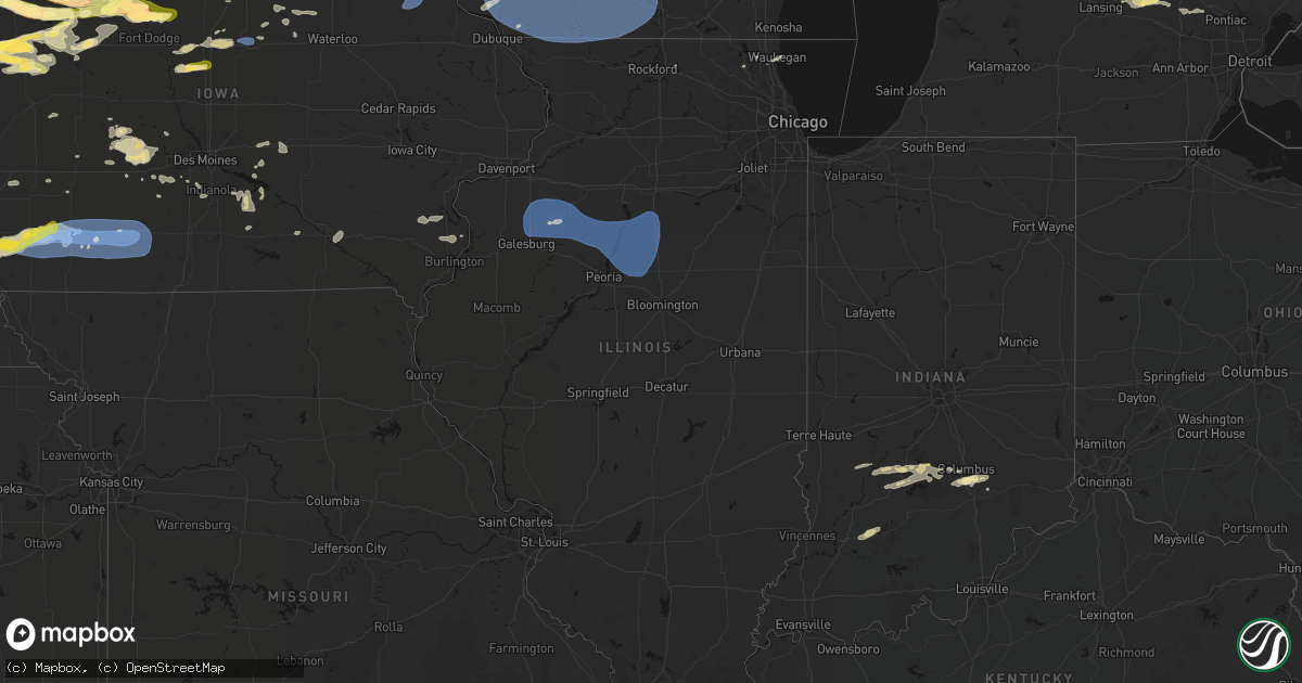
Hail Map in Illinois on May 15, 2026
Get this storm
May 15 map
$229
one time, instant access
Download today. No call, no setup
Keep the $229
Bought the map and want the full workflow? Apply the entire $229 to a subscription within 7 days. None of it is wasted.
Every map, not just this one
This buys you this map. Subscription and you get every map we run, in the markets you choose from a few cities to whole states to nationwide. Plus real-time alerts the moment a storm fires.
Contact data
Name, contact info, occupancy, even credit band for addresses in the footprint. You go from where it hit to who to call.
Become the source they trust
Unlimited branding weather history reports on demand. You already have the documented answer ready for the property owner, and you are the one who showed up with it.
Property data and RoofTrace estimates
Pull up any address you have got, its value and the exact code rules for that jurisdiction, straight from One Click Code. Then RoofTrace estimates the squares, pitch, and roof value, priced the way you price.
Storm reports in Illinois
Illinois
| Date | Description |
|---|---|
| 05/15/20265:25 AM CDT | Several large trees down across washburn. |
| 05/15/20265:10 AM CDT | 3 power poles down... And some damage to a nearby outbuilding. |
| 05/15/20265:09 AM CDT | Damage to an outbuilding... And a one hundred ft radio tower downed. |
| 05/15/20264:57 AM CDT | Tree limbs blown down. Relayed by media. |
| 05/15/20264:45 AM CDT | Several large tree limbs blown down. Power out. Time estimated from radar. |
All States Impacted by Hail Map on May 15, 2026
Cities Impacted by Hail Map on May 15, 2026
- Morton, TX
- Levelland, TX
- Milford, IA
- Estherville, IA
- Terril, IA
- Graettinger, IA
- Wallingford, IA
- Spirit Lake, IA
- Ringsted, IA
- Springfield, NE
- Louisville, NE
- South Bend, NE
- Dolliver, IA
- Armstrong, IA
- Lubbock, TX
- Shallowater, TX
- Murray, NE
- Plattsmouth, NE
- Hornick, IA
- Weeping Water, NE
- Sloan, IA
- Oto, IA
- Smithland, IA
- Nehawka, NE
- Gretna, NE
- Salix, IA
- Climbing Hill, IA
- Moville, IA
- Anthon, IA
- Union, NE
- Nebraska City, NE
- Danbury, IA
- Le Mars, IA
- Fairmont, MN
- Pacific Junction, IA
- Fenton, IA
- Swea City, IA
- Ledyard, IA
- Bancroft, IA
- Rolfe, IA
- Percival, IA
- Glenwood, IA
- Tabor, IA
- Malvern, IA
- Lone Rock, IA
- Titonka, IA
- Burt, IA
- Lakota, IA
- Ottosen, IA
- Bode, IA
- Randolph, IA
- Hastings, IA
- Jolley, IA
- Lytton, IA
- Nemaha, IA
- Storm Lake, IA
- Early, IA
- Thurman, IA
- Correctionville, IA
- Battle Creek, IA
- West Bend, IA
- Blue Earth, MN
- Granada, MN
- Elmwood, NE
- Elmore, MN
- Schaller, IA
- Cushing, IA
- Remsen, IA
- Oyens, IA
- Seminole, TX
- Seagraves, TX
- Denver City, TX
- Plains, TX
- Winnebago, MN
- Delavan, MN
- Idalou, TX
- Imogene, IA
- Emerson, IA
- Red Oak, IA
- Sidney, IA
- Granville, IA
- Marcus, IA
- Shickley, NE
- Wesley, IA
- Woden, IA
- Buffalo Center, IA
- Alta, IA
- Newell, IA
- Holstein, IA
- Paullina, IA
- Easton, MN
- Mapleton, MN
- Minnesota Lake, MN
- Elliott, IA
- Wells, MN
- Essex, IA
- Britt, IA
- Garner, IA
- Ida Grove, IA
- Clarinda, IA
- Villisca, IA
- Stanton, IA
- Strang, NE
- Bruning, NE
- Milligan, NE
- Tobias, NE
- Rockwell City, IA
- Pomeroy, IA
- Cleghorn, IA
- Primghar, IA
- Slaton, TX
- Forest City, IA
- Manson, IA
- Algona, IA
- Ohiowa, NE
- Childress, TX
- Corwith, IA
- Carleton, NE
- Albert City, IA
- Tahoka, TX
- Geary, OK
- Dickens, TX
- Kanawha, IA
- Sutherland, IA
- Sioux Rapids, IA
- Linn Grove, IA
- Royal, IA
- Peterson, IA
- Rembrandt, IA
- Nodaway, IA
- Corning, IA
- Gravity, IA
- Carbon, IA
- Lenox, IA
- New Richland, MN
- Waldorf, MN
- Ventura, IA
- Spur, TX
- Matador, TX
- Aurelia, IA
- Fonda, IA
- Pocahontas, IA
- Palmer, IA
- Crosbyton, TX
- Marathon, IA
- Lu Verne, IA
- Livermore, IA
- Goodell, IA
- Belmond, IA
- Thornton, IA
- Clear Lake, IA
- Cromwell, IA
- Sharpsburg, IA
- Clearfield, IA
- Creston, IA
- Diagonal, IA
- Prescott, IA
- Bridgewater, IA
- Shannon City, IA
- Post, TX
- Fluvanna, TX
- Justiceburg, TX
- Paducah, TX
- Gilmore City, IA
- Greenville, IA
- Spencer, IA
- Galva, IA
- Arthur, IA
- Havelock, IA
- Snyder, TX
- Odonnell, TX
- Dickens, IA
- Canute, OK
- Klemme, IA
- Quanah, TX
- Gail, TX
- Ceylon, MN
- Ruthven, IA
- Rockwell, IA
- Swaledale, IA
- Mason City, IA
- Crystal Lake, IA
- Afton, IA
- Tingley, IA
- Milford, NE
- Beaver Crossing, NE
- Larrabee, IA
- Calumet, IA
- Humboldt, IA
- Clare, IA
- Alexander, IA
- Meservey, IA
- Bradgate, IA
- Kiron, IA
- Friend, NE
- Girard, TX
- Badger, IA
- Odebolt, IA
- Davenport, NE
- Gould, OK
- Sheffield, IA
- Leland, IA
- Latimer, IA
- Cylinder, IA
- Whittemore, IA
- Emmetsburg, IA
- Rockford, IA
- Geneva, NE
- Dougherty, IA
- Thor, IA
- Dakota City, IA
- Rutland, IA
- Goldfield, IA
- Eagle Grove, IA
- Dorchester, NE
- Meriden, IA
- Cherokee, IA
- Sac City, IA
- Jayton, TX
- Bricelyn, MN
- Wall Lake, IA
- Marble Rock, IA
- Laurens, IA
- Joice, IA
- Lake Mills, IA
- Duke, OK
- Crete, NE
- Thompson, IA
- Vincent, IA
- Truesdale, IA
- Hardy, IA
- Renwick, IA
- Charles City, IA
- Varina, IA
- Rule, TX
- Herman, NE
- Tekamah, NE
- Duncombe, IA
- Alden, IA
- Blairsburg, IA
- Williams, IA
- Webster City, IA
- Haskell, TX
- Mondamin, IA
- Little Sioux, IA
- Pisgah, IA
- Minocqua, WI
- Tripoli, WI
- Fremont, NE
- Nickerson, NE
- Arlington, NE
- Ames, NE
- Cedar Bluffs, NE
- North Bend, NE
- Morse Bluff, NE
- Hooper, NE
- Bristow, IA
- Allison, IA
- Moorhead, IA
- Iowa Falls, IA
- Shell Rock, IA
- Blair, NE
- Clarksville, IA
- Modale, IA
- Malmo, NE
- Dumont, IA
- Ackley, IA
- Woodruff, WI
- Logan, IA
- Colon, NE
- Valley, NE
- Janesville, IA
- Waverly, IA
- Parkersburg, IA
- Aplington, IA
- Lake View, IA
- Missouri Valley, IA
- Eagle River, WI
- Yutan, NE
- Mead, NE
- Kennard, NE
- Bennington, NE
- Conover, WI
- Fort Calhoun, NE
- Elkhorn, NE
- Waterloo, NE
- Dike, IA
- Stout, IA
- Washington, NE
- Steamboat Rock, IA
- Strawberry Point, IA
- Volga, IA
- Elkader, IA
- Arlington, IA
- Manilla, IA
- Stratford, IA
- Omaha, NE
- Westside, IA
- Stanhope, IA
- Jewell, IA
- Neola, IA
- Underwood, IA
- Prairie Du Chien, WI
- Manning, IA
- Wauzeka, WI
- Woodman, WI
- Ellsworth, IA
- Minden, IA
- Hancock, IA
- Scranton, IA
- Coon Rapids, IA
- Bayard, IA
- Bagley, IA
- Prairie Du Sac, WI
- Mount Hope, WI
- Boscobel, WI
- Bagley, WI
- Bloomington, WI
- Patch Grove, WI
- Lancaster, WI
- Fennimore, WI
- Stitzer, WI
- Muscoda, WI
- Avoca, WI
- Highland, WI
- Montfort, WI
- Rewey, WI
- Livingston, WI
- Platteville, WI
- Cobb, WI
- Walnut, IA
- Guthrie Center, IA
- Potosi, WI
- Exira, IA
- Dodgeville, WI
- Belmont, WI
- Linden, WI
- Mineral Point, WI
- Spring Green, WI
- Lone Rock, WI
- Panora, IA
- Yale, IA
- Atlantic, IA
- Rio, WI
- Adair, IA
- Bouton, IA
- Cassville, WI
- Benton, WI
- Cuba City, WI
- Shullsburg, WI
- Darlington, WI
- Hazel Green, WI
- Dickeyville, WI
- Linden, IA
- Stuart, IA
- Menlo, IA
- Casey, IA
- Minburn, IA
- Perry, IA
- Hollandale, WI
- Argyle, WI
- Ridgeway, WI
- Blanchardville, WI
- Gratiot, WI
- Arena, WI
- Barneveld, WI
- Verona, WI
- Mount Horeb, WI
- New Glarus, WI
- Black Earth, WI
- Blue Mounds, WI
- Mazomanie, WI
- Belleville, WI
- Cross Plains, WI
- Redfield, IA
- Adel, IA
- Scales Mound, IL
- Apple River, IL
- South Wayne, WI
- Winslow, IL
- Dakota, IL
- Warren, IL
- Browntown, WI
- Monroe, WI
- Monticello, WI
- McConnell, IL
- Woodford, WI
- Orangeville, IL
- Dexter, IA
- Evansville, WI
- Rock City, IL
- South Beloit, IL
- Davis, IL
- Brooklyn, WI
- Juda, WI
- Orfordville, WI
- Beloit, WI
- Albany, WI
- Rockton, IL
- Durand, IL
- Brodhead, WI
- Madison, WI
- Oregon, WI
- Janesville, WI
- Mcfarland, WI
- Stoughton, WI
- Footville, WI
- Edgerton, WI
- Middleton, WI
- Afton, WI
- Van Meter, IA
- Earlham, IA
- Newton, IA
- Winterset, IA
- Campbellsport, WI
- Mayville, WI
- Brownsville, WI
- Lomira, WI
- Theresa, WI
- Monroe, IA
- Kellogg, IA
- Milo, IA
- Pleasantville, IA
- Prole, IA
- Cumming, IA
- Cascade, WI
- Belvidere, IL
- Grinnell, IA
- Lynnville, IA
- Lacona, IA
- Knoxville, IA
- Indianola, IA
- Swan, IA
- Otley, IA
- Peru, IA
- Melcher Dallas, IA
- Round Lake, IL
- Mchenry, IL
- Island Lake, IL
- Wauconda, IL
- Chariton, IA
- Columbia, IA
- Libertyville, IL
- Ottumwa, IA
- Grayslake, IL
- Russell, IA
- Waukegan, IL
- North Chicago, IL
- Agency, IA
- Eldon, IA
- Batavia, IA
- Winfield, IA
- Morning Sun, IA
- Wapello, IA
- Mediapolis, IA
- Yarmouth, IA
- Grand Rapids, MI
- Sperry, IA
- Albia, IA
- Lowell, MI
- Ada, MI
- Oakville, IA
- Belding, MI
- Orleans, MI
- Ionia, MI
- Saranac, MI
- Portland, MI
- Wataga, IL
- Woodhull, IL
- Lynn Center, IL
- Cambridge, IL
- Alpha, IL
- Rio, IL
- Galesburg, IL
- Henderson, IL
- Oneida, IL
- Galva, IL
- Altona, IL
- Kewanee, IL
- Toulon, IL
- Williamsfield, IL
- Knoxville, IL
- Victoria, IL
- Bishop Hill, IL
- La Fayette, IL
- Lyons, MI
- Muir, MI
- Pewamo, MI
- Westphalia, MI
- Speer, IL
- Princeville, IL
- Laura, IL
- Wyoming, IL
- Bradford, IL
- Saint Johns, MI
- Fowler, MI
- Dewitt, MI
- Eagle, MI
- Chillicothe, IL
- Sparland, IL
- Edelstein, IL
- Henry, IL
- Laingsburg, MI
- Bath, MI
- East Peoria, IL
- Lowpoint, IL
- Metamora, IL
- Washburn, IL
- Lacon, IL
- Solsberry, IN
- Bloomfield, IN
- Perry, MI
- Morrice, MI
- Bloomington, IN
- Williamston, MI
- Owosso, MI
- Haslett, MI
- Washington, IL
- Varna, IL
- Eureka, IL
- Roanoke, IL
- Minonk, IL
- Toluca, IL
- La Rose, IL
- Magnolia, IL
- Wenona, IL
- Lostant, IL
- Hennepin, IL
- Oglesby, IL
- Tonica, IL
- McNabb, IL
- Benson, IL
- Rutland, IL
- Streator, IL
- Dana, IL
- Secor, IL
- Fowlerville, MI
- Webberville, MI
- Byron, MI
- Bancroft, MI
- Freedom, IN
- Spencer, IN
- Coal City, IN
- Fenton, MI
- Worthington, IN
- Howell, MI
- Linden, MI
- Nashville, IN
- Columbus, IN
- Ellettsville, IN
- Unionville, IN
- Highland, MI
- Holly, MI
- Davisburg, MI
- White Lake, MI
- Seymour, IN
- Elizabethtown, IN
- Loogootee, IN
- Cannelburg, IN
- Scipio, IN
- North Vernon, IN
- Shoals, IN
- Grammer, IN
- Westport, IN
- Marquette, IA
- Monona, IA
- Farmersburg, IA
- Harpers Ferry, IA
- McGregor, IA


