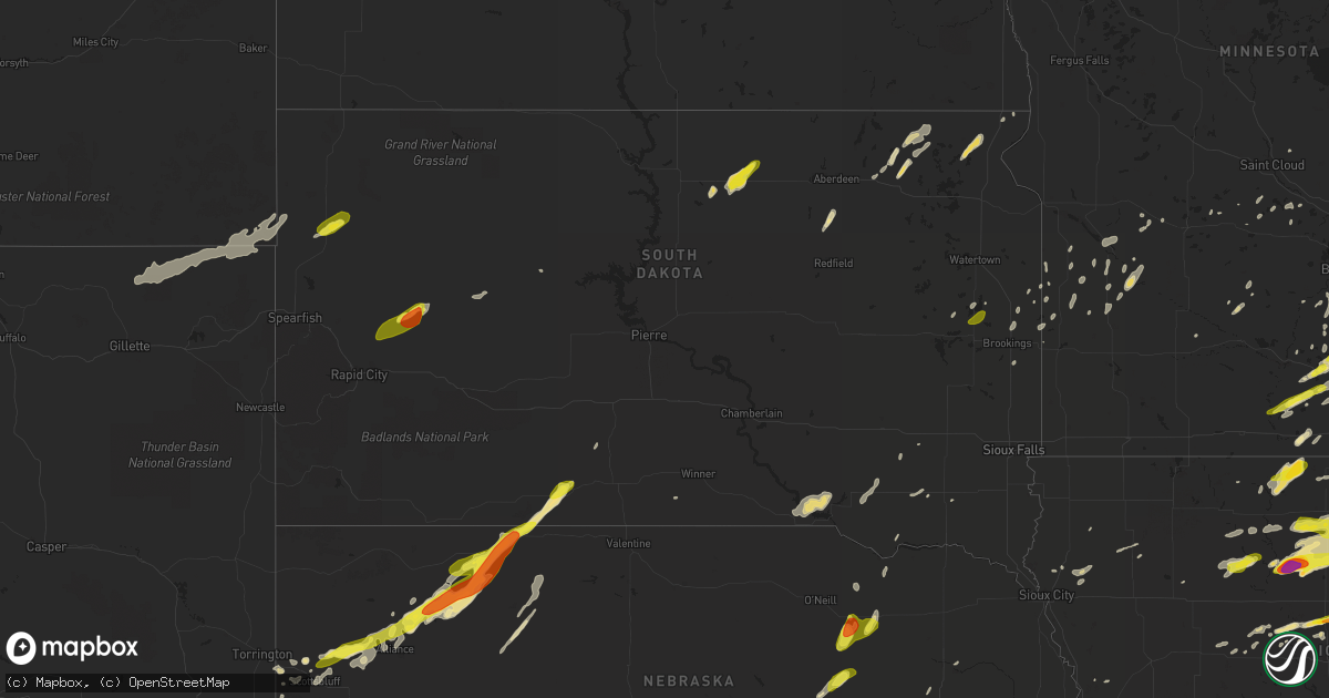
Hail Map in South Dakota on May 15, 2017
Get this storm
May 15 map
$229
one time, instant access
Download today. No call, no setup
Keep the $229
Bought the map and want the full workflow? Apply the entire $229 to a subscription within 7 days. None of it is wasted.
Every map, not just this one
This buys you this map. Subscription and you get every map we run, in the markets you choose from a few cities to whole states to nationwide. Plus real-time alerts the moment a storm fires.
Contact data
Name, contact info, occupancy, even credit band for addresses in the footprint. You go from where it hit to who to call.
Become the source they trust
Unlimited branding weather history reports on demand. You already have the documented answer ready for the property owner, and you are the one who showed up with it.
Property data and RoofTrace estimates
Pull up any address you have got, its value and the exact code rules for that jurisdiction, straight from One Click Code. Then RoofTrace estimates the squares, pitch, and roof value, priced the way you price.
Storm reports in South Dakota
South Dakota
| Date | Description |
|---|---|
| 05/15/20178:30 AM CDT | Sdsu mesonet station. |
| 05/15/20178:30 AM CDT | 8 inch diameter tree branches down. |
| 05/15/20178:05 AM CDT | *** 1 inj *** semi truck blown off the road. |
| 05/15/20178:05 AM CDT | Shingles off roofs... Some building damage. |
| 05/15/20175:02 AM CDT | A local report indicates 1.00 inch wind near PIERPONT |
| 05/15/20172:35 AM CDT | A local report indicates 1.00 inch wind near 2 SSE STONE BRIDGE |
| 05/15/20172:00 AM CDT | About an inch of rain. |
| 05/14/201711:00 PM CDT | Hail ranged from 1/4 to 1. A few leaves on the trees were shredded from the hail. |
All States Impacted by Hail Map on May 15, 2017
Cities Impacted by Hail Map on May 15, 2017
- Mitchell, NE
- Harrison, NE
- Adell, WI
- Geneva, IA
- Alexander, IA
- Dumont, IA
- Hampton, IA
- Aredale, IA
- Humboldt, IA
- Coulter, IA
- Clarion, IA
- Sheffield, IA
- Goldfield, IA
- Kanawha, IA
- Belmond, IA
- Hardy, IA
- Rowan, IA
- Eagle Grove, IA
- Latimer, IA
- Thor, IA
- Dows, IA
- New Prague, MN
- Webster, MN
- Hampton, MN
- Farmington, MN
- Kanorado, KS
- Burnsville, MN
- Savage, MN
- Norton, KS
- Pecatonica, IL
- Ridott, IL
- Aurora, SD
- White, SD
- Brookings, SD
- Rexford, KS
- Farnam, NE
- Readstown, WI
- La Farge, WI
- Viola, WI
- Hillsboro, WI
- Scott City, KS
- Saint Paul, MN
- Minneapolis, MN
- Boyd, MN
- Fowler, KS
- Meade, KS
- Tripp, SD
- Wagner, SD
- Parkston, SD
- Delmont, SD
- Gillette, WY
- Lyman, NE
- Morrill, NE
- Plainview, MN
- Butternut, WI
- Saint Francis, KS
- Buffalo Center, IA
- Grove City, MN
- Cresco, IA
- Calmar, IA
- Elma, IA
- Ridgeway, IA
- Byron, MN
- Rochester, MN
- Cheyenne Wells, CO
- Arapahoe, CO
- Clinton, WI
- Stratford, TX
- Machesney Park, IL
- Loves Park, IL
- Rockford, IL
- Langford, SD
- Bladen, NE
- Roseland, NE
- Ayr, NE
- Waterford, WI
- Waseca, MN
- Winona, KS
- Colby, KS
- Monument, KS
- Oakley, KS
- Ossian, IA
- Luana, IA
- Hawkeye, IA
- Decorah, IA
- Sumner, IA
- Bristow, IA
- Plainfield, IA
- New Hampton, IA
- Ionia, IA
- Dakota City, IA
- Britt, IA
- Postville, IA
- Woodman, WI
- Elkader, IA
- Fredericksburg, IA
- Prairie Du Chien, WI
- Mason City, IA
- Corwith, IA
- Mount Hope, WI
- Frederika, IA
- Alta Vista, IA
- Greene, IA
- Garnavillo, IA
- Waucoma, IA
- West Union, IA
- Charles City, IA
- Shell Rock, IA
- Clarksville, IA
- Patch Grove, WI
- Goodell, IA
- Renwick, IA
- Protivin, IA
- Clermont, IA
- Dougherty, IA
- Riceville, IA
- Bagley, WI
- Monona, IA
- Fort Atkinson, IA
- McGregor, IA
- Bloomington, WI
- Garner, IA
- Volga, IA
- Chapin, IA
- Meservey, IA
- Rockwell, IA
- Waverly, IA
- Nashua, IA
- Klemme, IA
- Osage, IA
- Saint Lucas, IA
- Floyd, IA
- Clear Lake, IA
- Saint Olaf, IA
- Marble Rock, IA
- Nora Springs, IA
- Allison, IA
- Orchard, IA
- Thornton, IA
- Farmersburg, IA
- Tripoli, IA
- Elgin, IA
- Harpers Ferry, IA
- Rockford, IA
- Spillville, IA
- Marquette, IA
- Castalia, IA
- Lawler, IA
- Rudd, IA
- Swaledale, IA
- West Bend, IA
- North Prairie, WI
- Mukwonago, WI
- Hendricks, MN
- Goodland, KS
- Sharon Springs, KS
- Venango, NE
- Champion, NE
- Northville, SD
- Mellette, SD
- Rockton, IL
- Durand, IL
- Winnebago, IL
- Paxton, NE
- Milwaukee, WI
- Cedarburg, WI
- North Freedom, WI
- Baraboo, WI
- Roberts, WI
- Owatonna, MN
- Hayes Center, NE
- Guymon, OK
- Portage, WI
- Stinnett, TX
- Morse, TX
- Pine Island, MN
- West Concord, MN
- Houston, MN
- Caledonia, MN
- Mchenry, IL
- Ringwood, IL
- Wonder Lake, IL
- Hooker, OK
- Union Center, SD
- Enning, SD
- Palisade, NE
- Wood Lake, MN
- Hanley Falls, MN
- Granite Falls, MN
- Circle Pines, MN
- Hugo, MN
- Flandreau, SD
- Goodwell, OK
- Texhoma, OK
- Otter, MT
- Decker, MT
- Faribault, MN
- Welch, MN
- New Richmond, WI
- Hammond, WI
- Bay City, WI
- Alma, NE
- Republican City, NE
- Osseo, MN
- Maple Grove, MN
- Ingleside, IL
- Ellsworth, IA
- Stanhope, IA
- Jewell, IA
- Stratford, IA
- Newcastle, WY
- Claremont, MN
- Hulett, WY
- Moorcroft, WY
- Holdrege, NE
- Badger, IA
- Rolla, KS
- Lake Andes, SD
- Fairfax, SD
- Geddes, SD
- Le Mars, IA
- Hinton, IA
- Kingsley, IA
- Remsen, IA
- Soldiers Grove, WI
- Valentine, NE
- Alliance, NE
- Mercer, WI
- Gordon, NE
- Panhandle, TX
- Orleans, NE
- Alzada, MT
- Rushville, NE
- Ellsworth, NE
- Lanesboro, MN
- Peterson, MN
- Gowrie, IA
- Harcourt, IA
- Paton, IA
- Medford, MN
- Morristown, MN
- Janesville, MN
- Bricelyn, MN
- Wells, MN
- Parmelee, SD
- Tuthill, SD
- Kimball, MN
- Saint Charles, MN
- Chatfield, MN
- Stewartville, MN
- Wykoff, MN
- Spring Valley, MN
- Dover, MN
- Wallace, KS
- Dumas, TX
- Channing, TX
- Jefferson, WI
- Lakin, KS
- Ulysses, KS
- Texhoma, TX
- Dawson, MN
- Madison, MN
- Johnson, KS
- Harmony, MN
- Canton, MN
- Richfield, KS
- Glidden, WI
- Maynard, MN
- Millville, MN
- Zumbro Falls, MN
- Lake City, MN
- Lancaster, WI
- Fennimore, WI
- Grafton, WI
- Watkins, MN
- Ivanhoe, MN
- Porter, MN
- Tribune, KS
- Grant, NE
- Wray, CO
- Haigler, NE
- Parks, NE
- Belle Fourche, SD
- Elgin, MN
- Eyota, MN
- Eads, CO
- Veteran, WY
- Yoder, WY
- Torrington, WY
- Kenyon, MN
- Walworth, WI
- Harvard, IL
- Merriman, NE
- Howes, SD
- Windsor, WI
- Waunakee, WI
- Sun Prairie, WI
- Dane, WI
- Deforest, WI
- Winner, SD
- Waterloo, WI
- Wisconsin Dells, WI
- Titonka, IA
- Bancroft, IA
- Lakota, IA
- Story City, IA
- Shawnee, WY
- Brewster, KS
- Edson, KS
- Marienthal, KS
- Deerfield, KS
- Leoti, KS
- Orchard, NE
- Clearwater, NE
- Royal, NE
- Britton, SD
- Wheatland, WY
- Erwin, SD
- Mequon, WI
- Winona, MN
- Glendive, MT
- Emery, SD
- Mayville, WI
- Marshall, MN
- Cottonwood, MN
- Weston, WY
- Bethel, MN
- Andover, MN
- Cedar, MN
- Wyoming, MN
- Stacy, MN
- Gruver, TX
- Livingston, WI
- Rewey, WI
- Platteville, WI
- Bingham, NE
- Hay Springs, NE
- Lannon, WI
- Sussex, WI
- Menomonee Falls, WI
- Grand Meadow, MN
- Claremont, SD
- Sunray, TX
- Masterson, TX
- Spearman, TX
- Amarillo, TX
- Fritch, TX
- La Crescent, MN
- Stoddard, WI
- Brownsville, MN
- Preston, MN
- Coon Valley, WI
- La Crosse, WI
- Hokah, MN
- Fountain, MN
- Chaseburg, WI
- Lewiston, MN
- Rushford, MN
- Utica, MN
- Frost, MN
- Blue Earth, MN
- Edison, NE
- Ewing, NE
- Morrisonville, WI
- Madison, WI
- Marshall, WI
- Arlington, WI
- New Underwood, SD
- East Troy, WI
- Naponee, NE
- Phillipsburg, KS
- Ogden, IA
- Fairmount, ND
- Selden, KS
- Oberlin, KS
- Dresden, KS
- Jennings, KS
- Hugoton, KS
- Tyrone, OK
- Liberal, KS
- Turpin, OK
- Agra, KS
- Perryton, TX
- Burns, WY
- Cheyenne, WY
- Plymouth, IA
- Pilot Mound, IA
- Galena, IL
- Claude, TX
- Groom, TX
- Fort Atkinson, WI
- Sullivan, WI
- Helenville, WI
- Cannon Falls, MN
- Dayton, IA
- Kit Carson, CO
- Montgomery, MN
- Kilkenny, MN
- Andover, SD
- Pierpont, SD
- Borger, TX
- Skellytown, TX
- Hopkins, MN
- Riverton, NE
- Franklin, NE
- Cozad, NE
- Minden, NE
- Elroy, WI
- Kendall, WI
- Mauston, WI
- Wonewoc, WI
- Pocahontas, IA
- Gilmore City, IA
- Rutland, IA
- Bradgate, IA
- Palmer, IA
- Prairie Du Sac, WI
- Mazomanie, WI
- Lodi, WI
- Columbus, WI
- Sauk City, WI
- Vega, TX
- Fallon, MT
- Iowa Falls, IA
- Lake Elmo, MN
- McCook, NE
- Lone Rock, WI
- Richland Center, WI
- Clay Center, NE
- Beloit, WI
- Janesville, WI
- Avalon, WI
- Sisseton, SD
- Eden, SD
- Hartland, MN
- Annandale, MN
- Mansfield, SD
- Mapleton, MN
- Merrimac, WI
- Gibbon, MN
- Wellington, CO
- Arthur, NE
- Le Center, MN
- Dorchester, IA
- Waukon, IA
- Amboy, MN
- Minnesota Lake, MN
- Rollingstone, MN
- Wilcox, NE
- Hildreth, NE
- Axtell, NE
- Kensington, KS
- Belvidere, IL
- Roscoe, IL
- Caledonia, IL
- Shirland, IL
- Davis, IL
- Brodhead, WI
- Lakeville, MN
- White River, SD
- Lansing, IA
- Campbell, NE
- Hayfield, MN
- Brownton, MN
- Long Island, KS
- Stamford, NE
- Lenora, KS
- Beaver City, NE
- Logan, KS
- Oxford, NE
- Prairie View, KS
- Almena, KS
- Hendley, NE
- Estelline, SD
- Minneota, MN
- Taunton, MN
- Canby, MN
- Plains, KS
- Verona, WI
- Belleville, WI
- Oregon, WI
- Merrill, IA
- Stoughton, WI
- Edgerton, WI
- Poynette, WI
- Clarkfield, MN
- Edgewood, IA
- Hoven, SD
- Bowdle, SD
- Mantorville, MN
- Burt, IA
- Gary, SD
- Cottage Grove, MN
- Hastings, MN
- Afton, MN
- Rio, WI
- Foley, MN
- Sauk Rapids, MN
- South Haven, MN
- Dassel, MN
- Waterville, MN
- Broken Bow, NE
- Mineral Point, WI
- Hastings, NE
- Groton, SD
- Dupree, SD
- Grafton, IA
- Manly, IA
- Kensett, IA
- Churdan, IA
- High Bridge, WI
- Mabel, MN
- Elmwood, WI
- Watson, MN
- Kismet, KS
- Dickinson, ND
- Beaver Dam, WI
- Fall River, WI
- Plain, WI
- Spring Green, WI
- Lagrange, WY
- Hyannis, NE
- Cambridge, WI
- Montevideo, MN
- Watertown, WI
- Glenvil, NE
- Westby, WI
- Cherokee, IA
- Lombard, IL
- Glendale Heights, IL
- Glen Ellyn, IL
- Sheridan Lake, CO
- Hollandale, WI
- Barneveld, WI
- Blue Mounds, WI
- Upson, WI
- Cleveland, MN
- Rosholt, SD
- Park Falls, WI
- Roscoe, SD
- Hosmer, SD
- Clayton, KS
- Norcatur, KS
- Germantown, WI
- Richfield, WI
- Jackson, WI
- Lance Creek, WY
- Marietta, MN
- Edgar, NE
- Sutton, NE
- Tomah, WI
- Imperial, NE
- Murdock, MN
- Capron, IL
- Garden Prairie, IL
- Glidden, IA
- Scranton, IA
- Randalia, IA
- Oronoco, MN
- Altura, MN
- Upton, WY
- Sacred Heart, MN
- Lonsdale, MN
- Idalia, CO
- Belle Plaine, MN
- Stockholm, WI
- Hudson, WI
- Larrabee, IA
- Bloomington, NE
- Bartlett, NE
- Comstock, NE
- Deerfield, WI
- Cottage Grove, WI
- Grinnell, KS
- Kasson, MN
- Morgan, MN
- Sheridan, WY
- New Richland, MN
- Alden, MN
- Freeborn, MN
- Ellendale, MN
- Hawk Springs, WY
- White Deer, TX
- Maywood, NE
- Boone, IA
- Blue River, WI
- Gays Mills, WI
- Muscoda, WI
- Dousman, WI
- Eagle, WI
- South Haven, MI
- Ringsted, IA
- Rolfe, IA
- Pomeroy, IA
- Wyocena, WI
- Pardeeville, WI
- Spearville, KS
- Wright, KS
- Benkelman, NE
- Gibbon, NE
- Dundas, MN
- La Valle, WI
- Lyndon Station, WI
- Stanton, NE
- Norfolk, NE
- Waldorf, MN
- Mankato, MN
- Nerstrand, MN
- Delavan, MN
- Zumbrota, MN
- Dodge Center, MN
- Winnebago, MN
- Wanamingo, MN
- Pemberton, MN
- Ericson, NE
- Burlington, CO
- Coloma, MI
- Watervliet, MI
- Hartford, MI
- Malone, WI
- Fond Du Lac, WI
- Wauneta, NE
- Hoxie, KS
- Winthrop, MN
- Mazeppa, MN
- Cable, WI
- Lake City, SD
- Elko New Market, MN
- Colwell, IA
- Menno, SD
- Monroe, WI
- Juda, WI
- Neosho, WI
- Astoria, SD
- Wilsonville, NE
- Radcliffe, IA
- Forest City, IA
- Thompson, IA
- Leland, IA
- New Effington, SD
- Dalton, WI
- Lake Benton, MN
- Saronville, NE
- Inavale, NE
- Prior Lake, MN
- Bode, IA
- Lu Verne, IA
- Carr, CO
- Montfort, WI
- Stitzer, WI
- Herndon, KS
- Bird City, KS
- Blooming Prairie, MN
- Atwater, MN
- Verdigre, NE
- Blue Hill, NE
- Fairfield, NE
- Lawrence, NE
- Nelson, NE
- Deweese, NE
- Inver Grove Heights, MN
- South Saint Paul, MN
- Houlton, WI
- Bayport, MN
- Newport, MN
- Stillwater, MN
- Somerset, WI
- Saint Paul Park, MN
- Goodhue, MN
- Covert, MI
- Monticello, WI
- Jefferson, IA
- Levant, KS
- Platte, SD
- Bonesteel, SD
- Olivet, SD
- Palmyra, WI
- Cody, NE
- Whitman, NE
- Funk, NE
- Albert Lea, MN
- Spalding, NE
- Fe Warren Afb, WY
- Tyndall, SD
- Springfield, SD
- Mallard, IA
- South Beloit, IL
- Darien, WI
- Sharon, WI
- Randolph, MN
- Northfield, MN
- Durango, IA
- Dubuque, IA
- Sherrill, IA
- Oconomowoc, WI
- Ixonia, WI
- Waukesha, WI
- Hartland, WI
- Brandt, SD
- Wildorado, TX
- Jordan, MN
- Buffalo, MN
- Maple Lake, MN
- Sparta, WI
- Niobrara, NE
- Guide Rock, NE
- Eastman, WI
- East Dubuque, IL
- Hazel Green, WI
- Cassville, WI
- Garber, IA
- Glen Haven, WI
- Guttenberg, IA
- Woodbine, IA
- Moorhead, IA
- Dunlap, IA
- Mellen, WI
- Hubertus, WI
- Colgate, WI
- Kerkhoven, MN
- Kasota, MN
- Spring Valley, WI
- Knapp, WI
- Menomonie, WI
- Meriden, WY
- Alton, IA
- Weskan, KS
- Freeport, IL
- Eden Prairie, MN
- Storm Lake, IA
- Lake Norden, SD
- Arlington, SD
- Darwin, MN
- Oak, NE
- Mcfarland, WI
- Ethan, SD
- Burnett, WI
- Lefor, ND
- New England, ND
- Holstein, NE
- Madrid, NE
- Minatare, NE
- Gering, NE
- Scottsbluff, NE
- Hemingford, NE
- Bayard, NE
- Osage, WY
- Viborg, SD
- Bethune, CO
- Dayton, MN
- Anoka, MN
- Meriden, IA
- Cleghorn, IA
- Albany, WI
- Beldenville, WI
- Ellsworth, WI
- Albin, WY
- Madison, NE
- Onawa, IA
- Racine, MN
- Stewart, MN
- Kellogg, MN
- Marine On Saint Croix, MN
- Forest Lake, MN
- Chisago City, MN
- Scandia, MN
- Toronto, SD
- Cashton, WI
- Norwalk, WI
- Monticello, MN
- Wallace, NE
- Booker, TX
- Balko, OK
- Atlanta, NE
- Elgin, NE
- Poplar Grove, IL
- Clearmont, WY
- Recluse, WY
- Olive, MT
- Volborg, MT
- Broadus, MT
- Newell, SD
- Sturgis, SD
- Martin, SD
- Bruce, SD


