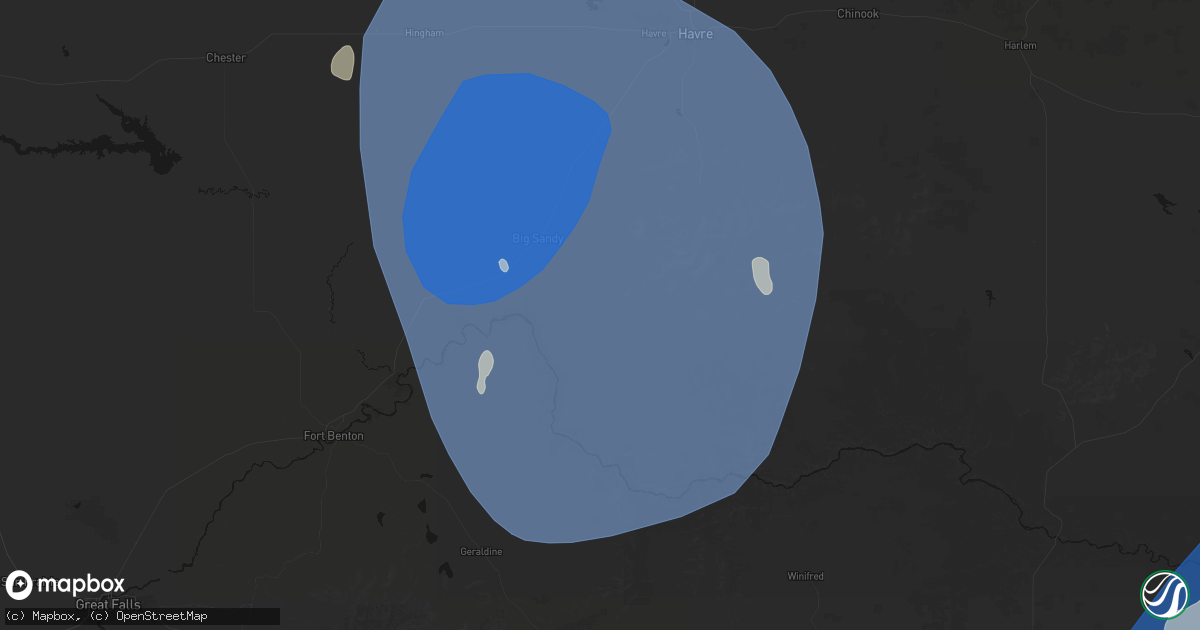
Hail Map in Big Sandy, MT on May 13, 2026
Get this storm
May 13 map
$229
one time, instant access
Download today. No call, no setup
Keep the $229
Bought the map and want the full workflow? Apply the entire $229 to a subscription within 7 days. None of it is wasted.
Every map, not just this one
This buys you this map. Subscription and you get every map we run, in the markets you choose from a few cities to whole states to nationwide. Plus real-time alerts the moment a storm fires.
Contact data
Name, contact info, occupancy, even credit band for addresses in the footprint. You go from where it hit to who to call.
Become the source they trust
Unlimited branding weather history reports on demand. You already have the documented answer ready for the property owner, and you are the one who showed up with it.
Property data and RoofTrace estimates
Pull up any address you have got, its value and the exact code rules for that jurisdiction, straight from One Click Code. Then RoofTrace estimates the squares, pitch, and roof value, priced the way you price.
Storm reports in Big Sandy, MT
Big Sandy, MT
| Date | Description |
|---|---|
| 05/13/20266:59 PM CDT | Ambient weather station: 2flagsweather. |
| 05/13/20265:20 PM CDT | Big sandy nw montana mesonet measured a 85 mph wind gust. |
| 05/13/20265:00 PM CDT | Corrects previous tstm wnd gst report from 11 sse big sandy. Montana mesonet big sandy se. |
| 05/13/20265:00 PM CDT | [landspout] delayed report. High quality video of dust-wrapped circulation in contact with the ground ahead of destructive thunderstorm outflow containing significant |
| 05/12/20267:00 PM CDT | Montana mesonet big sandy se. |
All States Impacted by Hail Map on May 13, 2026
All Cities Impacted by Hail Map on May 13, 2026
- Franklin, PA
- Seneca, PA
- Oil City, PA
- Saint Clairsville, OH
- Franklinville, NY
- Martins Ferry, OH
- Dillonvale, OH
- Adena, OH
- Venus, PA
- Cranberry, PA
- Avella, PA
- Lewis Run, PA
- Hickory, PA
- Washington, PA
- Gifford, PA
- Cyclone, PA
- New Martinsville, WV
- Canonsburg, PA
- Houston, PA
- Eighty Four, PA
- Sistersville, WV
- Venetia, PA
- Ridgway, PA
- Proctor, WV
- Finleyville, PA
- Littleton, WV
- Brockway, PA
- Middlebourne, WV
- Metz, WV
- Mannington, WV
- Burton, WV
- Jacksonburg, WV
- Monongahela, PA
- Donora, PA
- Wana, WV
- Fairview, WV
- Belle Vernon, PA
- West Newton, PA
- Farmington, WV
- Webster, PA
- Smithton, PA
- Yukon, PA
- Waterloo, NY
- New Stanton, PA
- Bentleyville, PA
- West Union, WV
- Pullman, WV
- Ruffs Dale, PA
- Wyano, PA
- Lyons, NY
- Sodus, NY
- Rivesville, WV
- Morgantown, WV
- Hunker, PA
- Maidsville, WV
- New Milton, WV
- Troy, WV
- Camden, WV
- Weston, WV
- Alum Bridge, WV
- Coxs Mills, WV
- Auburn, WV
- Berea, WV
- Acme, PA
- Austin, PA
- Savannah, NY
- Fairmont, WV
- Clyde, NY
- Millstone, WV
- Orma, WV
- Arnoldsburg, WV
- Latrobe, PA
- Smithville, WV
- Stahlstown, PA
- Ligonier, PA
- Strabane, PA
- Marianna, PA
- Daisytown, PA
- Beallsville, PA
- Brownsville, PA
- Scenery Hill, PA
- Richeyville, PA
- Fredericktown, PA
- Jane Lew, WV
- Lost Creek, WV
- Greensburg, PA
- Mount Pleasant, PA
- Ireland, WV
- Napier, WV
- Geraldine, MT
- Fort Benton, MT
- Chinook, MT
- Rudyard, MT
- Denton, MT
- Winifred, MT
- Hingham, MT
- Havre, MT
- Lloyd, MT
- Loma, MT
- Box Elder, MT
- Big Sandy, MT
- Gildford, MT
- Kremlin, MT
- Shelley, ID
- Firth, ID
- Blackfoot, ID
- Idaho Falls, ID
- Pingree, ID
- Rigby, ID
- Ririe, ID
- Iona, ID
- Basalt, ID
- Romney, WV
- Slanesville, WV
- Green Spring, WV
- Points, WV
- Levels, WV
- Springfield, WV
- Paw Paw, WV
- Great Cacapon, WV
- Oldtown, MD
- Augusta, WV
- Winchester, VA
- Bunker Hill, WV
- Gore, VA
- Bloomery, WV
- Inwood, WV
- Berkeley Springs, WV
- Cross Junction, VA
- Capon Bridge, WV
- High View, WV
- Glengary, WV
- Hedgesville, WV
- Gerrardstown, WV
- Clear Brook, VA
- Yellow Spring, WV
- Williamsville, VA
- Winnett, MT
- Grass Range, MT
- Deerfield, VA
- Millboro, VA
- Roy, MT
- Brusett, MT
- Jordan, MT
- Malta, MT
- Zortman, MT
- Fort Peck, MT
- Hinsdale, MT
- Glasgow, MT
- Herminie, PA
- Madison, PA
- Clarington, PA
- Marienville, PA
- Kingwood, WV


