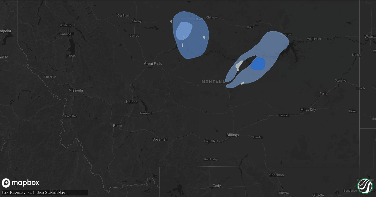
Hail Map in Montana on May 13, 2026
Get this storm
May 13 map
$229
one time, instant access
Download today. No call, no setup
Keep the $229
Bought the map and want the full workflow? Apply the entire $229 to a subscription within 7 days. None of it is wasted.
Every map, not just this one
This buys you this map. Subscription and you get every map we run, in the markets you choose from a few cities to whole states to nationwide. Plus real-time alerts the moment a storm fires.
Contact data
Name, contact info, occupancy, even credit band for addresses in the footprint. You go from where it hit to who to call.
Become the source they trust
Unlimited branding weather history reports on demand. You already have the documented answer ready for the property owner, and you are the one who showed up with it.
Property data and RoofTrace estimates
Pull up any address you have got, its value and the exact code rules for that jurisdiction, straight from One Click Code. Then RoofTrace estimates the squares, pitch, and roof value, priced the way you price.
Storm reports in Montana
Montana
| Date | Description |
|---|---|
| 05/13/20266:59 PM CDT | Ambient weather station: 2flagsweather. |
| 05/13/20266:55 PM CDT | Awos station k00u 2 wnw hardin. |
| 05/13/20266:55 PM CDT | Winnett sw station |
| 05/13/20266:53 PM CDT | Asos station klvm livingston. |
| 05/13/20266:45 PM CDT | A local report indicates 65 MPH wind near 1 SE Busby |
| 05/13/20266:45 PM CDT | Mesonet station beacon hill us 87 mp 35 |
| 05/13/20266:40 PM CDT | Mesonet station dw8455 livingston. |
| 05/13/20266:15 PM CDT | Mesonet station mtchk chinook us-2 mp 403.5. |
| 05/13/20266:05 PM CDT | A local report indicates 62 MPH wind near 7 N Lavina |
| 05/13/20265:53 PM CDT | Trained spotter reported a 62 mph wind gust. |
| 05/13/20265:50 PM CDT | A local report indicates 80 MPH wind near 7 W Lodge Grass |
| 05/13/20265:46 PM CDT | Asos station khvr havre airport. |
| 05/13/20265:45 PM CDT | Mesonet station mtm06 arc-n havre. |
| 05/13/20265:45 PM CDT | Mesonet station dvi02964 havre. |
| 05/13/20265:45 PM CDT | Mesonet station gw6393 kremlin 3ese. |
| 05/13/20265:45 PM CDT | Mesonet station gw0416 joplin. |
| 05/13/20265:40 PM CDT | Mesonet station gw6390 gildford 6se. |
| 05/13/20265:35 PM CDT | Mesonet station dbym8 derby mountain. |
| 05/13/20265:31 PM CDT | Mesonet station mthls harlowton south us-191 mp 22.0. |
| 05/13/20265:30 PM CDT | Mesonet station mtinv inverness |
| 05/13/20265:30 PM CDT | Mesonet station dw4821 chester. |
| 05/13/20265:30 PM CDT | Mesonet station ew1931 rudyard. |
| 05/13/20265:30 PM CDT | Mesonet station gw3530 rudyard eleven south. |
| 05/13/20265:30 PM CDT | Mesonet station gw4079 inverness ten south southeast. |
| 05/13/20265:20 PM CDT | Big sandy nw montana mesonet measured a 85 mph wind gust. |
| 05/13/20265:15 PM CDT | Mesonet station gw4015 chester four ne. |
| 05/13/20265:15 PM CDT | Mesonet station gw6710 meadowlane. |
| 05/13/20265:15 PM CDT | Awos station k6s0 big timber. |
| 05/13/20265:00 PM CDT | Mesonet station gw3478 tctiber. |
| 05/13/20265:00 PM CDT | Corrects previous tstm wnd gst report from 11 sse big sandy. Montana mesonet big sandy se. |
| 05/13/20265:00 PM CDT | [landspout] delayed report. High quality video of dust-wrapped circulation in contact with the ground ahead of destructive thunderstorm outflow containing significant |
| 05/13/20265:00 PM CDT | Mesonet station gw3487 tiber dam six east. |
| 05/13/20265:00 PM CDT | Mesonet station mtlrh livingston river hill. |
| 05/13/20265:00 PM CDT | Mesonet station gw4098 tiber dam twelve se. |
| 05/13/20265:00 PM CDT | Mesonet station gw6710 meadowlane. |
| 05/13/20265:00 PM CDT | Mesonet station mtspd springdale i-90 mp 352.3. |
| 05/13/20264:55 PM CDT | Awos station k79s 1 ne fort benton. |
| 05/13/20264:53 PM CDT | Asos station klvm livingston. |
| 05/13/20264:45 PM CDT | Mesonet station mtlrh livingston river hill. |
| 05/13/20264:45 PM CDT | Mesonet station mtelv 3.3 e livingston |
| 05/13/20264:40 PM CDT | Carter n montana mesonet measured a 61 mph wind gust. |
| 05/13/20264:35 PM CDT | Mesonet station dvi04529 fort benton. |
| 05/13/20264:30 PM CDT | Ambient weather station: my weather station. |
| 05/13/20264:22 PM CDT | Asos station kdln dillon airport. |
| 05/13/20264:16 PM CDT | Mesonet station mttos toston bridge us-287 mp 87.0. |
| 05/13/20264:15 PM CDT | Mesonet station mtm45 3.2 sw loma |
| 05/13/20264:09 PM CDT | Asos station kgtf great falls airport. |
| 05/13/20264:00 PM CDT | Mesonet station mtbwg browning |
| 05/13/20264:00 PM CDT | Mesonet station mtgys geyser |
| 05/13/20264:00 PM CDT | Montana mesonet highwood bench. |
| 05/13/20264:00 PM CDT | Mt mesonet belt nw. |
| 05/13/20263:56 PM CDT | Asos station kgtf great falls airport. |
| 05/13/20263:55 PM CDT | Awos station k1am alpha. |
| 05/13/20263:47 PM CDT | Awos station k1im india. |
| 05/13/20263:45 PM CDT | Mesonet station mtm76 cascade e mda. |
| 05/13/20263:45 PM CDT | Mesonet station mtbwg browning |
| 05/13/20263:35 PM CDT | Awos station krvf 1 ese twin bridges. |
| 05/13/20263:30 PM CDT | Corrects previous non-tstm wnd gst report from 1 n raynolds pass. Mesonet station mtray raynolds pass |
| 05/13/20263:16 PM CDT | Asos station kdln dillon airport. |
| 05/13/20263:15 PM CDT | Mesonet station mtm70 3.0 ne dillon |
| 05/13/20263:05 PM CDT | Asos station kdln dillon airport. |
| 05/12/202611:35 PM CDT | Mosby nw mesonet mobm8. |
| 05/12/202611:30 PM CDT | Mesonet station mtbal ballantine i-94 mp 15.0. |
| 05/12/202611:25 PM CDT | Valentine east mesonet vltm8. |
| 05/12/202611:15 PM CDT | Corrects previous non-tstm wnd gst report from 1 nnw winnett. Mesonet station mtwin winnett mt-200 mp 136.0. |
| 05/12/202611:15 PM CDT | Corrects previous non-tstm wnd gst report from 5 wnw landusky. Mesonet station mthay 6.1 sw hays |
| 05/12/202611:00 PM CDT | Winnett sw mesonet wiem8. |
| 05/12/202610:55 PM CDT | War horse sw mesonet wrhm8. |
| 05/12/20269:50 PM CDT | Larslan sw mesonet llnm8. |
| 05/12/20269:29 PM CDT | A local report indicates 70 MPH wind near 22 SW Fort Smith |
| 05/12/20269:12 PM CDT | Mesonet station tt453 crazy. |
| 05/12/20268:53 PM CDT | Asos station kbil billings. |
| 05/12/20268:35 PM CDT | Awos station k6s8 2 nne laurel. |
| 05/12/20268:22 PM CDT | Mesonet station fslm8 fishtail. |
| 05/12/20268:15 PM CDT | Sun prairie station |
| 05/12/20268:15 PM CDT | Mesonet station au397 big timber. |
| 05/12/20268:08 PM CDT | Mesonet station ssmm8 south sawmill creek. |
| 05/12/20268:00 PM CDT | A local report indicates 60 MPH wind near 3 NW Cooney Reservoir S |
| 05/12/20267:41 PM CDT | Dry blood creek raws. |
| 05/12/20267:15 PM CDT | Mesonet station mtspd springdale i-90 mp 352.3. |
| 05/12/20267:05 PM CDT | War horse nw station |
| 05/12/20267:00 PM CDT | Mesonet station mtlrh livingston river hill. |
| 05/12/20267:00 PM CDT | Mesonet station mtwin winnett mt-200 mp 136.0. |
| 05/12/20267:00 PM CDT | Montana mesonet big sandy se. |
| 05/12/20267:00 PM CDT | Mesonet station mtelv 3.3 e livingston |
All States Impacted by Hail Map on May 13, 2026
Cities Impacted by Hail Map on May 13, 2026
- Franklin, PA
- Seneca, PA
- Oil City, PA
- Saint Clairsville, OH
- Franklinville, NY
- Martins Ferry, OH
- Dillonvale, OH
- Adena, OH
- Venus, PA
- Cranberry, PA
- Avella, PA
- Lewis Run, PA
- Hickory, PA
- Washington, PA
- Gifford, PA
- Cyclone, PA
- New Martinsville, WV
- Canonsburg, PA
- Houston, PA
- Eighty Four, PA
- Sistersville, WV
- Venetia, PA
- Ridgway, PA
- Proctor, WV
- Finleyville, PA
- Littleton, WV
- Brockway, PA
- Middlebourne, WV
- Metz, WV
- Mannington, WV
- Burton, WV
- Jacksonburg, WV
- Monongahela, PA
- Donora, PA
- Wana, WV
- Fairview, WV
- Belle Vernon, PA
- West Newton, PA
- Farmington, WV
- Webster, PA
- Smithton, PA
- Yukon, PA
- Waterloo, NY
- New Stanton, PA
- Bentleyville, PA
- West Union, WV
- Pullman, WV
- Ruffs Dale, PA
- Wyano, PA
- Lyons, NY
- Sodus, NY
- Rivesville, WV
- Morgantown, WV
- Hunker, PA
- Maidsville, WV
- New Milton, WV
- Troy, WV
- Camden, WV
- Weston, WV
- Alum Bridge, WV
- Coxs Mills, WV
- Auburn, WV
- Berea, WV
- Acme, PA
- Austin, PA
- Savannah, NY
- Fairmont, WV
- Clyde, NY
- Millstone, WV
- Orma, WV
- Arnoldsburg, WV
- Latrobe, PA
- Smithville, WV
- Stahlstown, PA
- Ligonier, PA
- Strabane, PA
- Marianna, PA
- Daisytown, PA
- Beallsville, PA
- Brownsville, PA
- Scenery Hill, PA
- Richeyville, PA
- Fredericktown, PA
- Jane Lew, WV
- Lost Creek, WV
- Greensburg, PA
- Mount Pleasant, PA
- Ireland, WV
- Napier, WV
- Geraldine, MT
- Fort Benton, MT
- Chinook, MT
- Rudyard, MT
- Denton, MT
- Winifred, MT
- Hingham, MT
- Havre, MT
- Lloyd, MT
- Loma, MT
- Box Elder, MT
- Big Sandy, MT
- Gildford, MT
- Kremlin, MT
- Shelley, ID
- Firth, ID
- Blackfoot, ID
- Idaho Falls, ID
- Pingree, ID
- Rigby, ID
- Ririe, ID
- Iona, ID
- Basalt, ID
- Romney, WV
- Slanesville, WV
- Green Spring, WV
- Points, WV
- Levels, WV
- Springfield, WV
- Paw Paw, WV
- Great Cacapon, WV
- Oldtown, MD
- Augusta, WV
- Winchester, VA
- Bunker Hill, WV
- Gore, VA
- Bloomery, WV
- Inwood, WV
- Berkeley Springs, WV
- Cross Junction, VA
- Capon Bridge, WV
- High View, WV
- Glengary, WV
- Hedgesville, WV
- Gerrardstown, WV
- Clear Brook, VA
- Yellow Spring, WV
- Williamsville, VA
- Winnett, MT
- Grass Range, MT
- Deerfield, VA
- Millboro, VA
- Roy, MT
- Brusett, MT
- Jordan, MT
- Malta, MT
- Zortman, MT
- Fort Peck, MT
- Hinsdale, MT
- Glasgow, MT
- Herminie, PA
- Madison, PA
- Clarington, PA
- Marienville, PA
- Kingwood, WV


