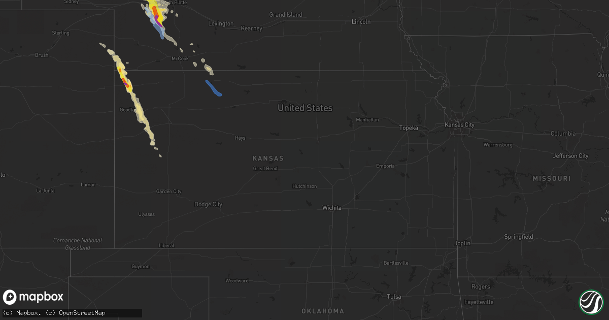
Hail Map in Kansas on May 13, 2021
Get this storm
May 13 map
$229
one time, instant access
Download today. No call, no setup
Keep the $229
Bought the map and want the full workflow? Apply the entire $229 to a subscription within 7 days. None of it is wasted.
Every map, not just this one
This buys you this map. Subscription and you get every map we run, in the markets you choose from a few cities to whole states to nationwide. Plus real-time alerts the moment a storm fires.
Contact data
Name, contact info, occupancy, even credit band for addresses in the footprint. You go from where it hit to who to call.
Become the source they trust
Unlimited branding weather history reports on demand. You already have the documented answer ready for the property owner, and you are the one who showed up with it.
Property data and RoofTrace estimates
Pull up any address you have got, its value and the exact code rules for that jurisdiction, straight from One Click Code. Then RoofTrace estimates the squares, pitch, and roof value, priced the way you price.
Storm reports in Kansas
Kansas
| Date | Description |
|---|---|
| 05/13/20216:51 PM CDT | A local report indicates 1.25 inch wind near 2 NW SAINT FRANCIS |
| 05/13/20216:49 PM CDT | Report from mping: golf ball |
| 05/13/20211:15 PM CDT | Awos station knrn norton. |
| 05/13/20214:50 AM CDT | At 949 PM CDT, a severe thunderstorm was located 10 miles west of Scott State Lake, moving southeast at 30 mph. HAZARD...Quarter size hail. SOURCE...Radar indicated. IMPACT...Damage to vehicles is expected. Locations impacted include... Modoc, Scott City and Shallow Water. |
| 05/13/20214:34 AM CDT | At 934 PM CDT, a severe thunderstorm was located over Russell Springs, or 19 miles northwest of Scott State Lake, moving southeast at 20 mph. HAZARD...Quarter size hail. SOURCE...Radar indicated. IMPACT...Damage to vehicles is expected. This severe thunderstorm will remain over mainly rural areas of southern Logan County. |
| 05/13/20212:29 AM CDT | At 728 PM MDT/828 PM CDT/, a severe thunderstorm was located 4 miles southwest of Brewster, moving southeast at 15 mph. HAZARD...Quarter size hail. SOURCE...Radar indicated. IMPACT...Damage to vehicles is expected. This severe thunderstorm will remain over mainly rural areas of southwestern Thomas and southeastern Sherman Counties, including the following locations... Edson.This includes Interstate 70 in Kansas between mile markers 26 and 39. |
| 05/13/20212:02 AM CDT | At 701 PM CDT, a severe thunderstorm was located 6 miles northeast of St. Francis, moving south at 25 mph. HAZARD...Golf ball size hail. SOURCE...Law enforcement. IMPACT...People and animals outdoors will be injured. Expect damage to roofs, siding, windows, and vehicles. This severe thunderstorm will be near... St. Francis around 705 PM CDT. |
| 05/13/20211:39 AM CDT | At 638 PM MDT/738 PM CDT/, severe thunderstorms were located along a line extending from 14 miles south of St. Francis to 16 miles northeast of Ruleton to 12 miles north of Goodland to 14 miles south of Bird City, moving south at 25 mph. This storm has a history of producing golfball size hail. HAZARD...Golf ball size hail and 60 mph wind gusts. SOURCE...Radar indicated. IMPACT...People and animals outdoors will be injured. Expect hail damage to roofs, siding, windows, and vehicles. Expect wind damage to roofs, siding, and trees. Locations impacted include... Goodland.This includes Interstate 70 in Kansas between mile markers 12 and 34. |
| 05/13/20211:15 AM CDT | Delayed social media report of trees down on the southeast side of town. Time estimated by radar. |
| 05/13/20211:15 AM CDT | Corrects previous tstm wnd gst report from 1 nnw norton. Awos station knrn norton. |
| 05/13/202112:28 AM CDT | At 528 PM MDT/628 PM CDT/, a severe thunderstorm was located 9 miles north of St. Francis, moving south at 20 mph. HAZARD...60 mph wind gusts and quarter size hail. SOURCE...Radar indicated. IMPACT...Hail damage to vehicles is expected. Expect wind damage to roofs, siding, and trees. Locations impacted include... St. Francis. |
| 05/12/202111:41 PM CDT | At 441 PM MDT/541 PM CDT/, a severe thunderstorm was located 8 miles north of Haigler, or 16 miles east of Wray, moving southeast at 20 mph. HAZARD...Ping pong ball size hail and 60 mph wind gusts. SOURCE...Radar indicated. IMPACT...People and animals outdoors will be injured. Expect hail damage to roofs, siding, windows, and vehicles. Expect wind damage to roofs, siding, and trees. This severe thunderstorm will be near... Haigler around 500 PM MDT. |
| 05/12/20219:20 PM CDT | Report from mping: quarter |
| 05/12/20218:29 PM CDT | Delayed report. Time estimated from radar. Dime to half dollar size hail observed on road after storm passed. Road was covered in hail from roughly sherman county road |
| 05/12/20217:21 PM CDT | Report from mping: hen egg |
| 05/12/20217:11 PM CDT | A local report indicates 1.75 inch wind near 12 NW SAINT FRANCIS |
| 05/12/20217:11 PM CDT | A local report indicates 1.75 inch wind near WHEELER |
| 05/12/20217:06 PM CDT | A local report indicates 1.75 inch wind near 1 E SAINT FRANCIS |
| 05/12/20217:00 PM CDT | Dispatch in st francis reporting hail size ranging from nickel to golf ball. |
Cities Impacted by Hail Map on May 13, 2021
- Lance Creek, WY
- Labelle, FL
- Leoti, KS
- Winona, KS
- Edgemont, SD
- Wallace, NE
- Wray, CO
- Ashby, NE
- Colby, KS
- Edson, KS
- Saint Francis, KS
- North Platte, NE
- Weston, WY
- Arthur, NE
- Dickens, NE
- Hershey, NE
- Paxton, NE
- Sutherland, NE
- Elsie, NE
- Haigler, NE
- Keystone, NE
- Brewster, KS
- Goodland, KS
- Hayes Center, NE
- McCook, NE
- Maywood, NE
- Oshkosh, NE
- Ellsworth, NE
- Harrison, NE
- Wellfleet, NE
- Cambridge, NE
- Wilsonville, NE
- Hemingford, NE
- Ogallala, NE
- Bird City, KS
- Hendley, NE
- Norton, KS
- Lebanon, NE
- Indianola, NE
- Crawford, NE
- Parks, NE
- Stockville, NE
- Scott City, KS
- Holyoke, CO
- Lenora, KS


