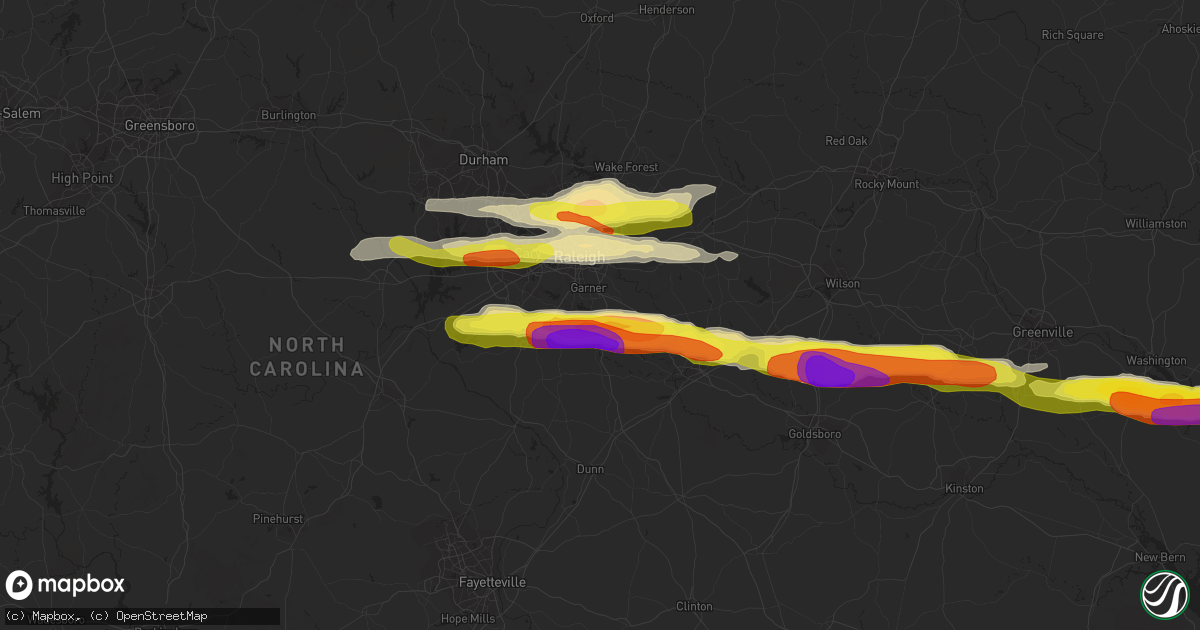
Hail Map in Garner, NC on May 13, 2019
Get this storm
May 13 map
$229
one time, instant access
Download today. No call, no setup
Keep the $229
Bought the map and want the full workflow? Apply the entire $229 to a subscription within 7 days. None of it is wasted.
Every map, not just this one
This buys you this map. Subscription and you get every map we run, in the markets you choose from a few cities to whole states to nationwide. Plus real-time alerts the moment a storm fires.
Contact data
Name, contact info, occupancy, even credit band for addresses in the footprint. You go from where it hit to who to call.
Become the source they trust
Unlimited branding weather history reports on demand. You already have the documented answer ready for the property owner, and you are the one who showed up with it.
Property data and RoofTrace estimates
Pull up any address you have got, its value and the exact code rules for that jurisdiction, straight from One Click Code. Then RoofTrace estimates the squares, pitch, and roof value, priced the way you price.
Storm reports in Garner, NC
Garner, NC
| Date | Description |
|---|---|
| 05/13/201912:47 PM CDT | Spotter reported golf ball size hail in the 1100 block of grissom farm road. |
| 05/13/201912:42 PM CDT | Corrects previous hail report from 5 nne coats crossroads. |
| 05/13/201912:40 PM CDT | A local report indicates 1.75 inch wind near 6 NNW COATS CROSSROADS |
| 05/13/201912:40 PM CDT | Corrects previous hail report from 5 nnw coats crossroads. |
All States Impacted by Hail Map on May 13, 2019
All Cities Impacted by Hail Map on May 13, 2019
- Calumet, OK
- Williamston, NC
- Willow Spring, NC
- Raleigh, NC
- Fuquay Varina, NC
- Garner, NC
- Clayton, NC
- Smithfield, NC
- Apex, NC
- Selma, NC
- Perry, OK
- Stillwater, OK
- Edinburg, TX
- Fremont, NC
- Ashland, KS
- Englewood, KS
- Moncure, NC
- Pittsboro, NC
- Donna, TX
- Alamo, TX
- Belhaven, NC
- Macclesfield, NC
- Elm City, NC
- Pinetops, NC
- Bailey, NC
- Sims, NC
- Wilson, NC
- Columbia, NC
- Robersonville, NC
- Hobgood, NC
- Plymouth, NC
- Hamilton, NC
- Roper, NC
- Oak City, NC
- Creswell, NC
- Windsor, NC
- San Juan, TX
- Rocky Mount, NC
- Tarboro, NC
- Washington, NC
- Greenville, NC
- Grimesland, NC
- Blounts Creek, NC
- Bath, NC
- Chocowinity, NC
- Bethel, NC
- Swanquarter, NC
- Odessa, TX
- Edcouch, TX
- Morrisville, NC
- Cary, NC
- Knightdale, NC
- Pinetown, NC
- Scranton, NC
- Ayden, NC
- Winterville, NC
- Farmville, NC
- Kenly, NC
- Snow Hill, NC
- Walstonburg, NC
- New Hill, NC
- Lucama, NC
- Princeton, NC
- Stantonsburg, NC
- Holly Springs, NC
- Pikeville, NC
- Dryden, TX
- Jamesville, NC
- Cedar Vale, KS
- Geary, OK
- Big Lake, TX
- Wendell, NC
- Dexter, KS
- Rolesville, NC
- Youngsville, NC
- Wake Forest, NC
- Zebulon, NC
- Chapel Hill, NC
- Durham, NC
- Colby, KS
- El Reno, OK
- Mooreland, OK
- Carmen, OK
- Pharr, TX
- Weslaco, TX
- Siler City, NC
- Bear Creek, NC
- Roma, TX
- Ismay, MT
- Cohagen, MT
- Sharon, OK
- Mission, TX
- Post, TX
- Watonga, OK
- Eagle Pass, TX
- Marathon, TX
- Carrizo Springs, TX
- Big Bend National Park, TX
- White Owl, SD
- Hunter, OK
- Bunn, NC
- Middlesex, NC
- Louisburg, NC
- Spring Hope, NC
- Cuttingsville, VT
- Vanceboro, NC
- Oakwood, OK
- Seiling, OK


