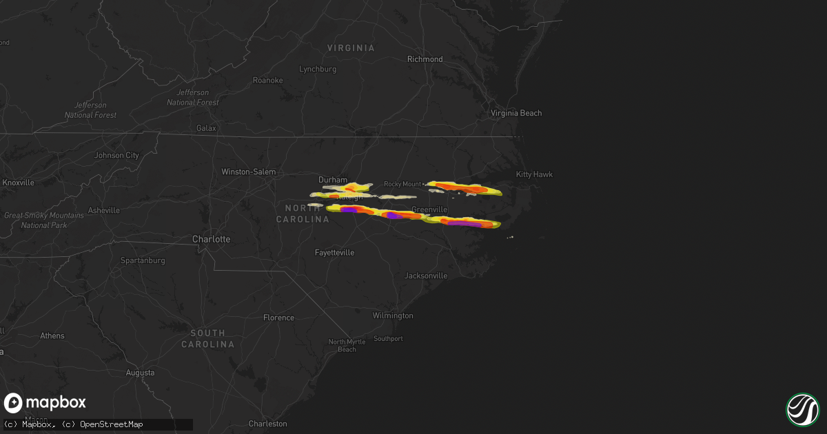
Hail Map on May 13, 2019
Get this storm
May 13 map
$229
one time, instant access
Download today. No call, no setup
Keep the $229
Bought the map and want the full workflow? Apply the entire $229 to a subscription within 7 days. None of it is wasted.
Every map, not just this one
This buys you this map. Subscription and you get every map we run, in the markets you choose from a few cities to whole states to nationwide. Plus real-time alerts the moment a storm fires.
Contact data
Name, contact info, occupancy, even credit band for addresses in the footprint. You go from where it hit to who to call.
Become the source they trust
Unlimited branding weather history reports on demand. You already have the documented answer ready for the property owner, and you are the one who showed up with it.
Property data and RoofTrace estimates
Pull up any address you have got, its value and the exact code rules for that jurisdiction, straight from One Click Code. Then RoofTrace estimates the squares, pitch, and roof value, priced the way you price.
States Impacted by Hail Map on May 13, 2019
Storm reports
North Carolina
| Date | Description |
|---|---|
| 05/13/20193:35 PM CDT | Corrects previous hail report from swan quarter ferry terminal. Reported at 748 oyster creek st... Swanquarter... Nc 27885. |
| 05/13/20193:07 PM CDT | A local report indicates 1.75 inch wind near BAYVIEW FERRY TERMINAL |
| 05/13/20192:48 PM CDT | Spotter sent us a picture showing the actual hail size. |
| 05/13/20192:45 PM CDT | Public reported quarter size hail on highway 33 near near southside high school. |
| 05/13/20192:42 PM CDT | Trained spotter reported quarter size hail near the intersection of chandler rd and highway 17. |
| 05/13/20192:42 PM CDT | Reported at 5703 nc-33... Chocowinity... Nc 27817. |
| 05/13/20192:40 PM CDT | Reported at 3603 nc-33... Chocowinity... Nc. |
| 05/13/20192:35 PM CDT | Trained spotter reported dime to quarter size hail covering the ground. |
| 05/13/20192:35 PM CDT | Golf ball size hail reported at a business just south of hackney. |
| 05/13/20191:50 PM CDT | . |
| 05/13/20191:50 PM CDT | . |
| 05/13/20191:40 PM CDT | Corrects previous hail report from 3 se eureka. |
| 05/13/20191:35 PM CDT | Corrects previous hail report from 2 ene fremont. |
| 05/13/20191:28 PM CDT | Retransmit of lsr. |
| 05/13/20191:28 PM CDT | Corrects previous hail report from 1 nnw nahunta. |
| 05/13/20191:10 PM CDT | A local report indicates 1.25 inch wind near 2 NE SELMA |
| 05/13/20191:00 PM CDT | A local report indicates 1.50 inch wind near 5 S FLOWERS |
| 05/13/201912:55 PM CDT | Corrects previous hail report from 6 sse clayton. |
| 05/13/201912:55 PM CDT | Corrects previous hail report from 4 sw clayton. Golf ball sized hail occurring at jack road and government road in clayton... Nc. |
| 05/13/201912:47 PM CDT | Spotter reported golf ball size hail in the 1100 block of grissom farm road. |
| 05/13/201912:45 PM CDT | Corrects previous hail report from 6 ssw garner. Moorhaven drive on the southside of garner. |
| 05/13/201912:42 PM CDT | Corrects previous hail report from 5 nne coats crossroads. |
| 05/13/201912:40 PM CDT | A local report indicates 1.75 inch wind near 6 NNW COATS CROSSROADS |
| 05/13/201912:40 PM CDT | Corrects previous hail report from 5 nnw coats crossroads. |
| 05/13/201912:39 PM CDT | Corrects previous hail report from 4 s garner. |
| 05/13/201912:32 PM CDT | Report from wsls. |
| 05/13/201912:31 PM CDT | Spotter reported golf ball sized hail on feldmen dr. In raleigh. |
| 05/13/201912:30 PM CDT | Cars damaged... Shingles damaged... Windows broken. |
| 05/13/201912:26 PM CDT | A local report indicates 1.00 inch wind near 3 E HOLLY SPRINGS |
| 05/13/201911:47 AM CDT | Reported at 347 shore dr... Crestwell... Nc. |
| 05/13/201911:34 AM CDT | Golf ball sized hail reported at the vernon g james research center west of roper. |
| 05/13/201911:10 AM CDT | Martin county em reported trees down on a house in the 3500 block of bear grass rd. |
| 05/13/201911:09 AM CDT | Martin county 911 center reports trees down on the 2500 block of price road. |
| 05/13/201911:08 AM CDT | Martin county em reported trees down on the 3600 block of bailey rd. The tops of some trees were twisted off in the area as well. |
| 05/13/201911:07 AM CDT | Public reported half-dollar sized hail northwest of williamston. Time based on radar. |
| 05/13/201911:05 AM CDT | Fencing and tree limbs down. |
| 05/13/201911:02 AM CDT | Member of the nc wildlife commission was on a tractor north of williamston when he observed quarter to golfball sized hail. |
| 05/13/201910:52 AM CDT | Spotter reported quarter to ping pong ball size hail near hamilton. Time based on radar. |
| 05/13/201910:45 AM CDT | A local report indicates 1.00 inch wind near 2 NNE WILSON |
| 05/13/20199:55 AM CDT | Hail up to the size of quarters. |
| 05/13/20199:33 AM CDT | Possible tornado downed numerous trees and power-lines and caused structural damage to homes and barns on massey and brantley roads. |
| 05/13/20199:30 AM CDT | Multiple trees down. Some structures damaged in the brantley rd. Area. |
| 05/13/20199:30 AM CDT | One inch hail reported at piermont dr in cary. |
| 05/13/20199:25 AM CDT | Spotter reported multiple trees down and traffic lights down at east gannon |
| 05/13/20199:25 AM CDT | A local report indicates 1.00 inch wind near 1 SE CARPENTER |
| 05/13/20199:24 AM CDT | Tree down on house. Multiple trees down. |
| 05/13/20199:24 AM CDT | Corrects previous tstm wnd dmg report from 4 ne wendell. Multiple trees down. |
| 05/13/20199:20 AM CDT | Aerial footage from wral clearly shows a damage pattern in the fallen trees that confirms a tornado touchdown. An nws survey team is en route to the damage area to surv |
| 05/13/20199:16 AM CDT | Trained spotter reports following damage on edgemont rd in lowry meadow subdivision |
| 05/13/20199:15 AM CDT | Multiple trees down... Some on homes. Possible tornado touchdown. |
| 05/13/20199:13 AM CDT | Ef-2 tornado confirmed near knightdale to near bailey... Nc on may 13... 2019. Estimated wind speed of 115 mph. Max path width of 385 yards and path length of 17.40 mil |
| 05/13/20199:06 AM CDT | Tree down on power line. |
| 05/13/20198:55 AM CDT | A local report indicates 1.75 inch wind near 4 NNE RALEIGH |
| 05/13/20198:54 AM CDT | Quarter-size hail. |
| 05/13/20197:51 AM CDT | At 1250 PM EDT, a severe thunderstorm was located near Pittsboro, moving east at 45 mph. HAZARD...60 mph wind gusts and half dollar size hail. SOURCE...Radar indicated. IMPACT...Hail damage to vehicles is expected. Expect wind damage to roofs, siding, and trees. Locations impacted include... Raleigh, Cary, Pittsboro, Garner, Fuquay-Varina, Angier, Apex, Holly Springs, Crosswinds Boating Center and Crosswinds Campground. |
| 05/13/20197:28 AM CDT | At 1228 PM EDT, a severe thunderstorm was located near Hinson, or near Plymouth, moving east at 40 mph. HAZARD...60 mph wind gusts and half dollar size hail. SOURCE...Law enforcement. IMPACT...Hail damage to vehicles is expected. Expect wind damage to roofs, siding, and trees. Locations impacted include... Plymouth, Killkenny, Alligator, Gum Neck, Kilkenny, Columbia, Woodley, Wenona, Hinson, Newfoundland, Westover, Pleasant Grove, Scuppernong, Fort Landing, Phelps Lake, Frying Pan Landing, Pungo Lake, Alligator Lake, Mackeys and Roper. |
| 05/13/20196:52 AM CDT | At 1151 AM EDT, a severe thunderstorm was located 9 miles north of Robersonville, or 10 miles northwest of Williamston, moving east at 50 mph. HAZARD...60 mph wind gusts and quarter size hail. SOURCE...Radar indicated. IMPACT...Minor damage to vehicles is possible. Expect wind damage to trees and powerlines. Locations impacted include... Windsor, Midway, Merry Hill, Quitsna, Woodard and Edenhouse. |
| 05/13/20196:43 AM CDT | At 1143 AM EDT, a severe thunderstorm was located near Robersonville, or 13 miles west of Williamston, moving east at 50 mph. HAZARD...60 mph wind gusts and quarter size hail. SOURCE...Radar indicated. IMPACT...Hail damage to vehicles is expected. Expect wind damage to roofs, siding, and trees. Locations impacted include... Williamston, Plymouth, Bethel, Robersonville, Hinson, Long Acre VFD, Gold Point, Jamesville, Hamilton, Oak City, Smithwick, Parmele, Everetts, Dardens, Hassell and Beargrass. |
| 05/13/20196:31 AM CDT | At 1131 AM EDT, a severe thunderstorm was located near Bailey, or 15 miles south of Nashville, moving east at 45 mph. HAZARD...60 mph wind gusts and quarter size hail. SOURCE...Radar indicated. IMPACT...Hail damage to vehicles is expected. Expect wind damage to roofs, siding, and trees. Locations impacted include... Wilson, Elm City, Bailey, Pinetops, Lucama, Stantonsburg, Black Creek, Macclesfield, Saratoga and Conetoe. |
| 05/13/20195:35 AM CDT | At 1035 AM EDT, a severe thunderstorm was located over Cary, moving east at 40 mph. HAZARD...60 mph wind gusts and quarter size hail. SOURCE...Radar indicated. IMPACT...Hail damage to vehicles is expected. Expect wind damage to roofs, siding, and trees. Locations impacted include... Raleigh, Cary, Garner, Clayton, Zebulon, Apex, Holly Springs, Morrisville, Knightdale and Wendell. |
| 05/13/20194:57 AM CDT | At 956 AM EDT, a severe thunderstorm was located near Pittsboro, moving east at 35 mph. HAZARD...60 mph wind gusts and quarter size hail. SOURCE...Radar indicated. IMPACT...Hail damage to vehicles is expected. Expect wind damage to roofs, siding, and trees. Locations impacted include... Raleigh, Durham, Cary, Chapel Hill, Pittsboro, Carrboro, Rdu International, Apex, Holly Springs and Morrisville. |
| 05/13/20194:43 AM CDT | At 943 AM EDT, a severe thunderstorm was located over Rdu International, or near Cary, moving east at 35 mph. HAZARD...60 mph wind gusts and quarter size hail. SOURCE...Radar indicated. IMPACT...Some hail damage to vehicles is expected. Expect minor wind damage to roofs, siding, and trees. Locations impacted include... Raleigh, Durham, Cary, Wake Forest, Zebulon, Bunn, Rdu International, Morrisville, Knightdale and Wendell. |
| 05/12/201910:51 PM CDT | At 350 PM EDT, a severe thunderstorm was located over Goose Creek State Park, or near River Road, moving east at 40 mph. HAZARD...Two inch hail and 60 mph wind gusts. SOURCE...Radar indicated. IMPACT...People and animals outdoors will be injured. Expect hail damage to roofs, siding, windows, and vehicles. Expect wind damage to roofs, siding, and trees. Locations impacted include... Washington, River Road, Sladesville, Ransomville, Swindell Fork, Scranton, Blounts Creek, Pamlico Beach, Lowland, Edward, Royal, Bonnerton, Cox Crossroads, Rose Bay, Bayview, Bunyan, Winsteadville, Core Point, South Creek and Sidney Crossroads. |
| 05/12/201910:08 PM CDT | At 307 PM EDT, a severe thunderstorm was located over Roundtree, or near Ayden, moving east at 40 mph. HAZARD...60 mph wind gusts and half dollar size hail. SOURCE...Radar indicated. IMPACT...Hail damage to vehicles is expected. Expect wind damage to roofs, siding, and trees. Locations impacted include... Greenville, Washington, Winterville, Ayden, River Road, Grifton, Bell Arthur, Blounts Creek, Vanceboro, Cayton, Shelmerdine, Calico, Black Jack, Wilmar, Cox Crossroads, Ormondsville, Bunyan, Roundtree, Dowdy Ficklen Stadium and Goose Creek State Park. |
| 05/12/20199:28 PM CDT | At 228 PM EDT, a severe thunderstorm producing destrucive hail was located near Fremont, or 8 miles north of Goldsboro, moving east at 45 mph. HAZARD...Tennis ball size hail and 60 mph wind gusts. SOURCE...Trained weather spotters. IMPACT...People and animals outdoors will be injured. Expect hail damage to roofs, siding, windows, and vehicles. Expect wind damage to roofs, siding, and trees. Locations impacted include... Goldsboro, Fremont, Lucama, Stantonsburg, Black Creek, Pikeville, Saratoga, Eureka and Nahunta. |
| 05/12/20198:26 PM CDT | At 126 PM EDT, a severe thunderstorm was located near Fuquay-Varina, or 12 miles south of Cary, moving east at 40 mph. HAZARD...60 mph wind gusts and half dollar size hail. SOURCE...Trained weather spotters. IMPACT...Hail damage to vehicles is expected. Expect wind damage to roofs, siding, and trees. Locations impacted include... Raleigh, Cary, Smithfield, Garner, Fuquay-Varina, Clayton, Holly Springs, Micro, Selma and Wendell. |
| 05/12/20198:16 PM CDT | At 116 PM EDT, a severe thunderstorm was located near Woodley, or 22 miles east of Plymouth, moving east at 45 mph. HAZARD...Golf ball size hail and 60 mph wind gusts. SOURCE...Radar indicated. IMPACT...People and animals outdoors will be injured. Expect hail damage to roofs, siding, windows, and vehicles. Expect wind damage to roofs, siding, and trees. Locations impacted include... Stumpy Point, Salvo, Manns Harbor, Waves, Nags Head, Alligator, Gum Neck, Rodanthe, Mashoes, Manteo, East Lake, Whalebone, Buffalo City, Frying Pan Landing, Jockeys Ridge State Park, Roanoke Island Festival Park, Nags Head Fishing Pier, Wanchese, Hatteras Island Fishing Pier and Bodie Island Lighthouse. |
South Dakota
| Date | Description |
|---|---|
| 05/12/20198:43 PM CDT | A local report indicates 65 MPH wind near 1 NE WINNER |
Montana
| Date | Description |
|---|---|
| 05/13/20196:40 PM CDT | 0.25 inches of rain and dime-sized hail. Time estimated from radar. |
| 05/13/20196:24 PM CDT | Hail between dime to quarter sized. 0.3 inches of rain. Wind gust estimated at 30 mph. Time estimated from radar. |
| 05/12/20198:08 PM CDT | A local report indicates 61 MPH wind near 3 WNW MILES CITY |
Oklahoma
| Date | Description |
|---|---|
| 05/13/20192:42 AM CDT | At 742 PM CDT, a severe thunderstorm was located near Bridgeport, moving southeast at 20 mph. HAZARD...Half dollar to ping pong ball size hail and 60 mph wind gusts. SOURCE...Radar indicated. IMPACT...People and animals outdoors will be injured. Expect hail damage to roofs, siding, windows, and vehicles. Expect wind damage to roofs, siding, and trees. Locations impacted include... Hinton, Geary, Hydro and Bridgeport. |
| 05/13/20192:28 AM CDT | At 728 PM CDT, a severe thunderstorm was located 4 miles southwest of Stillwater, moving south at 10 mph. HAZARD...60 mph wind gusts and quarter size hail. SOURCE...Radar indicated. IMPACT...Hail damage to vehicles is expected. Expect wind damage to roofs, siding, and trees. Locations impacted include... Stillwater, Perkins and Ripley. |
| 05/13/20192:15 AM CDT | At 714 PM CDT, a severe thunderstorm was located near Greenfield, moving east at 15 mph. HAZARD...60 mph wind gusts and quarter to half dollar size hail. SOURCE...Radar indicated. IMPACT...Hail damage to vehicles is expected. Expect wind damage to roofs, siding, and trees. Locations impacted include... Geary and Greenfield. |
| 05/13/20191:49 AM CDT | At 649 PM CDT, a severe thunderstorm was located near Lake Carl Blackwell, moving southeast at 20 mph. HAZARD...60 mph wind gusts and quarter size hail. SOURCE...Radar indicated. IMPACT...Hail damage to vehicles is expected. Expect wind damage to roofs, siding, and trees. Locations impacted include... Stillwater, Perkins, Lake Carl Blackwell and Lake Mcmurtry. |
| 05/13/20191:47 AM CDT | At 646 PM CDT, a severe thunderstorm was located near Kendrick, moving southeast at 20 mph. HAZARD...Half dollar to ping pong ball size hail and 60 mph wind gusts. SOURCE...Radar indicated. IMPACT...People and animals outdoors will be injured. Expect hail damage to roofs, siding, windows, and vehicles. Expect wind damage to roofs, siding, and trees. Locations impacted include... Stroud, Davenport, Agra, Kendrick, Avery and Parkland. |
| 05/13/20191:41 AM CDT | At 640 PM CDT, a severe thunderstorm was located near Cherokee, moving east at 25 mph. HAZARD...Ping pong ball size hail and 60 mph wind gusts. SOURCE...Radar indicated. IMPACT...People and animals outdoors will be injured. Expect hail damage to roofs, siding, windows, and vehicles. Expect wind damage to roofs, siding, and trees. Locations impacted include... Cherokee, Jet, Byron, Lambert, Ingersoll, Great Salt Plains Lake and Driftwood. |
| 05/13/201912:39 AM CDT | At 538 PM CDT, a severe thunderstorm was located 5 miles northwest of Oakwood, moving east at 10 mph. HAZARD...60 mph wind gusts and quarter to half dollar size hail. SOURCE...Radar indicated. IMPACT...Hail damage to vehicles is expected. Expect wind damage to roofs, siding, and trees. Locations impacted include... Canton, Oakwood, southeastern Canton Lake and Hucmac. |
| 05/13/201912:11 AM CDT | At 510 PM CDT, a severe thunderstorm was located near Vici, moving southeast at 20 mph. Another strong storm was located 3 miles northwest of Sharon. HAZARD...60 mph wind gusts and quarter to half dollar size hail. SOURCE...Radar indicated. IMPACT...Hail damage to vehicles is expected. Expect wind damage to roofs, siding, and trees. Locations impacted include... Vici, Camargo, Sharon, Mutual and Cestos. |
| 05/12/201911:26 PM CDT | At 426 PM CDT, a severe thunderstorm was located 6 miles northwest of Vici, moving southeast at 15 mph. HAZARD...60 mph wind gusts and quarter size hail. SOURCE...Radar indicated. IMPACT...Hail damage to vehicles is expected. Expect wind damage to roofs, siding, and trees. Locations impacted include... Vici. |
| 05/12/201911:20 PM CDT | At 419 PM CDT, a severe thunderstorm was located near Quinlan, moving southeast at 15 mph. HAZARD...65 mph wind gusts and quarter size hail. SOURCE...Radar indicated. IMPACT...Hail damage to vehicles is expected. Expect wind damage to roofs, siding, and trees. Locations impacted include... Waynoka, Quinlan, Alabaster Caverns State Park and Bouse Junction. |
| 05/12/20197:52 PM CDT | Em relayed on nwschat |
| 05/12/20197:09 PM CDT | Report relayed through em in nwschat |
Texas
| Date | Description |
|---|---|
| 05/13/20196:40 AM CDT | At 1139 PM CDT, a severe thunderstorm was located 8 miles southeast of El Indio, moving southeast at 25 mph. HAZARD...Golf ball size hail and 60 mph wind gusts. SOURCE...Radar indicated. IMPACT...People and animals outdoors will be injured. Expect hail damage to roofs, siding, windows, and vehicles. Expect wind damage to roofs, siding, and trees. This severe thunderstorm will remain over mainly rural areas of southeastern Maverick and southwestern Dimmit Counties. |
| 05/13/20196:13 AM CDT | At 1113 PM CDT, a severe thunderstorm was located near El Indio, moving east at 25 mph. HAZARD...60 mph wind gusts and half dollar size hail. SOURCE...Radar indicated. IMPACT...Hail damage to vehicles is expected. Expect wind damage to roofs, siding, and trees. Locations impacted include... El Indio. |
| 05/13/20195:25 AM CDT | Hidalgo county em reports a roof blown off a mobile home in north alamo. Time estimated by radar. |
| 05/13/20195:25 AM CDT | Hidalgo county em reports several downed trees and fences in the city of north alamo. Time estimated by radar. |
| 05/13/20195:14 AM CDT | Public estimated quarter size hail falling in the city of alamo at 5:14 am via social media report. |
| 05/13/20195:10 AM CDT | Downed tree in south alamo. Report relayed via social media. Time estimated by radar. |
| 05/13/20195:00 AM CDT | Public reported golf ball size hail 2.7 miles south of alamo at 5:00 am |
| 05/13/20195:00 AM CDT | The santa ana national wildlife refuge reported a large tree down on the road... Taking some power lines down with it around 5:00 am. |
| 05/13/201912:32 AM CDT | At 532 PM CDT, a severe thunderstorm was located 16 miles north of Reagan County Airport, or 16 miles north of Big Lake, and is nearly stationary. HAZARD...Ping pong ball size hail and 60 mph wind gusts. SOURCE...Radar indicated. IMPACT...People and animals outdoors will be injured. Expect hail damage to roofs, siding, windows, and vehicles. Expect wind damage to roofs, siding, and trees. Locations impacted include... Stiles. |
| 05/13/201912:03 AM CDT | At 502 PM CDT, a severe thunderstorm was located 25 miles southwest of Garden City, moving north at 15 mph. HAZARD...60 mph wind gusts and quarter size hail. SOURCE...Radar indicated. IMPACT...Hail damage to vehicles is expected. Expect wind damage to roofs, siding, and trees. Locations impacted include... Midkiff. |
| 05/12/201911:07 PM CDT | At 407 PM CDT, a severe thunderstorm was located 16 miles north of Dryden, moving north at 25 mph. HAZARD...Golf ball size hail and 60 mph wind gusts. SOURCE...Radar indicated. IMPACT...People and animals outdoors will be injured. Expect hail damage to roofs, siding, windows, and vehicles. Expect wind damage to roofs, siding, and trees. This severe thunderstorm will remain over mainly rural areas of southeastern Pecos and north central Terrell Counties. |
| 05/12/201910:36 PM CDT | At 336 PM CDT, a severe thunderstorm was located 7 miles east of Persimmon Gap, or 24 miles northeast of Panther Junction, moving east at 30 mph. HAZARD...60 mph wind gusts and half dollar size hail. SOURCE...Radar indicated. IMPACT...Hail damage to vehicles is expected. Expect wind damage to roofs, siding, and trees. This severe thunderstorm will remain over mainly rural areas of central Brewster County. |
| 05/12/20199:46 PM CDT | At 246 PM CDT, a severe thunderstorm was located near Odessa, moving north at 15 mph. HAZARD...60 mph wind gusts and quarter size hail. SOURCE...Radar indicated. IMPACT...Hail damage to vehicles is expected. Expect wind damage to roofs, siding, and trees. Locations impacted include... Midland, Odessa, Midland International Air and Space Port, West Odessa, Odessa Schlemeyer Field, Warfield and Midland Airpark.This includes Interstate 20 between mile markers 109 and 134. |
Kansas
| Date | Description |
|---|---|
| 05/13/20196:25 PM CDT | A local report indicates 1.00 inch wind near 6 N ACRES |
| 05/13/20191:26 AM CDT | At 626 PM CDT, a severe thunderstorm was located near Ashland, moving northeast at 15 mph. HAZARD...60 mph wind gusts and quarter size hail. SOURCE...Radar indicated. IMPACT...Hail damage to vehicles is expected. Expect wind damage to roofs, siding, and trees. Locations impacted include... Ashland, Sitka and Acres. |
Idaho
| Date | Description |
|---|---|
| 05/13/20195:26 PM CDT | 5 to 6 power poles snapped off just above the ground by outflow winds from a decaying thunderstorm just south of darlington near the mouth of antelope creek. Reported b |
| 05/12/20197:50 PM CDT | Mesonet station cra. Thunderstorm outflow winds. |
Florida
| Date | Description |
|---|---|
| 05/13/20193:28 PM CDT | Park ranger at jonathan dickinson state park reported a tree down along with several large branches on park road near the north fork loxahatchee river. Time estimated f |
| 05/13/20191:02 PM CDT | Public reported a large uprooted tree in the mira flores apartment complex in palm beach gardens via social media. Time estimated from radar of 202 pm edt. |
| 05/12/201911:27 PM CDT | At 427 PM EDT, a severe thunderstorm was located over Jupiter Island, moving northeast at 30 mph. HAZARD...60 mph wind gusts. SOURCE...Radar indicated. IMPACT...Expect damage to roofs, siding, and trees. Locations impacted include... Tequesta, Jupiter Island, Hobe Sound, Hobe Sound Beach and Jonathan Dickinson State Park. |
| 05/12/201911:04 PM CDT | At 404 PM EDT, a severe thunderstorm was located over Tradition, or near Port Saint Lucie, moving east at 35 mph. HAZARD...60 mph wind gusts. SOURCE...Radar indicated. IMPACT...Expect damage to roofs, siding, and trees. Locations impacted include... Port Saint Lucie, Walton, Fort Pierce, Stuart and Saint Lucie Nuclear Power Plant. |
| 05/12/201910:07 PM CDT | At 306 AM CDT, a severe thunderstorm was located over Ensley, moving east at 25 mph. HAZARD...60 mph wind gusts and penny size hail. SOURCE...Radar indicated. IMPACT...Expect damage to roofs, siding, and trees. Locations impacted include... Ferry Pass, Brent, Ensley, Gonzalez, Pace, Milton, Bagdad, Pea Ridge and Floridatown. |
| 05/12/20199:45 PM CDT | At 245 PM EDT, a severe thunderstorm was located over Wabasso, moving northeast at 15 mph. HAZARD...60 mph wind gusts and quarter size hail. SOURCE...Radar indicated. IMPACT...Hail damage to vehicles is expected. Expect wind damage to roofs, siding, and trees. Locations impacted include... Sebastian, Indian River Shores, Wabasso, Roseland and Winter Beach. |
| 05/12/20199:39 PM CDT | At 239 PM EDT, a severe thunderstorm was located over Barefoot Bay, moving east at 20 mph. HAZARD...60 mph wind gusts and quarter size hail. SOURCE...Radar indicated. IMPACT...Hail damage to vehicles is expected. Expect wind damage to roofs, siding, and trees. Locations impacted include... Barefoot Bay, Sebastian Inlet, Roseland, Micco and Melbourne Shores. |
| 05/12/20198:56 PM CDT | At 156 PM EDT, a severe thunderstorm was located over Palm Beach Gardens, moving northeast at 25 mph. HAZARD...60 mph wind gusts. SOURCE...Radar indicated. IMPACT...Expect damage to roofs, siding, and trees. Locations impacted include... West Palm Beach, Jupiter, Palm Beach Gardens, Riviera Beach and Juno Beach. |
Louisiana
| Date | Description |
|---|---|
| 05/12/201910:11 PM CDT | At 310 AM CDT, a severe thunderstorm was located near Buras, or 16 miles southeast of Port Sulphur, moving east at 25 mph. HAZARD...60 mph wind gusts and quarter size hail. SOURCE...Radar indicated. IMPACT...Hail damage to vehicles is expected. Expect wind damage to roofs, siding, and trees. Locations impacted include... Buras, Venice, Empire and Boothville. |
Cities Impacted by Hail Map on May 13, 2019
- Calumet, OK
- Williamston, NC
- Willow Spring, NC
- Raleigh, NC
- Fuquay Varina, NC
- Garner, NC
- Clayton, NC
- Smithfield, NC
- Apex, NC
- Selma, NC
- Perry, OK
- Stillwater, OK
- Edinburg, TX
- Fremont, NC
- Ashland, KS
- Englewood, KS
- Moncure, NC
- Pittsboro, NC
- Donna, TX
- Alamo, TX
- Belhaven, NC
- Macclesfield, NC
- Elm City, NC
- Pinetops, NC
- Bailey, NC
- Sims, NC
- Wilson, NC
- Columbia, NC
- Robersonville, NC
- Hobgood, NC
- Plymouth, NC
- Hamilton, NC
- Roper, NC
- Oak City, NC
- Creswell, NC
- Windsor, NC
- San Juan, TX
- Rocky Mount, NC
- Tarboro, NC
- Washington, NC
- Greenville, NC
- Grimesland, NC
- Blounts Creek, NC
- Bath, NC
- Chocowinity, NC
- Bethel, NC
- Swanquarter, NC
- Odessa, TX
- Edcouch, TX
- Morrisville, NC
- Cary, NC
- Knightdale, NC
- Pinetown, NC
- Scranton, NC
- Ayden, NC
- Winterville, NC
- Farmville, NC
- Kenly, NC
- Snow Hill, NC
- Walstonburg, NC
- New Hill, NC
- Lucama, NC
- Princeton, NC
- Stantonsburg, NC
- Holly Springs, NC
- Pikeville, NC
- Dryden, TX
- Jamesville, NC
- Cedar Vale, KS
- Geary, OK
- Big Lake, TX
- Wendell, NC
- Dexter, KS
- Rolesville, NC
- Youngsville, NC
- Wake Forest, NC
- Zebulon, NC
- Chapel Hill, NC
- Durham, NC
- Colby, KS
- El Reno, OK
- Mooreland, OK
- Carmen, OK
- Pharr, TX
- Weslaco, TX
- Siler City, NC
- Bear Creek, NC
- Roma, TX
- Ismay, MT
- Cohagen, MT
- Sharon, OK
- Mission, TX
- Post, TX
- Watonga, OK
- Eagle Pass, TX
- Marathon, TX
- Carrizo Springs, TX
- Big Bend National Park, TX
- White Owl, SD
- Hunter, OK
- Bunn, NC
- Middlesex, NC
- Louisburg, NC
- Spring Hope, NC
- Cuttingsville, VT
- Vanceboro, NC
- Oakwood, OK
- Seiling, OK