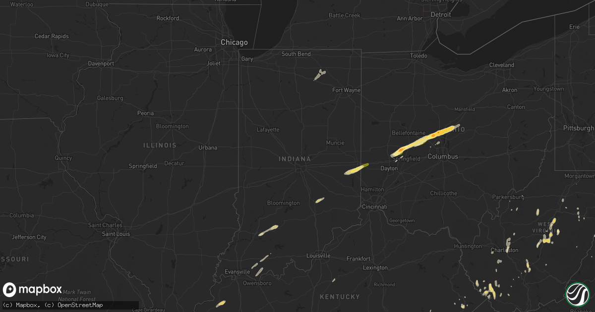
Hail Map in Indiana on May 13, 2014
Get this storm
May 13 map
$229
one time, instant access
Download today. No call, no setup
Keep the $229
Bought the map and want the full workflow? Apply the entire $229 to a subscription within 7 days. None of it is wasted.
Every map, not just this one
This buys you this map. Subscription and you get every map we run, in the markets you choose from a few cities to whole states to nationwide. Plus real-time alerts the moment a storm fires.
Contact data
Name, contact info, occupancy, even credit band for addresses in the footprint. You go from where it hit to who to call.
Become the source they trust
Unlimited branding weather history reports on demand. You already have the documented answer ready for the property owner, and you are the one who showed up with it.
Property data and RoofTrace estimates
Pull up any address you have got, its value and the exact code rules for that jurisdiction, straight from One Click Code. Then RoofTrace estimates the squares, pitch, and roof value, priced the way you price.
Storm reports in Indiana
Indiana
| Date | Description |
|---|---|
| 05/13/20146:40 PM CDT | Power lines down. Winds estimated at 50 mph. Also nickel size hail. |
| 05/13/20146:32 PM CDT | Grandstands at edinburgh community high school on west side of town were bent in two and dragged onto the race track and football field...numerous trees down in cemeter |
| 05/13/20146:30 PM CDT | Trees down blocking several roads. Delayed report. |
| 05/13/20145:24 PM CDT | Pole barn with doors open blown down. |
| 05/13/20141:15 PM CDT | Power lines down on rangeline road...closing the road...uncertain if weather related...time estimated. |
| 05/13/201412:20 PM CDT | Tree down...paritally blocking state route 9 |
| 05/12/20149:00 PM CDT | Grandstands at edinburgh community high school on west side of town were bent in two and dragged onto the race track and football field...numerous trees down in cemeter |
| 05/12/20148:57 PM CDT | Power poles bent with large trees down. West of waldron. |
| 05/12/20148:04 PM CDT | Several trees and lines down in brownsville and clifton areas. Time estimated from radar. |
| 05/12/20147:50 PM CDT | 2 trees down including 1 near ohio ave and w 19th st...and 1 at vine st and alquina rd. Time estimated from radar. |
| 05/12/20147:39 PM CDT | 1 tree down at columbia rd and tower rd. Time estimated from radar. |
| 05/12/20147:02 PM CDT | Report from weather bug site and relayed from ema...time estimated |
All States Impacted by Hail Map on May 13, 2014
Cities Impacted by Hail Map on May 13, 2014
- Maurertown, VA
- Woodstock, VA
- Gerrardstown, WV
- Winchester, VA
- Great Cacapon, WV
- Paw Paw, WV
- Abingdon, VA
- Medway, OH
- New Carlisle, OH
- Clinton, MS
- Bolton, MS
- Raymond, MS
- Busy, KY
- Hazard, KY
- Bonnyman, KY
- Acme, PA
- Mount Pleasant, PA
- Ostrander, OH
- Delaware, OH
- Marysville, OH
- Richland, IN
- Grandview, IN
- Chrisney, IN
- Rockport, IN
- Oswego, NY
- Fulton, NY
- Minetto, NY
- Brownsville, TN
- Fallentimber, PA
- Smithmill, PA
- Campbell, NY
- Bradford, NY
- Painted Post, NY
- Beaver Dams, NY
- Iaeger, WV
- Diana, WV
- Hacker Valley, WV
- Star Tannery, VA
- Tyrone, PA
- Port Matilda, PA
- Burlington, WV
- Keyser, WV
- Moorefield, WV
- Milam, WV
- Reston, VA
- Oakton, VA
- Fairfax, VA
- Herndon, VA
- Arlington, TN
- Memphis, TN
- Springfield, OH
- Urbana, OH
- Saint Paris, OH
- Coxs Mills, WV
- Glenville, WV
- Milford, VA
- Sutton, WV
- Erbacon, WV
- Cowen, WV
- Little Birch, WV
- Birch River, WV
- Franklin, WV
- Upper Tract, WV
- Silver Springs, NY
- Cardington, OH
- Radnor, OH
- Marengo, OH
- Woodstock, OH
- North Lewisburg, OH
- Fulton, OH
- Milford Center, OH
- Ashley, OH
- Cable, OH
- Kelly, LA
- Grayson, LA
- Olla, LA
- Ubly, MI
- Snover, MI
- Wayland, NY
- Clearville, PA
- Artemas, PA
- Green Spring, WV
- Springfield, WV
- Oldtown, MD
- Walkersville, WV
- Orlando, WV
- Napier, WV
- Heaters, WV
- Burnsville, WV
- Flatwoods, WV
- Oak Hill, WV
- Scarbro, WV
- Stephens City, VA
- Richmond, IN
- Brownsville, IN
- Centerville, IN
- Liberty, IN
- Belzoni, MS
- Sidon, MS
- Itta Bena, MS
- Water Valley, KY
- Fulton, KY
- Wingo, KY
- Hammondsport, NY
- Bath, NY
- Waterford, VA
- Paeonian Springs, VA
- Lovettsville, VA
- Leesburg, VA
- Harold, KY
- Riverton, WV
- Brandywine, WV
- Gentryville, IN
- Tennyson, IN
- Boonville, IN
- Ravencliff, WV
- Savona, NY
- Stanton, TN
- Fulks Run, VA
- Hannibal, NY
- Fort Ashby, WV
- Wharncliffe, WV
- White Pine, TN
- Mineral Point, PA
- South Fork, PA
- Johnstown, PA
- Shady Valley, TN
- Fayetteville, WV
- Fairmont, WV
- Luray, VA
- Ruther Glen, VA
- Stafford, VA
- Fredericksburg, VA
- Tipp City, OH
- Casstown, OH
- Troy, OH
- Baisden, WV
- Delbarton, WV
- North Spring, WV
- Sarah Ann, WV
- Matewan, WV
- Gilbert, WV
- Verner, WV
- Mohawk, WV
- Majestic, KY
- Hanover, WV
- Panther, WV
- Buckhannon, WV
- Gauley Bridge, WV
- Ansted, WV
- Harman, WV
- Greenwood, MS
- Limestone, TN
- Chuckey, TN
- Ebensburg, PA
- Summerhill, PA
- Parkhill, PA
- Cosby, TN
- Newport, TN
- Pennsylvania Furnace, PA
- Edinburgh, IN
- Tellico Plains, TN
- Prattsburgh, NY
- Dickerson, MD
- Beaverdam, VA
- Monterey, VA
- Warm Springs, VA
- Montgomery, IN
- Mason, TN
- Irvona, PA
- Trenton, TN
- Vintondale, PA
- Marion, KY
- Clay, KY
- Altoona, PA
- Hollidaysburg, PA
- Duncansville, PA
- Mitchells, VA
- Culpeper, VA
- Rapidan, VA
- Bunker Hill, WV
- Madison, VA
- Providence, KY
- Deford, MI
- Cass City, MI
- Sod, WV
- Hartford, TN
- Ridgeley, WV
- Linden, MI
- Fenton, MI
- Senatobia, MS
- Circleville, WV
- Bristol, TN
- Mount Jackson, VA
- Portage, PA
- Strasburg, VA
- Sperryville, VA
- Syria, VA
- Etlan, VA
- Walton, WV
- McCarr, KY
- Shoals, IN
- Mitchell, IN
- Davin, WV
- Mallory, WV
- Amherstdale, WV
- Man, WV
- Elkins, WV
- Saint Marys, WV
- Tornado, WV
- Plain City, OH
- Mount Hope, WV
- High View, WV
- Yellow Spring, WV
- Connersville, IN
- Mechanicsburg, OH
- Chesterville, OH
- Sunbury, OH
- Fredericktown, OH
- Mount Gilead, OH
- Seneca Rocks, WV
- Montour Falls, NY
- Odessa, NY
- Sterling, NY
- Martville, NY
- Wardensville, WV
- Edinburg, VA
- Toms Brook, VA
- Bulls Gap, TN
- Mosheim, TN
- Quinwood, WV
- Pikeville, KY
- Doswell, VA
- Ashburn, VA
- Poolesville, MD
- Sterling, VA
- McDowell, KY
- Hi Hat, KY
- Bradford, TN
- Petersburg, WV
- Charleston, WV
- Warsaw, IN
- Boston, IN
- Eaton, OH
- Coalton, WV
- Norton, WV
- Watkins Glen, NY
- Mayfield, KY
- Sedalia, KY
- Farmington, KY
- Dille, WV
- Maysville, WV
- Holden, WV
- Logan, WV
- Flintstone, MD
- Williams, IN
- Loogootee, IN
- Hedgesville, WV
- Jeffrey, WV
- Danville, WV
- Canandaigua, NY
- Madisonville, TN
- Powell, OH
- Cross Junction, VA
- Gore, VA
- Baker, WV
- Cannelburg, IN
- Glenwood, IN
- Shelbiana, KY
- Cromwell, IN
- Syracuse, IN
- North Webster, IN
- Kimmell, IN
- Normalville, PA
- New Paris, OH
- Mount Solon, VA
- Leesburg, IN
- Coldwater, MS
- Mexico, NY
- Slatyfork, WV
- Lenore, WV
- Williamson, WV
- Romney, WV
- Elkview, WV
- Rushville, IN
- Manilla, IN
- Points, WV
- Levels, WV
- Woodville, VA
- Boston, VA
- Dublin, OH
- Elizabeth, WV
- Virgie, KY
- Belington, WV
- Staunton, VA
- Churchville, VA
- Palestine, WV
- Dysart, PA
- Nanty Glo, PA
- Robinson Creek, KY
- Phelps, NY
- Newark, NY
- Bellefonte, PA
- Howard, PA
- Hartsville, IN
- Columbus, IN
- Pineville, WV
- Front Royal, VA
- Shelbyville, IN
- Greensburg, IN
- Westport, IN
- Cumberland, MD
- Bardstown, KY
- Loretto, PA
- Ashville, PA
- Waldron, IN
- Milroy, IN
- Milton, IN
- Rock Creek, WV
- Arnett, WV
- Humboldt, TN
- Alamo, TN
- Midway, TN
- Hancock, MD
- Greenfield, TN
- Glen Allen, VA
- Knoxville, TN
- Mabie, WV
- Mineral Wells, WV
- Greeneville, TN
- Julian, PA
- Saint Anthony, IN
- Osceola Mills, PA
- Philipsburg, PA
- Partlow, VA
- Spotsylvania, VA
- Fort Valley, VA
- Naples, NY
- Mount Clare, WV
- Lost Creek, WV
- Clarksburg, WV
- Springwater, NY
- Brightwood, VA
- Reva, VA
- Philippi, WV
- Ferdinand, IN
- Dale, IN
- Huntingburg, IN
- Sugar Grove, WV
- Beallsville, MD
- Costa, WV
- Nellis, WV
- Julian, WV
- Ridgeview, WV
- Ashford, WV
- Peytona, WV
- Clay, WV
- Summersville, WV
- Beckley, WV
- Eldorado, OH
- North Hampton, OH


