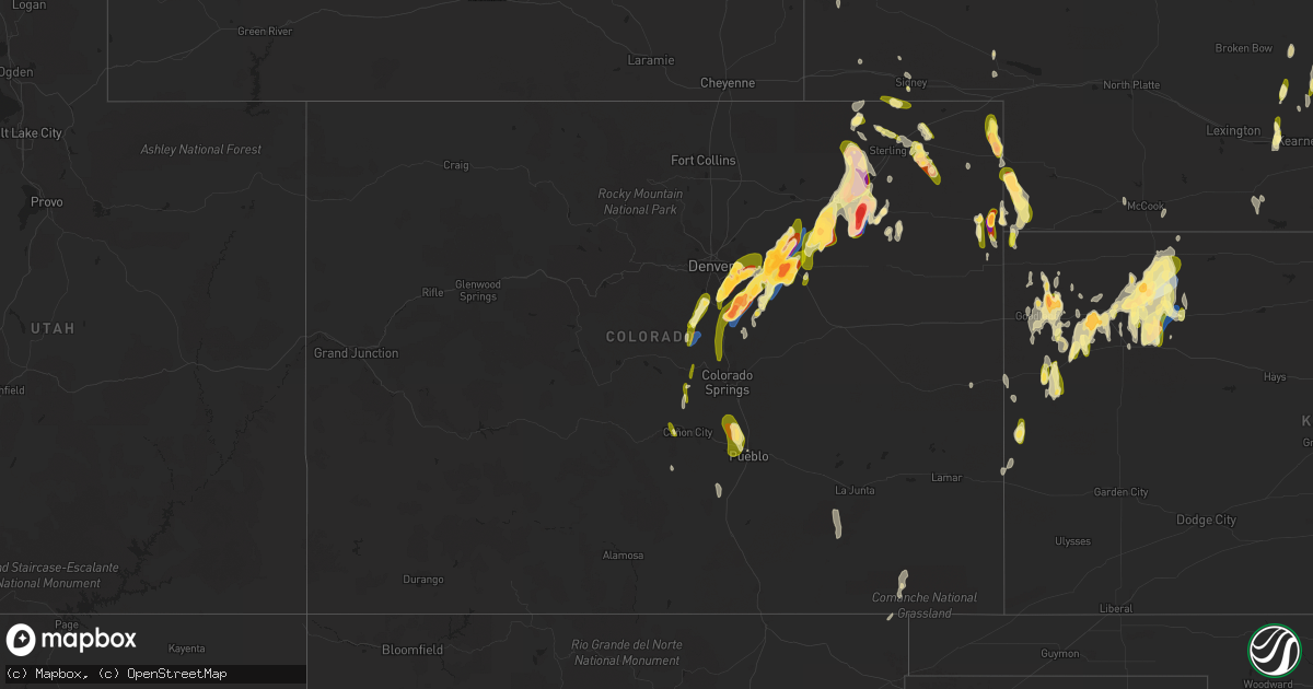
Hail Map in Colorado on May 10, 2023
Get this storm
May 10 map
$229
one time, instant access
Download today. No call, no setup
Keep the $229
Bought the map and want the full workflow? Apply the entire $229 to a subscription within 7 days. None of it is wasted.
Every map, not just this one
This buys you this map. Subscription and you get every map we run, in the markets you choose from a few cities to whole states to nationwide. Plus real-time alerts the moment a storm fires.
Contact data
Name, contact info, occupancy, even credit band for addresses in the footprint. You go from where it hit to who to call.
Become the source they trust
Unlimited branding weather history reports on demand. You already have the documented answer ready for the property owner, and you are the one who showed up with it.
Property data and RoofTrace estimates
Pull up any address you have got, its value and the exact code rules for that jurisdiction, straight from One Click Code. Then RoofTrace estimates the squares, pitch, and roof value, priced the way you price.
Storm reports in Colorado
Colorado
| Date | Description |
|---|---|
| 05/10/20236:55 PM CDT | Weak tornado. |
| 05/10/20236:54 PM CDT | Approximate location. Trained spotters reported tornado on the ground. |
| 05/10/20236:51 PM CDT | Delayed report via spotternetwork. |
| 05/10/20236:38 PM CDT | Delayed report via spotternetwork. |
| 05/10/20236:35 PM CDT | Delayed report via spotternetwork. |
| 05/10/20236:34 PM CDT | Corrects previous hail report from 3 ene woodrow. |
| 05/10/20236:32 PM CDT | Delayed report via spotternetwork. |
| 05/10/20236:30 PM CDT | Report from mping: hen egg |
| 05/10/20236:17 PM CDT | Spotter reported hail up to the size of golf balls. There were only a few stones and the hail did not last long. |
| 05/10/20236:05 PM CDT | A local report indicates 1.75 inch wind near 5 N STRASBURG |
| 05/10/20235:56 PM CDT | A local report indicates 1.25 inch wind near 9 N DEER TRAIL |
| 05/10/20235:52 PM CDT | Report from mping: quarter |
| 05/10/20235:50 PM CDT | A local report indicates 2.50 inch wind near STRASBURG |
| 05/10/20235:50 PM CDT | A local report indicates 1.50 inch wind near 2 N FOXFIELD |
| 05/10/20235:48 PM CDT | Corrects previous hail report from 3 e wray. Report via twitter with photo of hail up to 2 inch in diameter east of wray... Co. |
| 05/10/20235:47 PM CDT | A local report indicates 2.75 inch wind near 1 N STRASBURG |
| 05/10/20235:46 PM CDT | Report from mping: quarter |
| 05/10/20235:45 PM CDT | Baseball size hail reported by law enforcement. |
| 05/10/20235:44 PM CDT | Smashed car windshield. |
| 05/10/20235:44 PM CDT | Baseball sized hail smashed car window. |
| 05/10/20235:39 PM CDT | A local report indicates 1.75 inch wind near 3 WSW STRASBURG |
| 05/10/20235:39 PM CDT | Report from mping: half dollar |
| 05/10/20235:34 PM CDT | Pea to quarter size hail and estimated 40-50 mph winds reported by a trained spotter. |
| 05/10/20235:31 PM CDT | A local report indicates 1.25 inch wind near 3 SE AURORA |
| 05/10/20235:30 PM CDT | A local report indicates 1.75 inch wind near 2 NNE FOXFIELD |
| 05/10/20235:23 PM CDT | A local report indicates 2.00 inch wind near 1 NW STRASBURG |
| 05/10/20235:20 PM CDT | A local report indicates 1.00 inch wind near 6 NNE PUEBLO WEST |
| 05/10/20235:20 PM CDT | A local report indicates 1.50 inch wind near 9 SE ARAPAHOE PARK |
| 05/10/20235:17 PM CDT | A local report indicates 1.00 inch wind near 3 NE FOXFIELD |
| 05/10/20235:16 PM CDT | Report from mping: quarter |
| 05/10/20235:16 PM CDT | Report from mping: half dollar |
| 05/10/20235:15 PM CDT | Report from mping: quarter |
| 05/10/20235:13 PM CDT | Report from mping: quarter |
| 05/10/20235:08 PM CDT | Report from mping: golf ball |
| 05/10/20235:07 PM CDT | Report from mping: golf ball |
| 05/10/20235:06 PM CDT | A local report indicates 1.00 inch wind near 2 SE PUEBLO WEST |
| 05/10/20235:05 PM CDT | A local report indicates 1.25 inch wind near 1 W BUCKLEY AFB |
| 05/10/20235:05 PM CDT | A local report indicates 1.75 inch wind near 2 ENE FRANKTOWN |
| 05/10/20235:04 PM CDT | A local report indicates 1.00 inch wind near 3 S BUCKLEY AFB |
| 05/10/20235:02 PM CDT | Report from mping: quarter |
| 05/10/20235:00 PM CDT | A local report indicates 1.50 inch wind near 2 S FOXFIELD |
| 05/10/20235:00 PM CDT | A local report indicates 1.75 inch wind near 1 S DENVER |
| 05/10/20234:59 PM CDT | Report from mping: quarter |
| 05/10/20234:59 PM CDT | A local report indicates 1.50 inch wind near 2 NNE FOXFIELD |
| 05/10/20234:57 PM CDT | Report from mping: half dollar |
| 05/10/20234:57 PM CDT | Report from mping: ping pong ball |
| 05/10/20234:56 PM CDT | A local report indicates 1.00 inch wind near 3 E CHERRY CREEK RESERV |
| 05/10/20234:56 PM CDT | . |
| 05/10/20234:55 PM CDT | Report from mping: ping pong ball |
| 05/10/20234:50 PM CDT | A local report indicates 1.00 inch wind near FRANKTOWN |
| 05/10/20234:41 PM CDT | A local report indicates 1.25 inch wind near 2 NW CASTLEWOOD CANYON |
| 05/10/20234:20 PM CDT | Hail reported in mueller state park... Posted in a picture on twitter. |
| 05/10/20234:03 PM CDT | A local report indicates 1.00 inch wind near PALMER LAKE |
| 05/09/20237:40 PM CDT | A local report indicates 1.00 inch wind near 3 NE PROCTOR |
| 05/09/20237:39 PM CDT | Weak tornado. |
| 05/09/20237:32 PM CDT | A local report indicates a tornado near 6 WSW AKRON |
| 05/09/20237:30 PM CDT | A local report indicates a tornado near 4 S FREMONT BUTTE |
| 05/09/20237:25 PM CDT | Corrects previous hail report from 6 ssw midway. |
| 05/09/20237:25 PM CDT | A local report indicates 2.80 inch wind near 6 SSW MIDWAY |
| 05/09/20237:23 PM CDT | A local report indicates a tornado near 5 S MIDWAY |
| 05/09/20237:21 PM CDT | A local report indicates a tornado near 2 W MIDWAY |
| 05/09/20237:21 PM CDT | Delayed report via spotternetwork. |
| 05/09/20237:20 PM CDT | A local report indicates 2.00 inch wind near 2.5 SSW HILLROSE |
| 05/09/20237:19 PM CDT | Asos station kako akron. |
| 05/09/20237:18 PM CDT | Landspout briefly on ground. |
| 05/09/20237:14 PM CDT | A local report indicates 2.75 inch wind near 3 ENE WOODROW |
| 05/09/20237:13 PM CDT | A local report indicates 4.00 inch wind near 6 ENE GARY |
| 05/09/20237:10 PM CDT | A local report indicates 3.00 inch wind near 7 WSW AKRON |
All States Impacted by Hail Map on May 10, 2023
Cities Impacted by Hail Map on May 10, 2023
- George West, TX
- Three Rivers, TX
- Sandia, TX
- Drummonds, TN
- Munford, TN
- Brighton, TN
- Colby, KS
- Monument, KS
- Winona, KS
- Hoxie, KS
- Sedalia, CO
- Conifer, CO
- Wallace, KS
- Edson, KS
- Selden, KS
- Littleton, CO
- Jeffrey City, WY
- Usaf Academy, CO
- Colorado Springs, CO
- Monument, CO
- Palmer Lake, CO
- Woodland Park, CO
- Larkspur, CO
- Louviers, CO
- Castle Rock, CO
- Lone Tree, CO
- Parker, CO
- Williston, FL
- Bronson, FL
- Sharon Springs, KS
- Franktown, CO
- Englewood, CO
- Tribune, KS
- Divide, CO
- Aurora, CO
- Cotopaxi, CO
- Canon City, CO
- Florissant, CO
- Levant, KS
- Elizabeth, CO
- Rexford, KS
- Pecos, TX
- Watkins, CO
- Cripple Creek, CO
- Pueblo, CO
- Hartselle, AL
- Saint Francis, KS
- Denver, CO
- Haigler, NE
- Parks, NE
- Bennett, CO
- Dresden, KS
- Strasburg, CO
- Wray, CO
- Fargo, GA
- Jennings, KS
- Oberlin, KS
- Champion, NE
- Kiowa, CO
- Byers, CO
- Holyoke, CO
- Counce, TN
- Somerville, TN
- New Site, MS
- Booneville, MS
- Tuscumbia, AL
- Waynesboro, TN
- Corinth, MS
- Walnut, MS
- Middleton, TN
- Lutts, TN
- Olivehill, TN
- Savannah, TN
- Saint George, GA
- Glen Saint Mary, FL
- Sanderson, FL
- Grand Junction, TN
- Hickory Valley, TN
- Bells, TN
- Syracuse, KS
- Turrell, AR
- Bassett, AR
- Gilmore, AR
- Lake City, AR
- Redford, MO
- Ellington, MO
- Gem, KS
- Burlison, TN
- Paragould, AR
- Beech Grove, AR
- Bird City, KS
- Henning, TN
- Atoka, TN
- Wilson, AR
- Osceola, AR
- Brewster, KS
- Goodland, KS
- Toone, TN
- Bolivar, TN
- Hornsby, TN
- Henderson, TN
- Medon, TN
- Collinwood, TN
- Leachville, AR
- Monette, AR
- Baker, FL
- Reddick, FL
- Ocala, FL
- Tishomingo, MS
- Bethel Springs, TN
- Finger, TN
- Iuka, MS
- Cherokee, AL
- Pinson, TN
- Moulton, AL
- Mount Hope, AL
- Russellville, AL
- Fort McCoy, FL
- Cleveland, AL
- Hayden, AL
- Ripley, MS
- Lexington, OK
- Atwood, KS
- Macclenny, FL
- Houston, AL
- Burnsville, MS
- Glen, MS
- Oakland, TN
- Ocklawaha, FL
- Shiloh, TN
- Middleburg, FL
- Green Cove Springs, FL
- Covington, TN
- Scotts Hill, TN
- Lexington, TN
- Darden, TN
- Whiteville, TN
- Mason, TN
- Stanton, TN
- Millington, TN
- Arlington, TN
- Tiplersville, MS
- Midland City, AL
- Meridian, MS
- Casper, WY
- O'Kean, AR
- Pocahontas, AR
- Walnut Ridge, AR
- Delaplaine, AR
- Dennis, MS
- Mayo, FL
- Collierville, TN
- Rossville, TN
- Rienzi, MS
- Lincoln, AR
- Prairie Grove, AR
- Eads, TN
- Blanchard, OK
- Amber, OK
- Senath, MO
- Cardwell, MO
- Arbyrd, MO
- Silver Springs, FL
- Palatka, FL
- Holly, CO
- Oakley, KS
- Trenton, FL
- Ramer, TN
- Falkner, MS
- Vernon, CO
- Deer Trail, CO
- Amherst, CO
- Wiggins, CO
- Roggen, CO
- Fort Morgan, CO
- Julesburg, CO
- Yuma, CO
- Eckley, CO
- Woodrow, CO
- Akron, CO
- Lindon, CO
- Norcatur, KS
- Brush, CO
- Otis, CO
- Haxtun, CO
- Fleming, CO
- Roby, MO
- Licking, MO
- Plato, MO
- Du Pont, GA
- Grinnell, KS
- Sterling, CO
- Snyder, CO
- Hillrose, CO
- Merino, CO
- Stoneham, CO
- Sidney, NE
- Peetz, CO
- Iliff, CO
- Padroni, CO
- Nekoma, ND
- Osnabrock, ND
- Fairdale, ND
- Penn, ND
- Churchs Ferry, ND
- Leeds, ND
- Minnewaukan, ND
- Crook, CO
- Ivanhoe, MN
- Arco, MN
- Minneota, MN
- Bard, NM
- Logan, NM
- Devils Lake, ND
- Webster, ND
- Muleshoe, TX
- Farwell, TX
- Hereford, TX
- Friona, TX
- El Dorado, AR
- Sherrill, AR
- Summerfield, TX
- Ravenna, NE
- Hazard, NE
- Loup City, NE
- Rockville, NE
- Vega, TX
- Rogers, NM
- Pep, NM
- Clovis, NM
- Elm Creek, NE
- Kearney, NE
- Amherst, NE
- Mason City, NE
- Litchfield, NE
- Pleasanton, NE
- Portales, NM
- Texico, NM
- Bovina, TX
- Hampden, ND
- Bucyrus, MO
- Brewton, AL
- Barstow, TX
- Lewellen, NE
- Newburg, MO
- Parsons, TN
- Willow Springs, MO
- Starkweather, ND
- Martin, ND
- Esmond, ND
- Edgar Springs, MO
- Live Oak, FL
- Anniston, AL
- Seymour, MO
- Marshfield, MO
- Maddock, ND
- Cusseta, AL
- Gurley, NE
- Crary, ND
- Cullman, AL
- Vinemont, AL
- Indianola, NE
- Elbert, CO
- Marshall, MN
- Ghent, MN
- Neche, ND
- Dix, NE
- Nowata, OK
- Delaware, OK
- Talladega, AL
- Pell City, AL
- Cropwell, AL
- Monahans, TX
- Ragland, AL
- Castleberry, AL
- Evergreen, AL
- Harvest, AL
- Fortson, GA
- Cataula, GA
- Collinsville, MS
- Odenville, AL
- Alpine, AL
- Wing, AL
- Pritchett, CO
- Oneonta, AL
- Locust Fork, AL
- Naylor, GA
- Addison, AL
- Lafayette, AL
- Fort Scott, KS
- Sedan, NM
- Range, AL
- Grenville, NM
- Grainfield, KS
- San Jon, NM
- Big Springs, NE
- Haleyville, AL
- Double Springs, AL
- Osceola, MO
- Mountain Grove, MO
- Lynchburg, MO
- Westcliffe, CO
- Hartville, MO
- Hohenwald, TN
- Lawrenceburg, TN
- Harvey, ND
- Culbertson, NE
- Weir, MS
- Ackerman, MS
- Vredenburgh, AL
- Franklin, AL
- Whatley, AL
- Frisco City, AL
- Arcadia, NE
- Coffeeville, AL
- Orleans, NE
- Oxford, NE
- Ozark, AL
- Fort Leonard Wood, MO
- Clayton, NM
- Grandfalls, TX
- Danville, AL
- Decatur, AL
- Duke, MO
- Trinity, AL
- Falkville, AL
- Fountain, CO
- Athens, AL
- Falcon, MO
- Cheyenne Wells, CO
- Success, MO
- Sioux City, IA
- Hinton, IA
- Merrill, IA
- Le Mars, IA
- Oyens, IA
- Remsen, IA
- Larchwood, IA
- Rock Rapids, IA
- Verdigre, NE
- Orange City, IA
- Alton, IA
- Clearwater, NE
- Ewing, NE
- Mitchell, NE
- Doon, IA
- Harrison, NE
- Weskan, KS
- Rock Valley, IA
- Inwood, IA
- Springfield, MN
- Sanborn, MN
- Good Thunder, MN
- Mapleton, MN
- Sudan, TX
- Maple, TX
- Causey, NM
- Elgin, NE
- Chambers, NE
- Petersburg, NE
- Albion, NE
- Inman, NE
- Page, NE
- Center, NE
- Glendo, WY
- Trinidad, CO
- Oakdale, NE
- Neligh, NE
- Emelle, AL
- Boligee, AL
- Eutaw, AL
- Aliceville, AL
- Epes, AL
- Gainesville, AL
- Nacogdoches, TX
- Denver City, TX
- South Sioux City, NE
- Lisman, AL
- Morton, TX
- Gering, NE
- Butler, AL
- Toxey, AL
- Plains, TX
- Orchard, NE
- Oneill, NE
- Bartlett, NE
- Amboy, MN
- Tatum, NM
- Elida, NM
- Ashton, NE
- Lovington, NM
- Brownfield, TX
- Letohatchee, AL
- Hope Hull, AL
- Hemingford, NE
- Roswell, NM
- Roseau, MN
- McDonald, KS
- Spalding, NE
- Knoxville, AL
- Lynd, MN
- Wheatland, WY
- Adrian, TX
- Levelland, TX
- Enochs, TX
- Whiteface, TX
- Amelia, NE
- Dimmitt, TX
- Arapahoe, CO
- Seagraves, TX
- Seminole, TX
- Ericson, NE
- Marsland, NE
- Crawford, NE
- Taunton, MN
- Volin, SD
- Irene, SD
- Mission Hill, SD
- New Richland, MN
- Wells, MN
- Hartland, MN
- Paducah, TX
- Burwell, NE
- Lamesa, TX
- Ackerly, TX
- Garrison, TX
- Timpson, TX
- Niobrara, NE
- Bloomfield, NE
- Floydada, TX
- Matador, TX
- Lenorah, TX
- Tahoka, TX
- Welch, TX
- Loop, TX
- Lubbock, TX
- Brunswick, NE
- Mount Enterprise, TX
- Scotia, NE
- Greeley, NE
- Osmond, NE
- Pierce, NE
- Childress, TX
- Viborg, SD
- Winnebago, MN
- Janesville, MN
- Pemberton, MN
- Ropesville, TX
- Wolfforth, TX
- Plainview, NE
- Meadow Grove, NE
- Beulah, CO
- Dickens, TX
- Memphis, TX
- Royal, NE
- Rye, CO
- Mankato, MN
- Clarendon, TX
- Gary, TX
- Tenaha, TX
- Hedley, TX
- Quanah, TX
- Chillicothe, TX
- Seymour, TX
- Old Glory, TX
- Hollis, OK
- Gould, OK
- Wellington, TX
- Dodson, TX
- Crowell, TX
- Knox City, TX
- O'Brien, TX
- Lakeview, TX
- Rule, TX
- Goree, TX
- Vernon, TX
- Eldorado, OK


