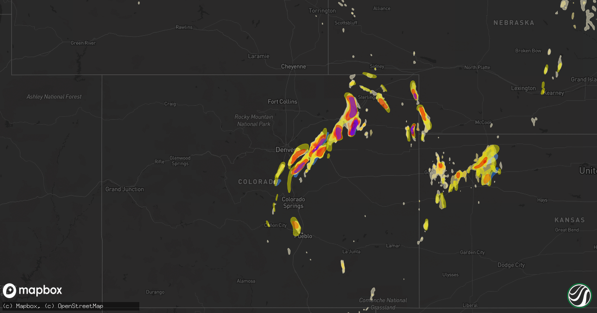
Hail Map on May 10, 2023
Get this storm
May 10 map
$229
one time, instant access
Download today. No call, no setup
Keep the $229
Bought the map and want the full workflow? Apply the entire $229 to a subscription within 7 days. None of it is wasted.
Every map, not just this one
This buys you this map. Subscription and you get every map we run, in the markets you choose from a few cities to whole states to nationwide. Plus real-time alerts the moment a storm fires.
Contact data
Name, contact info, occupancy, even credit band for addresses in the footprint. You go from where it hit to who to call.
Become the source they trust
Unlimited branding weather history reports on demand. You already have the documented answer ready for the property owner, and you are the one who showed up with it.
Property data and RoofTrace estimates
Pull up any address you have got, its value and the exact code rules for that jurisdiction, straight from One Click Code. Then RoofTrace estimates the squares, pitch, and roof value, priced the way you price.
States Impacted by Hail Map on May 10, 2023
Storm reports
Nebraska
| Date | Description |
|---|---|
| 05/10/20235:48 PM CDT | A local report indicates 1.75 inch wind near 14 S LAMAR |
| 05/09/202310:19 PM CDT | Report from mping: half dollar |
| 05/09/202310:03 PM CDT | Report from mping: quarter |
| 05/09/20238:25 PM CDT | Mesonet station up261 0.9 e dix |
| 05/09/20237:56 PM CDT | Source - public report via social media. |
North Dakota
| Date | Description |
|---|---|
| 05/09/20237:25 PM CDT | A local report indicates 1.00 inch wind near 3 W GARSKE |
Arkansas
| Date | Description |
|---|---|
| 05/10/20234:13 PM CDT | Picture on social media shows a large tree and powerlines down across a road. |
| 05/10/20234:06 PM CDT | Picture via social media shows powerlines down. |
| 05/10/20232:45 PM CDT | Corrects previous tstm wnd dmg report from 2 se paragould. Power poles snapped on south second avenue in paragould. Time is radar estimated. |
| 05/10/20232:06 PM CDT | Observed a video of a brief tornado near the intersection of highways 79 and 31 to the north of pine bluff. The tornado in the video lasted approximately 30 seconds and |
| 05/10/20231:05 PM CDT | Corrects previous tornado report from 4 ene warbritton - corrected for time. Observed a video of a brief tornado near the intersection of highways 79 and 31 to the nort |
Tennessee
| Date | Description |
|---|---|
| 05/10/20232:13 PM CDT | One inch hail reported in oakland. Time is radar estimated. |
| 05/10/20231:35 PM CDT | Jamestown rd impassable due to downed trees. |
| 05/10/20231:32 PM CDT | Multiple trees down on highway 59 west in burlison. Time is radar estimated. |
Georgia
| Date | Description |
|---|---|
| 05/10/20236:58 PM CDT | Delayed report. Social media post indicates quarter to golf ball size hail occurred near du pont ga south of high 84.. Estimated hail size is based on provided picture. |
Colorado
| Date | Description |
|---|---|
| 05/10/20236:55 PM CDT | Weak tornado. |
| 05/10/20236:54 PM CDT | Approximate location. Trained spotters reported tornado on the ground. |
| 05/10/20236:51 PM CDT | Delayed report via spotternetwork. |
| 05/10/20236:38 PM CDT | Delayed report via spotternetwork. |
| 05/10/20236:35 PM CDT | Delayed report via spotternetwork. |
| 05/10/20236:34 PM CDT | Corrects previous hail report from 3 ene woodrow. |
| 05/10/20236:32 PM CDT | Delayed report via spotternetwork. |
| 05/10/20236:30 PM CDT | Report from mping: hen egg |
| 05/10/20236:17 PM CDT | Spotter reported hail up to the size of golf balls. There were only a few stones and the hail did not last long. |
| 05/10/20236:05 PM CDT | A local report indicates 1.75 inch wind near 5 N STRASBURG |
| 05/10/20235:56 PM CDT | A local report indicates 1.25 inch wind near 9 N DEER TRAIL |
| 05/10/20235:52 PM CDT | Report from mping: quarter |
| 05/10/20235:50 PM CDT | A local report indicates 2.50 inch wind near STRASBURG |
| 05/10/20235:50 PM CDT | A local report indicates 1.50 inch wind near 2 N FOXFIELD |
| 05/10/20235:48 PM CDT | Corrects previous hail report from 3 e wray. Report via twitter with photo of hail up to 2 inch in diameter east of wray... Co. |
| 05/10/20235:47 PM CDT | A local report indicates 2.75 inch wind near 1 N STRASBURG |
| 05/10/20235:46 PM CDT | Report from mping: quarter |
| 05/10/20235:45 PM CDT | Baseball size hail reported by law enforcement. |
| 05/10/20235:44 PM CDT | Smashed car windshield. |
| 05/10/20235:44 PM CDT | Baseball sized hail smashed car window. |
| 05/10/20235:39 PM CDT | A local report indicates 1.75 inch wind near 3 WSW STRASBURG |
| 05/10/20235:39 PM CDT | Report from mping: half dollar |
| 05/10/20235:34 PM CDT | Pea to quarter size hail and estimated 40-50 mph winds reported by a trained spotter. |
| 05/10/20235:31 PM CDT | A local report indicates 1.25 inch wind near 3 SE AURORA |
| 05/10/20235:30 PM CDT | A local report indicates 1.75 inch wind near 2 NNE FOXFIELD |
| 05/10/20235:23 PM CDT | A local report indicates 2.00 inch wind near 1 NW STRASBURG |
| 05/10/20235:20 PM CDT | A local report indicates 1.00 inch wind near 6 NNE PUEBLO WEST |
| 05/10/20235:20 PM CDT | A local report indicates 1.50 inch wind near 9 SE ARAPAHOE PARK |
| 05/10/20235:17 PM CDT | A local report indicates 1.00 inch wind near 3 NE FOXFIELD |
| 05/10/20235:16 PM CDT | Report from mping: half dollar |
| 05/10/20235:16 PM CDT | Report from mping: quarter |
| 05/10/20235:15 PM CDT | Report from mping: quarter |
| 05/10/20235:13 PM CDT | Report from mping: quarter |
| 05/10/20235:08 PM CDT | Report from mping: golf ball |
| 05/10/20235:07 PM CDT | Report from mping: golf ball |
| 05/10/20235:06 PM CDT | A local report indicates 1.00 inch wind near 2 SE PUEBLO WEST |
| 05/10/20235:05 PM CDT | A local report indicates 1.75 inch wind near 2 ENE FRANKTOWN |
| 05/10/20235:05 PM CDT | A local report indicates 1.25 inch wind near 1 W BUCKLEY AFB |
| 05/10/20235:04 PM CDT | A local report indicates 1.00 inch wind near 3 S BUCKLEY AFB |
| 05/10/20235:02 PM CDT | Report from mping: quarter |
| 05/10/20235:00 PM CDT | A local report indicates 1.50 inch wind near 2 S FOXFIELD |
| 05/10/20235:00 PM CDT | A local report indicates 1.75 inch wind near 1 S DENVER |
| 05/10/20234:59 PM CDT | A local report indicates 1.50 inch wind near 2 NNE FOXFIELD |
| 05/10/20234:59 PM CDT | Report from mping: quarter |
| 05/10/20234:57 PM CDT | Report from mping: ping pong ball |
| 05/10/20234:57 PM CDT | Report from mping: half dollar |
| 05/10/20234:56 PM CDT | A local report indicates 1.00 inch wind near 3 E CHERRY CREEK RESERV |
| 05/10/20234:56 PM CDT | . |
| 05/10/20234:55 PM CDT | Report from mping: ping pong ball |
| 05/10/20234:50 PM CDT | A local report indicates 1.00 inch wind near FRANKTOWN |
| 05/10/20234:41 PM CDT | A local report indicates 1.25 inch wind near 2 NW CASTLEWOOD CANYON |
| 05/10/20234:20 PM CDT | Hail reported in mueller state park... Posted in a picture on twitter. |
| 05/10/20234:03 PM CDT | A local report indicates 1.00 inch wind near PALMER LAKE |
| 05/09/20237:40 PM CDT | A local report indicates 1.00 inch wind near 3 NE PROCTOR |
| 05/09/20237:39 PM CDT | Weak tornado. |
| 05/09/20237:32 PM CDT | A local report indicates a tornado near 6 WSW AKRON |
| 05/09/20237:30 PM CDT | A local report indicates a tornado near 4 S FREMONT BUTTE |
| 05/09/20237:25 PM CDT | A local report indicates 2.80 inch wind near 6 SSW MIDWAY |
| 05/09/20237:25 PM CDT | Corrects previous hail report from 6 ssw midway. |
| 05/09/20237:23 PM CDT | A local report indicates a tornado near 5 S MIDWAY |
| 05/09/20237:21 PM CDT | A local report indicates a tornado near 2 W MIDWAY |
| 05/09/20237:21 PM CDT | Delayed report via spotternetwork. |
| 05/09/20237:20 PM CDT | A local report indicates 2.00 inch wind near 2.5 SSW HILLROSE |
| 05/09/20237:19 PM CDT | Asos station kako akron. |
| 05/09/20237:18 PM CDT | Landspout briefly on ground. |
| 05/09/20237:14 PM CDT | A local report indicates 2.75 inch wind near 3 ENE WOODROW |
| 05/09/20237:13 PM CDT | A local report indicates 4.00 inch wind near 6 ENE GARY |
| 05/09/20237:10 PM CDT | A local report indicates 3.00 inch wind near 7 WSW AKRON |
Missouri
| Date | Description |
|---|---|
| 05/10/20236:49 PM CDT | Large branch of a tree came down and fell a neighboring yard on burford street. Time estimated from radar. |
| 05/10/20236:22 PM CDT | Trained spotter estimated hail sizes ranging from nickel to ping pong. Pictures sent via email. |
| 05/10/20233:38 PM CDT | Large tree split and fell onto roadway at intersection of south avenue and mt vernon street. Time estimated from radar. |
| 05/10/20233:38 PM CDT | Emergency manager sent pictures via email of a bent power pole and a few large trees that fell due to thunderstorm wind gusts. |
Texas
| Date | Description |
|---|---|
| 05/10/20235:04 PM CDT | Hail damaged windshield. |
| 05/10/20232:03 AM CDT | Mesonet station 15 seagraves 1sw. |
| 05/10/20232:02 AM CDT | Gaines county emergency manager shared photos of an overturned irrigation pivot. Location was near us highway 385 just north of seagraves city limits. No other damage w |
| 05/10/20231:02 AM CDT | A local report indicates 67 MPH wind near 1 ENE MORTON |
| 05/09/202311:55 PM CDT | A local report indicates 1.00 inch wind near MULESHOE |
| 05/09/202310:04 PM CDT | A local report indicates 1.00 inch wind near 4 SW VEGA |
| 05/09/20239:27 PM CDT | Light hail accumulation occurring at that time. |
| 05/09/20239:22 PM CDT | A local report indicates 61 MPH wind near 3 SW DALHART |
| 05/09/20237:14 PM CDT | A local report indicates 58 MPH wind near 2 N TEXLINE |
Florida
| Date | Description |
|---|---|
| 05/10/20234:30 PM CDT | Off duty firefighter reported quarter size hail. |
Alabama
| Date | Description |
|---|---|
| 05/10/20236:25 PM CDT | Trees down at the intersection of old rail road bed road and nick davis road in harvest. Report relayed via mcso. |
| 05/10/20233:58 PM CDT | A tree was knocked down at 670 grandview drive. Time estimated by radar. |
| 05/10/20233:56 PM CDT | A tree was knocked down on hatch blvd. At crestline avenue. Time estimated by radar. |
| 05/10/20232:26 PM CDT | A tree was knocked down at 1905 red rock road. |
| 05/10/20232:17 PM CDT | Corrects previous tstm wnd dmg report from 7 ese cherokee. A tree was knocked down at 1905 red rock road. Time estimated by radar. |
Kansas
| Date | Description |
|---|---|
| 05/10/20236:56 PM CDT | Reported via law enforcement. |
| 05/10/20236:25 PM CDT | Hail ranged from pea to quarter in size. |
| 05/10/20235:37 PM CDT | A local report indicates 81 MPH wind near 5 S SELDEN |
| 05/10/20235:34 PM CDT | A local report indicates 66 MPH wind near SELDEN |
| 05/10/20235:34 PM CDT | A local report indicates 67 MPH wind near 5 S SELDEN |
| 05/10/20235:31 PM CDT | A local report indicates 66 MPH wind near 5 S SELDEN |
| 05/10/20235:30 PM CDT | Tornado reported to be just north of town at this time. |
| 05/10/20235:30 PM CDT | Possible tornado damage reported. Outbuilding lost roof... Center pivots overturned and nearby road signs blown down. Time estimated. |
| 05/10/20235:29 PM CDT | Tornado reported 2w and just north of selden. |
| 05/10/20235:15 PM CDT | Trained spotter reports 1 inch hail at rd 5 & rd z in cheyenne county... Ks. |
| 05/10/20235:14 PM CDT | Nickel to quarter size hail. |
| 05/10/20234:40 PM CDT | Delayed social media report with picture of hail ranging from pea to quarters. Time estimated by radar. |
| 05/10/20234:25 PM CDT | Trained spotter reports mostly quarter size hail... Some golf ball size hail and 30 mph winds. |
| 05/10/20234:15 PM CDT | A local report indicates 62 MPH wind near 2 ENE COLBY |
| 05/10/20234:14 PM CDT | Location was road 25 and 72. |
| 05/10/20233:35 PM CDT | Delayed report. Quarter to half dollar sized hail observed. Time estimated. |
| 05/10/20233:08 PM CDT | Hail was mostly dime size but had a few larger quarter size hail reports. |
| 05/09/20238:24 PM CDT | Report from mping: quarter |
| 05/09/20237:30 PM CDT | Pea to quarter sized hail was ongoing at time of the report. Hail was accumulating on the ground. |
| 05/09/20237:27 PM CDT | Torrential rain also observed. |
| 05/09/20237:27 PM CDT | A local report indicates 1.00 inch wind near 7 S SEGUIN |
Iowa
| Date | Description |
|---|---|
| 05/10/202312:42 AM CDT | Social media report with picture next to quarter. Hail size estimated 2 to 2.5 inches. |
| 05/10/202312:40 AM CDT | Report from social media. |
| 05/10/202312:05 AM CDT | Reported via social media with photo. |
| 05/10/202312:01 AM CDT | Report from social media. |
| 05/09/202311:59 PM CDT | A local report indicates 1.00 inch wind near 4 ESE SIOUX CITY |
| 05/09/202311:54 PM CDT | Report from social media. |
New Mexico
| Date | Description |
|---|---|
| 05/10/20236:30 PM CDT | Asos station kcao clayton muni airpark. |
| 05/10/20236:05 PM CDT | Mesonet station sedn5 sedan. |
| 05/10/20235:38 PM CDT | Asos station kcao clayton muni airpark. |
| 05/10/20235:16 PM CDT | Asos station ktcc tucumcari muni airport. |
| 05/10/20233:30 PM CDT | A public weather station measured a 61 mph outflow gust just south of capulin. |
| 05/10/20233:15 PM CDT | Asos station krtn raton crews airport. |
| 05/09/202310:15 PM CDT | Social media post showing measured 1 inch hail. Report and location matched with radar. |
Louisiana
| Date | Description |
|---|---|
| 05/10/20235:01 PM CDT | Power pole snapped. Power outages to kaplan. Times estimated on radar. |
Cities Impacted by Hail Map on May 10, 2023
- George West, TX
- Three Rivers, TX
- Sandia, TX
- Drummonds, TN
- Munford, TN
- Brighton, TN
- Colby, KS
- Monument, KS
- Winona, KS
- Hoxie, KS
- Sedalia, CO
- Conifer, CO
- Wallace, KS
- Edson, KS
- Selden, KS
- Littleton, CO
- Jeffrey City, WY
- Usaf Academy, CO
- Colorado Springs, CO
- Monument, CO
- Palmer Lake, CO
- Woodland Park, CO
- Larkspur, CO
- Louviers, CO
- Castle Rock, CO
- Lone Tree, CO
- Parker, CO
- Williston, FL
- Bronson, FL
- Sharon Springs, KS
- Franktown, CO
- Englewood, CO
- Tribune, KS
- Divide, CO
- Aurora, CO
- Cotopaxi, CO
- Canon City, CO
- Florissant, CO
- Levant, KS
- Elizabeth, CO
- Rexford, KS
- Pecos, TX
- Watkins, CO
- Cripple Creek, CO
- Pueblo, CO
- Hartselle, AL
- Saint Francis, KS
- Denver, CO
- Haigler, NE
- Parks, NE
- Bennett, CO
- Dresden, KS
- Strasburg, CO
- Wray, CO
- Fargo, GA
- Jennings, KS
- Oberlin, KS
- Champion, NE
- Kiowa, CO
- Byers, CO
- Holyoke, CO
- Counce, TN
- Somerville, TN
- New Site, MS
- Booneville, MS
- Tuscumbia, AL
- Waynesboro, TN
- Corinth, MS
- Walnut, MS
- Middleton, TN
- Lutts, TN
- Olivehill, TN
- Savannah, TN
- Saint George, GA
- Glen Saint Mary, FL
- Sanderson, FL
- Grand Junction, TN
- Hickory Valley, TN
- Bells, TN
- Syracuse, KS
- Turrell, AR
- Bassett, AR
- Gilmore, AR
- Lake City, AR
- Redford, MO
- Ellington, MO
- Gem, KS
- Burlison, TN
- Paragould, AR
- Beech Grove, AR
- Bird City, KS
- Henning, TN
- Atoka, TN
- Wilson, AR
- Osceola, AR
- Brewster, KS
- Goodland, KS
- Toone, TN
- Bolivar, TN
- Hornsby, TN
- Henderson, TN
- Medon, TN
- Collinwood, TN
- Leachville, AR
- Monette, AR
- Baker, FL
- Reddick, FL
- Ocala, FL
- Tishomingo, MS
- Bethel Springs, TN
- Finger, TN
- Iuka, MS
- Cherokee, AL
- Pinson, TN
- Moulton, AL
- Mount Hope, AL
- Russellville, AL
- Fort McCoy, FL
- Cleveland, AL
- Hayden, AL
- Ripley, MS
- Lexington, OK
- Atwood, KS
- Macclenny, FL
- Houston, AL
- Burnsville, MS
- Glen, MS
- Oakland, TN
- Ocklawaha, FL
- Shiloh, TN
- Middleburg, FL
- Green Cove Springs, FL
- Covington, TN
- Scotts Hill, TN
- Lexington, TN
- Darden, TN
- Whiteville, TN
- Mason, TN
- Stanton, TN
- Millington, TN
- Arlington, TN
- Tiplersville, MS
- Midland City, AL
- Meridian, MS
- Casper, WY
- O'Kean, AR
- Pocahontas, AR
- Walnut Ridge, AR
- Delaplaine, AR
- Dennis, MS
- Mayo, FL
- Collierville, TN
- Rossville, TN
- Rienzi, MS
- Lincoln, AR
- Prairie Grove, AR
- Eads, TN
- Blanchard, OK
- Amber, OK
- Senath, MO
- Cardwell, MO
- Arbyrd, MO
- Silver Springs, FL
- Palatka, FL
- Holly, CO
- Oakley, KS
- Trenton, FL
- Ramer, TN
- Falkner, MS
- Vernon, CO
- Deer Trail, CO
- Amherst, CO
- Wiggins, CO
- Roggen, CO
- Fort Morgan, CO
- Julesburg, CO
- Yuma, CO
- Eckley, CO
- Woodrow, CO
- Akron, CO
- Lindon, CO
- Norcatur, KS
- Brush, CO
- Otis, CO
- Haxtun, CO
- Fleming, CO
- Roby, MO
- Licking, MO
- Plato, MO
- Du Pont, GA
- Grinnell, KS
- Sterling, CO
- Snyder, CO
- Hillrose, CO
- Merino, CO
- Stoneham, CO
- Sidney, NE
- Peetz, CO
- Iliff, CO
- Padroni, CO
- Nekoma, ND
- Osnabrock, ND
- Fairdale, ND
- Penn, ND
- Churchs Ferry, ND
- Leeds, ND
- Minnewaukan, ND
- Crook, CO
- Ivanhoe, MN
- Arco, MN
- Minneota, MN
- Bard, NM
- Logan, NM
- Devils Lake, ND
- Webster, ND
- Muleshoe, TX
- Farwell, TX
- Hereford, TX
- Friona, TX
- El Dorado, AR
- Sherrill, AR
- Summerfield, TX
- Ravenna, NE
- Hazard, NE
- Loup City, NE
- Rockville, NE
- Vega, TX
- Rogers, NM
- Pep, NM
- Clovis, NM
- Elm Creek, NE
- Kearney, NE
- Amherst, NE
- Mason City, NE
- Litchfield, NE
- Pleasanton, NE
- Portales, NM
- Texico, NM
- Bovina, TX
- Hampden, ND
- Bucyrus, MO
- Brewton, AL
- Barstow, TX
- Lewellen, NE
- Newburg, MO
- Parsons, TN
- Willow Springs, MO
- Starkweather, ND
- Martin, ND
- Esmond, ND
- Edgar Springs, MO
- Live Oak, FL
- Anniston, AL
- Seymour, MO
- Marshfield, MO
- Maddock, ND
- Cusseta, AL
- Gurley, NE
- Crary, ND
- Cullman, AL
- Vinemont, AL
- Indianola, NE
- Elbert, CO
- Marshall, MN
- Ghent, MN
- Neche, ND
- Dix, NE
- Nowata, OK
- Delaware, OK
- Talladega, AL
- Pell City, AL
- Cropwell, AL
- Monahans, TX
- Ragland, AL
- Castleberry, AL
- Evergreen, AL
- Harvest, AL
- Fortson, GA
- Cataula, GA
- Collinsville, MS
- Odenville, AL
- Alpine, AL
- Wing, AL
- Pritchett, CO
- Oneonta, AL
- Locust Fork, AL
- Naylor, GA
- Addison, AL
- Lafayette, AL
- Fort Scott, KS
- Sedan, NM
- Range, AL
- Grenville, NM
- Grainfield, KS
- San Jon, NM
- Big Springs, NE
- Haleyville, AL
- Double Springs, AL
- Osceola, MO
- Mountain Grove, MO
- Lynchburg, MO
- Westcliffe, CO
- Hartville, MO
- Hohenwald, TN
- Lawrenceburg, TN
- Harvey, ND
- Culbertson, NE
- Weir, MS
- Ackerman, MS
- Vredenburgh, AL
- Franklin, AL
- Whatley, AL
- Frisco City, AL
- Arcadia, NE
- Coffeeville, AL
- Orleans, NE
- Oxford, NE
- Ozark, AL
- Fort Leonard Wood, MO
- Clayton, NM
- Grandfalls, TX
- Danville, AL
- Decatur, AL
- Duke, MO
- Trinity, AL
- Falkville, AL
- Fountain, CO
- Athens, AL
- Falcon, MO
- Cheyenne Wells, CO
- Success, MO
- Sioux City, IA
- Hinton, IA
- Merrill, IA
- Le Mars, IA
- Oyens, IA
- Remsen, IA
- Larchwood, IA
- Rock Rapids, IA
- Verdigre, NE
- Orange City, IA
- Alton, IA
- Clearwater, NE
- Ewing, NE
- Mitchell, NE
- Doon, IA
- Harrison, NE
- Weskan, KS
- Rock Valley, IA
- Inwood, IA
- Springfield, MN
- Sanborn, MN
- Good Thunder, MN
- Mapleton, MN
- Sudan, TX
- Maple, TX
- Causey, NM
- Elgin, NE
- Chambers, NE
- Petersburg, NE
- Albion, NE
- Inman, NE
- Page, NE
- Center, NE
- Glendo, WY
- Trinidad, CO
- Oakdale, NE
- Neligh, NE
- Emelle, AL
- Boligee, AL
- Eutaw, AL
- Aliceville, AL
- Epes, AL
- Gainesville, AL
- Nacogdoches, TX
- Denver City, TX
- South Sioux City, NE
- Lisman, AL
- Morton, TX
- Gering, NE
- Butler, AL
- Toxey, AL
- Plains, TX
- Orchard, NE
- Oneill, NE
- Bartlett, NE
- Amboy, MN
- Tatum, NM
- Elida, NM
- Ashton, NE
- Lovington, NM
- Brownfield, TX
- Letohatchee, AL
- Hope Hull, AL
- Hemingford, NE
- Roswell, NM
- Roseau, MN
- McDonald, KS
- Spalding, NE
- Knoxville, AL
- Lynd, MN
- Wheatland, WY
- Adrian, TX
- Levelland, TX
- Enochs, TX
- Whiteface, TX
- Amelia, NE
- Dimmitt, TX
- Arapahoe, CO
- Seagraves, TX
- Seminole, TX
- Ericson, NE
- Marsland, NE
- Crawford, NE
- Taunton, MN
- Volin, SD
- Irene, SD
- Mission Hill, SD
- New Richland, MN
- Wells, MN
- Hartland, MN
- Paducah, TX
- Burwell, NE
- Lamesa, TX
- Ackerly, TX
- Garrison, TX
- Timpson, TX
- Niobrara, NE
- Bloomfield, NE
- Floydada, TX
- Matador, TX
- Lenorah, TX
- Tahoka, TX
- Welch, TX
- Loop, TX
- Lubbock, TX
- Brunswick, NE
- Mount Enterprise, TX
- Scotia, NE
- Greeley, NE
- Osmond, NE
- Pierce, NE
- Childress, TX
- Viborg, SD
- Winnebago, MN
- Janesville, MN
- Pemberton, MN
- Ropesville, TX
- Wolfforth, TX
- Plainview, NE
- Meadow Grove, NE
- Beulah, CO
- Dickens, TX
- Memphis, TX
- Royal, NE
- Rye, CO
- Mankato, MN
- Clarendon, TX
- Gary, TX
- Tenaha, TX
- Hedley, TX
- Quanah, TX
- Chillicothe, TX
- Seymour, TX
- Old Glory, TX
- Hollis, OK
- Gould, OK
- Wellington, TX
- Dodson, TX
- Crowell, TX
- Knox City, TX
- O'Brien, TX
- Lakeview, TX
- Rule, TX
- Goree, TX
- Vernon, TX
- Eldorado, OK