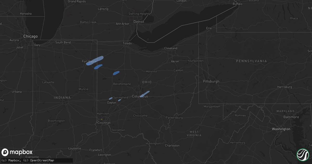
Hail Map in Ohio on May 10, 2020
Get this storm
May 10 map
$229
one time, instant access
Download today. No call, no setup
Keep the $229
Bought the map and want the full workflow? Apply the entire $229 to a subscription within 7 days. None of it is wasted.
Every map, not just this one
This buys you this map. Subscription and you get every map we run, in the markets you choose from a few cities to whole states to nationwide. Plus real-time alerts the moment a storm fires.
Contact data
Name, contact info, occupancy, even credit band for addresses in the footprint. You go from where it hit to who to call.
Become the source they trust
Unlimited branding weather history reports on demand. You already have the documented answer ready for the property owner, and you are the one who showed up with it.
Property data and RoofTrace estimates
Pull up any address you have got, its value and the exact code rules for that jurisdiction, straight from One Click Code. Then RoofTrace estimates the squares, pitch, and roof value, priced the way you price.
Storm reports in Ohio
Ohio
| Date | Description |
|---|---|
| 05/10/20205:53 PM CDT | Power lines down wind gust of 64mph. |
| 05/10/20205:41 PM CDT | Snapped tree near 7 mile road... With report of road being blocked. Time estimated based on radar. |
| 05/10/20205:40 PM CDT | Large trees blown over and uprooted near corner of hardesty and tuscarawas. Time estimated based on radar. |
| 05/10/20205:39 PM CDT | Report and pictures of downed trees in northwest new philadelphia. Time and located estimated. |
| 05/10/20205:15 PM CDT | A few trees down...power lines down near coshocton and west lafayette. |
| 05/10/20205:10 PM CDT | Two trees uprooted |
| 05/10/20204:40 PM CDT | Barn leveled on smith chapel road. Numerous trees snapped on pinewood trail road. Time estimated from radar. |
| 05/10/20204:30 PM CDT | Large limb down from tree. |
| 05/10/20204:19 PM CDT | 1-inch tree limbs down... Shingles blown off roof. Report from mping. |
| 05/10/20204:17 PM CDT | Very large 4 foot diameter tree fell onto house. Photos posted on social media. |
| 05/10/20204:15 PM CDT | 30 ft pine trees down on 3000 block of johnstown-alexandria road. Time estimated from radar. |
| 05/10/20204:05 PM CDT | Trees uprooted. |
| 05/10/20204:05 PM CDT | Treee down on darby creek road. Time estimated from radar. |
| 05/10/20204:05 PM CDT | Several large but shallow-rooted trees downed at havens corner and surrey drive. Photos posted on social media. Time estimated from radar. |
| 05/10/20204:03 PM CDT | Tree downed near groveport pike. |
| 05/10/20204:00 PM CDT | A local report indicates 64 MPH wind near KCMH JOHN GLENN APT |
| 05/10/20204:00 PM CDT | Several large branches fell on power lines in north remington road area. Time estimated from radar. |
| 05/10/20204:00 PM CDT | Very large branches off of two healthy trees snapped on marjoram drive. Photo sent to office. Time estimated from radar. |
| 05/10/20203:58 PM CDT | Numerous trees down near state route 16 and hampton road intersection. Photos posted on social media. Time estimated from radar. |
| 05/10/20203:56 PM CDT | Large limbs down on hall road. Photo posted on social media. Time estimated from radar. |
| 05/10/20203:56 PM CDT | Large branches down across road at northtowne and fleetwood. Photo posted on social media. Time estimated from radar. |
| 05/10/20203:54 PM CDT | Two foot diameter tree downed in glen echo ravine near indianola avenue. |
| 05/10/20203:50 PM CDT | Photos posted on social media of limbs down in franklinton. Time estimated from radar. |
| 05/10/20203:48 PM CDT | *delayed report* tree snapped on wilson street. |
| 05/10/20203:46 PM CDT | A local report indicates 1.00 inch wind near 5 W FINNEYTOWN |
| 05/10/20203:45 PM CDT | Corrects previous lsr: *delayed report* two trees down. |
| 05/10/20203:42 PM CDT | Numerous trees fell into power poles between london and west jefferson. Time estimated from radar. |
| 05/10/20203:35 PM CDT | A branch from a bradford pear down. Photo posted on social media. Time estimated from radar. |
| 05/10/20203:34 PM CDT | Tree down on vehicle |
| 05/10/20203:23 PM CDT | Trees fell into power lines at sr-729 and marchant-lutrell road. Time estimated from radar. |
| 05/10/20203:15 PM CDT | Large tree snapped along w. Main street by clinton memorial hospital. Time estimated by radar. |
| 05/10/20203:15 PM CDT | Small limbs down on us-22 just west of wilmington. Time estimated from radar. |
| 05/10/20203:15 PM CDT | A couple trees were blown down across the county and partially blocking roads. Time was estimated by radar. |
| 05/10/20203:09 PM CDT | A barn had part of its roof removed on paullin road. |
| 05/10/20203:09 PM CDT | Barn leveled on watkins road. Time estimated from radar. |
| 05/10/20203:00 PM CDT | *delayed report* siding ripped off of a structure. |
| 05/10/20203:00 PM CDT | The entire roof was blown off on the northside of sonny jacks bar in downtown new riegel. There were also a few trees blown down across the country blocking roads. Time |
| 05/10/20203:00 PM CDT | A local report indicates 59 MPH wind near KSGH SPRINGFIELD APT |
| 05/10/20202:57 PM CDT | Large tree down in pond. |
| 05/10/20202:53 PM CDT | Large tree limb down |
| 05/10/20202:48 PM CDT | Large tree limb down. Photo sent to office. |
| 05/10/20202:46 PM CDT | Tree downed on a house. |
| 05/10/20202:45 PM CDT | Several large tree limbs were blown down in waterville. Time was estimated by radar. |
| 05/10/20202:45 PM CDT | *delayed report* tree on house. |
| 05/10/20202:40 PM CDT | Several large branches from pine trees down. Photos sent to office. Time estimated from radar. |
| 05/10/20202:40 PM CDT | Large tree down across road. Photo sent to office. Time estimated from radar. |
| 05/10/20202:38 PM CDT | One small tree snapped. A large branch broken off another tree. |
| 05/10/20202:38 PM CDT | Large tree down on stonebridge road. Time estimated from radar. |
| 05/10/20202:26 PM CDT | A local report indicates 58 MPH wind near KDAY DAYTON COX APT |
| 05/10/20202:26 PM CDT | Large tree down and several large branches down. Photos sent to office. Time estimated from radar. |
| 05/10/20202:02 PM CDT | A local report indicates 60 MPH wind near 3 NE YODER |
| 05/10/20201:55 PM CDT | Large tree broken in half. |
| 05/10/20201:54 PM CDT | Back of barn damaged. Fire department is going to investigate. Time estimated from radar. |
| 05/10/20201:49 PM CDT | Witnessed a large tree go down during the storm. Estimated the diameter of the tree was about 2 to 2.5 ft... But the health of the tree is unknown. |
| 05/10/20201:33 PM CDT | Two maple trees 2 1/2 feet in diameter uprooted. Shingles off nearby roofs. Time estimated by radar. |
| 05/10/20201:30 PM CDT | Report relayed by the emergency manager... Time estimated by radar. |
| 05/10/20201:29 PM CDT | A local report indicates 61 MPH wind near 4 NE ANTWERP |
| 05/10/20204:24 AM CDT | At 924 PM EDT, a severe thunderstorm was located over Sandyville, or 7 miles north of Ripley, moving east at 55 mph. HAZARD...60 mph wind gusts and half dollar size hail. SOURCE...Radar indicated. IMPACT...Hail damage to vehicles is expected. Expect wind damage to roofs, siding, and trees. Locations impacted include... Ripley, Elizabeth, Grantsville, Ravenswood, Sandyville, Reedy, Cherry, Peewee, Mount Zion, Palestine, Lucille, Creston, Morristown, Brohard, Macfarlan, Annamoriah, Leroy, Munday and Evans.This includes Interstate 77 in West Virginia between mile markers 138and 157. |
| 05/10/20203:55 AM CDT | At 855 PM EDT, a severe thunderstorm was located over Jackson, moving east at 40 mph. HAZARD...60 mph wind gusts and quarter size hail. SOURCE...Trained weather spotters. IMPACT...Hail damage to vehicles is expected. Expect wind damage to roofs, siding, and trees. Locations impacted include... Jackson, Wellston, Rutland, Hamden, Coalton, Wilkesville, Dyesville, Salem Center, Radcliffe, Harrisonville, Dexter and Carpenter. |
| 05/10/20201:18 AM CDT | At 618 PM EDT, severe thunderstorms were located along a line extending from near Sardinia to near Higginsport, moving east at 35 mph. HAZARD...60 mph wind gusts and quarter size hail. SOURCE...Radar indicated. IMPACT...Minor hail damage to vehicles is possible. Expect wind damage to trees and power lines. Locations impacted include... Georgetown, West Union, Winchester, Sardinia, Seaman, Emerald, Decatur, Russellville, Hamersville, Higginsport, Cherry Fork, Redoak, Lake Waynoka, May Hill, Feesburg, Fincastle, State Route 32 at US Route 62 and New Hope. |
| 05/10/20201:09 AM CDT | At 609 PM EDT, a severe thunderstorm was located near West Lafayette, or near Coshocton, moving east at 45 mph. HAZARD...Wind gusts to 60 mph and quarter-size hail. SOURCE...Radar. IMPACT...Minor hail damage to vehicles is possible. Expect wind damage to trees and power lines, resulting in some power outages. Locations impacted include... New Philadelphia... Dover... Cambridge... Uhrichsville... Newcomerstown... Dennison... Strasburg... New Concord... Byesville... West Lafayette... Sugarcreek... Gnadenhutten...This includes the following highways... Interstate 70 in Ohio between mile markers 168 and 194. Interstate 77 in Ohio between mile markers 41 and 89. |
| 05/10/20201:07 AM CDT | At 607 PM EDT, a severe thunderstorm was located near Williamsburg, moving east at 40 mph. HAZARD...60 mph wind gusts and half dollar size hail. SOURCE...Radar indicated. IMPACT...Minor hail damage to vehicles is possible. Expect wind damage to trees and power lines. Locations impacted include... Hillsboro, Greenfield, Mount Orab, Leesburg, Marshall, Rocky Fork Point, Highland Holiday, Russell, New Market, Sinking Spring, Rocky Fork Lake, Chasetown, Danville in Highland County, Greenbush, Samantha, Rainsboro, Buford, Paint Creek State Park, State Route 32 at US Route 68 and Berrysville. |
| 05/10/202012:52 AM CDT | At 552 PM EDT, a severe thunderstorm was located near Williamsburg, moving northeast at 35 mph. HAZARD...60 mph wind gusts and quarter size hail. SOURCE...Radar indicated. IMPACT...Minor hail damage to vehicles is possible. Expect wind damage to trees and power lines. Locations impacted include... Amelia, Mount Orab, Williamsburg, Batavia, Lynchburg, Russell, Owensville, Newtonsville, Fayetteville, St. Martin, Chasetown, Clermont County Airport, Greenbush, East Fork State Park, Edenton and Lake Lorelei. |
| 05/10/202012:38 AM CDT | At 537 PM EDT, a severe thunderstorm was located 7 miles north of Hanover, or 10 miles northeast of Newark, moving east at 30 mph. HAZARD...Wind gusts to 60 mph and quarter-size hail. SOURCE...Radar. IMPACT...Minor hail damage to vehicles is possible. Expect wind damage to trees and power lines, resulting in some power outages. Locations impacted include... Zanesville... Coshocton... South Zanesville... North Zanesville... Dresden... Frazeysburg... Philo... Warsaw... Pleasant Grove... Conesville... Gratiot... Fultonham...This includes Interstate 70 in Ohio near mile marker 143, andbetween mile markers 145 and 167. |
| 05/10/202012:32 AM CDT | At 531 PM EDT, severe thunderstorms were located along a line extending from near Heath to Pleasantville, moving east at 50 mph. HAZARD...60 mph wind gusts. SOURCE...Radar indicated. IMPACT...Expect damage to roofs, siding, and trees. Locations impacted include... New Lexington, Somerset, Perry State Forest, Crooksville, Thornville, Junction City and Glenford. |
| 05/10/202012:23 AM CDT | At 523 PM EDT, a severe thunderstorm was located over Heath, moving east at 40 mph. HAZARD...70 mph wind gusts. SOURCE...Radar indicated. IMPACT...Expect considerable tree damage. Damage is likely to mobile homes, roofs, and outbuildings. Locations impacted include... Newark, Hanover, Marne, Gratiot, Toboso, Fallsburg, Purity and Brownsville.This includes I-70 in Ohio between mile markers 136 and 142, and nearmile marker 144. |
| 05/09/202011:58 PM CDT | At 458 PM EDT, severe thunderstorms were located along a line extending from near Sandusky to near New London, moving east at 40 mph. HAZARD...60 mph wind gusts. SOURCE...Radar indicated. IMPACT...Expect damage to trees and power lines. Locations impacted include... Lorain, Elyria, Sandusky, Norwalk, Western Vermilion, Vermilion, North Ridgeville, Amherst, Grafton, Wellington, New London, Northern Milan, Milan, Wakeman, Sheffield Lake, Eaton, Oberlin, Sheffield, Lagrange and Penfield. |
| 05/09/202011:56 PM CDT | At 455 PM EDT, severe thunderstorms were located along a line extending from near Sunbury to 6 miles north of South Bloomfield, moving northeast at 50 mph. HAZARD...60 mph wind gusts. SOURCE...Radar indicated. IMPACT...Expect damage to trees and power lines. Locations impacted include... Newark, Lancaster, Reynoldsburg, Pickerington, Heath, Granville, Pataskala, Canal Winchester, Johnstown, Baltimore, Buckeye Lake, Hebron, Millersport, Pleasantville, Harbor Hills, Granville South, Fairfield Beach, Beechwood Trails, Summit Station and Thornport.This includes I-70 in Ohio between mile markers 112 and 136. |
| 05/09/202011:34 PM CDT | At 434 PM EDT, severe thunderstorms were located along a line extending from near New California to 6 miles northwest of Mount Sterling, moving east at 30 mph. HAZARD...60 mph wind gusts. SOURCE...Radar indicated. IMPACT...Expect damage to trees and power lines. Locations impacted include... Columbus, Dublin, Westerville, Reynoldsburg, Grove City, Delaware, Upper Arlington, Gahanna, Hilliard, Worthington, Bexley, Powell, Canal Winchester, Groveport, Sunbury, Plain City, Ashville, South Bloomfield, Minerva Park and New California.This includes the following Interstates... I-70 in Ohio between mile markers 93 and 111. I-71 in Ohio between mile markers 89 and 138. |
| 05/09/202011:22 PM CDT | At 422 PM EDT, severe thunderstorms were located along a line extending from near Jeffersonville to Lynchburg, moving east at 35 mph. HAZARD...60 mph wind gusts. SOURCE...Radar indicated. IMPACT...Expect damage to trees and power lines. Locations impacted include... Washington Court House, Greenfield, Leesburg, Jeffersonville, Williamsport, Bloomingburg, New Holland, Staunton, Good Hope, Frankfort, Clarksburg, Highland, Darbyville, South Salem, Deer Creek Lake, Interstate 71 at State Route 38, East Monroe, Austin, Madison Mills and Rock Mills.This includes I-71 in Ohio between mile markers 68 and 75. |
| 05/09/202011:14 PM CDT | At 413 PM EDT, severe thunderstorms were located along a line extending from near Oak Harbor to near Bloomville, moving east at 40 mph. HAZARD...60 mph wind gusts. SOURCE...Radar indicated. IMPACT...Expect damage to trees and power lines. Locations impacted include... Sandusky, Tiffin, Norwalk, Fremont, Port Clinton, Bellevue, Clyde, Willard, Oak Harbor, Plymouth, Green Springs, Northern Milan, Milan, Bloomville, Castalia, Ballville, Catawba Island, Greenwich, Monroeville and Marblehead. |
| 05/09/202011:05 PM CDT | At 405 PM EDT, severe thunderstorms were located along a line extending from near Mechanicsburg to near South Charleston, moving east at 45 mph. HAZARD...60 mph wind gusts. SOURCE...Radar indicated. IMPACT...Expect damage to trees and power lines. Locations impacted include... Columbus, Dublin, Upper Arlington, Hilliard, London, Jefferson, Plain City, West Jefferson, Mount Sterling, Choctaw Lake, Lake Darby, Lafayette, South Solon, Midway, Newport, Chenoweth, Rosedale, Resaca, Georgesville and Madison Lake.This includes the following Interstates... I-70 in Ohio between mile markers 71 and 92. I-71 in Ohio between mile markers 76 and 88. |
| 05/09/202010:57 PM CDT | At 357 PM EDT, severe thunderstorms were located along a line extending from near Fairborn to near Batavia, moving northeast at 45 mph. HAZARD...60 mph wind gusts. SOURCE...Radar indicated. IMPACT...Expect damage to trees and power lines. Locations impacted include... Beavercreek, Fairborn, Xenia, Lebanon, Wilmington, Bellbrook, Blanchester, Yellow Springs, Wright-Patterson Afb, Cedarville, Waynesville, Sabina, Jamestown, New Vienna, Jeffersonville, Morrow, Wilberforce, New Jasper, Woodville and Maineville.This includes I-71 in Ohio between mile markers 31 and 72. |
| 05/09/202010:30 PM CDT | At 330 PM EDT, severe thunderstorms were located along a line extending from near Sidney to near Northridge, moving east at 55 mph. HAZARD...60 mph wind gusts. SOURCE...Radar indicated. IMPACT...Expect damage to trees and power lines. Locations impacted include... Dayton, Springfield, Huber Heights, Fairborn, Troy, Sidney, Vandalia, Bellefontaine, Urbana, Tipp City, New Carlisle, Yellow Springs, Wright-Patterson Afb, Northridge, Enon, St. Paris, West Liberty, South Charleston, Mechanicsburg and North Lewisburg.This includes the following Interstates... I-70 in Ohio between mile markers 33 and 70. I-75 in Ohio between mile markers 56 and 69. |
| 05/09/202010:25 PM CDT | At 325 PM EDT, severe thunderstorms were located along a line extending from near Trotwood to near Hamilton, moving northeast at 40 mph. HAZARD...60 mph wind gusts and penny size hail. SOURCE...Radar indicated. IMPACT...Expect damage to trees and power lines. Locations impacted include... Dayton, Hamilton, Kettering, Middletown, Beavercreek, Fairborn, Mason, Xenia, Trotwood, Miamisburg, Lebanon, Springboro, Monroe, Trenton, Franklin, Bellbrook, Moraine, Carlisle, Oakwood and South Middletown.This includes the following Interstates... I-71 in Ohio between mile markers 26 and 41. I-75 in Ohio between mile markers 24 and 55. |
| 05/09/202010:20 PM CDT | At 320 PM EDT, severe thunderstorms were located along a line extending from 8 miles south of Adrian to near Belle Center, moving east at 40 mph. HAZARD...60 mph wind gusts. SOURCE...Radar indicated. IMPACT...Expect damage to trees and power lines. Locations impacted include... Toledo, Bowling Green, Tiffin, Fremont, Fostoria, Perrysburg, Oregon, Sylvania, Rossford, Waterville, Northwood, Whitehouse, North Baltimore, Oak Harbor, Gibsonburg, Genoa, Woodville, Holland, Weston and Elmore. |
| 05/09/202010:18 PM CDT | At 318 PM EDT, severe thunderstorms were located along a line extending from near Morenci to Lakeview, moving east at 40 mph. HAZARD...60 mph wind gusts. SOURCE...Radar indicated. IMPACT...Expect damage to trees and power lines. Locations impacted include... Findlay, Marion, Tiffin, Fostoria, Upper Sandusky, Bluffton, North Baltimore, McComb, Forest, Arlington, Prospect, Sycamore, La Rue, Arcadia, Rawson, Morral, Vanlue, Waldo, Van Buren and New Riegel. |
| 05/09/202010:11 PM CDT | At 311 PM EDT, severe thunderstorms were located along a line extending from 6 miles east of Lima to near Anna, moving east at 50 mph. HAZARD...60 mph wind gusts. SOURCE...Radar indicated. IMPACT...Expect damage to trees and power lines. Locations impacted include... Bellefontaine, Wapakoneta, Kenton, Ada, Fort Shawnee, Cridersville, Anna, Jackson Center, Forest, Russells Point, Botkins, Lakeview, Dunkirk, Alger, Waynesfield, Belle Center, West Mansfield, Chippewa Park, Northwood and Blanchard.This includes I-75 in Ohio between mile markers 96 and 118. |
| 05/09/20209:54 PM CDT | At 253 PM EDT, severe thunderstorms were located along a line extending from near Versailles to near New Paris, moving east at 45 mph. HAZARD...60 mph wind gusts and penny size hail. SOURCE...Radar indicated. IMPACT...Expect damage to trees and power lines. Locations impacted include... Dayton, Huber Heights, Troy, Trotwood, Sidney, Piqua, Vandalia, Englewood, Greenville, Tipp City, West Milton, Versailles, Covington, Arcanum, Newport, Bradford, Lewisburg, New Paris, Pleasant Hill and Ansonia.This includes the following Interstates... I-70 in Ohio between mile markers 2 and 40. I-75 in Ohio between mile markers 56 and 95. |
| 05/09/20209:52 PM CDT | At 251 PM EDT, severe thunderstorms were located along a line extending from near Richmond to near Brookville, moving northeast at 60 mph. HAZARD...60 mph wind gusts and penny size hail. SOURCE...Radar indicated. IMPACT...Expect damage to trees and power lines. Locations impacted include... Dayton, Hamilton, Richmond, Trotwood, Oxford, Trenton, Eaton, Brookville, Liberty, Camden, West Alexandria, Gratis, Seven Mile, West College Corner, Darrtown, Williamsdale, Salem, Germantown, New Lebanon and Reily. |
| 05/09/20209:46 PM CDT | At 245 PM EDT, severe thunderstorms were located along a line extending from near Ottoville to near Elida to near St. Marys to 6 miles west of Minster, moving northeast at 55 mph. HAZARD...60 mph wind gusts. SOURCE...Radar indicated. IMPACT...Expect damage to roofs, siding, and trees. Locations impacted include... Lima, Van Wert, Delphos, Ottawa, Bluffton, Fort Shawnee, Spencerville, Columbus Grove, Leipsic, Elida, Deshler, Kalida, Pandora, Glandorf, Ottoville, Ohio City, Spencerville In Allen County, Middle Point, Cairo and Fort Jennings.This includes Interstate 75 between mile markers 119 and 141. |
| 05/09/20209:37 PM CDT | At 236 PM EDT, severe thunderstorms were located along a line extending from near Union City to near Cambridge City, moving northeast at 65 mph. HAZARD...60 mph wind gusts and penny size hail. SOURCE...Radar indicated. IMPACT...Expect damage to trees and power lines. Locations impacted include... Richmond, Greenville, Centerville, Cambridge City, Versailles, Covington, Arcanum, Newport, Bradford, Lewisburg, Union City, New Paris, Ansonia, New Madison, Fountain City, Dublin, Webster, Wayne Lakes, Russia and Gettysburg.This includes the following Interstates... I-70 in Indiana between mile markers 136 and 156. I-70 in Ohio between mile markers 0 and 15. |
| 05/09/20209:08 PM CDT | At 207 PM EDT, severe thunderstorms were located along a line extending from Grabill to near Monroeville to near Decatur, moving northeast at 40 mph. HAZARD...60 mph wind gusts. SOURCE...Radar indicated. IMPACT...Expect damage to roofs, siding, and trees. Locations impacted include... Fort Wayne, Defiance, New Haven, Van Wert, Decatur, Hicksville, Paulding, Antwerp, Woodburn, Monroeville, Payne, Convoy, Grabill, Ottoville, St. Joe, Oakwood, Leo-cedarville, Middlebury, Farmer and Dixon.This includes the following highways... Interstate 469 between mile markers 19 and 30. Interstate 69 in Indiana between mile markers 317 and 320. |
| 05/09/20208:50 PM CDT | At 149 PM EDT, a severe thunderstorm was located 8 miles northwest of Ossian, moving northeast at 45 mph. HAZARD...70 mph wind gusts. SOURCE...Radar indicated. IMPACT...Expect considerable tree damage. Damage is likely to mobile homes, roofs, and outbuildings. Locations impacted include... Fort Wayne, Huntington, New Haven, Bluffton, Decatur, Ossian, Huntertown, Markle, Aboite, Middletown, Roanoke, Warren, Preble, Zanesville, Uniondale, Laud, Yoder, Murray, Peterson and Raber.This includes the following highways... Interstate 469 between mile markers 0 and 20, and between milemarkers 28 and 30. Interstate 69 in Indiana between mile markers 278 and 319. |
| 05/09/20207:55 PM CDT | Quarter size hail happening at time of call... Some stones possibly larger. |
All States Impacted by Hail Map on May 10, 2020
Cities Impacted by Hail Map on May 10, 2020
- Tucumcari, NM
- Solano, NM
- Wagon Mound, NM
- Conchas Dam, NM
- Mcalister, NM
- Melrose, NM
- Trementina, NM
- Cincinnati, OH
- Harlan, IN
- Hoagland, IN
- Monroeville, IN
- Cecil, OH
- Fort Wayne, IN
- Payne, OH
- New Haven, IN
- Yoder, IN
- Paulding, OH
- Antwerp, OH
- Woodburn, IN
- Van Wert, OH
- Scott, OH
- Ohio City, OH
- Convoy, OH
- Decatur, IN
- Harrod, OH
- Ada, OH
- Alger, OH
- Lima, OH
- Lafayette, OH
- Wapakoneta, OH
- Vandalia, OH
- Englewood, OH
- Dayton, OH
- Tipp City, OH
- Springfield, OH
- Yellow Springs, OH
- Johnstown, OH
- New Albany, OH
- Blacklick, OH
- Pataskala, OH
- Alexandria, OH
- Columbus, OH
- Reynoldsburg, OH


