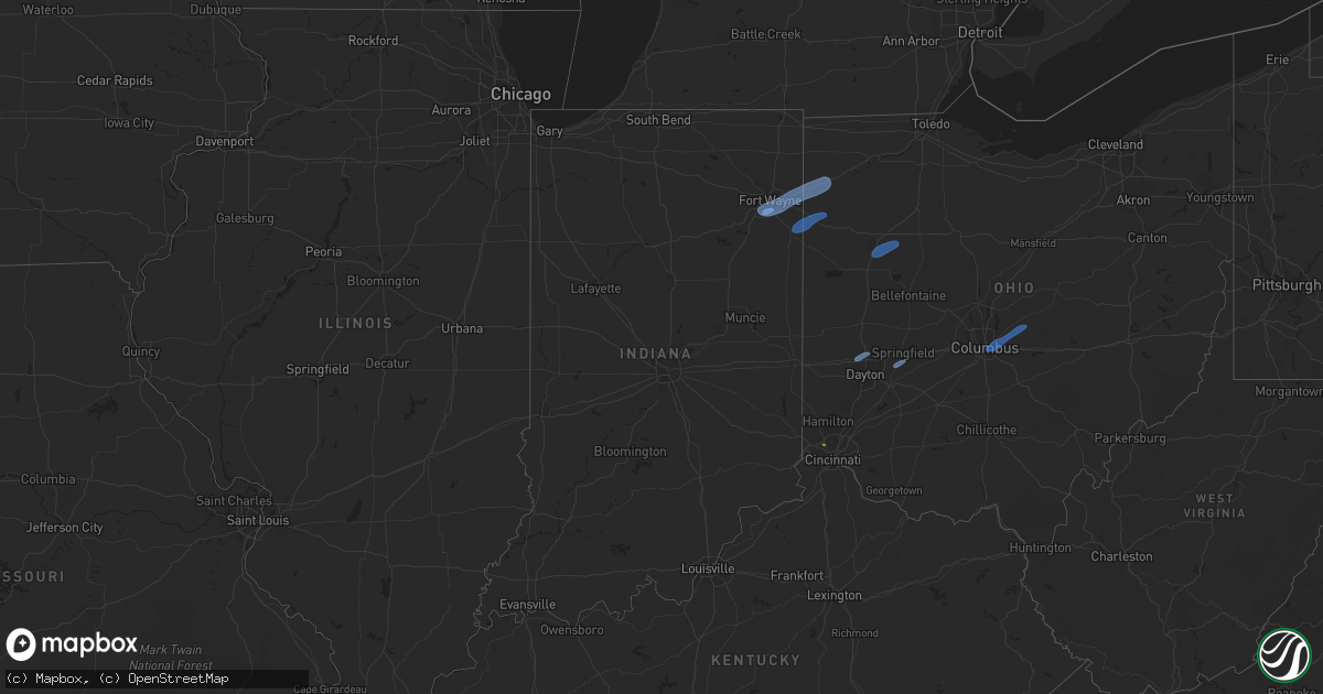
Hail Map in Indiana on May 10, 2020
Get this storm
May 10 map
$229
one time, instant access
Download today. No call, no setup
Keep the $229
Bought the map and want the full workflow? Apply the entire $229 to a subscription within 7 days. None of it is wasted.
Every map, not just this one
This buys you this map. Subscription and you get every map we run, in the markets you choose from a few cities to whole states to nationwide. Plus real-time alerts the moment a storm fires.
Contact data
Name, contact info, occupancy, even credit band for addresses in the footprint. You go from where it hit to who to call.
Become the source they trust
Unlimited branding weather history reports on demand. You already have the documented answer ready for the property owner, and you are the one who showed up with it.
Property data and RoofTrace estimates
Pull up any address you have got, its value and the exact code rules for that jurisdiction, straight from One Click Code. Then RoofTrace estimates the squares, pitch, and roof value, priced the way you price.
Storm reports in Indiana
Indiana
| Date | Description |
|---|---|
| 05/10/20201:13 PM CDT | Delayed report of a tree downed on a garage on 9th street in auburn... In. No information on the size or health of the tree. No injuries reported. |
| 05/10/20201:10 PM CDT | 15-20 foot tree downed at arcadia ct. And hoagland ave. Tree partially blocking arcardia ct. |
| 05/10/202012:50 PM CDT | Large tree down. |
| 05/10/202012:40 PM CDT | 2 power poles snapped. |
| 05/10/202012:40 PM CDT | Wires downed... Trees into hoses. Primarily east side of fort wayne into new haven. |
| 05/10/202012:37 PM CDT | Corrects previous report of the asos observation at the fort wayne airport. |
| 05/09/202010:27 PM CDT | At 327 PM EDT, severe thunderstorms were located along a line extending from Burlington to 7 miles southeast of Kentucky Speedway, moving northeast at 65 mph. HAZARD...60 mph wind gusts. SOURCE...Radar indicated. IMPACT...Expect damage to trees and power lines. Locations impacted include... Cincinnati, Covington, Florence, Independence, Erlanger, Fort Thomas, Newport, Edgewood, Alexandria, Elsmere, Fort Mitchell, Villa Hills, Highland Heights, Taylor Mill, Bellevue, Fort Wright, Southgate, Crescent Springs, Walton and Crestview Hills.This includes the following Interstates... I-71 in Kentucky between mile markers 61 and 77. I-75 in Kentucky between mile markers 159 and 191. |
| 05/09/202010:05 PM CDT | At 305 PM EDT, severe thunderstorms were located along a line extending from 6 miles north of Florence to 7 miles southeast of Carrollton, moving east at 45 mph. HAZARD...60 mph wind gusts and penny size hail. SOURCE...Radar indicated. IMPACT...Expect damage to trees and power lines. Locations impacted include... Walton, Crittenden, Dry Ridge, Vevay, Warsaw, Florence, Kentucky Speedway, Glencoe, Ghent, Sanders, Sparta, Patriot, Worthville, Center Square, Ryle, Interstate 71 at Mile Marker 52, Northcutt, Interstate 71 at US Route 127, Steele Bottom and Bracht.This includes the following Interstates... I-71 in Kentucky between mile markers 47 and 74. I-75 in Kentucky between mile markers 159 and 171. |
| 05/09/202010:00 PM CDT | At 300 PM EDT, a severe thunderstorm was located near Rising Sun, moving east at 45 mph. HAZARD...60 mph wind gusts. SOURCE...Radar indicated. IMPACT...Expect damage to trees and power lines. Locations impacted include... Covington, Florence, Independence, Erlanger, Edgewood, Elsmere, Fort Mitchell, Villa Hills, Taylor Mill, Fort Wright, Crescent Springs, Walton, Crestview Hills, Park Hills, Lakeside Park, Rising Sun, Oakbrook, Burlington, Union and French.This includes the following Interstates... I-71 in Kentucky between mile markers 75 and 77. I-75 in Kentucky between mile markers 172 and 190. |
All States Impacted by Hail Map on May 10, 2020
Cities Impacted by Hail Map on May 10, 2020
- Tucumcari, NM
- Solano, NM
- Wagon Mound, NM
- Conchas Dam, NM
- Mcalister, NM
- Melrose, NM
- Trementina, NM
- Cincinnati, OH
- Harlan, IN
- Hoagland, IN
- Monroeville, IN
- Cecil, OH
- Fort Wayne, IN
- Payne, OH
- New Haven, IN
- Yoder, IN
- Paulding, OH
- Antwerp, OH
- Woodburn, IN
- Van Wert, OH
- Scott, OH
- Ohio City, OH
- Convoy, OH
- Decatur, IN
- Harrod, OH
- Ada, OH
- Alger, OH
- Lima, OH
- Lafayette, OH
- Wapakoneta, OH
- Vandalia, OH
- Englewood, OH
- Dayton, OH
- Tipp City, OH
- Springfield, OH
- Yellow Springs, OH
- Johnstown, OH
- New Albany, OH
- Blacklick, OH
- Pataskala, OH
- Alexandria, OH
- Columbus, OH
- Reynoldsburg, OH


