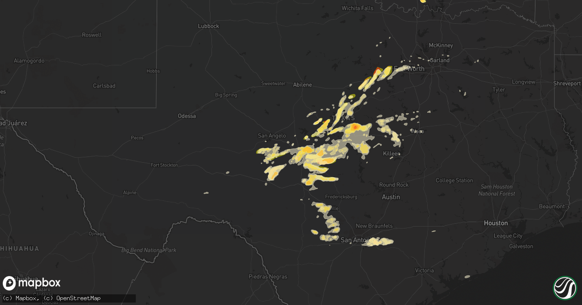
Hail Map in Texas on May 10, 2016
Get this storm
May 10 map
$229
one time, instant access
Download today. No call, no setup
Keep the $229
Bought the map and want the full workflow? Apply the entire $229 to a subscription within 7 days. None of it is wasted.
Every map, not just this one
This buys you this map. Subscription and you get every map we run, in the markets you choose from a few cities to whole states to nationwide. Plus real-time alerts the moment a storm fires.
Contact data
Name, contact info, occupancy, even credit band for addresses in the footprint. You go from where it hit to who to call.
Become the source they trust
Unlimited branding weather history reports on demand. You already have the documented answer ready for the property owner, and you are the one who showed up with it.
Property data and RoofTrace estimates
Pull up any address you have got, its value and the exact code rules for that jurisdiction, straight from One Click Code. Then RoofTrace estimates the squares, pitch, and roof value, priced the way you price.
Storm reports in Texas
Texas
| Date | Description |
|---|---|
| 05/10/20166:50 PM CDT | Ping pong ball sized hail reported in weatherford |
| 05/10/20166:45 PM CDT | A local report indicates 1.00 inch wind near WEATHERFORD |
| 05/10/20166:42 PM CDT | A local report indicates 65 MPH wind near 2 S WEATHERFORD |
| 05/10/20166:40 PM CDT | In tin top |
| 05/10/20166:40 PM CDT | Barn damaged |
| 05/10/20166:36 PM CDT | A local report indicates 60 MPH wind near 6 SW WEATHERFORD |
| 05/10/20166:15 PM CDT | A local report indicates 1.00 inch wind near 5 S SANTO |
| 05/10/20166:06 PM CDT | A local report indicates 60 MPH wind near POTTSVILLE |
| 05/10/20166:00 PM CDT | Golf ball size hail on us highway 67 on the brown and coleman county line |
| 05/10/20165:37 PM CDT | A local report indicates 1.00 inch wind near 3 NW DOOLE |
| 05/10/20165:30 PM CDT | A local report indicates 1.00 inch wind near GORMAN |
| 05/10/20165:28 PM CDT | A local report indicates 1.00 inch wind near 3 NW DOOLE |
| 05/10/20165:25 PM CDT | Quarter to ping pong ball size hail. |
| 05/10/20165:10 PM CDT | Measured at the comanche raws site - coat2 |
| 05/10/20165:04 PM CDT | Near intersection of texas state highway 16 and county road 134/262. |
| 05/10/20165:04 PM CDT | Half dollar to hen egg size hail busted windshield. |
| 05/10/20165:02 PM CDT | A local report indicates 60 MPH wind near 1 NW COMANCHE |
| 05/10/20164:54 PM CDT | 62 mph wind gust measured at comanche county airport |
| 05/10/20164:40 PM CDT | A local report indicates 1.00 inch wind near 4 S EDEN |
| 05/10/20164:40 PM CDT | Quarter size hail for 15 to 20 minutes beginning around 440 pm at fm 1689...along with 40 to 50 mph winds |
| 05/10/20164:30 PM CDT | A local report indicates 1.25 inch wind near 5 SE MAY |
| 05/10/20164:20 PM CDT | A local report indicates 1.25 inch wind near 3 NNE WINCHELL |
| 05/10/20164:10 PM CDT | Quarter size hail in winchell at 410 pm and again at 420 pm. |
| 05/10/20164:03 PM CDT | A local report indicates 1.00 inch wind near EARLY |
| 05/10/20163:50 PM CDT | On county road 258 |
| 05/10/20163:36 PM CDT | A local report indicates 1.25 inch wind near 4 E ROCKWOOD |
| 05/10/20165:45 AM CDT | Power poles broken and trailer flipped due to wind near the intersection of lakey road and fm 117. |
| 05/10/20165:18 AM CDT | Around a dozen trees were snapped and fence damage was reported in the lake valley estates subdivision. Nickel sized hail also accompanied the wind damage. |
| 05/10/20165:10 AM CDT | Golf ball sized hail reported in la vernia via facebook |
| 05/10/20165:08 AM CDT | Large trees blown down...storage building destroyed with pieces blown one quarter mile away...garage door blown in. Time of damage estimated with radar. |
| 05/10/20162:00 AM CDT | Quarter sized hail was reported by a spotter on mackay drive in kerrville. |
| 05/10/20161:18 AM CDT | Damaging thunderstorm winds uprooted a 70 foot tall pecan tree...knocked down fencing...and destroyed some outbuildings on the premiere ranch. The damage was about 3/4 |
| 05/10/20161:11 AM CDT | This storm dumped lots of hail. The hail was 8 to 10 inches deep and may have lasted from 111 am til 121 am. There was one place where the hail was about 1.5 feet deep. |
| 05/09/201610:38 PM CDT | Mostly small hail covered the ground...with a few golfball size hail stones reported. |
| 05/09/201610:31 PM CDT | A local report indicates 1.00 inch wind near CHRISTOVAL |
| 05/09/201610:29 PM CDT | A local report indicates 1.00 inch wind near CHRISTOVAL |
| 05/09/20169:20 PM CDT | Large tree down /30 inches in diameter/ blocking culberson avenue. Another large tree down on another street in town. |
| 05/09/20169:02 PM CDT | Tree blown down onto a house |
| 05/09/20169:00 PM CDT | 50 to 60 mph winds near mexia |
| 05/09/20168:12 PM CDT | A local report indicates 61 MPH wind near WEST |
| 05/09/20168:05 PM CDT | A local report indicates 75 MPH wind near 4 NW WACO |
| 05/09/20168:05 PM CDT | 60 mph wind gust on the mclennan/falls county line |
| 05/09/20168:05 PM CDT | Trees down and a small trailer blown over into a ditch |
| 05/09/20168:04 PM CDT | 6 inch tree limbs downs with an estimated 60 mph wind gust at glade road and highway 121 in euless |
| 05/09/20167:56 PM CDT | Glade road and 360. Measured with a hand-held anemometer |
| 05/09/20167:55 PM CDT | Estimated 65 mph wind gust at trinity blvd and s. Raider dr. In hurst |
| 05/09/20167:54 PM CDT | Carport and trees blown down |
| 05/09/20167:54 PM CDT | I820 north bound at randol mill road. Also multiple tree branches down |
| 05/09/20167:54 PM CDT | Trees on houses in speegleville |
| 05/09/20167:50 PM CDT | Numerous trees down in china spring |
| 05/09/20167:48 PM CDT | Kact asos |
| 05/09/20167:47 PM CDT | Also 6 inch tree limbs down. |
| 05/09/20167:37 PM CDT | Retired nws employee |
| 05/09/20167:30 PM CDT | Beach street and i-30. Also 2 feet diameter tree blown down |
| 05/09/20167:20 PM CDT | Knfw awos |
| 05/09/20167:20 PM CDT | Numerous trees down across town. |
| 05/09/20167:18 PM CDT | A local report indicates 1.75 inch wind near BRADY |
| 05/09/20167:16 PM CDT | And 3 to 4 inch tree limbs downed |
| 05/09/20167:15 PM CDT | White settlement road and chapel creek blvd |
| 05/09/20167:09 PM CDT | Quarter size hail along us highway 190 about 5 miles southwest of brady |
| 05/09/20167:05 PM CDT | 55 to 60 mph wind at fm 182 and fm 219 |
All States Impacted by Hail Map on May 10, 2016
Cities Impacted by Hail Map on May 10, 2016
- Seguin, TX
- San Antonio, TX
- Cost, TX
- Saint Hedwig, TX
- La Vernia, TX
- Nixon, TX
- Sutherland Springs, TX
- Stockdale, TX
- Adkins, TX
- Leesville, TX
- Marion, TX
- Shawneetown, IL
- Marion, IN
- La Fontaine, IN
- Pittsburg, KS
- Girard, KS
- Lometa, TX
- Goldthwaite, TX
- Lampasas, TX
- San Saba, TX
- Corbin, KY
- Science Hill, KY
- Eubank, KY
- Somerset, KY
- Valley, NE
- Fremont, NE
- Lamar, MO
- Elm Mott, TX
- Eola, TX
- D Hanis, TX
- Utopia, TX
- Gatesville, TX
- Lincoln, NE
- Waverly, NE
- Stephenville, TX
- Lipan, TX
- Santo, TX
- Millsap, TX
- Milligan, NE
- Geneva, NE
- Strang, NE
- Shickley, NE
- Friend, NE
- Ohiowa, NE
- Exeter, NE
- Marietta, OK
- Ardmore, OK
- Hampton, NE
- Rantoul, KS
- Paola, KS
- Spring Hill, KS
- Ottawa, KS
- Osawatomie, KS
- Princeton, KS
- Wellsville, KS
- Oxford, NE
- Central City, NE
- Chapman, NE
- Benedict, NE
- Hordville, NE
- Aurora, NE
- Marquette, NE
- Bradshaw, NE
- York, NE
- Polk, NE
- Bandera, TX
- Pipe Creek, TX
- Horse Cave, KY
- Hardyville, KY
- Cave City, KY
- Palacios, TX
- Matagorda, TX
- Genoa, NE
- Monroe, NE
- Platte Center, NE
- Mount Juliet, TN
- Hendersonville, TN
- Ashland City, TN
- Southside, TN
- Joelton, TN
- Greenbrier, TN
- Springfield, TN
- Whites Creek, TN
- Hermitage, TN
- Nashville, TN
- Clarksville, TN
- Pleasant View, TN
- Old Hickory, TN
- Madison, TN
- Watertown, TN
- Chapmansboro, TN
- Goodlettsville, TN
- Lebanon, TN
- Jennings, KS
- Dresden, KS
- Christoval, TX
- Eldorado, TX
- Centralia, KS
- Corning, KS
- Onaga, KS
- Vermillion, KS
- Havensville, KS
- Greenville, KY
- Mullin, TX
- Lincoln, KS
- Hazel Green, KY
- Campton, KY
- Booneville, KY
- Beattyville, KY
- Vincent, KY
- Elkhorn, NE
- Bennington, NE
- Boys Town, NE
- Carter Lake, IA
- Omaha, NE
- Waterloo, NE
- Atkinson, NE
- Stuart, NE
- Sylvan Grove, KS
- Harrodsburg, KY
- Mackville, KY
- Springfield, KY
- Parker, KS
- Centerville, KS
- Blue Mound, KS
- Pleasanton, KS
- Mound City, KS
- La Cygne, KS
- Murray, KY
- New Concord, KY
- Walker, KY
- Flat Lick, KY
- New Albany, IN
- Louisville, KY
- Ferguson, KY
- Nancy, KY
- Garner, KY
- Leburn, KY
- Clifton, TX
- Cranfills Gap, TX
- Scranton, KS
- Valparaiso, NE
- Weston, NE
- Richmond, KY
- Lancaster, KY
- Eden, TX
- Clay Center, KS
- Benton, KY
- Beloit, KS
- Mason, TX
- Drakesboro, KY
- Beech Creek, KY
- Beechmont, KY
- Parkers Lake, KY
- Whitley City, KY
- Junction, TX
- London, TX
- Comanche, TX
- London, KY
- Frankfort, KY
- Lawrenceburg, KY
- Waddy, KY
- Slaughters, KY
- Rochelle, TX
- Fredonia, TX
- Melvin, TX
- Brady, TX
- Menard, TX
- Lohn, TX
- Hext, TX
- Voca, TX
- Lane, KS
- Greeley, KS
- Carbondale, KS
- Burlingame, KS
- Osage City, KS
- Richland Springs, TX
- Ingram, TX
- Kerrville, TX
- Boston, KY
- Lebanon Junction, KY
- Eddyville, KY
- Garfield, KY
- Harned, KY
- Hardinsburg, KY
- Irvington, KY
- Jbsa Lackland, TX
- Phillipsburg, KS
- Georgetown, KY
- Stamping Ground, KY
- Jerico Springs, MO
- Elizabethtown, KY
- Edna, KS
- Altamont, KS
- Sarahsville, OH
- Caldwell, OH
- Yutan, NE
- Mead, NE
- Danville, KY
- Perryville, KY
- Nicholasville, KY
- Gallatin, TN
- Portland, TN
- Bethpage, TN
- Gravel Switch, KY
- Campbellsville, KY
- Lebanon, KY
- Bradfordsville, KY
- Bronaugh, MO
- Liberal, MO
- Rosiclare, IL
- Marion, KY
- Elizabethtown, IL
- Mapleton, KS
- Uniontown, KS
- Bronson, KS
- Redfield, KS
- Topeka, KS
- Dublin, TX
- Columbus, NE
- Priddy, TX
- Greenville, IN
- Mindenmines, MO
- Stanford, KY
- Prairie View, KS
- Olsburg, KS
- Frankfort, KS
- Blue Rapids, KS
- Randolph, KS
- Waterville, KS
- Westmoreland, KS
- Riddleton, TN
- Dixon Springs, TN
- Pleasant Shade, TN
- Guston, KY
- Ekron, KY
- Cerulean, KY
- Cadiz, KY
- Llano, TX
- Brandenburg, KY
- Stockton, MO
- Great Bend, KS
- St John, KS
- Beaver Dam, KY
- Hartford, KY
- Livermore, KY
- Madisonville, KY
- Olaton, KY
- Princeton, KY
- Rumsey, KY
- Manitou, KY
- Providence, KY
- Centertown, KY
- Nebo, KY
- Island, KY
- Hanson, KY
- Sacramento, KY
- Dundee, KY
- Hopkinsville, KY
- Gracey, KY
- Valley Mills, TX
- Salem, KY
- Saint Marys, KS
- Belvue, KS
- Paxico, KS
- Rossville, KS
- Jetson, KY
- Bee Spring, KY
- Roundhill, KY
- Caneyville, KY
- Morgantown, KY
- Brownsville, KY
- Leitchfield, KY
- Willisburg, KY
- Monticello, KY
- Masonic Home, KY
- Glenview, KY
- Pewee Valley, KY
- Crestwood, KY
- Abbott, TX
- West, TX
- Baldwin City, KS
- Brainard, NE
- Fort Worth, TX
- Gordon, TX
- Mingus, TX
- West Point, KY
- Minneapolis, KS
- Downs, KS
- Osborne, KS
- Tell City, IN
- Grantsburg, IL
- Vienna, IL
- Phillips, NE
- Reynolds Station, KY
- Fordsville, KY
- Cloverport, KY
- Grand Island, NE
- Doniphan, NE
- Alda, NE
- Lebo, KS
- Owensboro, KY
- Philpot, KY
- Robards, KY
- Rockport, IN
- Maceo, KY
- Westview, KY
- Henderson, KY
- Calhoun, KY
- Falls Of Rough, KY
- Vine Grove, KY
- Shepherdsville, KY
- Rineyville, KY
- Hudson, KY
- Utica, KY
- Custer, KY
- Eastview, KY
- Coxs Creek, KY
- Radcliff, KY
- McDaniels, KY
- Bardstown, KY
- Cecilia, KY
- Lewisport, KY
- Whitesville, KY
- Hawesville, KY
- Big Clifty, KY
- Boydton, VA
- Coleman, TX
- Munfordville, KY
- De Soto, KS
- Basehor, KS
- Leavenworth, KS
- Bonner Springs, KS
- Kansas City, KS
- Linwood, KS
- Eudora, KS
- Shawnee, KS
- Lenexa, KS
- Olathe, KS
- Gardner, KS
- Edgerton, KS
- Lansing, KS
- Trenton, KY
- Oak Grove, KY
- Pembroke, KY
- Fort Campbell, KY
- Mayetta, KS
- Agra, KS
- Clayton, KS
- Oberlin, KS
- Long Island, KS
- Almena, KS
- Kensington, KS
- Norton, KS
- Logan, KS
- Lenora, KS
- Ellsworth, KS
- Soldier, KS
- Goff, KS
- Circleville, KS
- Sevierville, TN
- Early, TX
- Blanket, TX
- Sidney, TX
- May, TX
- Hoyt, KS
- Hunt, TX
- Mountain Home, TX
- Kansas City, MO
- Herod, IL
- Harrisburg, IL
- Eddyville, IL
- Stonefort, IL
- Silver Lake, KS
- Garnett, KS
- Bucyrus, KS
- Louisburg, KS
- Barnard, KS
- Delia, KS
- Eastern, KY
- Langley, KY
- Garrett, KY
- Wayland, KY
- Hartsville, TN
- Castalian Springs, TN
- Columbia, KY
- Roanoke, TX
- Mount Vernon, KY
- Borden, IN
- Floyds Knobs, IN
- Aurora, KS
- Miltonvale, KS
- Delphos, KS
- Assaria, KS
- Lindsborg, KS
- Richmond, KS
- Sutton, NE
- Alma, NE
- Republican City, NE
- Liberty, KY
- Mannsville, KY
- Elk Horn, KY
- Russell Springs, KY
- Jamestown, KY
- Glens Fork, KY
- Breeding, KY
- Edmonton, KY
- Burnside, KY
- Bronston, KY
- Keavy, KY
- Sonora, KY
- Windsor, KY
- Canmer, KY
- Loretto, KY
- Crab Orchard, KY
- Mount Sherman, KY
- Bloomfield, KY
- Bonnieville, KY
- Dunnville, KY
- Raywick, KY
- Knob Lick, KY
- Hodgenville, KY
- Paint Lick, KY
- Clarkson, KY
- Cannelton, IN
- Knifley, KY
- Woodbine, KY
- Magnolia, KY
- Burgin, KY
- Sebree, KY
- New Haven, KY
- Bethelridge, KY
- Gradyville, KY
- Waco, KY
- Buffalo, KY
- Center, KY
- Greensburg, KY
- Summersville, KY
- Waynesburg, KY
- Junction City, KY
- Saint Francis, KY
- Berea, KY
- Glasgow, KY
- Upton, KY
- Parksville, KY
- Hustonville, KY
- Cedar Rapids, NE
- Hickory, KY
- Dallas, TX
- Ellinwood, KS
- Bushton, KS
- Claflin, KS
- Golconda, IL
- Middleburg, KY
- Hondo, TX
- Jonesboro, TX
- Santa Anna, TX
- Bangs, TX
- Gouldbusk, TX
- Rockwood, TX
- Rockwall, TX
- Royse City, TX
- Lavon, TX
- Waco, TX
- Milford, NE
- Kings Mountain, KY
- Gresham, NE
- Ceresco, NE
- Ithaca, NE
- Crescent, IA
- Dwight, NE
- Bee, NE
- Colon, NE
- Ashland, NE
- Gretna, NE
- Utica, NE
- Seward, NE
- Ulysses, NE
- Wahoo, NE
- David City, NE
- Malmo, NE
- Staplehurst, NE
- Perrin, TX
- Jacksboro, TX
- Fontana, KS
- Arlington, TX
- Bedford, TX
- Euless, TX
- Greeneville, TN
- Lyford, TX
- Simpson, IL
- Belknap, IL
- Rio Medina, TX
- Mico, TX
- Azle, TX
- Pleasant Dale, NE
- Holdrege, NE
- Ezel, KY
- Jackson, KY
- Pine Ridge, KY
- Wellington, KY
- Mize, KY
- Clay, KY
- Irvine, KY
- Hazel, KY
- Center Point, TX
- Medina, TX
- Harper, TX
- Clarksville, VA
- Skipwith, VA
- Sheldon, MO
- Dover, TN
- Stewart, TN
- Plattsmouth, NE
- Louisville, NE
- Cunningham, TN
- Hamilton, TX
- Westmoreland, TN
- Lawrence, KS
- Berryton, KS
- La Fayette, KY
- Lecompton, KS
- Tescott, KS
- Salina, KS
- Brookville, KS
- Weatherford, TX
- Lucas, KS
- Hunter, KS
- Oronogo, MO
- El Dorado Springs, MO
- Fort Scott, KS
- Deerfield, MO
- Garland, KS
- Farlington, KS
- Hepler, KS
- Mulberry, KS
- Barnes, KS
- Green, KS
- Clifton, KS
- Palmer, KS
- Leonardville, KS
- Morganville, KS
- Glasco, KS
- Longford, KS
- Concordia, KS
- Clyde, KS
- Greenleaf, KS
- Simpson, KS
- Cottontown, TN
- Cross Plains, TN
- White House, TN
- De Leon, TX
- Colorado Springs, CO
- McKee, KY
- Holton, KS
- Silver Creek, NE
- Sonora, TX
- Fairmont, NE
- Cordova, NE
- Henderson, NE
- Grafton, NE
- McCool Junction, NE
- Beaver Crossing, NE
- Waco, NE
- Adairville, KY
- Russellville, KY
- Heartwell, NE
- Honaker, VA
- White Plains, KY
- Ravenna, KY
- Funk, NE
- Axtell, NE
- Frontenac, KS
- Dunmor, KY
- Crofton, KY
- Rochester, KY
- Belton, KY
- Browder, KY
- South Hill, VA
- Bracey, VA
- Fairview, KS
- Morrill, KS
- Rogers, KY
- Zoe, KY
- Slade, KY
- Tyner, KY
- Prague, NE
- Chaplin, KY
- Stromsburg, NE
- Arlington, KY
- Fancy Farm, KY
- McDowell, KY
- Printer, KY
- Harold, KY
- Grethel, KY
- Minnie, KY
- Drift, KY
- Corydon, IN
- Bellevue, NE
- Council Bluffs, IA
- Cedar Creek, NE
- Springfield, NE
- Papillion, NE
- Pacific Junction, IA
- Lafayette, TN
- Weimar, TX
- Cedar Hill, TN
- Livingston, KY
- Madill, OK
- Melvern, KS
- Williamsburg, KS
- Fredonia, KY
- Zephyr, TX
- Mammoth Cave, KY
- Cub Run, KY
- Aquilla, TX
- Emmett, KS
- Mousie, KY
- Meriden, KS
- Sandgap, KY
- Herndon, KY
- Muldraugh, KY
- Webster, KY
- Guthrie, KY
- Adams, TN
- Mertzon, TX
- Rising Star, TX
- Vancourt, TX
- Carbon, TX
- Evant, TX
- Brownwood, TX
- Star, TX
- Pottsville, TX
- Brookesmith, TX
- San Angelo, TX
- Minden, NE
- Atlanta, NE
- Bertrand, NE
- Orleans, NE
- Mayfield, KY
- Simpsonville, KY
- Stanton, KY
- Kenesaw, NE
- Wakarusa, KS
- Oglesby, TX
- Scottsburg, VA
- Baskerville, VA
- Red Oak, VA
- Halifax, VA
- Elkton, KY
- Aledo, TX
- Pine Knot, KY
- Ozawkie, KS
- Lorraine, KS
- Holyrood, KS
- Talpa, TX
- Gorman, TX
- Millersview, TX
- Newport, NE
- Milton, TN
- Auburntown, TN
- Whitney, TX
- Dryden, TX
- Kanopolis, KS
- Park City, KY
- Waverly, KS
- Hico, TX
- Pikeville, KY
- Virgie, KY
- Elkhorn City, KY
- Weeksbury, KY
- Saronville, NE
- Ellis, KS
- Geneseo, KS
- Antioch, TN
- Emory, TX
- Derby, IN
- Mounds, IL
- Poolville, TX
- Tolar, TX
- Bluff Dale, TX
- Cherokee, TX
- Oskaloosa, KS
- Grantville, KS
- Tecumseh, KS
- Denison, KS
- Valley Falls, KS
- Auburn, KS
- Mills, NE
- Coppell, TX
- Irving, TX
- Sharon Grove, KY
- Lewisburg, KY
- Asbury, MO
- South Boston, VA
- Clover, VA
- La Crosse, VA
- Chase City, VA
- Vest, KY
- Hindman, KY
- Bulan, KY
- Palmyra, TN
- Charlotte, TN
- Cumberland Furnace, TN
- Evansville, IN
- Versailles, KY
- Rhodelia, KY
- Union Star, KY
- Edson, KS
- Scottsville, KY
- Salvisa, KY
- Ramsey, IN
- Beverly, KS
- Wilson, KS
- Dawson Springs, KY
- San Perlita, TX
- Humansville, MO
- Collins, MO
- Peyton, CO
- Ordway, CO
- Rush, CO
- Cave In Rock, IL
- Sturgis, KY
- Symsonia, KY
- West Liberty, KY
- Reading, KS
- Hastings, NE
- Trumbull, NE
- Saint Edward, NE
- Wylie, TX
- Desdemona, TX
- Raccoon, KY
- Campbell, NE
- Martin, TN
- Lost Creek, KY
- Whick, KY
- Giltner, NE
- Saint Libory, NE
- Juniata, NE
- Georgetown, IN
- Lanesville, IN
- Tonganoxie, KS
- Allen, KY
- Martin, KY
- Bedford, VA
- Brewster, KS
- Paris, TN
- Morse Bluff, NE
- Hueysville, KY
- Lackey, KY
- Clayhole, KY
- Pawnee Rock, KS
- Mauckport, IN
- Central, IN
- Ozona, TX
- Bunker Hill, KS
- Russell, KS
- Waldo, KS
- Easton, KS
- Benedict, KS
- Payneville, KY
- Stephensport, KY
- Tiline, KY
- Kuttawa, KY
- Calhan, CO
- Gamaliel, KY
- Fountain Run, KY
- Lockwood, MO
- Greenfield, MO
- Lindsay, NE
- Cherokee, KS
- Arma, KS
- Franklin, KS
- Harveyville, KS
- Lynchburg, VA
- Cumberland City, TN
- Big Rock, TN
- Bumpus Mills, TN
- Morland, KS
- Sellersburg, IN
- Charlestown, IN
- Jeffersonville, IN
- Clarksville, IN
- Burkett, TX
- White Mills, KY
- Rocksprings, TX
- Buffalo Junction, VA
- Purmela, TX
- Killeen, TX
- Ozark, IL
- Salyersville, KY
- Red Boiling Springs, TN
- Southlake, TX
- Grapevine, TX
- Rowdy, KY
- Banner, KY
- Clay City, KY
- Saxe, VA
- Steele, KY
- Fedscreek, KY
- McGregor, TX
- Ranger, TX
- La Vista, NE
- Wakefield, KS
- Junction City, KS
- Chapman, KS
- Topmost, KY
- Pippa Passes, KY
- Raven, KY
- Dema, KY
- Colby, KS
- Manhattan, KS
- Bevinsville, KY
- Riley, KS
- Mabank, TX
- Eustace, TX
- Yosemite, KY
- Copperas Cove, TX
- McLouth, KS
- Battletown, KY
- Orlando, KY
- Cross Plains, TX
- Ewing, VA
- Harrogate, TN
- Doole, TX
- Wilmore, KY
- Depauw, IN
- Grand Rivers, KY
- Millwood, KY
- Bruno, NE
- Levant, KS
- Tishomingo, OK
- Mill Creek, OK
- Naval Air Station Jrb, TX
- Rome, IN
- Carthage, MO
- Jasper, MO
- Arcadia, KS
- Belton, TX
- Pekin, IN
- Palmyra, IN
- Newman Grove, NE
- Horse Branch, KY
- Selden, KS
- Dunnegan, MO
- Perry, KS
- Emporia, KS
- Collyer, KS
- Shelby, NE
- Neosho Rapids, KS
- Walland, TN
- Osceola, NE
- Keller, TX
- Maryville, TN
- Williamsburg, KY
- Liberty, TN
- Madison Heights, VA
- Milltown, IN
- Dixon, KY
- Mannsville, OK
- Archer, NE
- Dorrance, KS
- Honey Creek, IA
- Gunlock, KY
- Hazard, KY
- Ary, KY
- Kite, KY
- Wheelwright, KY
- Emmalena, KY
- Indian Mound, TN
- Carthage, TN
- Orlinda, TN
- Woodbury, TN
- Bardwell, KY
- Erin, TN
- Clinton, KY
- Olmstead, KY
- Allensville, KY
- Lascassas, TN
- Gilbertsville, KY
- Whitleyville, TN
- Woodway, TX
- Fort Hood, TX
- Moody, TX
- Meridian, TX
- Alvord, TX
- Chico, TX
- Malone, TX
- Paint Rock, TX
- Smiths Grove, KY
- Amelia, NE
- Albany, KY
- Alpha, KY
- Plainville, KS
- Granbury, TX
- Cresson, TX
- Eskridge, KS
- Big Island, VA
- Forest, VA
- Goode, VA
- Parrottsville, TN
- Lyndon, KS
- Burke, SD
- Nortonville, KY
- Laconia, IN
- Elizabeth, IN
- Denton, KY
- Webbville, KY
- Grayson, KY
- Louisa, KY
- Norcatur, KS
- Clarks, NE
- Lewisville, OH
- Summerfield, OH
- Mineral Wells, TX
- Fort McKavett, TX


