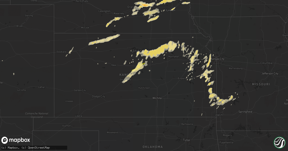
Hail Map in Kansas on May 10, 2016
Get this storm
May 10 map
$229
one time, instant access
Download today. No call, no setup
Keep the $229
Bought the map and want the full workflow? Apply the entire $229 to a subscription within 7 days. None of it is wasted.
Every map, not just this one
This buys you this map. Subscription and you get every map we run, in the markets you choose from a few cities to whole states to nationwide. Plus real-time alerts the moment a storm fires.
Contact data
Name, contact info, occupancy, even credit band for addresses in the footprint. You go from where it hit to who to call.
Become the source they trust
Unlimited branding weather history reports on demand. You already have the documented answer ready for the property owner, and you are the one who showed up with it.
Property data and RoofTrace estimates
Pull up any address you have got, its value and the exact code rules for that jurisdiction, straight from One Click Code. Then RoofTrace estimates the squares, pitch, and roof value, priced the way you price.
Storm reports in Kansas
Kansas
| Date | Description |
|---|---|
| 05/10/20166:35 PM CDT | A local report indicates 1.00 inch wind near PRAIRIE VIEW |
| 05/10/20166:20 PM CDT | Estimated gusts of 50-60 mph. No damage reported. |
| 05/10/20166:00 PM CDT | Est 65-70 mph wind gusts. |
| 05/10/20165:30 PM CDT | A local report indicates 1.00 inch wind near JENNINGS |
| 05/10/20165:05 PM CDT | A local report indicates 1.75 inch wind near 3 S HEALY |
| 05/10/20166:57 AM CDT | Numerous tree limbs and powerlines down throughout city |
| 05/10/20166:00 AM CDT | Tree down across roadway. Power outage across southern leavenworth |
| 05/10/20165:30 AM CDT | Roof and window damage to city buildings. |
| 05/10/20165:21 AM CDT | Received through social media |
| 05/10/20165:12 AM CDT | Received through social media |
| 05/10/20164:55 AM CDT | 60 mph wind gusts reported near highway 36 at the marshall/washington country line |
| 05/10/20164:46 AM CDT | A local report indicates 63 MPH wind near FORT RILEY AIRFIELD |
| 05/10/20164:40 AM CDT | A local report indicates 63 MPH wind near FORT RILEY AIRFIELD |
| 05/10/20163:30 AM CDT | Fence blown down along with tree limbs down from t-storm winds. |
| 05/10/20163:08 AM CDT | With estimated 70 mph winds |
| 05/10/20163:08 AM CDT | Also reported quarter size hail. Delayed report. |
| 05/10/20163:00 AM CDT | Delayed report |
All States Impacted by Hail Map on May 10, 2016
Cities Impacted by Hail Map on May 10, 2016
- Seguin, TX
- San Antonio, TX
- Cost, TX
- Saint Hedwig, TX
- La Vernia, TX
- Nixon, TX
- Sutherland Springs, TX
- Stockdale, TX
- Adkins, TX
- Leesville, TX
- Marion, TX
- Shawneetown, IL
- Marion, IN
- La Fontaine, IN
- Pittsburg, KS
- Girard, KS
- Lometa, TX
- Goldthwaite, TX
- Lampasas, TX
- San Saba, TX
- Corbin, KY
- Science Hill, KY
- Eubank, KY
- Somerset, KY
- Valley, NE
- Fremont, NE
- Lamar, MO
- Elm Mott, TX
- Eola, TX
- D Hanis, TX
- Utopia, TX
- Gatesville, TX
- Lincoln, NE
- Waverly, NE
- Stephenville, TX
- Lipan, TX
- Santo, TX
- Millsap, TX
- Milligan, NE
- Geneva, NE
- Strang, NE
- Shickley, NE
- Friend, NE
- Ohiowa, NE
- Exeter, NE
- Marietta, OK
- Ardmore, OK
- Hampton, NE
- Rantoul, KS
- Paola, KS
- Spring Hill, KS
- Ottawa, KS
- Osawatomie, KS
- Princeton, KS
- Wellsville, KS
- Oxford, NE
- Central City, NE
- Chapman, NE
- Benedict, NE
- Hordville, NE
- Aurora, NE
- Marquette, NE
- Bradshaw, NE
- York, NE
- Polk, NE
- Bandera, TX
- Pipe Creek, TX
- Horse Cave, KY
- Hardyville, KY
- Cave City, KY
- Palacios, TX
- Matagorda, TX
- Genoa, NE
- Monroe, NE
- Platte Center, NE
- Mount Juliet, TN
- Hendersonville, TN
- Ashland City, TN
- Southside, TN
- Joelton, TN
- Greenbrier, TN
- Springfield, TN
- Whites Creek, TN
- Hermitage, TN
- Nashville, TN
- Clarksville, TN
- Pleasant View, TN
- Old Hickory, TN
- Madison, TN
- Watertown, TN
- Chapmansboro, TN
- Goodlettsville, TN
- Lebanon, TN
- Jennings, KS
- Dresden, KS
- Christoval, TX
- Eldorado, TX
- Centralia, KS
- Corning, KS
- Onaga, KS
- Vermillion, KS
- Havensville, KS
- Greenville, KY
- Mullin, TX
- Lincoln, KS
- Hazel Green, KY
- Campton, KY
- Booneville, KY
- Beattyville, KY
- Vincent, KY
- Elkhorn, NE
- Bennington, NE
- Boys Town, NE
- Carter Lake, IA
- Omaha, NE
- Waterloo, NE
- Atkinson, NE
- Stuart, NE
- Sylvan Grove, KS
- Harrodsburg, KY
- Mackville, KY
- Springfield, KY
- Parker, KS
- Centerville, KS
- Blue Mound, KS
- Pleasanton, KS
- Mound City, KS
- La Cygne, KS
- Murray, KY
- New Concord, KY
- Walker, KY
- Flat Lick, KY
- New Albany, IN
- Louisville, KY
- Ferguson, KY
- Nancy, KY
- Garner, KY
- Leburn, KY
- Clifton, TX
- Cranfills Gap, TX
- Scranton, KS
- Valparaiso, NE
- Weston, NE
- Richmond, KY
- Lancaster, KY
- Eden, TX
- Clay Center, KS
- Benton, KY
- Beloit, KS
- Mason, TX
- Drakesboro, KY
- Beech Creek, KY
- Beechmont, KY
- Parkers Lake, KY
- Whitley City, KY
- Junction, TX
- London, TX
- Comanche, TX
- London, KY
- Frankfort, KY
- Lawrenceburg, KY
- Waddy, KY
- Slaughters, KY
- Rochelle, TX
- Fredonia, TX
- Melvin, TX
- Brady, TX
- Menard, TX
- Lohn, TX
- Hext, TX
- Voca, TX
- Lane, KS
- Greeley, KS
- Carbondale, KS
- Burlingame, KS
- Osage City, KS
- Richland Springs, TX
- Ingram, TX
- Kerrville, TX
- Boston, KY
- Lebanon Junction, KY
- Eddyville, KY
- Garfield, KY
- Harned, KY
- Hardinsburg, KY
- Irvington, KY
- Jbsa Lackland, TX
- Phillipsburg, KS
- Georgetown, KY
- Stamping Ground, KY
- Jerico Springs, MO
- Elizabethtown, KY
- Edna, KS
- Altamont, KS
- Sarahsville, OH
- Caldwell, OH
- Yutan, NE
- Mead, NE
- Danville, KY
- Perryville, KY
- Nicholasville, KY
- Gallatin, TN
- Portland, TN
- Bethpage, TN
- Gravel Switch, KY
- Campbellsville, KY
- Lebanon, KY
- Bradfordsville, KY
- Bronaugh, MO
- Liberal, MO
- Rosiclare, IL
- Marion, KY
- Elizabethtown, IL
- Mapleton, KS
- Uniontown, KS
- Bronson, KS
- Redfield, KS
- Topeka, KS
- Dublin, TX
- Columbus, NE
- Priddy, TX
- Greenville, IN
- Mindenmines, MO
- Stanford, KY
- Prairie View, KS
- Olsburg, KS
- Frankfort, KS
- Blue Rapids, KS
- Randolph, KS
- Waterville, KS
- Westmoreland, KS
- Riddleton, TN
- Dixon Springs, TN
- Pleasant Shade, TN
- Guston, KY
- Ekron, KY
- Cerulean, KY
- Cadiz, KY
- Llano, TX
- Brandenburg, KY
- Stockton, MO
- Great Bend, KS
- St John, KS
- Beaver Dam, KY
- Hartford, KY
- Livermore, KY
- Madisonville, KY
- Olaton, KY
- Princeton, KY
- Rumsey, KY
- Manitou, KY
- Providence, KY
- Centertown, KY
- Nebo, KY
- Island, KY
- Hanson, KY
- Sacramento, KY
- Dundee, KY
- Hopkinsville, KY
- Gracey, KY
- Valley Mills, TX
- Salem, KY
- Saint Marys, KS
- Belvue, KS
- Paxico, KS
- Rossville, KS
- Jetson, KY
- Bee Spring, KY
- Roundhill, KY
- Caneyville, KY
- Morgantown, KY
- Brownsville, KY
- Leitchfield, KY
- Willisburg, KY
- Monticello, KY
- Masonic Home, KY
- Glenview, KY
- Pewee Valley, KY
- Crestwood, KY
- Abbott, TX
- West, TX
- Baldwin City, KS
- Brainard, NE
- Fort Worth, TX
- Gordon, TX
- Mingus, TX
- West Point, KY
- Minneapolis, KS
- Downs, KS
- Osborne, KS
- Tell City, IN
- Grantsburg, IL
- Vienna, IL
- Phillips, NE
- Reynolds Station, KY
- Fordsville, KY
- Cloverport, KY
- Grand Island, NE
- Doniphan, NE
- Alda, NE
- Lebo, KS
- Owensboro, KY
- Philpot, KY
- Robards, KY
- Rockport, IN
- Maceo, KY
- Westview, KY
- Henderson, KY
- Calhoun, KY
- Falls Of Rough, KY
- Vine Grove, KY
- Shepherdsville, KY
- Rineyville, KY
- Hudson, KY
- Utica, KY
- Custer, KY
- Eastview, KY
- Coxs Creek, KY
- Radcliff, KY
- McDaniels, KY
- Bardstown, KY
- Cecilia, KY
- Lewisport, KY
- Whitesville, KY
- Hawesville, KY
- Big Clifty, KY
- Boydton, VA
- Coleman, TX
- Munfordville, KY
- De Soto, KS
- Basehor, KS
- Leavenworth, KS
- Bonner Springs, KS
- Kansas City, KS
- Linwood, KS
- Eudora, KS
- Shawnee, KS
- Lenexa, KS
- Olathe, KS
- Gardner, KS
- Edgerton, KS
- Lansing, KS
- Trenton, KY
- Oak Grove, KY
- Pembroke, KY
- Fort Campbell, KY
- Mayetta, KS
- Agra, KS
- Clayton, KS
- Oberlin, KS
- Long Island, KS
- Almena, KS
- Kensington, KS
- Norton, KS
- Logan, KS
- Lenora, KS
- Ellsworth, KS
- Soldier, KS
- Goff, KS
- Circleville, KS
- Sevierville, TN
- Early, TX
- Blanket, TX
- Sidney, TX
- May, TX
- Hoyt, KS
- Hunt, TX
- Mountain Home, TX
- Kansas City, MO
- Herod, IL
- Harrisburg, IL
- Eddyville, IL
- Stonefort, IL
- Silver Lake, KS
- Garnett, KS
- Bucyrus, KS
- Louisburg, KS
- Barnard, KS
- Delia, KS
- Eastern, KY
- Langley, KY
- Garrett, KY
- Wayland, KY
- Hartsville, TN
- Castalian Springs, TN
- Columbia, KY
- Roanoke, TX
- Mount Vernon, KY
- Borden, IN
- Floyds Knobs, IN
- Aurora, KS
- Miltonvale, KS
- Delphos, KS
- Assaria, KS
- Lindsborg, KS
- Richmond, KS
- Sutton, NE
- Alma, NE
- Republican City, NE
- Liberty, KY
- Mannsville, KY
- Elk Horn, KY
- Russell Springs, KY
- Jamestown, KY
- Glens Fork, KY
- Breeding, KY
- Edmonton, KY
- Burnside, KY
- Bronston, KY
- Keavy, KY
- Sonora, KY
- Windsor, KY
- Canmer, KY
- Loretto, KY
- Crab Orchard, KY
- Mount Sherman, KY
- Bloomfield, KY
- Bonnieville, KY
- Dunnville, KY
- Raywick, KY
- Knob Lick, KY
- Hodgenville, KY
- Paint Lick, KY
- Clarkson, KY
- Cannelton, IN
- Knifley, KY
- Woodbine, KY
- Magnolia, KY
- Burgin, KY
- Sebree, KY
- New Haven, KY
- Bethelridge, KY
- Gradyville, KY
- Waco, KY
- Buffalo, KY
- Center, KY
- Greensburg, KY
- Summersville, KY
- Waynesburg, KY
- Junction City, KY
- Saint Francis, KY
- Berea, KY
- Glasgow, KY
- Upton, KY
- Parksville, KY
- Hustonville, KY
- Cedar Rapids, NE
- Hickory, KY
- Dallas, TX
- Ellinwood, KS
- Bushton, KS
- Claflin, KS
- Golconda, IL
- Middleburg, KY
- Hondo, TX
- Jonesboro, TX
- Santa Anna, TX
- Bangs, TX
- Gouldbusk, TX
- Rockwood, TX
- Rockwall, TX
- Royse City, TX
- Lavon, TX
- Waco, TX
- Milford, NE
- Kings Mountain, KY
- Gresham, NE
- Ceresco, NE
- Ithaca, NE
- Crescent, IA
- Dwight, NE
- Bee, NE
- Colon, NE
- Ashland, NE
- Gretna, NE
- Utica, NE
- Seward, NE
- Ulysses, NE
- Wahoo, NE
- David City, NE
- Malmo, NE
- Staplehurst, NE
- Perrin, TX
- Jacksboro, TX
- Fontana, KS
- Arlington, TX
- Bedford, TX
- Euless, TX
- Greeneville, TN
- Lyford, TX
- Simpson, IL
- Belknap, IL
- Rio Medina, TX
- Mico, TX
- Azle, TX
- Pleasant Dale, NE
- Holdrege, NE
- Ezel, KY
- Jackson, KY
- Pine Ridge, KY
- Wellington, KY
- Mize, KY
- Clay, KY
- Irvine, KY
- Hazel, KY
- Center Point, TX
- Medina, TX
- Harper, TX
- Clarksville, VA
- Skipwith, VA
- Sheldon, MO
- Dover, TN
- Stewart, TN
- Plattsmouth, NE
- Louisville, NE
- Cunningham, TN
- Hamilton, TX
- Westmoreland, TN
- Lawrence, KS
- Berryton, KS
- La Fayette, KY
- Lecompton, KS
- Tescott, KS
- Salina, KS
- Brookville, KS
- Weatherford, TX
- Lucas, KS
- Hunter, KS
- Oronogo, MO
- El Dorado Springs, MO
- Fort Scott, KS
- Deerfield, MO
- Garland, KS
- Farlington, KS
- Hepler, KS
- Mulberry, KS
- Barnes, KS
- Green, KS
- Clifton, KS
- Palmer, KS
- Leonardville, KS
- Morganville, KS
- Glasco, KS
- Longford, KS
- Concordia, KS
- Clyde, KS
- Greenleaf, KS
- Simpson, KS
- Cottontown, TN
- Cross Plains, TN
- White House, TN
- De Leon, TX
- Colorado Springs, CO
- McKee, KY
- Holton, KS
- Silver Creek, NE
- Sonora, TX
- Fairmont, NE
- Cordova, NE
- Henderson, NE
- Grafton, NE
- McCool Junction, NE
- Beaver Crossing, NE
- Waco, NE
- Adairville, KY
- Russellville, KY
- Heartwell, NE
- Honaker, VA
- White Plains, KY
- Ravenna, KY
- Funk, NE
- Axtell, NE
- Frontenac, KS
- Dunmor, KY
- Crofton, KY
- Rochester, KY
- Belton, KY
- Browder, KY
- South Hill, VA
- Bracey, VA
- Fairview, KS
- Morrill, KS
- Rogers, KY
- Zoe, KY
- Slade, KY
- Tyner, KY
- Prague, NE
- Chaplin, KY
- Stromsburg, NE
- Arlington, KY
- Fancy Farm, KY
- McDowell, KY
- Printer, KY
- Harold, KY
- Grethel, KY
- Minnie, KY
- Drift, KY
- Corydon, IN
- Bellevue, NE
- Council Bluffs, IA
- Cedar Creek, NE
- Springfield, NE
- Papillion, NE
- Pacific Junction, IA
- Lafayette, TN
- Weimar, TX
- Cedar Hill, TN
- Livingston, KY
- Madill, OK
- Melvern, KS
- Williamsburg, KS
- Fredonia, KY
- Zephyr, TX
- Mammoth Cave, KY
- Cub Run, KY
- Aquilla, TX
- Emmett, KS
- Mousie, KY
- Meriden, KS
- Sandgap, KY
- Herndon, KY
- Muldraugh, KY
- Webster, KY
- Guthrie, KY
- Adams, TN
- Mertzon, TX
- Rising Star, TX
- Vancourt, TX
- Carbon, TX
- Evant, TX
- Brownwood, TX
- Star, TX
- Pottsville, TX
- Brookesmith, TX
- San Angelo, TX
- Minden, NE
- Atlanta, NE
- Bertrand, NE
- Orleans, NE
- Mayfield, KY
- Simpsonville, KY
- Stanton, KY
- Kenesaw, NE
- Wakarusa, KS
- Oglesby, TX
- Scottsburg, VA
- Baskerville, VA
- Red Oak, VA
- Halifax, VA
- Elkton, KY
- Aledo, TX
- Pine Knot, KY
- Ozawkie, KS
- Lorraine, KS
- Holyrood, KS
- Talpa, TX
- Gorman, TX
- Millersview, TX
- Newport, NE
- Milton, TN
- Auburntown, TN
- Whitney, TX
- Dryden, TX
- Kanopolis, KS
- Park City, KY
- Waverly, KS
- Hico, TX
- Pikeville, KY
- Virgie, KY
- Elkhorn City, KY
- Weeksbury, KY
- Saronville, NE
- Ellis, KS
- Geneseo, KS
- Antioch, TN
- Emory, TX
- Derby, IN
- Mounds, IL
- Poolville, TX
- Tolar, TX
- Bluff Dale, TX
- Cherokee, TX
- Oskaloosa, KS
- Grantville, KS
- Tecumseh, KS
- Denison, KS
- Valley Falls, KS
- Auburn, KS
- Mills, NE
- Coppell, TX
- Irving, TX
- Sharon Grove, KY
- Lewisburg, KY
- Asbury, MO
- South Boston, VA
- Clover, VA
- La Crosse, VA
- Chase City, VA
- Vest, KY
- Hindman, KY
- Bulan, KY
- Palmyra, TN
- Charlotte, TN
- Cumberland Furnace, TN
- Evansville, IN
- Versailles, KY
- Rhodelia, KY
- Union Star, KY
- Edson, KS
- Scottsville, KY
- Salvisa, KY
- Ramsey, IN
- Beverly, KS
- Wilson, KS
- Dawson Springs, KY
- San Perlita, TX
- Humansville, MO
- Collins, MO
- Peyton, CO
- Ordway, CO
- Rush, CO
- Cave In Rock, IL
- Sturgis, KY
- Symsonia, KY
- West Liberty, KY
- Reading, KS
- Hastings, NE
- Trumbull, NE
- Saint Edward, NE
- Wylie, TX
- Desdemona, TX
- Raccoon, KY
- Campbell, NE
- Martin, TN
- Lost Creek, KY
- Whick, KY
- Giltner, NE
- Saint Libory, NE
- Juniata, NE
- Georgetown, IN
- Lanesville, IN
- Tonganoxie, KS
- Allen, KY
- Martin, KY
- Bedford, VA
- Brewster, KS
- Paris, TN
- Morse Bluff, NE
- Hueysville, KY
- Lackey, KY
- Clayhole, KY
- Pawnee Rock, KS
- Mauckport, IN
- Central, IN
- Ozona, TX
- Bunker Hill, KS
- Russell, KS
- Waldo, KS
- Easton, KS
- Benedict, KS
- Payneville, KY
- Stephensport, KY
- Tiline, KY
- Kuttawa, KY
- Calhan, CO
- Gamaliel, KY
- Fountain Run, KY
- Lockwood, MO
- Greenfield, MO
- Lindsay, NE
- Cherokee, KS
- Arma, KS
- Franklin, KS
- Harveyville, KS
- Lynchburg, VA
- Cumberland City, TN
- Big Rock, TN
- Bumpus Mills, TN
- Morland, KS
- Sellersburg, IN
- Charlestown, IN
- Jeffersonville, IN
- Clarksville, IN
- Burkett, TX
- White Mills, KY
- Rocksprings, TX
- Buffalo Junction, VA
- Purmela, TX
- Killeen, TX
- Ozark, IL
- Salyersville, KY
- Red Boiling Springs, TN
- Southlake, TX
- Grapevine, TX
- Rowdy, KY
- Banner, KY
- Clay City, KY
- Saxe, VA
- Steele, KY
- Fedscreek, KY
- McGregor, TX
- Ranger, TX
- La Vista, NE
- Wakefield, KS
- Junction City, KS
- Chapman, KS
- Topmost, KY
- Pippa Passes, KY
- Raven, KY
- Dema, KY
- Colby, KS
- Manhattan, KS
- Bevinsville, KY
- Riley, KS
- Mabank, TX
- Eustace, TX
- Yosemite, KY
- Copperas Cove, TX
- McLouth, KS
- Battletown, KY
- Orlando, KY
- Cross Plains, TX
- Ewing, VA
- Harrogate, TN
- Doole, TX
- Wilmore, KY
- Depauw, IN
- Grand Rivers, KY
- Millwood, KY
- Bruno, NE
- Levant, KS
- Tishomingo, OK
- Mill Creek, OK
- Naval Air Station Jrb, TX
- Rome, IN
- Carthage, MO
- Jasper, MO
- Arcadia, KS
- Belton, TX
- Pekin, IN
- Palmyra, IN
- Newman Grove, NE
- Horse Branch, KY
- Selden, KS
- Dunnegan, MO
- Perry, KS
- Emporia, KS
- Collyer, KS
- Shelby, NE
- Neosho Rapids, KS
- Walland, TN
- Osceola, NE
- Keller, TX
- Maryville, TN
- Williamsburg, KY
- Liberty, TN
- Madison Heights, VA
- Milltown, IN
- Dixon, KY
- Mannsville, OK
- Archer, NE
- Dorrance, KS
- Honey Creek, IA
- Gunlock, KY
- Hazard, KY
- Ary, KY
- Kite, KY
- Wheelwright, KY
- Emmalena, KY
- Indian Mound, TN
- Carthage, TN
- Orlinda, TN
- Woodbury, TN
- Bardwell, KY
- Erin, TN
- Clinton, KY
- Olmstead, KY
- Allensville, KY
- Lascassas, TN
- Gilbertsville, KY
- Whitleyville, TN
- Woodway, TX
- Fort Hood, TX
- Moody, TX
- Meridian, TX
- Alvord, TX
- Chico, TX
- Malone, TX
- Paint Rock, TX
- Smiths Grove, KY
- Amelia, NE
- Albany, KY
- Alpha, KY
- Plainville, KS
- Granbury, TX
- Cresson, TX
- Eskridge, KS
- Big Island, VA
- Forest, VA
- Goode, VA
- Parrottsville, TN
- Lyndon, KS
- Burke, SD
- Nortonville, KY
- Laconia, IN
- Elizabeth, IN
- Denton, KY
- Webbville, KY
- Grayson, KY
- Louisa, KY
- Norcatur, KS
- Clarks, NE
- Lewisville, OH
- Summerfield, OH
- Mineral Wells, TX
- Fort McKavett, TX


