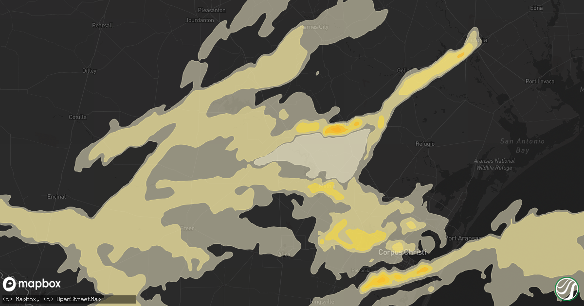
Hail Map in Corpus Christi, TX on May 10, 2012
Get this storm
May 10 map
$229
one time, instant access
Download today. No call, no setup
Keep the $229
Bought the map and want the full workflow? Apply the entire $229 to a subscription within 7 days. None of it is wasted.
Every map, not just this one
This buys you this map. Subscription and you get every map we run, in the markets you choose from a few cities to whole states to nationwide. Plus real-time alerts the moment a storm fires.
Contact data
Name, contact info, occupancy, even credit band for addresses in the footprint. You go from where it hit to who to call.
Become the source they trust
Unlimited branding weather history reports on demand. You already have the documented answer ready for the property owner, and you are the one who showed up with it.
Property data and RoofTrace estimates
Pull up any address you have got, its value and the exact code rules for that jurisdiction, straight from One Click Code. Then RoofTrace estimates the squares, pitch, and roof value, priced the way you price.
Storm reports in Corpus Christi, TX
Corpus Christi, TX
| Date | Description |
|---|---|
| 05/10/20123:24 PM CDT | Larger hail now at mustang island state park. |
| 05/10/20123:12 PM CDT | At mustang island state park |
| 05/10/20122:57 PM CDT | Hail at the corpus christi naval air station |
| 05/10/20122:53 PM CDT | A local report indicates 60 MPH wind near CC NAS |
| 05/10/20122:16 PM CDT | A local report indicates 1.75 inch wind near 2 N CHAPMAN RANCH |
| 05/10/20122:06 PM CDT | A local report indicates 1.00 inch wind near CHAPMAN RANCH |
| 05/09/201210:40 PM CDT | Reported from residence near yorktown and saratoga streets. |
| 05/09/201210:27 PM CDT | Quarter size hail falling at nws office. |
| 05/09/201210:20 PM CDT | Tornado touched down in open field 2 miles se of corpus christi international airport. Traveled southeast snapping utility poles in front of clear channel radio station |
| 05/09/201210:18 PM CDT | Heavy damage to the roof of a storage place |
| 05/09/201210:15 PM CDT | Easily 70 mph and splitting trees in the calallen area |
| 05/09/201210:10 PM CDT | Car wash was destroyed near calallen high school...farm road 624 and wood river drive. |
All States Impacted by Hail Map on May 10, 2012
All Cities Impacted by Hail Map on May 10, 2012
- Kingsville, TX
- Belle Glade, FL
- Laredo, TX
- Dilley, TX
- George West, TX
- Cotulla, TX
- Tilden, TX
- Victoria, TX
- Goliad, TX
- San Ygnacio, TX
- Zapata, TX
- Beeville, TX
- Boerne, TX
- Quemado, TX
- Yoakum, TX
- Shiner, TX
- Del Rio, TX
- Rocksprings, TX
- Poth, TX
- Pleasanton, TX
- Falls City, TX
- Smiley, TX
- Floresville, TX
- Gillett, TX
- Stockdale, TX
- Whitsett, TX
- Jourdanton, TX
- Calliham, TX
- Three Rivers, TX
- Jupiter, FL
- West Palm Beach, FL
- Hobe Sound, FL
- Loxahatchee, FL
- Encinal, TX
- Dryden, TX
- Fort Stockton, TX
- Blanco, TX
- Johnson City, TX
- Kendalia, TX
- Comfort, TX
- San Diego, TX
- Freer, TX
- Orange Grove, TX
- Concepcion, TX
- Runge, TX
- Nordheim, TX
- Yorktown, TX
- Cuero, TX
- San Angelo, TX
- Los Fresnos, TX
- San Benito, TX
- Rio Hondo, TX
- Crystal City, TX
- Big Wells, TX
- Carrizo Springs, TX
- Catarina, TX
- Asherton, TX
- Batesville, TX
- La Pryor, TX
- Pearsall, TX
- Mathis, TX
- Sandia, TX
- Taft, TX
- San Antonio, TX
- Von Ormy, TX
- Guerra, TX
- Hebbronville, TX
- Pflugerville, TX
- Cedar Park, TX
- Round Rock, TX
- Leander, TX
- Austin, TX
- Eagle Pass, TX
- Fayetteville, TX
- Weimar, TX
- Ellinger, TX
- Port Aransas, TX
- Robstown, TX
- Bishop, TX
- Corpus Christi, TX
- Riviera, TX
- Sinton, TX
- Comstock, TX
- Alice, TX
- Junction, TX
- Roosevelt, TX
- Sonora, TX
- Christine, TX
- Karnes City, TX
- Woodsboro, TX
- Brownsville, TX
- Rio Grande City, TX
- Santa Elena, TX
- Marathon, TX
- Hidalgo, TX
- Mcallen, TX
- Pharr, TX
- San Juan, TX
- Alamo, TX
- Portland, TX
- Skidmore, TX
- Realitos, TX
- Odem, TX
- Kenedy, TX
- Gregory, TX
- Mirando City, TX
- Campbellton, TX
- Hobson, TX
- Bruni, TX
- Oilton, TX
- Uvalde, TX
- Roma, TX
- Gettysburg, SD
- Charlotte, TX
- Ozona, TX
- Stonewall, TX
- Nixon, TX
- Aransas Pass, TX
- Ingleside, TX
- Wrightsboro, TX
- Fowlerton, TX
- Gonzales, TX
- Bayside, TX
- Ecleto, TX
- Somerset, TX
- Mission, TX
- Donna, TX
- Odessa, TX
- Edinburg, TX
- Port Isabel, TX
- Harlingen, TX
- San Perlita, TX
- Crane, TX
- Midkiff, TX
- Fredericksburg, TX
- Round Mountain, TX
- Spicewood, TX
- Hunt, TX
- Medina, TX
- Dripping Springs, TX
- Hye, TX
- Schulenburg, TX
- Leakey, TX
- Rio Frio, TX
- Delmita, TX
- Goldsmith, TX
- Tynan, TX
- Poteet, TX
- Eldorado, TX


