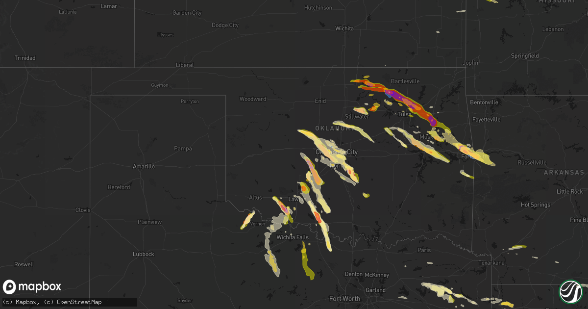
Hail Map in Oklahoma on May 8, 2026
Get this storm
May 8 map
$229
one time, instant access
Download today. No call, no setup
Keep the $229
Bought the map and want the full workflow? Apply the entire $229 to a subscription within 7 days. None of it is wasted.
Every map, not just this one
This buys you this map. Subscription and you get every map we run, in the markets you choose from a few cities to whole states to nationwide. Plus real-time alerts the moment a storm fires.
Contact data
Name, contact info, occupancy, even credit band for addresses in the footprint. You go from where it hit to who to call.
Become the source they trust
Unlimited branding weather history reports on demand. You already have the documented answer ready for the property owner, and you are the one who showed up with it.
Property data and RoofTrace estimates
Pull up any address you have got, its value and the exact code rules for that jurisdiction, straight from One Click Code. Then RoofTrace estimates the squares, pitch, and roof value, priced the way you price.
Storm reports in Oklahoma
Oklahoma
| Date | Description |
|---|---|
| 05/08/20266:59 PM CDT | A local report indicates 1.75 inch wind near 1 SW Chickasha |
| 05/08/20266:57 PM CDT | A local report indicates 1.50 inch wind near 1 SW Chickasha |
| 05/08/20266:56 PM CDT | Reported 1 mile north of wagoner on highway 69. |
| 05/08/20266:55 PM CDT | Relayed via spotter network. Time of occurrence revised according to radar. |
| 05/08/20266:55 PM CDT | Winds gusting 60-70mph as well. |
| 05/08/20266:44 PM CDT | A local report indicates 1.75 inch wind near 3 E Verden |
| 05/08/20266:40 PM CDT | A local report indicates 2.00 inch wind near Chattanooga |
| 05/08/20266:39 PM CDT | A local report indicates 2.75 inch wind near Chattanooga |
| 05/08/20266:38 PM CDT | Time estimated from radar. |
| 05/08/20266:35 PM CDT | Report from mping: ping pong ball |
| 05/08/20266:34 PM CDT | Report from mping: golf ball |
| 05/08/20266:33 PM CDT | A local report indicates 1.75 inch wind near Chattanooga |
| 05/08/20266:32 PM CDT | Hail covering the roadway. Near intersection of 600 road and 425 road on the mayes and rogers county line. Photo shared by emergency management. Time estimated from rad |
| 05/08/20266:31 PM CDT | A local report indicates 1.00 inch wind near Chattanooga |
| 05/08/20266:30 PM CDT | A local report indicates 1.00 inch wind near 2 ESE Tulsa |
| 05/08/20266:30 PM CDT | A local report indicates 1.00 inch wind near 5 NE Verden |
| 05/08/20266:28 PM CDT | A local report indicates 1.00 inch wind near 1 SW Valley Brook |
| 05/08/20266:28 PM CDT | A local report indicates 1.50 inch wind near 1 NNW Inola |
| 05/08/20266:26 PM CDT | Report from mping: quarter |
| 05/08/20266:25 PM CDT | A local report indicates 1.00 inch wind near 4 W Moore |
| 05/08/20266:25 PM CDT | A local report indicates 1.00 inch wind near 3 SSW Moore |
| 05/08/20266:23 PM CDT | A local report indicates 1.00 inch wind near 1 WSW Moore |
| 05/08/20266:22 PM CDT | A local report indicates 1.00 inch wind near 2 SE Valley Brook |
| 05/08/20266:19 PM CDT | A local report indicates 1.00 inch wind near 2 SW Tinker Air Force B |
| 05/08/20266:19 PM CDT | A local report indicates 1.00 inch wind near 3 W Moore |
| 05/08/20266:16 PM CDT | A local report indicates 1.50 inch wind near 6 N Newcastle |
| 05/08/20266:15 PM CDT | A local report indicates 1.00 inch wind near 3 E Verdigris |
| 05/08/20266:15 PM CDT | A local report indicates 1.00 inch wind near 2 E Valley Brook |
| 05/08/20266:12 PM CDT | A local report indicates 1.00 inch wind near Verdigris |
| 05/08/20266:11 PM CDT | Report from mping: ping pong ball |
| 05/08/20266:11 PM CDT | A local report indicates 1.00 inch wind near 2 NE Moore |
| 05/08/20266:09 PM CDT | Report from mping: quarter |
| 05/08/20266:07 PM CDT | A local report indicates 1.00 inch wind near 5 E Mustang |
| 05/08/20266:06 PM CDT | A local report indicates 1.25 inch wind near 2 N Mustang |
| 05/08/20266:06 PM CDT | A local report indicates 1.25 inch wind near 4 E Mustang |
| 05/08/20266:00 PM CDT | A local report indicates 1.75 inch wind near 3 SW Yukon |
| 05/08/20266:00 PM CDT | A local report indicates 1.00 inch wind near 4 E Mustang |
| 05/08/20265:59 PM CDT | Report from mping: quarter |
| 05/08/20265:58 PM CDT | Report from mping: hen egg |
| 05/08/20265:55 PM CDT | Report from mping: quarter |
| 05/08/20265:55 PM CDT | Report from mping: half dollar |
| 05/08/20265:54 PM CDT | Report from mping: quarter |
| 05/08/20265:54 PM CDT | Report from mping: hen egg |
| 05/08/20265:54 PM CDT | Reported near 106th street north and 145th east avenue. Relayed by broadcast media. |
| 05/08/20265:53 PM CDT | Report from mping: half dollar |
| 05/08/20265:53 PM CDT | Relayed by newton county missouri emergency management. Slightly larger than a golf ball 2 miles east of the limestone fire station. |
| 05/08/20265:52 PM CDT | Report from mping: half dollar |
| 05/08/20265:52 PM CDT | Report from mping: golf ball |
| 05/08/20265:51 PM CDT | Report from mping: half dollar |
| 05/08/20265:50 PM CDT | Report from mping: golf ball |
| 05/08/20265:50 PM CDT | A local report indicates 1.00 inch wind near 2 N Mustang |
| 05/08/20265:50 PM CDT | Report from mping: quarter |
| 05/08/20265:49 PM CDT | A local report indicates 1.00 inch wind near 1 S Yukon |
| 05/08/20265:48 PM CDT | A local report indicates 1.75 inch wind near 3 SSE Yukon |
| 05/08/20265:47 PM CDT | A local report indicates 1.75 inch wind near 3 SW Yukon |
| 05/08/20265:46 PM CDT | Report from mping: half dollar |
| 05/08/20265:45 PM CDT | Powerlines downed between 86th and 96th street north on garnett. Also a large tree snapped in half on north elm and owasso expressway just south of the documented locat |
| 05/08/20265:45 PM CDT | Third of a tree downed. Time estimated from radar. |
| 05/08/20265:41 PM CDT | Quarter hail at 136th street north and highway 75. |
| 05/08/20265:40 PM CDT | Yukon mesonet. |
| 05/08/20265:39 PM CDT | Report from mping: golf ball |
| 05/08/20265:39 PM CDT | Report from mping: quarter |
| 05/08/20265:37 PM CDT | Report from mping: quarter |
| 05/08/20265:36 PM CDT | Report from mping: ping pong ball |
| 05/08/20265:36 PM CDT | A local report indicates 1.00 inch wind near Guthrie |
| 05/08/20265:35 PM CDT | Quite a bit of hail up to the size of quarters. |
| 05/08/20265:32 PM CDT | Report from mping: quarter |
| 05/08/20265:31 PM CDT | Quarter to half dollar size hail on the osage and tulsa county line just south of highway 20. |
| 05/08/20265:30 PM CDT | A local report indicates 1.75 inch wind near 4 NE Skiatook |
| 05/08/20265:27 PM CDT | Time estimated from radar. |
| 05/08/20265:24 PM CDT | Report from mping: quarter |
| 05/08/20265:05 PM CDT | Hail lasted about 20 minutes... Tree limbs down around the area as well. |
| 05/08/20265:02 PM CDT | A local report indicates 1.50 inch wind near Coyle |
| 05/08/20265:00 PM CDT | A local report indicates 1.00 inch wind near 3 W Langston |
| 05/08/20264:46 PM CDT | Media storm tracker report. |
| 05/08/20264:43 PM CDT | Golf balls and slightly larger hail reported in wynona... Along with estimated 60 mph winds. |
| 05/08/20264:40 PM CDT | Measured by the wynona oklahoma mesonet station. Gust from the northwest. |
| 05/08/20263:30 PM CDT | Golf ball to occasional hen egg sized hail in burbank. Reported to almost cover the ground. |
| 05/08/20262:38 PM CDT | Report from mping: ping pong ball |
| 05/07/202610:00 PM CDT | A local report indicates 1.00 inch wind near Poteau |
| 05/07/20269:50 PM CDT | Relayed via spotter network. |
| 05/07/20269:49 PM CDT | Reported at highway 75 and birch road. |
| 05/07/20269:35 PM CDT | Picture from x. Time estimated from radar. |
| 05/07/20269:03 PM CDT | A local report indicates 1.00 inch wind near 2 SW Comanche |
| 05/07/20268:59 PM CDT | A local report indicates 1.00 inch wind near 2 SW Comanche |
| 05/07/20268:58 PM CDT | A local report indicates 1.00 inch wind near Roland |
| 05/07/20268:50 PM CDT | Time estimated via radar. |
| 05/07/20268:49 PM CDT | Picture of hail damage to a vehicle relayed from broadcast media. Hail was estimated to be tennis ball size. Time approximated from ksrx radar. |
| 05/07/20268:49 PM CDT | Picture of hail damage to a vehicle relayed by broadcast media. Hail was estimated to be tennis ball size. Time approximated from ksrx radar. |
| 05/07/20268:42 PM CDT | Up to golf ball sized. |
| 05/07/20268:05 PM CDT | Estimated 60 mph winds. Power out. Tree debris of unknown size throughout the area. Time estimated from radar. |
| 05/07/20268:00 PM CDT | On 340 road just south of liberty road. Stripped trees in the area. Time estimated from radar. |
| 05/07/20267:55 PM CDT | A local report indicates 1.25 inch wind near 3 S Fletcher |
| 05/07/20267:52 PM CDT | A local report indicates 1.50 inch wind near 1 E Elgin |
| 05/07/20267:50 PM CDT | A local report indicates 1.75 inch wind near 2 N Elgin |
| 05/07/20267:49 PM CDT | A local report indicates 1.50 inch wind near 2 NE Elgin |
| 05/07/20267:48 PM CDT | Hail near highway 75 and hectorville rd. |
| 05/07/20267:17 PM CDT | Report from mping: hen egg+ |
| 05/07/20267:13 PM CDT | Report from mping: ping pong ball |
| 05/07/20267:07 PM CDT | A local report indicates 1.75 inch wind near Chickasha |
| 05/07/20267:07 PM CDT | Report from mping: quarter |
| 05/07/20267:06 PM CDT | A local report indicates 1.25 inch wind near 1 SSE Chickasha |
| 05/07/20267:05 PM CDT | A local report indicates 2.50 inch wind near 2 WSW Chickasha |
| 05/07/20267:05 PM CDT | A local report indicates 2.50 inch wind near 5 SW Etowah |
| 05/07/20267:03 PM CDT | A local report indicates 2.75 inch wind near Etowah |
| 05/07/20267:03 PM CDT | A local report indicates 1.50 inch wind near 3 W Etowah |
| 05/07/20267:02 PM CDT | Report from mping: golf ball |
| 05/07/20267:02 PM CDT | A local report indicates 1.75 inch wind near 3 SW Etowah |
| 05/07/20267:02 PM CDT | A local report indicates 1.00 inch wind near 3 SW Etowah |
| 05/07/20267:01 PM CDT | A local report indicates 1.25 inch wind near 3 W Etowah |
All States Impacted by Hail Map on May 8, 2026
Cities Impacted by Hail Map on May 8, 2026
- Livingston, TX
- Glenmora, LA
- Moscow, TX
- Onalaska, TX
- Forest Hill, LA
- Cheneyville, LA
- Lecompte, LA
- Trinity, TX
- Ville Platte, LA
- Bunkie, LA
- Saint Landry, LA
- Cottonport, LA
- Evergreen, LA
- Ventress, LA
- Jarreau, LA
- Saint Francisville, LA
- Jackson, LA
- Plaucheville, LA
- Simmesport, LA
- Lettsworth, LA
- Batchelor, LA
- Morrow, LA
- Slaughter, LA
- Ethel, LA
- Melville, LA
- Clinton, LA
- Greensburg, LA
- Kentwood, LA
- Amite, LA
- Wilson, LA
- Fluker, LA
- Bogalusa, LA
- Poplarville, MS
- Franklinton, LA
- Mount Hermon, LA
- Lumberton, MS
- Angie, LA
- Wiggins, MS
- Perkinston, MS
- Lucedale, MS
- Wilmer, AL
- Semmes, AL
- Eight Mile, AL
- Chunchula, AL
- Bay Minette, AL
- McDavid, FL
- Molino, FL
- Ponca City, OK
- Kaw City, OK
- Shidler, OK
- Burbank, OK
- Newkirk, OK
- Boutte, LA
- Paradis, LA
- Hahnville, LA
- Thibodaux, LA
- Des Allemands, LA
- Luling, LA
- Destrehan, LA
- Norco, LA
- Saint Rose, LA
- Ama, LA
- Jay, FL
- Cedar Vale, KS
- Milton, FL
- Fairfax, OK
- Westwego, LA
- Palatka, FL
- Marrero, LA
- Braithwaite, LA
- Harvey, LA
- Belle Chasse, LA
- Marianna, FL
- Greenwood, FL
- East Palatka, FL
- Raceland, LA
- La Place, LA
- Wynona, OK
- Pawhuska, OK
- Marathon, TX
- Sneads, FL
- Grand Ridge, FL
- Crescent, OK
- Guthrie, OK
- Mulhall, OK
- Watonga, OK
- Donalsonville, GA
- Terrell, TX
- Wills Point, TX
- Omega, OK
- Kingfisher, OK
- Barnsdall, OK
- Marland, OK
- Cairo, GA
- Okarche, OK
- Coyle, OK
- Skiatook, OK
- Crescent City, FL
- Ochlocknee, GA
- Seville, FL
- Georgetown, FL
- Perkins, OK
- El Reno, OK
- Ramona, OK
- La Cygne, KS
- Amsterdam, MO
- Calumet, OK
- Pierson, FL
- Fort Stockton, TX
- Amoret, MO
- Butler, MO
- Collinsville, OK
- Yukon, OK
- Flagler Beach, FL
- Ormond Beach, FL
- Bunnell, FL
- Ralston, OK
- Wellston, OK
- Morrison, OK
- Glencoe, OK
- Stillwater, OK
- Piedmont, OK
- Owasso, OK
- Sperry, OK
- Oklahoma City, OK
- Pawnee, OK
- Snyder, OK
- Frederick, OK
- Tryon, OK
- De Leon Springs, FL
- Elk City, KS
- Oologah, OK
- Edmond, OK
- Carney, OK
- Palm Coast, FL
- Hinton, OK
- Perry, OK
- Indiahoma, OK
- Claremore, OK
- Catoosa, OK
- Binger, OK
- Minco, OK
- Mustang, OK
- Chandler, OK
- Tulsa, OK
- Agra, OK
- Prue, OK
- Maramec, OK
- Yale, OK
- Hominy, OK
- Lookeba, OK
- Fort Scott, KS
- Fulton, KS
- Montrose, MO
- Bethany, OK
- Wheatland, OK
- Cleveland, OK
- Jennings, OK
- Anadarko, OK
- Inola, OK
- Davenport, OK
- Daytona Beach, FL
- Appleton City, MO
- Loveland, OK
- Deland, FL
- Sand Springs, OK
- Galesburg, KS
- Chattanooga, OK
- Newcastle, OK
- Norman, OK
- Pocasset, OK
- Stroud, OK
- Broken Arrow, OK
- Union City, OK
- Tuttle, OK
- Spencer, OK
- Choctaw, OK
- Port Orange, FL
- Chickasha, OK
- Osage, OK
- Osceola, MO
- Verden, OK
- Wagoner, OK
- Coweta, OK
- Chouteau, OK
- Fargo, GA
- Blanchard, OK
- New Smyrna Beach, FL
- Erie, KS
- Noble, OK
- Lexington, OK
- Walters, OK
- Walnut, KS
- Locust Grove, OK
- Pryor, OK
- Newalla, OK
- Ninnekah, OK
- Hulbert, OK
- Macomb, OK
- Wanette, OK
- Grandfield, OK
- Devol, OK
- Randlett, OK
- Farlington, KS
- Hepler, KS
- Apache, OK
- Cement, OK
- Washington, OK
- Rush Springs, OK
- Bradley, OK
- Porter, OK
- Purcell, OK
- Tecumseh, OK
- Muskogee, OK
- Fort Gibson, OK
- Tahlequah, OK
- Cyril, OK
- Mounds, OK
- Wayne, OK
- Fletcher, OK
- Elgin, OK
- Braggs, OK
- Beggs, OK
- Okmulgee, OK
- Park Hill, OK
- Bixby, OK
- Haskell, OK
- Byars, OK
- Marlow, OK
- Kirbyville, TX
- Morris, OK
- Boynton, OK
- Lawton, OK
- Fort Sill, OK
- Jasper, TX
- Council Hill, OK
- Oktaha, OK
- Roff, OK
- Bunch, OK
- Sallisaw, OK
- Ada, OK
- Stratford, OK
- Bristow, OK
- Newton, TX
- Cookson, OK
- Vian, OK
- Gore, OK
- Sapulpa, OK
- Burkeville, TX
- Kellyville, OK
- Hope, AR
- Duncan, OK
- Cache, OK
- Fitzhugh, OK
- Muldrow, OK
- Roland, OK
- Evans, LA
- Leesville, LA
- Emmet, AR
- Checotah, OK
- Callahan, FL
- Wiergate, TX
- Faxon, OK
- Comanche, OK
- Warner, OK
- Porum, OK
- Van Buren, AR
- Arkoma, OK
- Fort Smith, AR
- Prescott, AR
- Anacoco, LA
- Odell, TX
- Geronimo, OK
- Vernon, TX
- Yulee, FL
- Rosston, AR
- Chillicothe, TX
- Waurika, OK
- Webbers Falls, OK
- Stigler, OK
- Loco, OK
- Stephens, AR
- Fulton, AR
- Lavaca, AR
- Barling, AR
- Charleston, AR
- Alma, AR
- Keota, OK
- Call, TX
- Bon Wier, TX
- Rudy, AR
- Cedarville, AR
- Quanah, TX
- Ryan, OK
- Henryetta, OK
- Deport, TX
- Lake Creek, TX
- Merryville, LA
- Magazine, AR
- Booneville, AR
- Branch, AR
- Shady Point, OK
- Wolfe City, TX
- Hampton, AR
- Poteau, OK
- Ringling, OK
- Davidson, OK
- Crowell, TX
- Burkburnett, TX
- Nocona, TX
- Hartford, AR
- Bokoshe, OK
- Singer, LA
- Deridder, LA
- Harrold, TX
- Electra, TX
- Ladonia, TX
- Henrietta, TX
- Wichita Falls, TX
- Iowa Park, TX
- Saint Jo, TX
- Montague, TX
- Sulphur Springs, TX
- Como, TX
- Longville, LA
- Pickton, TX
- Moreauville, LA
- Greenville, TX
- Campbell, TX
- Monterey, LA
- Dry Creek, LA
- Yantis, TX
- Winnsboro, TX
- Scroggins, TX
- Mittie, LA
- Leesburg, TX
- Kinder, LA
- Oberlin, LA
- Portland, AR
- Holliday, TX
- Seymour, TX
- Bellevue, TX
- Pittsburg, TX
- Windthorst, TX
- Scotland, TX
- Mamou, LA
- Ore City, TX
- Quitman, TX
- Jacksboro, TX
- Bowie, TX
- Newcastle, TX
- Olney, TX
- Avinger, TX
- Lone Star, TX
- Gilmer, TX
- Jefferson, TX
- Crossett, AR
- Bastrop, LA
- Eunice, LA
- Saltillo, TX
- Diana, TX
- Perrin, TX
- Jones, LA
- Hamburg, AR
- Bonita, LA
- Karnack, TX
- Opelousas, LA
- Washington, LA
- Port Barre, LA
- Big Sandy, TX
- Oak Grove, LA
- Fordoche, LA
- Lottie, LA
- Krotz Springs, LA
- Maringouin, LA
- Livonia, LA
- Mooringsport, LA
- Benton, LA
- Belcher, LA
- Shreveport, LA
- Oil City, LA
- Longview, TX
- Vivian, LA
- Harleton, TX
- Marshall, TX
- Lake Providence, LA
- Rolling Fork, MS
- Hallsville, TX
- Bossier City, LA
- Haughton, LA
- Oscar, LA
- Minden, LA
- Grosse Tete, LA
- Mayersville, MS
- Princeton, LA
- Sibley, LA
- Doyline, LA
- Dubberly, LA
- Port Allen, LA
- Heflin, LA
- Rosedale, LA
- Waskom, TX
- Castor, LA
- Gibsland, LA
- Jamestown, LA
- Barksdale Afb, LA
- Durant, MS
- Bienville, LA
- Mansura, LA
- Goodman, MS
- Sallis, MS
- Laredo, TX
- Jonesboro, LA
- Chatham, LA
- San Ygnacio, TX
- Saline, LA
- Zapata, TX
- Columbia, LA
- Grayson, LA
- Hebbronville, TX
- Eros, LA
- Winnsboro, LA
- Ponchatoula, LA
- Wisner, LA
- Fort Necessity, LA
- Sicily Island, LA
- Gilbert, LA
- Saint Joseph, LA
- Liberty, MS
- Magnolia, MS
- Osyka, MS
- Woodville, MS
- New Roads, LA
- Greenwood, LA
- Zachary, LA
- Roseland, LA
- Denham Springs, LA
- Vera, OK


