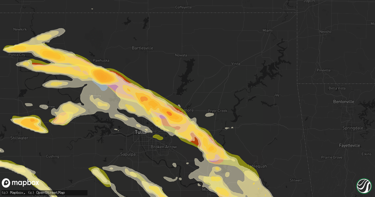
Hail Map in Claremore, OK on May 8, 2026
Get this storm
May 8 map
$229
one time, instant access
Download today. No call, no setup
Keep the $229
Bought the map and want the full workflow? Apply the entire $229 to a subscription within 7 days. None of it is wasted.
Every map, not just this one
This buys you this map. Subscription and you get every map we run, in the markets you choose from a few cities to whole states to nationwide. Plus real-time alerts the moment a storm fires.
Contact data
Name, contact info, occupancy, even credit band for addresses in the footprint. You go from where it hit to who to call.
Become the source they trust
Unlimited branding weather history reports on demand. You already have the documented answer ready for the property owner, and you are the one who showed up with it.
Property data and RoofTrace estimates
Pull up any address you have got, its value and the exact code rules for that jurisdiction, straight from One Click Code. Then RoofTrace estimates the squares, pitch, and roof value, priced the way you price.
Storm reports in Claremore, OK
Claremore, OK
| Date | Description |
|---|---|
| 05/08/20266:15 PM CDT | A local report indicates 1.00 inch wind near 3 E Verdigris |
| 05/08/20266:12 PM CDT | A local report indicates 1.00 inch wind near Verdigris |
| 05/08/20266:11 PM CDT | Report from mping: ping pong ball |
| 05/08/20266:09 PM CDT | Report from mping: quarter |
| 05/08/20265:55 PM CDT | Report from mping: half dollar |
| 05/08/20265:53 PM CDT | Relayed by newton county missouri emergency management. Slightly larger than a golf ball 2 miles east of the limestone fire station. |
All States Impacted by Hail Map on May 8, 2026
All Cities Impacted by Hail Map on May 8, 2026
- Livingston, TX
- Glenmora, LA
- Moscow, TX
- Onalaska, TX
- Forest Hill, LA
- Cheneyville, LA
- Lecompte, LA
- Trinity, TX
- Ville Platte, LA
- Bunkie, LA
- Saint Landry, LA
- Cottonport, LA
- Evergreen, LA
- Ventress, LA
- Jarreau, LA
- Saint Francisville, LA
- Jackson, LA
- Plaucheville, LA
- Simmesport, LA
- Lettsworth, LA
- Batchelor, LA
- Morrow, LA
- Slaughter, LA
- Ethel, LA
- Melville, LA
- Clinton, LA
- Greensburg, LA
- Kentwood, LA
- Amite, LA
- Wilson, LA
- Fluker, LA
- Bogalusa, LA
- Poplarville, MS
- Franklinton, LA
- Mount Hermon, LA
- Lumberton, MS
- Angie, LA
- Wiggins, MS
- Perkinston, MS
- Lucedale, MS
- Wilmer, AL
- Semmes, AL
- Eight Mile, AL
- Chunchula, AL
- Bay Minette, AL
- McDavid, FL
- Molino, FL
- Ponca City, OK
- Kaw City, OK
- Shidler, OK
- Burbank, OK
- Newkirk, OK
- Boutte, LA
- Paradis, LA
- Hahnville, LA
- Thibodaux, LA
- Des Allemands, LA
- Luling, LA
- Destrehan, LA
- Norco, LA
- Saint Rose, LA
- Ama, LA
- Jay, FL
- Cedar Vale, KS
- Milton, FL
- Fairfax, OK
- Westwego, LA
- Palatka, FL
- Marrero, LA
- Braithwaite, LA
- Harvey, LA
- Belle Chasse, LA
- Marianna, FL
- Greenwood, FL
- East Palatka, FL
- Raceland, LA
- La Place, LA
- Wynona, OK
- Pawhuska, OK
- Marathon, TX
- Sneads, FL
- Grand Ridge, FL
- Crescent, OK
- Guthrie, OK
- Mulhall, OK
- Watonga, OK
- Donalsonville, GA
- Terrell, TX
- Wills Point, TX
- Omega, OK
- Kingfisher, OK
- Barnsdall, OK
- Marland, OK
- Cairo, GA
- Okarche, OK
- Coyle, OK
- Skiatook, OK
- Crescent City, FL
- Ochlocknee, GA
- Seville, FL
- Georgetown, FL
- Perkins, OK
- El Reno, OK
- Ramona, OK
- La Cygne, KS
- Amsterdam, MO
- Calumet, OK
- Pierson, FL
- Fort Stockton, TX
- Amoret, MO
- Butler, MO
- Collinsville, OK
- Yukon, OK
- Flagler Beach, FL
- Ormond Beach, FL
- Bunnell, FL
- Ralston, OK
- Wellston, OK
- Morrison, OK
- Glencoe, OK
- Stillwater, OK
- Piedmont, OK
- Owasso, OK
- Sperry, OK
- Oklahoma City, OK
- Pawnee, OK
- Snyder, OK
- Frederick, OK
- Tryon, OK
- De Leon Springs, FL
- Elk City, KS
- Oologah, OK
- Edmond, OK
- Carney, OK
- Palm Coast, FL
- Hinton, OK
- Perry, OK
- Indiahoma, OK
- Claremore, OK
- Catoosa, OK
- Binger, OK
- Minco, OK
- Mustang, OK
- Chandler, OK
- Tulsa, OK
- Agra, OK
- Prue, OK
- Maramec, OK
- Yale, OK
- Hominy, OK
- Lookeba, OK
- Fort Scott, KS
- Fulton, KS
- Montrose, MO
- Bethany, OK
- Wheatland, OK
- Cleveland, OK
- Jennings, OK
- Anadarko, OK
- Inola, OK
- Davenport, OK
- Daytona Beach, FL
- Appleton City, MO
- Loveland, OK
- Deland, FL
- Sand Springs, OK
- Galesburg, KS
- Chattanooga, OK
- Newcastle, OK
- Norman, OK
- Pocasset, OK
- Stroud, OK
- Broken Arrow, OK
- Union City, OK
- Tuttle, OK
- Spencer, OK
- Choctaw, OK
- Port Orange, FL
- Chickasha, OK
- Osage, OK
- Osceola, MO
- Verden, OK
- Wagoner, OK
- Coweta, OK
- Chouteau, OK
- Fargo, GA
- Blanchard, OK
- New Smyrna Beach, FL
- Erie, KS
- Noble, OK
- Lexington, OK
- Walters, OK
- Walnut, KS
- Locust Grove, OK
- Pryor, OK
- Newalla, OK
- Ninnekah, OK
- Hulbert, OK
- Macomb, OK
- Wanette, OK
- Grandfield, OK
- Devol, OK
- Randlett, OK
- Farlington, KS
- Hepler, KS
- Apache, OK
- Cement, OK
- Washington, OK
- Rush Springs, OK
- Bradley, OK
- Porter, OK
- Purcell, OK
- Tecumseh, OK
- Muskogee, OK
- Fort Gibson, OK
- Tahlequah, OK
- Cyril, OK
- Mounds, OK
- Wayne, OK
- Fletcher, OK
- Elgin, OK
- Braggs, OK
- Beggs, OK
- Okmulgee, OK
- Park Hill, OK
- Bixby, OK
- Haskell, OK
- Byars, OK
- Marlow, OK
- Kirbyville, TX
- Morris, OK
- Boynton, OK
- Lawton, OK
- Fort Sill, OK
- Jasper, TX
- Council Hill, OK
- Oktaha, OK
- Roff, OK
- Bunch, OK
- Sallisaw, OK
- Ada, OK
- Stratford, OK
- Bristow, OK
- Newton, TX
- Cookson, OK
- Vian, OK
- Gore, OK
- Sapulpa, OK
- Burkeville, TX
- Kellyville, OK
- Hope, AR
- Duncan, OK
- Cache, OK
- Fitzhugh, OK
- Muldrow, OK
- Roland, OK
- Evans, LA
- Leesville, LA
- Emmet, AR
- Checotah, OK
- Callahan, FL
- Wiergate, TX
- Faxon, OK
- Comanche, OK
- Warner, OK
- Porum, OK
- Van Buren, AR
- Arkoma, OK
- Fort Smith, AR
- Prescott, AR
- Anacoco, LA
- Odell, TX
- Geronimo, OK
- Vernon, TX
- Yulee, FL
- Rosston, AR
- Chillicothe, TX
- Waurika, OK
- Webbers Falls, OK
- Stigler, OK
- Loco, OK
- Stephens, AR
- Fulton, AR
- Lavaca, AR
- Barling, AR
- Charleston, AR
- Alma, AR
- Keota, OK
- Call, TX
- Bon Wier, TX
- Rudy, AR
- Cedarville, AR
- Quanah, TX
- Ryan, OK
- Henryetta, OK
- Deport, TX
- Lake Creek, TX
- Merryville, LA
- Magazine, AR
- Booneville, AR
- Branch, AR
- Shady Point, OK
- Wolfe City, TX
- Hampton, AR
- Poteau, OK
- Ringling, OK
- Davidson, OK
- Crowell, TX
- Burkburnett, TX
- Nocona, TX
- Hartford, AR
- Bokoshe, OK
- Singer, LA
- Deridder, LA
- Harrold, TX
- Electra, TX
- Ladonia, TX
- Henrietta, TX
- Wichita Falls, TX
- Iowa Park, TX
- Saint Jo, TX
- Montague, TX
- Sulphur Springs, TX
- Como, TX
- Longville, LA
- Pickton, TX
- Moreauville, LA
- Greenville, TX
- Campbell, TX
- Monterey, LA
- Dry Creek, LA
- Yantis, TX
- Winnsboro, TX
- Scroggins, TX
- Mittie, LA
- Leesburg, TX
- Kinder, LA
- Oberlin, LA
- Portland, AR
- Holliday, TX
- Seymour, TX
- Bellevue, TX
- Pittsburg, TX
- Windthorst, TX
- Scotland, TX
- Mamou, LA
- Ore City, TX
- Quitman, TX
- Jacksboro, TX
- Bowie, TX
- Newcastle, TX
- Olney, TX
- Avinger, TX
- Lone Star, TX
- Gilmer, TX
- Jefferson, TX
- Crossett, AR
- Bastrop, LA
- Eunice, LA
- Saltillo, TX
- Diana, TX
- Perrin, TX
- Jones, LA
- Hamburg, AR
- Bonita, LA
- Karnack, TX
- Opelousas, LA
- Washington, LA
- Port Barre, LA
- Big Sandy, TX
- Oak Grove, LA
- Fordoche, LA
- Lottie, LA
- Krotz Springs, LA
- Maringouin, LA
- Livonia, LA
- Mooringsport, LA
- Benton, LA
- Belcher, LA
- Shreveport, LA
- Oil City, LA
- Longview, TX
- Vivian, LA
- Harleton, TX
- Marshall, TX
- Lake Providence, LA
- Rolling Fork, MS
- Hallsville, TX
- Bossier City, LA
- Haughton, LA
- Oscar, LA
- Minden, LA
- Grosse Tete, LA
- Mayersville, MS
- Princeton, LA
- Sibley, LA
- Doyline, LA
- Dubberly, LA
- Port Allen, LA
- Heflin, LA
- Rosedale, LA
- Waskom, TX
- Castor, LA
- Gibsland, LA
- Jamestown, LA
- Barksdale Afb, LA
- Durant, MS
- Bienville, LA
- Mansura, LA
- Goodman, MS
- Sallis, MS
- Laredo, TX
- Jonesboro, LA
- Chatham, LA
- San Ygnacio, TX
- Saline, LA
- Zapata, TX
- Columbia, LA
- Grayson, LA
- Hebbronville, TX
- Eros, LA
- Winnsboro, LA
- Ponchatoula, LA
- Wisner, LA
- Fort Necessity, LA
- Sicily Island, LA
- Gilbert, LA
- Saint Joseph, LA
- Liberty, MS
- Magnolia, MS
- Osyka, MS
- Woodville, MS
- New Roads, LA
- Greenwood, LA
- Zachary, LA
- Roseland, LA
- Denham Springs, LA
- Vera, OK


