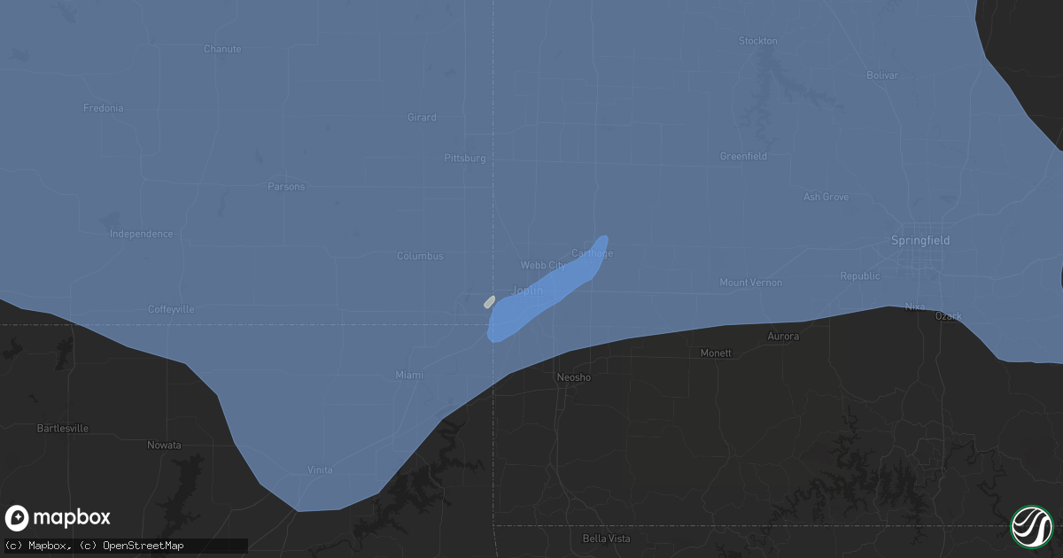
Hail Map in Joplin, MO on May 6, 2024
Get this storm
May 6 map
$229
one time, instant access
Download today. No call, no setup
Keep the $229
Bought the map and want the full workflow? Apply the entire $229 to a subscription within 7 days. None of it is wasted.
Every map, not just this one
This buys you this map. Subscription and you get every map we run, in the markets you choose from a few cities to whole states to nationwide. Plus real-time alerts the moment a storm fires.
Contact data
Name, contact info, occupancy, even credit band for addresses in the footprint. You go from where it hit to who to call.
Become the source they trust
Unlimited branding weather history reports on demand. You already have the documented answer ready for the property owner, and you are the one who showed up with it.
Property data and RoofTrace estimates
Pull up any address you have got, its value and the exact code rules for that jurisdiction, straight from One Click Code. Then RoofTrace estimates the squares, pitch, and roof value, priced the way you price.
Storm reports in Joplin, MO
Joplin, MO
| Date | Description |
|---|---|
| 05/06/202411:40 AM CDT | Via social media pictures of damage to large tree and hvac unit toppled. |
| 05/05/202411:36 PM CDT | Picture sent of a roof torn off. |
| 05/05/202411:36 PM CDT | Image via social media of a resident garage/shop collapsed. |
| 05/05/202411:36 PM CDT | Pictures via social media showing several large trees uprooted. Root base was approximately 10-15 feet across. Time estimated via radar. Location approximated around tr |
| 05/05/202411:33 PM CDT | Tree on a house in newton county off suburban terrace/grand falls blvd. Time based on radar. |
| 05/05/202411:32 PM CDT | Pictures via social media of fallen gas station signs and roof material blown off of lumber yard outbuildings along rangeline rd. Time estimated via radar. |
| 05/05/202411:30 PM CDT | Handful of power lines and trees down across the joplin area. Time based on radar. |
| 05/05/202411:30 PM CDT | Report from mping 1-inch tree limbs broken... Shingles blown off. Time based on radar. |
| 05/05/202411:30 PM CDT | Received images via email of several trees uprooted and branches snapped. |
| 05/05/202411:30 PM CDT | Delayed report. Large tree toppled over. |
| 05/05/202411:30 PM CDT | Delayed report. Via social media pictures of damage to large tree and hvac unit toppled. |
| 05/05/202411:29 PM CDT | Nws storm survey found a ef-1 tornado with an intermittent damage path across the southeast and east side of joplin into duquesene. Maximum winds were estimated at 95 m |
| 05/05/202411:28 PM CDT | Newton county has storm damage off coyote/bluff dr north of i444 and a roof blown off a new construction on highway 43 and elm st. |
| 05/05/202411:15 PM CDT | Images via social media of several trees uprooted and large branches down. |
All States Impacted by Hail Map on May 6, 2024
All Cities Impacted by Hail Map on May 6, 2024
- Hoxie, KS
- Hermosa, SD
- Caputa, SD
- Jennings, KS
- Clayton, KS
- Norton, KS
- Penokee, KS
- Morland, KS
- Wilsonville, NE
- Hendley, NE
- Beaver City, NE
- Hill City, KS
- Lenora, KS
- Almena, KS
- Logan, KS
- Edison, NE
- Oxford, NE
- Wakeeney, KS
- Collyer, KS
- Arapahoe, NE
- Hammond, MT
- Boyes, MT
- Ekalaka, MT
- Prairie View, KS
- Louisville, GA
- Phillipsburg, KS
- Newell, SD
- Bogue, KS
- Quinn, SD
- Stockton, KS
- Long Island, KS
- Blythe, GA
- Augusta, GA
- Damar, KS
- Utica, KS
- Palco, KS
- Alma, NE
- Philip, SD
- Wall, SD
- Ogallah, KS
- Ellis, KS
- Spearville, KS
- Republican City, NE
- Wright, KS
- Ford, KS
- Harlem, GA
- Grovetown, GA
- Nicholson, GA
- Jefferson, GA
- Athens, GA
- Glade, KS
- Hayesville, NC
- Dodge City, KS
- Bucklin, KS
- Plainville, KS
- Offerle, KS
- Kinsley, KS
- Morrison, TN
- Altamont, TN
- Naponee, NE
- Mud Butte, SD
- Mountain Rest, SC
- Mcminnville, TN
- Beersheba Springs, TN
- Lewis, KS
- Hull, GA
- Lebanon, TN
- Colbert, GA
- Milesville, SD
- Cherry Creek, SD
- Linden, TN
- Mount Juliet, TN
- Salem, SC
- Tamassee, SC
- Howes, SD
- Agra, KS
- Kensington, KS
- Bloomington, NE
- Smith Center, KS
- Lobelville, TN
- Centerville, TN
- Bon Aqua, TN
- Lyles, TN
- Kirwin, KS
- North Augusta, SC
- Walhalla, SC
- Pickens, SC
- Woodston, KS
- Fairview, TN
- Franklin, TN
- Primm Springs, TN
- Garfield, KS
- Larned, KS
- Franklin, NE
- Riverton, NE
- Alton, KS
- Gaylord, KS
- Hays, KS
- Bethpage, TN
- Castalian Springs, TN
- Greensburg, KS
- Hartsville, TN
- Watertown, TN
- Tallahassee, FL
- Comer, GA
- Martin, GA
- Westminster, SC
- Toccoa, GA
- Cedar, KS
- Pawnee Rock, KS
- Protection, KS
- Coldwater, KS
- Murfreesboro, TN
- Athol, KS
- Gordonsville, TN
- Carthage, TN
- Thompsons Station, TN
- Murphy, NC
- Sunset, SC
- Six Mile, SC
- Edgefield, SC
- Easley, SC
- Inavale, NE
- Saluda, SC
- Johnston, SC
- Haviland, KS
- Alzada, MT
- Ewing, NE
- Matthews, GA
- Liberty, SC
- Catharine, KS
- Brush Creek, TN
- Albert, KS
- Otis, KS
- Natoma, KS
- Riddleton, TN
- Campbell, NE
- College Grove, TN
- Duck River, TN
- Hampshire, TN
- Williamsport, TN
- Mount Pleasant, TN
- Lebanon, KS
- Faith, SD
- Dupree, SD
- Inman, NE
- Sharon, OK
- Portis, KS
- Buffalo Valley, TN
- Page, NE
- Great Bend, KS
- Bladen, NE
- Elmwood, TN
- Chestnut Mound, TN
- Arnett, OK
- Thedford, NE
- Columbia, TN
- Woodward, OK
- Arrington, TN
- Rockvale, TN
- Eagleville, TN
- Orchard, NE
- Oneill, NE
- Red Cloud, NE
- Wilmore, KS
- Hoisington, KS
- Central, SC
- Waterford, MS
- Potts Camp, MS
- Greenville, SC
- Mooreland, OK
- Blue Hill, NE
- Burr Oak, KS
- Esbon, KS
- Mankato, KS
- Guide Rock, NE
- Glenvil, NE
- Ayr, NE
- Lawrence, NE
- St John, KS
- Smithville, TN
- Pratt, KS
- Byers, KS
- Iuka, KS
- Capitol, MT
- Piedmont, SC
- Nashville, TN
- Sylvania, GA
- Fairfax, SC
- Cheyenne, OK
- Claflin, KS
- Vici, OK
- Pendleton, SC
- Anderson, SC
- Antioch, TN
- Crawford, OK
- Liberty, TN
- Dowelltown, TN
- Demorest, GA
- Seneca, SC
- Baxter, TN
- Cookeville, TN
- Coats, KS
- Waynoka, OK
- Mutual, OK
- Williamston, SC
- Hammon, OK
- Pelzer, SC
- Leedey, OK
- Gatlinburg, TN
- Sparta, TN
- Sun City, KS
- Christiana, TN
- Hermitage, TN
- Inland, NE
- Hastings, NE
- Trumbull, NE
- Superior, NE
- Fairfield, NE
- Giltner, NE
- Deweese, NE
- Harvard, NE
- Nelson, NE
- Clay Center, NE
- Ellinwood, KS
- Holyrood, KS
- Bushton, KS
- Lorraine, KS
- Simpsonville, SC
- Smoaks, SC
- Ruffin, SC
- Gray Court, SC
- Fountain Inn, SC
- Stafford, KS
- Macksville, KS
- Woodruff, SC
- Only, TN
- McEwen, TN
- Nunnelly, TN
- Silver Point, TN
- Walling, TN
- Luray, SC
- Estill, SC
- Chester, OK
- Bell Buckle, TN
- Fairview, OK
- Alva, OK
- Taloga, OK
- Edgar, NE
- Camargo, OK
- Cosby, TN
- Sevierville, TN
- Turon, KS
- Beechgrove, TN
- Henderson, NE
- Stromsburg, NE
- Sutton, NE
- Bradshaw, NE
- Aurora, NE
- Benedict, NE
- Oak, NE
- Polk, NE
- Saronville, NE
- Hampton, NE
- Bradyville, TN
- Manchester, TN
- Geneva, NE
- Shickley, NE
- Ong, NE
- Davenport, NE
- Grafton, NE
- McCool Junction, NE
- Ruskin, NE
- Fairmont, NE
- York, NE
- Deshler, NE
- Ellsworth, KS
- Sylvia, KS
- Lincoln, KS
- Lyons, KS
- Quebeck, TN
- Doyle, TN
- Enoree, SC
- Mauldin, SC
- Plevna, KS
- Seiling, OK
- Ridgeland, SC
- Newport, TN
- Oakwood, OK
- Kanopolis, KS
- Walterboro, SC
- Winnsboro, SC
- Spencer, TN
- Abbyville, KS
- Sterling, KS
- Cleo Springs, OK
- Aline, OK
- Orangeburg, SC
- Cottageville, SC
- Ridgeville, SC
- Union, SC
- Clinton, SC
- Osceola, NE
- Gresham, NE
- Shelby, NE
- Waco, NE
- Carmen, OK
- Belvidere, NE
- Bruning, NE
- Strang, NE
- Carleton, NE
- Hebron, NE
- Hardy, NE
- Helena, OK
- Canton, OK
- Saint George, SC
- Tescott, KS
- Brookville, KS
- Whitmire, SC
- Commerce, GA
- Concordia, KS
- Aurora, KS
- Butler, OK
- Sawyer, KS
- Nickerson, KS
- Bells, TN
- Gadsden, TN
- Ohiowa, NE
- Exeter, NE
- Milligan, NE
- Longdale, OK
- Southard, OK
- Belleville, KS
- Clyde, KS
- Agenda, KS
- Clifton, KS
- Goltry, OK
- Jet, OK
- Miltonvale, KS
- Minneapolis, KS
- Delphos, KS
- Guyton, GA
- Laurens, SC
- Salina, KS
- Windom, KS
- Inman, KS
- Hutchinson, KS
- Little River, KS
- Greeneville, TN
- Putnam, OK
- Marshall, NC
- Hillsboro, TN
- Nash, OK
- Pond Creek, OK
- Okeene, OK
- Isabella, OK
- Lemmon, SD
- Watonga, OK
- Mcpherson, KS
- Lindsborg, KS
- Tillman, SC
- Hardeeville, SC
- Sayre, OK
- Lucas, KS
- Osborne, KS
- Luray, KS
- Bennington, KS
- Wisner, NE
- Clay Center, KS
- Marquette, KS
- Hitchcock, OK
- Custer City, OK
- Kingfisher, OK
- Gypsum, KS
- Hettinger, ND
- Afton, TN
- Chuckey, TN
- Bloomingdale, GA
- Spring Hill, TN
- Elk City, OK
- Assaria, KS
- Galva, KS
- Solomon, KS
- Linn, KS
- Hennessey, OK
- Ames, OK
- Abilene, KS
- Hope, KS
- Drummond, OK
- Waukomis, OK
- Chapman, KS
- Enterprise, KS
- Medford, OK
- Tampa, KS
- Durham, KS
- Enid, OK
- Washington, KS
- Morganville, KS
- Rincon, GA
- Ellabell, GA
- New Cambria, KS
- Limestone, TN
- Telford, TN
- Talmage, KS
- Woodbine, KS
- Wakefield, KS
- Clinton, OK
- Arapaho, OK
- Weatherford, OK
- Junction City, KS
- Dwight, NE
- Palmer, KS
- Longford, KS
- Bison, OK
- Lewisburg, TN
- Port Wentworth, GA
- Florence, SC
- Scooba, MS
- Abbeville, SC
- Donalds, SC
- Fort Riley, KS
- Milford, KS
- Riley, KS
- Lamont, OK
- Deer Creek, OK
- Manhattan, KS
- Ogden, KS
- Randolph, KS
- Leonardville, KS
- Thomas, OK
- Odell, NE
- Wymore, NE
- Blue Springs, NE
- Weston, NE
- Prague, NE
- Valparaiso, NE
- Malmo, NE
- Honea Path, SC
- Greenleaf, KS
- Barnard, KS
- Beatrice, NE
- Chapel Hill, TN
- Lascassas, TN
- Granite Falls, NC
- Nardin, OK
- Marshall, OK
- Douglas, OK
- Fairmont, OK
- Olsburg, KS
- Blue Rapids, KS
- Colon, NE
- Cedar Bluffs, NE
- Hodges, SC
- Waterville, KS
- Barnes, KS
- Adams, NE
- Filley, NE
- Virginia, NE
- Readyville, TN
- Blackwell, OK
- Braman, OK
- Saint George, KS
- Frankfort, KS
- Westmoreland, KS
- Covington, OK
- Lucien, OK
- Orlando, OK
- Vermillion, KS
- Axtell, KS
- Ames, NE
- South Haven, KS
- Oxford, KS
- Geuda Springs, KS
- Glasco, KS
- Beloit, KS
- Cedar Vale, KS
- Taylorsville, NC
- Beverly, KS
- Ware Shoals, SC
- Oketo, KS
- Pigeon Forge, TN
- Woodbury, TN
- Perry, OK
- Waterloo, SC
- Unadilla, NE
- Newkirk, OK
- Arkansas City, KS
- Belton, SC
- Winfield, KS
- Lincoln, NE
- Bethune, SC
- Kershaw, SC
- Chase, KS
- Geary, OK
- Grenola, KS
- Cambridge, KS
- Dexter, KS
- Severy, KS
- Onaga, KS
- Rock, KS
- Baileyville, KS
- West Union, SC
- Greenfield, OK
- Loyal, OK
- Table Rock, NE
- Johnson, NE
- Humboldt, NE
- Auburn, NE
- Shidler, OK
- Geneseo, KS
- Cushing, OK
- Lenoir, NC
- Statesville, NC
- Stony Point, NC
- Dandridge, TN
- Brentwood, TN
- Syracuse, NE
- Avoca, NE
- Elmwood, NE
- Weeping Water, NE
- Lancaster, TN
- Seneca, KS
- Goff, KS
- Corning, KS
- Centralia, KS
- Home, KS
- Marysville, KS
- Summerfield, KS
- Liberty, NE
- Steinauer, NE
- Beattie, KS
- Burchard, NE
- Du Bois, NE
- Pawnee City, NE
- Green, KS
- Tecumseh, NE
- Crab Orchard, NE
- La Vista, NE
- Papillion, NE
- Omaha, NE
- Springfield, NE
- Yale, OK
- Brock, NE
- Omega, OK
- Valley, NE
- Okarche, OK
- Calumet, OK
- Elkhorn, NE
- Bennington, NE
- Cross Hill, SC
- Kennard, NE
- Bern, KS
- Sterling, NE
- Falun, KS
- Panama, NE
- Walton, NE
- Hickman, NE
- Roca, NE
- Bennet, NE
- Firth, NE
- Palmyra, NE
- Douglas, NE
- Waverly, NE
- Pickrell, NE
- Eagle, NE
- Burr, NE
- Murdock, NE
- Ceresco, NE
- Alvo, NE
- Wahoo, NE
- Ashland, NE
- Ithaca, NE
- Greenwood, NE
- Gretna, NE
- Mead, NE
- Dunbar, NE
- Manley, NE
- South Bend, NE
- Glenwood, IA
- Otoe, NE
- Nebraska City, NE
- Nehawka, NE
- Murray, NE
- Union, NE
- Yutan, NE
- Memphis, NE
- Pacific Junction, IA
- Cedar Creek, NE
- Plattsmouth, NE
- Louisville, NE
- Bellevue, NE
- Waterloo, NE
- Council Bluffs, IA
- Boys Town, NE
- Crescent, IA
- Offutt Afb, NE
- Fort Calhoun, NE
- Carter Lake, IA
- Blair, NE
- Washington, NE
- Cook, NE
- Hamburg, IA
- Lorton, NE
- Sidney, IA
- Talmage, NE
- Thurman, IA
- Percival, IA
- Tabor, IA
- Mountville, SC
- Shenandoah, IA
- Dawson, NE
- Stella, NE
- Verdon, NE
- Fort Stewart, GA
- Hiddenite, NC
- Norris, SC
- Sabetha, KS
- Oneida, KS
- Terlton, OK
- Rock Port, MO
- Brownville, NE
- Nemaha, NE
- Peru, NE
- Elk Creek, NE
- Julian, NE
- Riverton, IA
- Shubert, NE
- Morrill, KS
- Salem, NE
- Watson, MO
- Falls City, NE
- Cleveland, OK
- Logan, IA
- Honey Creek, IA
- Underwood, IA
- Malvern, IA
- Missouri Valley, IA
- Silver City, IA
- Hastings, IA
- Oakland, IA
- Randolph, IA
- McClelland, IA
- Mineola, IA
- Henderson, IA
- Minden, IA
- Emerson, IA
- Macedonia, IA
- Treynor, IA
- Carson, IA
- Neola, IA
- Imogene, IA
- Farragut, IA
- Tarkio, MO
- Westboro, MO
- Fairfax, MO
- Osage, OK
- Hominy, OK
- Townville, SC
- Arlington, NE
- Fleming, GA
- Fairfax, OK
- Pawnee, OK
- Howard, KS
- Fall River, KS
- Stillwater, OK
- Sedan, KS
- Shelby, IA
- Northboro, IA
- Coin, IA
- Craig, MO
- Blanchard, IA
- Essex, IA
- Red Oak, IA
- Hancock, IA
- Walnut, IA
- Persia, IA
- Griswold, IA
- Elliott, IA
- Avoca, IA
- Woodbine, IA
- Harlan, IA
- Earling, IA
- Panama, IA
- Dunlap, IA
- Portsmouth, IA
- Burden, KS
- Atlanta, KS
- Latham, KS
- Piedmont, KS
- Eureka, KS
- Richmond Hill, GA
- Wellsville, KS
- Barnsdall, OK
- Crescent, OK
- Moline, KS
- Elk Falls, KS
- Independence, KS
- Longton, KS
- Elk City, KS
- Caney, KS
- Niotaze, KS
- Peru, KS
- Havana, KS
- Bartlesville, OK
- Manilla, IA
- Irwin, IA
- Westphalia, IA
- Defiance, IA
- Kirkman, IA
- Brayton, IA
- Atlantic, IA
- Exira, IA
- Audubon, IA
- Marne, IA
- Kimballton, IA
- Elk Horn, IA
- Lewis, IA
- Wiota, IA
- Clarinda, IA
- Grant, IA
- Yorktown, IA
- Villisca, IA
- Corning, IA
- Cumberland, IA
- Stanton, IA
- Braddyville, IA
- College Springs, IA
- Elmo, MO
- Cleveland, NC
- Dobson, NC
- Cashion, OK
- Eudora, KS
- Fredonia, KS
- Neal, KS
- Toronto, KS
- Virgil, KS
- Neosho Falls, KS
- Buffalo, KS
- Neodesha, KS
- Yates Center, KS
- Le Roy, KS
- Benedict, KS
- Gridley, KS
- Burlington, KS
- Piqua, KS
- Cherryvale, KS
- Thayer, KS
- Chanute, KS
- Mound Valley, KS
- Coffeyville, KS
- Liberty, KS
- Tyro, KS
- Altoona, KS
- Dearing, KS
- Edna, KS
- Parsons, KS
- Dennis, KS
- Altamont, KS
- Galesburg, KS
- Humboldt, KS
- Iola, KS
- Dewey, OK
- Erie, KS
- Girard, KS
- Savonburg, KS
- McCune, KS
- Columbus, KS
- Walnut, KS
- West Mineral, KS
- Chetopa, KS
- Scammon, KS
- Saint Paul, KS
- Colony, KS
- Oswego, KS
- Mapleton, KS
- Moran, KS
- Redfield, KS
- Uniontown, KS
- Weir, KS
- Pittsburg, KS
- Mound City, KS
- Welda, KS
- Fort Scott, KS
- Kincaid, KS
- Hepler, KS
- Bronson, KS
- Farlington, KS
- Westphalia, KS
- Stark, KS
- Blue Mound, KS
- La Harpe, KS
- Elsmore, KS
- Cherokee, KS
- Centerville, KS
- Garnett, KS
- Wynona, OK
- Guthrie, OK
- Pawhuska, OK
- Mulhall, OK
- Edmond, OK
- Carroll, IA
- Wall Lake, IA
- Arcadia, IA
- Vail, IA
- Sac City, IA
- Westside, IA
- Manning, IA
- Lake View, IA
- Breda, IA
- Halbur, IA
- Aspinwall, IA
- Templeton, IA
- Auburn, IA
- Denison, IA
- Gray, IA
- Dow City, IA
- Anita, IA
- Coon Rapids, IA
- Guthrie Center, IA
- Dedham, IA
- Adair, IA
- Hamlin, IA
- Bridgewater, IA
- Carbon, IA
- Fontanelle, IA
- Nodaway, IA
- Massena, IA
- New Market, IA
- Gravity, IA
- Prescott, IA
- Shambaugh, IA
- Lenox, IA
- Skidmore, MO
- Burlington Junction, MO
- Clearmont, MO
- Rulo, NE
- Bedford, IA
- Coyle, OK
- Ochelata, OK
- Meridian, OK
- Muskogee, OK
- Dover, OK
- Skiatook, OK
- Ramona, OK
- Talala, OK
- Wagoner, OK
- Perkins, OK
- Wellston, OK
- Nowata, OK
- Delaware, OK
- Ottawa, KS
- Rantoul, KS
- Porter, OK
- Carney, OK
- Tryon, OK
- Carnegie, OK
- Fort Cobb, OK
- Galena, KS
- Locust Grove, OK
- Cordell, OK
- Roosevelt, OK
- Agra, OK
- Gracemont, OK
- Binger, OK
- Anadarko, OK
- Lidderdale, IA
- Palmer, IA
- Jolley, IA
- Rockwell City, IA
- Glidden, IA
- Fonda, IA
- Pocahontas, IA
- Lake City, IA
- Lanesboro, IA
- Lohrville, IA
- Manson, IA
- Lytton, IA
- Pomeroy, IA
- Sharpsburg, IA
- Casey, IA
- Greenfield, IA
- Creston, IA
- Orient, IA
- Stuart, IA
- Churdan, IA
- Menlo, IA
- Gowrie, IA
- Jefferson, IA
- Bagley, IA
- Yale, IA
- Bayard, IA
- Panora, IA
- Ralston, IA
- Scranton, IA
- Somers, IA
- Paton, IA
- Farnhamville, IA
- Chandler, OK
- Stroud, OK
- Salina, OK
- Rose, OK
- Eucha, OK
- Jennings, OK
- Drumright, OK
- Welch, OK
- Colcord, OK
- Arcadia, OK
- Luther, OK
- Mountain View, OK
- Greeley, KS
- Lane, KS
- Richmond, KS
- Baldwin City, KS
- Williamsburg, KS
- Princeton, KS
- Parker, KS
- Waverly, KS
- Lenapah, OK
- S Coffeyville, OK
- Wann, OK
- Bronaugh, MO
- Amoret, MO
- Vinita, OK
- Mulberry, KS
- Arma, KS
- Osawatomie, KS
- Fontana, KS
- Bartlett, KS
- Deerfield, MO
- Fulton, KS
- Pleasanton, KS
- La Cygne, KS
- Paola, KS
- Copan, OK
- Franklin, KS
- Liberal, MO
- Rich Hill, MO
- Prescott, KS
- Butler, MO
- Mindenmines, MO
- Frontenac, KS
- Foster, MO
- Amsterdam, MO
- Richards, MO
- Hume, MO
- Arcadia, KS
- Garland, KS
- Baxter Springs, KS
- Chelsea, OK
- Bluejacket, OK
- Miami, OK
- Afton, OK
- Moundville, MO
- Treece, KS
- Asbury, MO
- North Miami, OK
- Nevada, MO
- Opolis, KS
- Commerce, OK
- Picher, OK
- Adair, OK
- Big Cabin, OK
- Riverton, KS
- Joplin, MO
- Carl Junction, MO
- Fairland, OK
- Wyandotte, OK
- Quapaw, OK
- New Century, KS
- Olathe, KS
- Mission, KS
- Louisburg, KS
- Edgerton, KS
- Gardner, KS
- Bonner Springs, KS
- Stilwell, KS
- Belton, MO
- Kansas City, KS
- Lenexa, KS
- Linwood, KS
- Basehor, KS
- Leawood, KS
- De Soto, KS
- Cleveland, MO
- Kansas City, MO
- Spring Hill, KS
- Bucyrus, KS
- Adrian, MO
- Peculiar, MO
- Drexel, MO
- Prairie Village, KS
- Freeman, MO
- Shawnee, KS
- Overland Park, KS
- Callender, IA
- Clare, IA
- Barnum, IA
- Moorland, IA
- Knierim, IA
- Gilmore City, IA
- Jay, OK
- Glencoe, OK
- Spavinaw, OK
- Curlew, IA
- Tahlequah, OK
- Mannford, OK
- Minco, OK
- Ripley, OK
- Lookeba, OK
- Davenport, OK
- Grandview, MO
- Independence, MO
- Lees Summit, MO
- Pleasant Hill, MO
- Archie, MO
- Harrisonville, MO
- Raymore, MO
- Greenwood, MO
- Blue Springs, MO
- Garden City, MO
- East Lynne, MO
- Grain Valley, MO
- Creighton, MO
- Pocasset, OK
- Mallard, IA
- Emmetsburg, IA
- Kansas, OK
- Twin Oaks, OK
- Sand Springs, OK
- Jones, OK
- Proctor, OK
- Tuttle, OK
- Blanchard, OK
- Newcastle, OK
- Oklahoma City, OK
- Mustang, OK
- Union City, OK
- Yukon, OK
- Wheatland, OK
- Depew, OK
- Tulsa, OK
- Union Star, MO
- King City, MO
- Decatur, AR
- Gravette, AR
- Maysville, AR
- Gentry, AR
- Noel, MO
- Loveland, OK
- Bristow, OK
- Choctaw, OK
- Spencer, OK
- Harrah, OK
- Newalla, OK
- Walters, OK
- Norman, OK
- Bella Vista, AR
- Pineville, MO
- Carthage, MO
- Oronogo, MO
- Seneca, MO
- Webb City, MO
- Diamond, MO
- Carterville, MO
- Duenweg, MO
- Neosho, MO
- Jasper, MO
- Granby, MO
- Stotts City, MO
- Brighton, MO
- Warsaw, MO
- Arcola, MO
- Strasburg, MO
- Fair Play, MO
- Bolivar, MO
- Warrensburg, MO
- Sarcoxie, MO
- Clever, MO
- Chilhowee, MO
- Stockton, MO
- Willard, MO
- Blairstown, MO
- Marionville, MO
- Lincoln, MO
- Rockville, MO
- Fair Grove, MO
- Pierce City, MO
- Mount Vernon, MO
- Nixa, MO
- Osceola, MO
- Monett, MO
- Billings, MO
- Buckner, MO
- Appleton City, MO
- Clinton, MO
- Oak Grove, MO
- Cross Timbers, MO
- Windsor, MO
- Ash Grove, MO
- Edwards, MO
- Alba, MO
- Lone Jack, MO
- Urich, MO
- Avilla, MO
- Knob Noster, MO
- Montrose, MO
- Collins, MO
- Purcell, MO
- Verona, MO
- Schell City, MO
- Milo, MO
- Louisburg, MO
- Hermitage, MO
- Sheldon, MO
- Preston, MO
- Dadeville, MO
- Reeds, MO
- Morrisville, MO
- Weaubleau, MO
- Centerview, MO
- Lowry City, MO
- Walnut Grove, MO
- Aldrich, MO
- South Greenfield, MO
- Quincy, MO
- Freistatt, MO
- Pittsburg, MO
- Aurora, MO
- Golden City, MO
- Lamar, MO
- Walker, MO
- Deepwater, MO
- Half Way, MO
- Bois D Arc, MO
- La Russell, MO
- Greenfield, MO
- Republic, MO
- Urbana, MO
- Humansville, MO
- Pleasant Hope, MO
- Odessa, MO
- Lockwood, MO
- Leeton, MO
- Green Ridge, MO
- Miller, MO
- Calhoun, MO
- Dunnegan, MO
- Brookline, MO
- Flemington, MO
- Buffalo, MO
- Bates City, MO
- Wentworth, MO
- Harwood, MO
- Neck City, MO
- Holden, MO
- El Dorado Springs, MO
- Everton, MO
- Halltown, MO
- Jerico Springs, MO
- Polk, MO
- Kingsville, MO
- Springfield, MO
- Wheatland, MO
- Higginsville, MO
- Shawnee, OK
- Mcloud, OK
- Meeker, OK
- Jenks, OK
- Broken Arrow, OK
- Catoosa, OK
- Stella, MO
- Geronimo, OK
- Powell, MO
- Rocky Comfort, MO
- Washington, OK
- Okemah, OK
- Castle, OK
- Murray, IA
- Lorimor, IA
- Noble, OK
- Okmulgee, OK
- Beggs, OK
- Tecumseh, OK
- Fairview, MO
- Wheaton, MO
- Earlsboro, OK
- Purcell, OK
- Seminole, OK
- Morris, OK
- Duncan, OK
- Boynton, OK
- Chouteau, OK
- Oktaha, OK
- Haskell, OK
- Purdy, MO
- Wewoka, OK
- Harleyville, SC
- Crane, MO
- Taft, OK
- Fort Gibson, OK
- Highlandville, MO
- Oaks, OK
- Checotah, OK
- Peggs, OK
- Sparta, MO
- Council Hill, OK
- Cape Fair, MO
- Braggs, OK
- Park Hill, OK
- Wellington, MO
- Lexington, MO
- Mayview, MO
- Sibley, MO
- Napoleon, MO
- Corder, MO
- Whiteman Air Force Base, MO
- Concordia, MO
- Sedalia, MO
- Levasy, MO
- Cole Camp, MO
- Alma, MO
- Ionia, MO
- Henrietta, MO
- Malta Bend, MO
- Houstonia, MO
- Camden, MO
- Sweet Springs, MO
- Marshall, MO
- Hughesville, MO
- Blackburn, MO
- Orrick, MO
- La Monte, MO
- Otterville, MO
- Nelson, MO
- Stover, MO
- Mora, MO
- Smithton, MO
- Blackwater, MO
- Pilot Grove, MO
- Slater, MO
- Florence, MO
- Russellville, MO
- Latham, MO
- Auxvasse, MO
- Camdenton, MO
- Harrisburg, MO
- Fortuna, MO
- Fayette, MO
- Higbee, MO
- New Franklin, MO
- Sunrise Beach, MO
- Arrow Rock, MO
- Barnett, MO
- Boonville, MO
- Bunceton, MO
- Rocheport, MO
- Sturgeon, MO
- Franklin, MO
- Syracuse, MO
- Centralia, MO
- Prairie Home, MO
- Versailles, MO
- Ashland, MO
- Macks Creek, MO
- Roach, MO
- Climax Springs, MO
- Centertown, MO
- Gravois Mills, MO
- Tipton, MO
- Hartsburg, MO
- Rocky Mount, MO
- Columbia, MO
- Clarksburg, MO
- Eldon, MO
- Clark, MO
- Hallsville, MO
- Tunas, MO
- Thompson, MO
- Mexico, MO
- Jamestown, MO
- Wooldridge, MO
- Glasgow, MO
- California, MO
- Waverly, MO
- Olean, MO
- Saint Thomas, MO
- Fulton, MO
- Kingdom City, MO
- Eugene, MO
- Jefferson City, MO
- Kaiser, MO
- Tuscumbia, MO
- Linn Creek, MO
- Tebbetts, MO
- New Bloomfield, MO
- Holts Summit, MO
- Bonnots Mill, MO
- Osage Beach, MO
- Westphalia, MO
- Lohman, MO
- Lake Ozark, MO
- Henley, MO
- Mokane, MO
- Strafford, MO
- Rogersville, MO
- Ozark, MO
- Marshfield, MO
- Elkland, MO
- Fordland, MO
- Long Lane, MO
- Chadwick, MO
- Oldfield, MO
- Bruner, MO
- Niangua, MO
- Seymour, MO
- Conway, MO
- Cookson, OK
- Welling, OK
- Galena, MO
- Dustin, OK
- Stilwell, OK
- Eufaula, OK
- Reeds Spring, MO
- Ava, MO
- Mansfield, MO
- Hartville, MO
- Grovespring, MO
- Lebanon, MO
- Falcon, MO
- Laquey, MO
- Bunch, OK
- Warner, OK
- Porum, OK
- Webbers Falls, OK
- Stigler, OK
- Vian, OK
- Gore, OK
- Sallisaw, OK
- Muldrow, OK
- Richland, MO
- Fort Leonard Wood, MO
- Edgar Springs, MO
- Duke, MO
- Newburg, MO
- Waynesville, MO
- Saint Robert, MO
- Dixon, MO
- Devils Elbow, MO
- Parthenon, AR
- Jasper, AR
- Melbourne, IA
- Rhodes, IA
- Baxter, IA
- State Center, IA
- Watts, OK
- Westville, OK
- Hanna, OK
- Rhineland, MO
- Williamsburg, MO
- Loose Creek, MO
- Montgomery City, MO
- Freeburg, MO
- Steedman, MO
- Meta, MO
- Hermann, MO
- Koeltztown, MO
- Belle, MO
- Morrison, MO
- Chamois, MO
- Bland, MO
- Portland, MO
- Linn, MO
- Mount Sterling, MO
- Drury, MO
- Norwood, MO
- Vanzant, MO
- Macomb, MO
- Mountain Grove, MO
- Jerome, MO
- Rolla, MO
- Vichy, MO
- Vienna, MO
- Brinktown, MO
- Crocker, MO
- Natural Dam, AR
- Evansville, AR
- Canehill, AR
- Prairie Grove, AR
- West Fork, AR
- Conrad, IA
- Beaman, IA
- Van Buren, AR
- Alma, AR
- Charleston, AR
- Cecil, AR
- Gans, OK
- Roland, OK
- Rudy, AR
- Mountainburg, AR
- Uniontown, AR
- Cedarville, AR
- Dyer, AR
- Lavaca, AR
- Mulberry, AR
- Fort Smith, AR
- Arkoma, OK
- Winslow, AR
- Chester, AR
- Elkins, AR
- Keota, OK
- Ozark, AR
- Riverside, MO
- Missouri City, MO
- Holt, MO
- Excelsior Springs, MO
- Kearney, MO
- Liberty, MO
- Smithville, MO
- Cameron, MO
- Rayville, MO
- Norborne, MO
- Braymer, MO
- Lathrop, MO
- Polo, MO
- Hardin, MO
- Richmond, MO
- Hamilton, MO
- Cowgill, MO
- Lawson, MO
- Dover, MO
- Kingston, MO
- Carrollton, MO
- Trimble, MO
- Breckenridge, MO
- Ludlow, MO
- Dawn, MO
- Bogard, MO
- Miami, MO
- Bosworth, MO
- Chillicothe, MO
- Hale, MO
- Gilliam, MO
- De Witt, MO
- Tina, MO
- Kidder, MO
- Turney, MO
- Triplett, MO
- Brunswick, MO
- Sumner, MO
- Fayetteville, AR
- Deep River, IA
- Altus, AR
- Coal Hill, AR
- Cabool, MO
- Graff, MO
- Clarksville, AR
- Hartman, AR
- Ozone, AR
- Lamar, AR
- Sullivan, MO
- Bourbon, MO
- Oark, AR
- Hagarville, AR
- Eminence, MO
- Summersville, MO
- Pelsor, AR
- Dover, AR
- Burlington, IA
- Gladstone, IL
- Hector, AR
- New Boston, IL
- Joy, IL
- Monmouth, IL
- Kirkwood, IL
- Aledo, IL
- Little York, IL
- Alexis, IL
- Milan, IL
- Yellville, AR
- Flippin, AR
- Berwick, IL
- Avon, IL
- Sherrard, IL
- Coal Valley, IL
- Moline, IL
- Miles, IA
- Sabula, IA
- De Witt, IA
- Bellevue, IA
- Preston, IA
- Savanna, IL
- Galena, IL
- Pekin, IL
- Delavan, IL
- Tremont, IL
- Mackinaw, IL
- Danvers, IL
- Deer Creek, IL
- Goodfield, IL
- Bettendorf, IA


