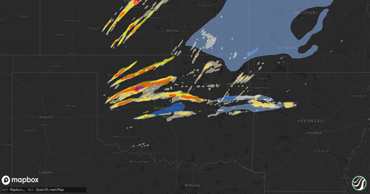
Hail Map on May 6, 2024
Get this storm
May 6 map
$229
one time, instant access
Download today. No call, no setup
Keep the $229
Bought the map and want the full workflow? Apply the entire $229 to a subscription within 7 days. None of it is wasted.
Every map, not just this one
This buys you this map. Subscription and you get every map we run, in the markets you choose from a few cities to whole states to nationwide. Plus real-time alerts the moment a storm fires.
Contact data
Name, contact info, occupancy, even credit band for addresses in the footprint. You go from where it hit to who to call.
Become the source they trust
Unlimited branding weather history reports on demand. You already have the documented answer ready for the property owner, and you are the one who showed up with it.
Property data and RoofTrace estimates
Pull up any address you have got, its value and the exact code rules for that jurisdiction, straight from One Click Code. Then RoofTrace estimates the squares, pitch, and roof value, priced the way you price.
States Impacted by Hail Map on May 6, 2024
Storm reports
Oklahoma
| Date | Description |
|---|---|
| 05/06/20246:59 PM CDT | Spotternetwork report. Trees uprooted... Power lines snapped... Single home structure damage. Time is radar estimate. Possible tornado damage. |
| 05/06/20246:57 PM CDT | Report from mping. |
| 05/06/20246:55 PM CDT | Power poles down and tree damage at hwy 51 and south hwy 132. |
| 05/06/20246:45 PM CDT | A local report indicates 1.75 inch wind near Okeene |
| 05/06/20246:43 PM CDT | A local report indicates a tornado near 4 SE Okeene |
| 05/06/20246:37 PM CDT | Report from mping. |
| 05/06/20246:35 PM CDT | Photo relayed through nwschat. |
| 05/06/20246:15 PM CDT | A local report indicates 65 MPH wind near 3 N Putnam |
| 05/06/20246:10 PM CDT | Twitter photo with noted melting; time estimated based on radar. |
| 05/06/20246:09 PM CDT | Report relayed by nws employee. |
| 05/06/20245:55 PM CDT | A local report indicates 1.75 inch wind near Oakwood |
| 05/06/20245:33 PM CDT | Time estimated based on radar. |
| 05/06/20245:15 PM CDT | A local report indicates 61 MPH wind near 7 SSW Alva |
| 05/06/20245:09 PM CDT | A local report indicates 82 MPH wind near 9 N Chester |
| 05/06/20244:20 PM CDT | A local report indicates 1.75 inch wind near 4 SE Woodward |
| 05/06/20244:18 PM CDT | Report from mping. |
| 05/06/20244:10 PM CDT | Corrects previous hail report from 4 se woodward. Time estimated based on radar. |
| 05/06/202411:42 AM CDT | Corrects previous tstm wnd gst report from 2 se valley brook. Time estimated from radar. Report from 89th and bryant. |
| 05/06/202411:42 AM CDT | Corrects previous tstm wnd gst report from 2 se valley brook. Corrects previous tstm wnd gst report from 2 se valley brook. Time estimated from radar. Report from 89th |
| 05/06/202411:38 AM CDT | Fence damage. Facebook report with picture. Time estimated from radar. |
| 05/06/202410:38 AM CDT | Sw 119th between s. Western and s. Penn. Damaged power poles. Facebook report with picture. Time est. From radar. |
| 05/06/20241:29 AM CDT | 60 mph gust at davis field |
| 05/06/20241:20 AM CDT | Power outages and trees broken. Time estimated via radar. |
| 05/06/20241:17 AM CDT | Estimated winds. Trees blocking roads near davis airport. |
| 05/06/202412:50 AM CDT | Several reports of tree damage... Plus damage to carports and a couple of barns in muskogee county. Time of report based on radar data. |
| 05/06/202412:43 AM CDT | Nwschat report. |
| 05/06/202412:34 AM CDT | 50 to 60 mph winds reported near okmulgee by broadcast media storm chaser. |
| 05/06/202412:12 AM CDT | Downed tree limbs. Fb report. Time est. From radar. |
| 05/05/202411:56 PM CDT | A local report indicates 65 MPH wind near 8 SE Oklahoma City |
| 05/05/202411:56 PM CDT | Down trees. Buck rd. Next to twin lakes. Fb report. Time estimated from radar. |
| 05/05/202411:55 PM CDT | 3-inch tree limbs broken; power poles broken. |
| 05/05/202411:55 PM CDT | A local report indicates 66 MPH wind near Tinker Air Force Base |
| 05/05/202411:55 PM CDT | 3-inch tre |
| 05/05/202411:51 PM CDT | Nwschat report. |
| 05/05/202411:50 PM CDT | Powerlines and tree limbs blown down. Radar estimated time. |
| 05/05/202411:48 PM CDT | Snapped tree trunk. Midwest city near reno. Fb report. Time estimated from radar. |
| 05/05/202411:47 PM CDT | Downed tree. Facebook report with picture. Time est. From radar. |
| 05/05/202411:46 PM CDT | South side of wood fence gone. North rock creek. Facebook with picture. Time estimated from radar. |
| 05/05/202411:45 PM CDT | Powerline down. Spotter network report. Radar estimated time. |
| 05/05/202411:44 PM CDT | Corrects previous tstm wnd dmg report from 3 wnw moore. Sw 119th between s. Western and s. Penn. Damaged power poles. Facebook report with picture. Time est. From radar |
| 05/05/202411:44 PM CDT | Downed tree. Facebook report with picture. Time based on radar. |
| 05/05/202411:43 PM CDT | Power poles down on bryant between se 19th and se 4th street. Fb report. Time estimated on radar. |
| 05/05/202411:42 PM CDT | A local report indicates 1.00 inch wind near 2 SE Valley Brook |
| 05/05/202411:42 PM CDT | Overturned semi-trailer. Time estimated from radar. Facebook report with picture. |
| 05/05/202411:42 PM CDT | Damage to webster middle school soccer goals. Facebook report with picture. Time estimated from radar. |
| 05/05/202411:42 PM CDT | Corrects previous tstm wnd gst report from 2 se valley brook. Corrects previous tstm wnd gst report from 2 se valley brook. Corrects previous tstm wnd gst report from 2 |
| 05/05/202411:39 PM CDT | Snapped tree. |
| 05/05/202411:38 PM CDT | A local report indicates 69 MPH wind near 6 SW Oklahoma City |
| 05/05/202411:35 PM CDT | Report from mping: golf ball |
| 05/05/202411:30 PM CDT | Report from mping: 3-inch tree limbs broken; power poles broken. |
| 05/05/202411:30 PM CDT | A local report indicates 71 MPH wind near 2 SSW Minco |
| 05/05/202411:30 PM CDT | Damaged power poles |
| 05/05/202411:30 PM CDT | Powerlines and tree branches blown down. Radar estimated time. |
| 05/05/202411:27 PM CDT | Report from mping. |
| 05/05/202411:25 PM CDT | A local report indicates 64 MPH wind near 2 SSW Minco |
| 05/05/202411:25 PM CDT | Report from mping. |
| 05/05/202411:20 PM CDT | A local report indicates 59 MPH wind near 2 SSW Minco |
| 05/05/202411:02 PM CDT | Report from mping. |
| 05/05/202411:00 PM CDT | Damage to welch schools... Including to the roof of the gymnasium. |
| 05/05/202410:50 PM CDT | Vinita mesonet. |
| 05/05/202410:45 PM CDT | A local report indicates 59 MPH wind near 4 NNW Fort Cobb |
| 05/05/202410:39 PM CDT | Report from mping. |
| 05/05/202410:26 PM CDT | Damage to homes and power lines down approximately 1 mile south and 2 miles east of south coffeyville. |
| 05/05/202410:24 PM CDT | A local report indicates 1.75 inch wind near 7 SSE Guthrie |
| 05/05/202410:22 PM CDT | Report from mping. |
| 05/05/202410:21 PM CDT | Report from mping. |
| 05/05/202410:20 PM CDT | A local report indicates 59 MPH wind near Talala |
| 05/05/202410:04 PM CDT | A local report indicates 59 MPH wind near 3 NW Stillwater |
| 05/05/202410:00 PM CDT | Damage near the hampton inn at 75 and tuxedo blvd in bartlesville likely due to a tornado. |
| 05/05/20249:40 PM CDT | Corrects previous rain report from 4 sse marshall. Its wind... Not rain. |
| 05/05/20249:40 PM CDT | Multiple reports of structural damage and multiple chaser photos and videos of a tornado in and near barnsdall. |
| 05/05/20249:24 PM CDT | Hominy pd report relayed via emergency management. |
| 05/05/20249:13 PM CDT | Report from mping; time is estimated based on radar. |
| 05/05/20249:13 PM CDT | Re |
| 05/05/20249:04 PM CDT | 65 to 75 mph winds estimated by a broadcast media storm chaser on highway 60 east of burbank. |
| 05/05/20248:12 PM CDT | Snapped power lines reported via spotter network; time estimated based on radar. |
| 05/05/20247:53 PM CDT | Relayed via nwschat; at the intersection of state hwy 74 and flynn rd. |
| 05/05/20247:45 PM CDT | Uprooted tree. Facebook report with picture. |
| 05/05/20247:27 PM CDT | Barn destroyed. 8 miles east and 5 miles north of hennessey. Facebook report. |
| 05/05/20247:27 PM CDT | Initial spotternetwork report of a rope tornado... Also confirmed by broadcast media. |
| 05/05/20247:15 PM CDT | Report from mping. |
Tennessee
| Date | Description |
|---|---|
| 05/06/20246:35 PM CDT | Trees down. Flag pole snapped. Minor structural damage to home. |
| 05/06/20245:30 PM CDT | Large trees down on hickory valley road just south of panther drive in sparta. |
| 05/06/20245:25 PM CDT | Tspotter photo of quarter size hail on honeysuckle ln southwest of sparta. |
| 05/06/20245:13 PM CDT | Facebook photo showed quarter to half dollar size hail fell near beech grove. Location estimated based on radar. |
| 05/06/20244:55 PM CDT | Ping pong sized hail reported in gatlinburg. Relayed through facebook. Time estimated. |
| 05/06/20244:54 PM CDT | A local report indicates 1.00 inch wind near 5 E Smithville |
| 05/06/20244:48 PM CDT | Social media picture. |
| 05/06/20244:48 PM CDT | A local report indicates 1.50 inch wind near 9 NNW Bell Buckle |
| 05/06/20244:42 PM CDT | From facebook. |
| 05/06/20244:25 PM CDT | Facebook photo showed two trees snapped on mount juliet side of percy priest lake. Location estimated based on radar. |
| 05/06/20244:24 PM CDT | Off-duty employee and emergency manager report tornado. Video from social media also confirms. |
| 05/06/20244:23 PM CDT | An ef1 tornado touched down east of highway 70 in northwest smithville then moved east paralleling allen ferry rd. Numerous trees were broken... Snapped and uprooted al |
| 05/06/20244:14 PM CDT | Mping report of quarter sized hail. |
| 05/06/20244:09 PM CDT | Social media report. |
| 05/06/20244:04 PM CDT | Social media picture. |
| 05/06/20244:02 PM CDT | Report from mping: half dollar |
| 05/06/20244:01 PM CDT | A local report indicates 1.50 inch wind near 6 WNW College Grove |
| 05/06/20243:56 PM CDT | Mping report of half dollar hail. |
| 05/06/20243:18 PM CDT | Social media report. |
| 05/06/20243:03 PM CDT | Social media report. |
| 05/06/20242:57 PM CDT | From social media. |
| 05/06/20242:55 PM CDT | A local report indicates 1.00 inch wind near Lebanon |
| 05/06/20242:55 PM CDT | A local report indicates 1.00 inch wind near Lebanon |
| 05/06/20242:55 PM CDT | A brief ef0 tornado touched down along big springs road north of old rome pike around 7 miles northeast of lebanon. Several videos of the tornado were taken from nearby |
| 05/06/20242:52 PM CDT | A local report indicates 1.00 inch wind near 1 SSE Lebanon |
| 05/06/20242:50 PM CDT | Facebook report of several trees blown down on south cumberland street in lebanon. |
| 05/06/20242:45 PM CDT | Tspotter photo of half dollar size hail in warren county. Estimated location based on radar. |
| 05/06/20241:06 PM CDT | Tspotter photo of a large tree branch and power line down on mount vernon rd at old highway 31e. |
| 05/06/20241:05 PM CDT | Tspotter photo of a tree down on rogana rd at rock springs rd. |
| 05/05/20247:40 PM CDT | Numerous reports of trees down across blount county. Strongest winds affected alcoa and maryville. Time estimated off radar. |
| 05/05/20247:39 PM CDT | Report from mping: quarter |
| 05/05/20247:28 PM CDT | Trees down on b street in lenoir city... As well as multiple locations in loudon county. |
Iowa
| Date | Description |
|---|---|
| 05/06/20245:17 AM CDT | A local report indicates 1.00 inch wind near 2 WSW Riverdale |
| 05/06/20245:03 AM CDT | Many tree branches down in grand mound. Time estimated from radar. |
| 05/06/20245:03 AM CDT | Damage to the roof of a building. Owner says the roof paneling is rated to 90 mph. |
| 05/06/20244:56 AM CDT | Large tree down along with small branches through town. Time based on radar. |
| 05/06/20244:56 AM CDT | Numerous branches down near vanderveer park. Some branches several inches thick. |
| 05/06/20244:55 AM CDT | Large tree limbs down on a house. Public report via social media. Time estimated by radar. |
| 05/06/20244:35 AM CDT | A local report indicates 62 MPH wind near 2 S Sweetland Center |
| 05/06/20244:13 AM CDT | Trees down in west branch. Time based on radar. |
| 05/06/20244:08 AM CDT | 2 to 4 inch diameter branches down. |
| 05/06/20244:01 AM CDT | Branches down at this location. Report from social media. |
| 05/06/20243:45 AM CDT | Tree down. Report from social media. |
| 05/06/20243:35 AM CDT | Awos station kmpz mount pleasant arpt. |
| 05/06/20243:35 AM CDT | Trees down between mt union and mt pleasant. |
| 05/06/20243:30 AM CDT | Numerous reports of branches down on south side of town along with a couple of trees. Time based on radar. |
| 05/06/20243:05 AM CDT | Van horne rwis at us 30 and ia218. |
| 05/06/20242:59 AM CDT | Siding ripped from house and tree branches down. Report from social media... Time estimated by radar. |
| 05/06/20242:45 AM CDT | Branches down. Time based on radar. |
| 05/06/20242:29 AM CDT | Asos station kotm ottumwa regional airport. |
| 05/06/20242:18 AM CDT | Asos station kmiw marshalltown airport. |
| 05/06/20241:34 AM CDT | Emergency manager reported a tree fallen on a home. Power lines also down in the area. Time estimated from radar. |
| 05/06/20241:10 AM CDT | Trained spotter reported a tree and large branches down at the intersection of s23 and hwy 92. Time estimated from radar. |
| 05/06/202412:47 AM CDT | Emergency manager reported damage south of osceola... Including a snapped tree 2 feet in diameter and the western portion of the roof ripped off of a home. Time estimat |
| 05/05/202411:15 PM CDT | Large tree down along 3rd st. From who tv. Time estimated by radar. |
| 05/05/202410:04 PM CDT | Personal weather station. |
| 05/05/20249:59 PM CDT | Personal weather station measured gust. |
| 05/05/20249:31 PM CDT | From a personal weather station. |
| 05/05/20249:30 PM CDT | Empty grain bin blown off its foundation. Time estimated from radar. |
| 05/05/20249:21 PM CDT | From a personal weather station. |
| 05/05/20249:19 PM CDT | From a personal weather station. |
| 05/05/20249:18 PM CDT | Tornado debris signature confirmed on radar. |
| 05/05/20249:17 PM CDT | Power poles snapped. Likely from a tornado. |
| 05/05/20249:16 PM CDT | Damage to a residence... Likely from a tornado. |
| 05/05/20249:16 PM CDT | Tornado debris signature confirmed on radar. |
| 05/05/20249:15 PM CDT | Em reports that part of the roof of the new car wash in sutherland was ripped off... And several homes had tree branches land on them. |
| 05/05/20249:14 PM CDT | Power lines across the road. Possible damage to a residence likely from a tornado. |
| 05/05/20249:13 PM CDT | This ef1 tornado touched down at 9:10pm 2 miles southeast of minden causing ef1 damage to a transmission line. It then traveled northeast and damaged outbuildings and b |
| 05/05/20249:08 PM CDT | High tension power lines blown down. |
| 05/05/20249:08 PM CDT | High tension powerlines blown down. |
| 05/05/20249:08 PM CDT | Large tree snapped. Several additional trees sheared off the top. |
| 05/05/20249:07 PM CDT | Brief ef-1 tornado damage was observed 4 miles west/northwest of macedonia where two large trees were snapped and then lifted about a mile northeast of where one home s |
| 05/05/20249:05 PM CDT | From a personal weather station. |
| 05/05/20248:59 PM CDT | From a personal weather station. |
| 05/05/20248:58 PM CDT | From a personal weather station. |
| 05/05/20248:52 PM CDT | Damage to a home and multiple outbuildings. |
| 05/05/20248:48 PM CDT | An ef-1 tornado developed and snapped trees at a home on lucas road... Moving quickly to the northeast where it cut a 30 yard wide swath of snapped trees and branches. |
| 05/05/20248:09 PM CDT | Farm outbuildings had extreme roof damage. Time of damage estimated from radar. |
| 05/05/20247:25 PM CDT | Mesonet station rsyi4 sibley. |
Georgia
| Date | Description |
|---|---|
| 05/06/20242:42 PM CDT | Ping pong sized hail at hwy29 and diamond hill neese rd. |
| 05/06/20242:38 PM CDT | Tree down on crabapple hollow rd near nowhere rd. |
| 05/06/20242:38 PM CDT | Tree down on crabapple hollow rd near nowhere rd. Farm road 26. |
| 05/06/20242:26 PM CDT | Spotter reported dime to quarter size hail near the intersection of s. Old belair road and millhaven road. Hail continued for 5 minutes. |
Minnesota
| Date | Description |
|---|---|
| 05/05/20249:16 PM CDT | Report of a downed power line in ivanhoe... Mn. Also recieved reports of treest. Time estimated from radar. |
| 05/05/20249:16 PM CDT | Report of a downed power line in ivanhoe... Mn. Also recieved reports of trees down within the city limits. |
| 05/05/20248:54 PM CDT | Report of a few trees down in verdi... Along with numerous branches as well. Recieved report via facebook. |
| 05/05/20248:54 PM CDT | Multiple large tree branches down. Report/picture via social media with time estimated using radar. |
North Carolina
| Date | Description |
|---|---|
| 05/06/20242:07 PM CDT | Primarily pea to nickel sized hail fell... With pictures and video provided on social media. Largest hailstones were a quarter inch in diameter. |
| 05/05/202410:07 PM CDT | Tree and powerlines downed by thunderstorm winds near the intersection of springs road and mount view drive. |
| 05/05/20249:58 PM CDT | Tree limbs downed by thunderstorm winds... Blocking one lane of the road near the intersection of siloam road and little mountain church road. |
| 05/05/20249:29 PM CDT | Tree downed by thunderstorm winds at the impound lot near the intersection of johnson ridge road and east main street. |
| 05/05/20249:24 PM CDT | Tree down near intersection of johnson ridge road and east main street. |
| 05/05/20249:21 PM CDT | Multiple trees down on road way. |
| 05/05/20249:07 PM CDT | Large tree blocking roadway. |
| 05/05/20249:07 PM CDT | Large tree blockin |
| 05/05/20249:00 PM CDT | Tree on power lines. |
Colorado
| Date | Description |
|---|---|
| 05/06/20246:13 PM CDT | Small tree limbs broken. |
Kansas
| Date | Description |
|---|---|
| 05/06/20246:57 PM CDT | Also 3/4 inch hail. |
| 05/06/20246:48 PM CDT | Also estimating 50 mph winds. |
| 05/06/20246:44 PM CDT | Also estimating 50 mph winds. |
| 05/06/20246:22 PM CDT | Power pole snapped. Time estimated via radar. |
| 05/06/20246:13 PM CDT | A local report indicates 1.50 inch wind near 5 SE Garfield |
| 05/06/20246:07 PM CDT | A local report indicates 1.00 inch wind near Nickerson |
| 05/06/20245:45 PM CDT | Kcnk concordia blosser field. |
| 05/06/20245:06 PM CDT | A local report indicates 2.50 inch wind near Claflin |
| 05/06/20245:03 PM CDT | A local report indicates 1.75 inch wind near 2 E Pratt |
| 05/06/20245:02 PM CDT | A local report indicates 1.50 inch wind near 1 W Pratt |
| 05/06/20244:55 PM CDT | A local report indicates 1.00 inch wind near 2 S Stafford |
| 05/06/20244:54 PM CDT | A local report indicates 1.00 inch wind near Claflin |
| 05/06/20244:51 PM CDT | Corrects time on previous hail report from claflin. |
| 05/06/20244:51 PM CDT | Report from mping: ping pong ball |
| 05/06/20244:50 PM CDT | Picture messaged to nws. |
| 05/06/20244:48 PM CDT | A local report indicates 1.75 inch wind near 4 N Iuka |
| 05/06/20244:41 PM CDT | A local report indicates 1.75 inch wind near 5 ENE Byers |
| 05/06/20244:40 PM CDT | Delayed report... Via image on social media |
| 05/06/20244:36 PM CDT | Just east of main hail core. One inch hail. |
| 05/06/20244:13 PM CDT | A local report indicates 1.00 inch wind near 1 ENE Wellsford |
| 05/06/20244:12 PM CDT | Nickel to quarter sized hail in paw |
| 05/06/20244:12 PM CDT | Nickel to quarter sized hail in pawnee rock. |
| 05/06/20243:51 PM CDT | Hail up to the size of quarters was reported between 351 and 356 pm. |
| 05/06/20243:39 PM CDT | Pea to golf ball size hail in smith center. |
| 05/06/20243:30 PM CDT | A local report indicates 1.75 inch wind near 1 WNW Cedar |
| 05/06/20243:29 PM CDT | A local report indicates 1.75 inch wind near 5 NW Coldwater |
| 05/06/20243:26 PM CDT | Corrects previous hail report from 5 se garfield. |
| 05/06/20243:25 PM CDT | Report from social media with pictures. |
| 05/06/20243:15 PM CDT | Social media photo of hail. |
| 05/06/20243:01 PM CDT | A local report indicates 1.25 inch wind near 8 N Kensington |
| 05/06/20242:48 PM CDT | Nickel to quarter size hail covering the ground. |
| 05/06/20242:46 PM CDT | Report received from social media. |
| 05/06/20242:40 PM CDT | Report via facebook. |
| 05/06/20242:38 PM CDT | Quarter... Ping pong and golf ball size hail reported in zurich. |
| 05/06/20242:29 PM CDT | Social media photo of hail. |
| 05/06/20242:28 PM CDT | Social media photo of hail. |
| 05/06/20242:05 PM CDT | Cocorahs observer commented about hail up to quarter size. Time estimated from radar. |
| 05/06/20242:01 PM CDT | A local report indicates 1.00 inch wind near Ogallah |
| 05/06/20241:53 PM CDT | Pea to quarter size hail covered the ground. Damage to vehicle. Time estimated from radar. |
| 05/06/20241:09 PM CDT | Report via mping. |
| 05/06/202411:26 AM CDT | A local report indicates 60 MPH wind near Hill City |
| 05/06/202410:33 AM CDT | Barn had the roof blown off. |
| 05/05/202411:25 PM CDT | Image via social media of trees down. Time estimated via radar. |
| 05/05/202411:24 PM CDT | Heavy rain... Wind approximately 50-60 mph in pittsburg... Crawford county. |
| 05/05/202411:21 PM CDT | Pictures of roof damage... Garage door blown in... Farm equipment tipped over. Time based on radar. Delayed report. |
| 05/05/202411:21 PM CDT | Image via social media of some roofing material blown off of a residence. Time estimated via radar. Location approximated. |
| 05/05/202411:10 PM CDT | Significant damage to a barn near sw 40th road and highway 166. |
| 05/05/202411:00 PM CDT | Downed wires and power outages near 71st street. Time estimated from radar. |
| 05/05/202411:00 PM CDT | Tree fell on a house with injuries reported by emergency management. |
| 05/05/202410:55 PM CDT | Downed tree and wires near greeley avenue. Time estimated from radar. |
| 05/05/202410:49 PM CDT | Downed wires and power outages near 7th street. Time estimated from radar. |
| 05/05/202410:49 PM CDT | Multiple reports of downed tree limbs and wires in the muncie area. Time estimated from radar. |
| 05/05/202410:46 PM CDT | Several reports of wires down and power outages in the area near cedar street. Time estimated from radar. |
| 05/05/202410:44 PM CDT | A local report indicates 60 MPH wind near Edna |
| 05/05/202410:39 PM CDT | Report from mping: 3-inch tree limbs broken; power poles broken. Time corrected from radar. |
| 05/05/202410:39 PM CDT | Downed wires and power outages near wolcott road. Time estimated from radar. |
| 05/05/202410:39 PM CDT | Downed wires and power outages near 215th street. Time estimated from radar. |
| 05/05/202410:33 PM CDT | Corrects previous tstm wnd dmg report from 4 s angola. Barn had the roof blown off. |
| 05/05/202410:33 PM CDT | Downed tree and wires near hollingsworth road. Time estimated from radar. |
| 05/05/202410:28 PM CDT | Power line down. |
| 05/05/202410:26 PM CDT | Downed wires and power outages near dwyer road. Time estimated from radar. |
| 05/05/202410:12 PM CDT | Delayed report |
| 05/05/202410:01 PM CDT | Personal weather station. |
| 05/05/20249:55 PM CDT | Corrects previous tstm wnd gst report from 3 s elk city. |
| 05/05/20249:54 PM CDT | A local report indicates 1.50 inch wind near 1 S Baileyville |
| 05/05/20249:29 PM CDT | A local report indicates 60 MPH wind near 3 W Le Roy |
| 05/05/20249:26 PM CDT | A local report indicates 70 MPH wind near Elk City |
| 05/05/20249:22 PM CDT | A local report indicates 70 MPH wind near Fall River |
| 05/05/20249:10 PM CDT | A local report indicates 1.00 inch wind near 2 W Olsburg |
| 05/05/20248:56 PM CDT | A local report indicates 68 MPH wind near Severy |
| 05/05/20248:55 PM CDT | Possible tornado crossed the state line near hewins. Report passed on from media. |
| 05/05/20248:52 PM CDT | A local report indicates 2.75 inch wind near 4 E Riley |
| 05/05/20248:50 PM CDT | Social media photo. Radar estimated time. |
| 05/05/20248:29 PM CDT | A local report indicates 4.00 inch wind near 7 N Moonlight |
| 05/05/20248:28 PM CDT | A local report indicates 3.00 inch wind near 7 NE Moonlight |
| 05/05/20248:26 PM CDT | A local report indicates 4.00 inch wind near 7 NNE Moonlight |
| 05/05/20248:23 PM CDT | Power line down on roadway along us-160. |
| 05/05/20248:14 PM CDT | Estimated from social media photo. |
| 05/05/20248:00 PM CDT | A local report indicates 1.00 inch wind near 1 N Abilene |
| 05/05/20247:48 PM CDT | Mhk atc reported +fc b48. No direction or distance given. Estimated by radar. No end time. |
| 05/05/20247:34 PM CDT | Kmhk manhattan municipal airport. |
| 05/05/20247:21 PM CDT | Public posted video on social media. Also small hail. |
| 05/05/20247:20 PM CDT | Also 3/4 inch hail. |
| 05/05/20247:20 PM CDT | Also 3/4 inch hail. |
| 05/05/20247:15 PM CDT | A local report indicates 1.00 inch wind near 6 NE Chapman |
| 05/05/20247:12 PM CDT | A local report indicates 1.00 inch wind near 7 NNE Chapman |
| 05/05/20247:04 PM CDT | A local report indicates 1.00 inch wind near Enterprise |
| 05/05/20247:01 PM CDT | A local report indicates 1.00 inch wind near 8 SSW Enterprise |
Florida
| Date | Description |
|---|---|
| 05/06/20243:40 PM CDT | Tree down near old bainbridge and capital circle nw in tallahassee... Fl. |
| 05/06/20243:35 PM CDT | Half dollar sized hail reported on social media. |
| 05/06/20243:30 PM CDT | Half dollar sized hail reported via social media. |
South Dakota
| Date | Description |
|---|---|
| 05/06/20243:18 PM CDT | A local report indicates 68 MPH wind near 15 SSE Mission |
| 05/06/20242:20 PM CDT | Wind still gusting over 60 mph. |
| 05/06/20242:07 PM CDT | Second touchdown of the tornado west of mud butte. |
| 05/06/20241:49 PM CDT | Tornado on the ground for about 5 minutes. Started south of highway 212 and appeared to cross highway 212. Tornado lifted on the north side of highway 212. |
| 05/05/20248:17 PM CDT | Multiple tree branches |
| 05/05/20248:15 PM CDT | Hoop house blown over and multiple large tree branches down. Report via social media with time estimated using radar. |
| 05/05/20248:09 PM CDT | Report of a tree down... With a couple sizeable branches down as well. Recieved report via facebook. |
| 05/05/20247:31 PM CDT | Very strong wind gusts measured by mobile mesonet... Along with heavy rain. |
Missouri
| Date | Description |
|---|---|
| 05/06/202411:40 AM CDT | Via social media pictures of damage to large tree and hvac unit toppled. |
| 05/06/20245:39 AM CDT | Corrects previous tstm wnd dmg report from 2 wnw bourbon. Corrects previous tstm wnd dmg report from 2 wnw bourbon. Delayed report. Tree down over roadway at hwy c near |
| 05/06/20245:35 AM CDT | Corrects previous tstm wnd dmg report from 2 e cherryville. Delayed report. Tree down over roadway along hwy 49 near dan halbert road. Time estimated from radar. |
| 05/06/20245:27 AM CDT | Corrects previous tstm wnd dmg report from 1 wnw steelville. Delayed report. Tree down over roadway near roadside park. Time estimated from radar. |
| 05/06/20245:27 AM CDT | Delayed report. Tree down over roadway at the 1200 block of hwy 19. Time estimated from radar. |
| 05/06/20244:56 AM CDT | Large section of tree blown over onto a fence knocking the fence down. Via facebook with picture. |
| 05/06/20244:40 AM CDT | Delayed report. 6-8 inch tree limbs snapped off tree... A few punctured holes in a house roof. No other structural damage. |
| 05/06/20244:23 AM CDT | Several large tree limbs blown down. Via facebook with picture. |
| 05/06/20244:21 AM CDT | A brief ef-0 tornado with maximum wind gusts of 76mph touched down northwest of defiance west of the weldon spring conservation area and tracked east-northeast. It snap |
| 05/06/20244:19 AM CDT | Large tree blown over on top of an unoccupied suv. Via facebook with picture. |
| 05/06/20244:19 AM CDT | Tree down on highway 47 between bonne terre and terre du lac. Time estimated based on radar. |
| 05/06/20243:50 AM CDT | Large tree uprooted. Roof damage to a home... Including damage to eaves and lifted shingles in one corner of the roof. |
| 05/06/20243:46 AM CDT | Pictures sent in of considerable damage to business near sullivan that occurred with a tds. |
| 05/06/20243:46 AM CDT | Tree down on highway 8 near berryman. Time estimated from radar. |
| 05/06/20243:45 AM CDT | A brief ef-1 tornado with maximum wind gusts of 100mph touched down at 3:45am at sullivan high school and tracked northeast. Among the worst damage... The tornado cause |
| 05/06/20243:44 AM CDT | A brief ef-0 tornado with maximum wind gusts of 80mph touched down southeast of bourbon... Mo causing tree damage before lifting one minute later. |
| 05/06/20243:39 AM CDT | Corrects previous tstm wnd dmg report from 2 wnw bourbon. Corrects previous tstm wnd dmg report from 2 wnw bourbon. Corrects previous tstm wnd dmg report from 2 wnw bou |
| 05/06/20243:35 AM CDT | Corrects previous tstm wnd dmg report from 2 e cherryville. Corrects previous tstm wnd dmg report from 2 e cherryville. Delayed report. Tree down over roadway along hwy |
| 05/06/20243:27 AM CDT | Corrects previous tstm wnd dmg report from 1 s cuba. Delayed report. Tree down over roadway at the 1200 block of hwy 19. Time estimated from radar. |
| 05/06/20243:27 AM CDT | Large pine tree uprooted. Via facebook with picture. |
| 05/06/20243:27 AM CDT | Multiple large trees down on old springfield road west of cuba. |
| 05/06/20243:24 AM CDT | Delayed report. Multiple trees snapped along the upper portion of the trunk. Time estimated from radar. |
| 05/06/20243:23 AM CDT | Metal sections of garage roof removed and blown into field. Time estimated based on radar. Report from social media. |
| 05/06/20243:03 AM CDT | Delayed report. Time based on radar. Four large trees toppled or split. |
| 05/06/20243:02 AM CDT | Tree down on road se of kahoka. Time based on radar. |
| 05/06/20242:41 AM CDT | Garage destroyed and large tree branch fell onto pickup truck. Power pole snapped off. Via facebook with pictures. |
| 05/06/20242:39 AM CDT | Large tree limbs down. |
| 05/06/20242:18 AM CDT | Carport blown out along route a... Exact location unknown and estimated. |
| 05/06/20242:17 AM CDT | A few windows blown out of a second story of a house. |
| 05/06/20242:16 AM CDT | 4-6 inch limbs snapped. |
| 05/06/20242:16 AM CDT | Multiple trees down on county road 401 south of ava. Section of barn damaged. |
| 05/06/20242:15 AM CDT | Numerous tree limbs blown down as well as several trees. One light post partially blown over. Via facebook with pictures. |
| 05/06/20242:09 AM CDT | Numerous limbs down across town... Power pole snapped in madison. |
| 05/06/20242:05 AM CDT | Trees down and minor barn damage west of goodhope off highway t. |
| 05/06/20241:57 AM CDT | Downed wires and power outages near end place. Time estimated from radar. |
| 05/06/20241:57 AM CDT | Downed wires and power outages near county road 2735. Time estimated from radar. |
| 05/06/20241:54 AM CDT | Report from mping: 3-inch tree limbs broken; power poles broken. Time corrected from radar. |
| 05/06/20241:46 AM CDT | Downed trees and wires near route b. Time estimated from radar. |
| 05/06/20241:46 AM CDT | Tree down on power lines in higbee. |
| 05/06/20241:40 AM CDT | A local report indicates 64 MPH wind near 1 S Willard |
| 05/06/20241:35 AM CDT | Downed tree and wires near clarks fork road. Time estimated from radar. |
| 05/06/20241:30 AM CDT | Mesonet station gw3917 versailles. |
| 05/06/20241:24 AM CDT | Report from mping... 1-inch tree limbs broken... Shingles blown off. Time based on radar. |
| 05/06/20241:24 AM CDT | Report from mping... 1-inch tree limbs broken... Shingles blown off. Time based on radar. |
| 05/06/20241:18 AM CDT | Report from mping... 1-inch tree limbs broken... Shingles blown off. Time based on radar. |
| 05/06/20241:17 AM CDT | Downed wires and power outages near wheatley road. Time estimated from radar. |
| 05/06/20241:13 AM CDT | Report from mping... 1-inch tree limbs broken... Shingles blown off. Time based on radar. |
| 05/06/20241:12 AM CDT | Report from mping... 1-inch tree limbs broken... Shingles blown off. |
| 05/06/20241:10 AM CDT | Report from mping... 1-inch tree limbs broken... Shingles blown off. |
| 05/06/20241:05 AM CDT | Corrects previous tstm wnd dmg report from 2 n laquey. Delayed report. Time based on radar. Multiple trees down. |
| 05/06/20241:04 AM CDT | Multiple reports of wires down and power outages near route 41... 215th road... And 220th road. Time estimated from radar. |
| 05/06/20241:04 AM CDT | Downed wires and power outages near route 240. Time estimated from radar. |
| 05/06/202412:58 AM CDT | 16 to 18 inch trees snapped along with many branches down. Time based on radar. |
| 05/06/202412:55 AM CDT | Two large oak trees reported down along with a portable building blown over. |
| 05/06/202412:54 AM CDT | Report from mping 1-inch tree limbs broken... Shingles blown off. Time based on radar. |
| 05/06/202412:53 AM CDT | Downed power lines and power outages near route h. Time estimated from radar. |
| 05/06/202412:51 AM CDT | Downed wires and power outages near huron street. Time estimated from radar. |
| 05/06/202412:50 AM CDT | Image via social media of a tree uprooted and fallen on a truck. |
| 05/06/202412:45 AM CDT | Social media pictures/account. Roof that was already blown off from 4/1/24 tornadoes moved 15 to 20 feet and took out the fence line. |
| 05/06/202412:45 AM CDT | Delayed report. Time based on radar. Roof and side of house damaged. Tree branches broken off of tree. |
| 05/06/202412:41 AM CDT | Springfield airport measured 60 mph gust. |
| 05/06/202412:41 AM CDT | Downed wires and power outages near route 52. Time estimated from radar. |
| 05/06/202412:40 AM CDT | Corrects previous tstm wnd gst report from 1 s willard. Corrects previous tstm wnd gst report from 1 s willard. |
| 05/06/202412:37 AM CDT | Image received via social media of a large tree trunk snapped at the base. |
| 05/06/202412:35 AM CDT | Trees down near intersection of highway h and farm road 26. |
| 05/06/202412:34 AM CDT | Power lines downed on east side of trenton. Measured wind gust of 57 mph. |
| 05/06/202412:34 AM CDT | Surface gauge measured gust. Time estimated from radar. |
| 05/06/202412:33 AM CDT | *** 1 inj *** nws survey found an ef-0 tornado touched down just northwest of willard and tracked to the northeast before lifting northwest of fair grove. Maximum winds |
| 05/06/202412:31 AM CDT | Downed wires and power outages near miller street. Time estimated from radar. |
| 05/06/202412:30 AM CDT | Tree across humansville rd in osceola. About 10-12 inches across at base. Time based on radar. |
| 05/06/202412:30 AM CDT | Report from mping... 1-inch tree limbs broken... Shingles blown off. Time based on radar. |
| 05/06/202412:28 AM CDT | Pictures sent in of multiple trees uprooted and snapped with one outbuilding roof collapsed. Time estimated via radar. |
| 05/06/202412:28 AM CDT | Downed wires and power outages near kitty street. Time estimated from radar. |
| 05/06/202412:22 AM CDT | Multiple reports of wires down and power outages in harrison county. Time estimated from radar. |
| 05/06/202412:22 AM CDT | Delayed report via social media. Straight line wind damage resulted int damage to the side of a home and destroyed a barn. Time estimated from radar. |
| 05/06/202412:20 AM CDT | Delayed report. Time based on radar. Two power poles down. |
| 05/06/202412:20 AM CDT | Delayed report. Time based on radar. Large branches broken off tree. |
| 05/06/202412:20 AM CDT | Report from mping... 1-inch tree limbs broken... Shingles blown off. Time based on radar. |
| 05/06/202412:19 AM CDT | Downed power lines and power outages near smelser road. Time estimated from radar. |
| 05/06/202412:18 AM CDT | Large limb down on old hwy 13. Time based on radar. |
| 05/06/202412:15 AM CDT | Images sent via social media depicting multiple trees down... Knocking down power lines. Half of a barns roof was blown off with the roll-up door ripped out of the trac |
| 05/06/202412:12 AM CDT | Downed wires and power outages near route 7. Time estimated from radar. |
| 05/06/202412:02 AM CDT | Downed wires and power outages near daugherty road. Time estimated from radar. |
| 05/05/202411:59 PM CDT | Downed wires and power outages near cunningham street. Time estimated from radar. |
| 05/05/202411:56 PM CDT | Downed wires and power outages near valley drive. Time estimated from radar. |
| 05/05/202411:56 PM CDT | Downed wires and power outages near routes n and o. Time estimated from radar. |
| 05/05/202411:51 PM CDT | Report from mping... 3-inch tree limbs broken... Power poles broken. Time based on radar. |
| 05/05/202411:50 PM CDT | Hwy 96 and cr 80 house roof off and walls down. Time based on radar. |
| 05/05/202411:48 PM CDT | Report from mping... 3-inch tree limbs broken... Power poles broken. |
| 05/05/202411:43 PM CDT | Report from mping 3-inch tree limbs broken... Power poles broken. |
| 05/05/202411:43 PM CDT | Downed wires and power outages near old santa fe trail. Time estimated from radar. |
| 05/05/202411:40 PM CDT | Report from mping... Trees uprooted or snapped... Roof blown off. Time based on radar. |
| 05/05/202411:40 PM CDT | Nws storm survey found widespread 70-80 mph winds across carthage with numerous tree limbs down and trees uprooted. |
| 05/05/202411:39 PM CDT | Report from mping... Trees uprooted or snapped... Roof blown off. Time based on radar.... |
| 05/05/202411:39 PM CDT | Delayed report. Time based on radar. Huge tree down in backyard on glenwood place in carthage. |
| 05/05/202411:39 PM CDT | Widespread tree and powerline damage from brooklyn heights through the n side of carthage. |
| 05/05/202411:39 PM CDT | Report from mp mo 3810 9380 delayed report. Time based on radar. Two power poles down. |
| 05/05/202411:38 PM CDT | Nws storm survey found an ef-1 tornado path just west of carthage. Maximum winds were estimated at 95 mph. Trees were uprooted... Powerlines were snapped and several ro |
| 05/05/202411:36 PM CDT | Pictures via social media showing several large trees uprooted. Root base was approximately 10-15 feet across. Time estimated via radar. Location approximated around tr |
| 05/05/202411:36 PM CDT | Image via social media of a resident garage/shop collapsed. |
| 05/05/202411:36 PM CDT | Picture sent of a roof torn off. |
| 05/05/202411:33 PM CDT | Downed wires and power outages near 191st street. Time estimated from radar. |
| 05/05/202411:33 PM CDT | Semi truck flipped near interstate 70 between grain valley and blue springs. |
| 05/05/202411:33 PM CDT | Tree on a house in newton county off suburban terrace/grand falls blvd. Time based on radar. |
| 05/05/202411:32 PM CDT | Pictures via social media of fallen gas station signs and roof material blown off of lumber yard outbuildings along rangeline rd. Time estimated via radar. |
| 05/05/202411:31 PM CDT | Multiple reports of power outages and wires down near eagles parkway and willow drive. Time estimated from radar. |
| 05/05/202411:30 PM CDT | Delayed report. Large tree toppled over. |
| 05/05/202411:30 PM CDT | Delayed report. Via social media pictures of damage to large tree and hvac unit toppled. |
| 05/05/202411:30 PM CDT | Handful of power lines and trees down across the joplin area. Time based on radar. |
| 05/05/202411:30 PM CDT | Received images via email of several trees uprooted and branches snapped. |
| 05/05/202411:30 PM CDT | Pictures via social media of trees down and trunks snapped at the base. Partial roof damage on barn and small house nearby. |
| 05/05/202411:30 PM CDT | Report from mping 1-inch tree limbs broken... Shingles blown off. Time based on radar. |
| 05/05/202411:29 PM CDT | Nws storm survey found a ef-1 tornado with an intermittent damage path across the southeast and east side of joplin into duquesene. Maximum winds were estimated at 95 m |
| 05/05/202411:28 PM CDT | Newton county has storm damage off coyote/bluff dr north of i444 and a roof blown off a new construction on highway 43 and elm st. |
| 05/05/202411:22 PM CDT | Downed wires and power outages near liberty avenue. Time estimated from radar. |
| 05/05/202411:19 PM CDT | Private weather station reported a 60 mph gust at 1119 pm. |
| 05/05/202411:19 PM CDT | Downed wires and power outages near lindenwood lane. Time estimated from radar. |
| 05/05/202411:19 PM CDT | Downed wires and power outages near executive way. Time estimated from radar. |
| 05/05/202411:16 PM CDT | Report from mping: 3-inch tree limbs broken; power poles broken. Time corrected from radar. |
| 05/05/202411:15 PM CDT | Images via social media of several trees uprooted and large branches down. |
| 05/05/202411:13 PM CDT | Downed tree and wires near lawn avenue. Time estimated from radar. |
| 05/05/202411:13 PM CDT | Downed tree blocking a road in raymore. Time estimated from radar. |
| 05/05/202411:09 PM CDT | Downed wires and power outages near 223rd street. Time estimated from radar. |
| 05/05/202411:07 PM CDT | Mping report of trees uprooted near howard road. Time estimated from radar. |
| 05/05/202411:06 PM CDT | Downed wires and power outages near 40th streeing... Trees uprooted or snapped... Roof blown off. Time based on radar.... |
| 05/05/202411:06 PM CDT | Report from mping: 3-inch tree limbs broken; power poles broken. Time corrected from radar. |
| 05/05/202411:06 PM CDT | Downed tree and wires near westwood terrace. Time estimated from radar. |
| 05/05/202411:06 PM CDT | Downed wires and power outages near 40th street. Time estimated from radar. |
| 05/05/202411:05 PM CDT | Report from mping: 3-inch tree limbs broken; power poles broken. Time corrected from radar. |
| 05/05/202411:04 PM CDT | Report from mping: 3-inch tree limbs broken; power poles broken. Time corrected from radar. |
| 05/05/202411:02 PM CDT | Downed wires and power outages near route d. Time estimated from radar. |
| 05/05/202410:55 PM CDT | Downed wires and power outages near route ee. Time estimated from radar. |
| 05/05/202410:52 PM CDT | Downed wires and power outages near coker road. Time estimated from radar. |
| 05/05/202410:51 PM CDT | Downed wires and power outages near fontana avenue. Time based on dispatch report and confirmed from radar. |
| 05/05/202410:46 PM CDT | Downed wires and power outages near route n. Time estimated from radar. |
Illinois
| Date | Description |
|---|---|
| 05/06/20246:54 AM CDT | Powerline down across the intersection of banker and jaycee. |
| 05/06/20246:54 AM CDT | Trained spotter reported tree limb speared through roof of home with photos. |
| 05/06/20246:54 AM CDT | Multiple mobile homes with roof damage... Windows broken... Ac unit flipped... And large branches down. Photos provided by effingham fire deputy chief. |
| 05/06/20246:45 AM CDT | Time radar estimated. Tree limb down across roof of a home. Picture from social media near the crossroads of s main st and hamilton rd. |
| 05/06/20246:17 AM CDT | A measured 62 mph wind gust was reported by a trained spotter at route 9 and hoffman in mackinaw. |
| 05/06/20246:11 AM CDT | Corrects the time for the previous tstm wnd gst report from 1 sw mackinaw. A measured 62 mph wind gust was reported by a trained spotter at route 9 and hoffman in macki |
| 05/06/20245:55 AM CDT | Delayed report. Large tree limb at least 10 inches in diameter down from tree. Time estimated from radar. |
| 05/06/20245:51 AM CDT | Large tree across state route 93. Photo provided by a social media comment. |
| 05/06/20245:18 AM CDT | A local report indicates 60 MPH wind near Farmington |
| 05/06/20245:01 AM CDT | 5 inch diameter branch down at location. Time based on radar. |
| 05/06/20244:34 AM CDT | Machine shed damaged with debris spread across farm field. Also... Several large tree limbs snapped off. Via facebook with pictures. |
South Carolina
| Date | Description |
|---|---|
| 05/06/20245:45 PM CDT | Two trees down reported in walterboro. One at industrial road and jefferies highway... The other at otis road and sunny drive. Time estimated from radar. |
| 05/06/20245:44 PM CDT | Tree down blocking both lanes. Chainsaw needed to clear. |
| 05/06/20245:40 PM CDT | One tree blown down. Down within the city limits. |
| 05/06/20245:40 PM CDT | One tree blown down. |
| 05/06/20245:37 PM CDT | Tree down blocking one lane. |
| 05/06/20245:25 PM CDT | 2 trees were blown down on...buckhead drive and cedar street. |
| 05/06/20245:15 PM CDT | One tree blown down near enoree. |
| 05/06/20244:45 PM CDT | A local report indicates 1.25 inch wind near 7 WNW Williamston |
| 05/06/20244:45 PM CDT | A local report indicates 1.00 inch wind near 8 WNW Williamston |
| 05/06/20244:22 PM CDT | Power outage attributed to object contacting power lines. Time estimated from radar. |
| 05/06/20244:16 PM CDT | Power outage attributed to fallen trees/limbs. Time estimated from radar. |
| 05/06/20244:15 PM CDT | Shredded leaves noted. |
| 05/06/20244:05 PM CDT | Power outage attributed to fallen tree/limb. Time estimated from radar. |
| 05/06/20244:00 PM CDT | Sc highway patrol reported a tree down blocking the roadway on daniel ave near j paul rd. Time estimated by radar. |
| 05/06/20244:00 PM CDT | Relayed via emergency manager. |
| 05/06/20243:58 PM CDT | A local report indicates 1.50 inch wind near 3 NW Liberty |
| 05/06/20243:53 PM CDT | A local report indicates 1.00 inch wind near 6 W Six Mile |
| 05/06/20243:09 PM CDT | Hail near flat shoals rd and oconee court rd. |
| 05/05/20248:00 PM CDT | Schp reported a tree blown down on highway 247. |
| 05/05/20247:45 PM CDT | Schp reported a tree blown down on bowlan rd. |
Arkansas
| Date | Description |
|---|---|
| 05/06/20244:15 AM CDT | Tree reported down on a house. No injuries reported. |
| 05/06/20243:32 AM CDT | Tree limbs and powerlines down across the intersection of hwy 103/164. A metal building was also blown over at this location. |
| 05/06/20243:23 AM CDT | A local report indicates 1.00 inch wind near 3 NE Ozark |
| 05/06/20243:20 AM CDT | Power lines down on east main street. |
| 05/06/20243:15 AM CDT | House damaged on cataberry run. |
| 05/06/20243:15 AM CDT | Extensive tree damage or trees downed in the crosses area. Some trees downed onto a home. Possible tornado. |
| 05/06/20243:12 AM CDT | Multiple power outages in cass. |
| 05/06/20243:10 AM CDT | 15 inch diameter tree down on highway 215 just west of morgan mountain road |
| 05/06/20243:10 AM CDT | 15 inch daimeter tree down at white valley rd and wire rd. Time estimated from radar. |
| 05/06/20243:07 AM CDT | Multiple trees down on redding road. |
| 05/06/20243:00 AM CDT | Trees down in pleasant view area. White valley road and intersection of wire road. Time estimated via radar. |
| 05/06/20243:00 AM CDT | Tree down across highway 215. Time estimated via radar. |
| 05/06/20242:55 AM CDT | Multiple trees down west of fern on locke road. |
| 05/06/20242:47 AM CDT | Trees down in arkoma. |
| 05/06/20242:46 AM CDT | Power outages in dean springs. |
| 05/06/20242:46 AM CDT | A local report indicates 70 MPH wind near Van Buren |
| 05/06/20242:43 AM CDT | A local report indicates 61 MPH wind near Fort Smith |
| 05/06/20242:42 AM CDT | Trees and powelines down hwy 64 near sheriffs office. |
| 05/06/20242:41 AM CDT | Power outages on bond special road. |
| 05/06/20242:32 AM CDT | Trees uprooted on macedonia road. |
| 05/06/20242:29 AM CDT | Tds sampled from ksrx radar. |
Ohio
| Date | Description |
|---|---|
| 05/05/202411:09 PM CDT | Possible tornado. New garage damaged. Time estimated from tcmh tdwr velocity signature. |
Virginia
| Date | Description |
|---|---|
| 05/06/20242:07 PM CDT | Tree downed on secretarys sand rd. |
| 05/06/20241:46 PM CDT | Large tree down across road. Time estimated from radar. |
| 05/05/20247:19 PM CDT | 911 call center reported trees down across roadways in port royal. |
Nebraska
| Date | Description |
|---|---|
| 05/06/20245:16 PM CDT | Social media report of 2 irrigation pivot towers blown over. Time estimated from radar. |
| 05/06/20245:14 PM CDT | Report from mping: quarter |
| 05/06/20245:03 PM CDT | This is a location correction for the 60 mph lsr sent for the aurora airport awos. |
| 05/06/20245:03 PM CDT | A local report indicates 60 MPH wind near Aurora Airport |
| 05/06/20244:53 PM CDT | A local report indicates 70 MPH wind near 2 E Deweese |
| 05/06/20244:47 PM CDT | Reports of 60 mph wind gusts with the storm in the county. |
| 05/06/20244:40 PM CDT | [landspout] delayed report of a landspout nw of arnold... Approximate location and time based on video from public and radar. |
| 05/06/20244:39 PM CDT | Emergency management reported damage to a barn in far southwest clay county. Time estimated from radar. |
| 05/06/20244:25 PM CDT | A local report indicates 60 MPH wind near 6 SSE Rosemont |
| 05/06/20244:23 PM CDT | Deputy sent photos of a tipped camper and minor tree damage. Time estimated from radar. |
| 05/06/20244:19 PM CDT | Ef0 tornado touched down here and traveled 7 miles northeast before dissipating along highway 78 at 429 pm. Damage mainly consisted of minor tree damage... An overturne |
| 05/06/20244:19 PM CDT | Approximate start location of an ef-0 rated tornado in webster county on monday... May 6. Based upon ground survey and radar information... The tornado was on the groun |
| 05/06/20243:40 PM CDT | Hail up to the size of quarters in riverton. |
| 05/06/20243:30 PM CDT | A local report indicates 64 MPH wind near 2 WNW Riverton |
| 05/06/202412:39 PM CDT | Quarter size hail reported on hwy 283 south of arapahoe. |
| 05/06/202412:35 PM CDT | Report via facebook. |
| 05/06/202412:00 PM CDT | [landspout] photo of landspout received from public. |
| 05/05/20248:52 PM CDT | From a personal weather station. |
| 05/05/20248:49 PM CDT | Report from mping: 1-inch tree limbs broken; shingles blown off. |
| 05/05/20248:40 PM CDT | Tree snapped and fell on a home. |
| 05/05/20248:37 PM CDT | Plattsmouth without power. |
| 05/05/20248:37 PM CDT | A local report indicates 60 MPH wind near 5 S Nebraska City |
| 05/05/20248:35 PM CDT | A local report indicates 1.50 inch wind near 3 SSE Papillion |
| 05/05/20248:34 PM CDT | Report from mping: quarter (1.00 i |
| 05/05/20248:34 PM CDT | Report from mping: quarter |
| 05/05/20248:31 PM CDT | Report from mping: quarter |
| 05/05/20248:30 PM CDT | 4 inch tree limbs blown down. Time estimated from radar. Delayed report. |
| 05/05/20248:30 PM CDT | A local report indicates 71 MPH wind near 2 N Humboldt |
| 05/05/20248:13 PM CDT | Relayed by emergency management. |
| 05/05/20248:13 PM CDT | At 334 and church road |
| 05/05/20248:13 PM CDT | At 334 and church road. |
| 05/05/20247:40 PM CDT | Report from mping: 1-inch tree limbs broken; shingles blown off. |
| 05/05/20247:20 PM CDT | Damage to a residence... Downed power lines. |
| 05/05/20247:15 PM CDT | Report of outbuilding damage. Time estimated based on radar. |
| 05/05/20247:07 PM CDT | Storm spotters provided video matching up with a short damage path. The ef-0 tornado damaged the hoop building that stores road supplies along highway 77... Proceeded n |
Wyoming
| Date | Description |
|---|---|
| 05/06/202410:35 AM CDT | A local report indicates 60 MPH wind near 2 SSW Sheridan |
Pennsylvania
| Date | Description |
|---|---|
| 05/06/202412:49 AM CDT | Nws storm survey team found an ef1 tornado along aten road. Details will be found in a public information statement. |
Cities Impacted by Hail Map on May 6, 2024
- Hoxie, KS
- Hermosa, SD
- Caputa, SD
- Jennings, KS
- Clayton, KS
- Norton, KS
- Penokee, KS
- Morland, KS
- Wilsonville, NE
- Hendley, NE
- Beaver City, NE
- Hill City, KS
- Lenora, KS
- Almena, KS
- Logan, KS
- Edison, NE
- Oxford, NE
- Wakeeney, KS
- Collyer, KS
- Arapahoe, NE
- Hammond, MT
- Boyes, MT
- Ekalaka, MT
- Prairie View, KS
- Louisville, GA
- Phillipsburg, KS
- Newell, SD
- Bogue, KS
- Quinn, SD
- Stockton, KS
- Long Island, KS
- Blythe, GA
- Augusta, GA
- Damar, KS
- Utica, KS
- Palco, KS
- Alma, NE
- Philip, SD
- Wall, SD
- Ogallah, KS
- Ellis, KS
- Spearville, KS
- Republican City, NE
- Wright, KS
- Ford, KS
- Harlem, GA
- Grovetown, GA
- Nicholson, GA
- Jefferson, GA
- Athens, GA
- Glade, KS
- Hayesville, NC
- Dodge City, KS
- Bucklin, KS
- Plainville, KS
- Offerle, KS
- Kinsley, KS
- Morrison, TN
- Altamont, TN
- Naponee, NE
- Mud Butte, SD
- Mountain Rest, SC
- Mcminnville, TN
- Beersheba Springs, TN
- Lewis, KS
- Hull, GA
- Lebanon, TN
- Colbert, GA
- Milesville, SD
- Cherry Creek, SD
- Linden, TN
- Mount Juliet, TN
- Salem, SC
- Tamassee, SC
- Howes, SD
- Agra, KS
- Kensington, KS
- Bloomington, NE
- Smith Center, KS
- Lobelville, TN
- Centerville, TN
- Bon Aqua, TN
- Lyles, TN
- Kirwin, KS
- North Augusta, SC
- Walhalla, SC
- Pickens, SC
- Woodston, KS
- Fairview, TN
- Franklin, TN
- Primm Springs, TN
- Garfield, KS
- Larned, KS
- Franklin, NE
- Riverton, NE
- Alton, KS
- Gaylord, KS
- Hays, KS
- Bethpage, TN
- Castalian Springs, TN
- Greensburg, KS
- Hartsville, TN
- Watertown, TN
- Tallahassee, FL
- Comer, GA
- Martin, GA
- Westminster, SC
- Toccoa, GA
- Cedar, KS
- Pawnee Rock, KS
- Protection, KS
- Coldwater, KS
- Murfreesboro, TN
- Athol, KS
- Gordonsville, TN
- Carthage, TN
- Thompsons Station, TN
- Murphy, NC
- Sunset, SC
- Six Mile, SC
- Edgefield, SC
- Easley, SC
- Inavale, NE
- Saluda, SC
- Johnston, SC
- Haviland, KS
- Alzada, MT
- Ewing, NE
- Matthews, GA
- Liberty, SC
- Catharine, KS
- Brush Creek, TN
- Albert, KS
- Otis, KS
- Natoma, KS
- Riddleton, TN
- Campbell, NE
- College Grove, TN
- Duck River, TN
- Hampshire, TN
- Williamsport, TN
- Mount Pleasant, TN
- Lebanon, KS
- Faith, SD
- Dupree, SD
- Inman, NE
- Sharon, OK
- Portis, KS
- Buffalo Valley, TN
- Page, NE
- Great Bend, KS
- Bladen, NE
- Elmwood, TN
- Chestnut Mound, TN
- Arnett, OK
- Thedford, NE
- Columbia, TN
- Woodward, OK
- Arrington, TN
- Rockvale, TN
- Eagleville, TN
- Orchard, NE
- Oneill, NE
- Red Cloud, NE
- Wilmore, KS
- Hoisington, KS
- Central, SC
- Waterford, MS
- Potts Camp, MS
- Greenville, SC
- Mooreland, OK
- Blue Hill, NE
- Burr Oak, KS
- Esbon, KS
- Mankato, KS
- Guide Rock, NE
- Glenvil, NE
- Ayr, NE
- Lawrence, NE
- St John, KS
- Smithville, TN
- Pratt, KS
- Byers, KS
- Iuka, KS
- Capitol, MT
- Piedmont, SC
- Nashville, TN
- Sylvania, GA
- Fairfax, SC
- Cheyenne, OK
- Claflin, KS
- Vici, OK
- Pendleton, SC
- Anderson, SC
- Antioch, TN
- Crawford, OK
- Liberty, TN
- Dowelltown, TN
- Demorest, GA
- Seneca, SC
- Baxter, TN
- Cookeville, TN
- Coats, KS
- Waynoka, OK
- Mutual, OK
- Williamston, SC
- Hammon, OK
- Pelzer, SC
- Leedey, OK
- Gatlinburg, TN
- Sparta, TN
- Sun City, KS
- Christiana, TN
- Hermitage, TN
- Inland, NE
- Hastings, NE
- Trumbull, NE
- Superior, NE
- Fairfield, NE
- Giltner, NE
- Deweese, NE
- Harvard, NE
- Nelson, NE
- Clay Center, NE
- Ellinwood, KS
- Holyrood, KS
- Bushton, KS
- Lorraine, KS
- Simpsonville, SC
- Smoaks, SC
- Ruffin, SC
- Gray Court, SC
- Fountain Inn, SC
- Stafford, KS
- Macksville, KS
- Woodruff, SC
- Only, TN
- McEwen, TN
- Nunnelly, TN
- Silver Point, TN
- Walling, TN
- Luray, SC
- Estill, SC
- Chester, OK
- Bell Buckle, TN
- Fairview, OK
- Alva, OK
- Taloga, OK
- Edgar, NE
- Camargo, OK
- Cosby, TN
- Sevierville, TN
- Turon, KS
- Beechgrove, TN
- Henderson, NE
- Stromsburg, NE
- Sutton, NE
- Bradshaw, NE
- Aurora, NE
- Benedict, NE
- Oak, NE
- Polk, NE
- Saronville, NE
- Hampton, NE
- Bradyville, TN
- Manchester, TN
- Geneva, NE
- Shickley, NE
- Ong, NE
- Davenport, NE
- Grafton, NE
- McCool Junction, NE
- Ruskin, NE
- Fairmont, NE
- York, NE
- Deshler, NE
- Ellsworth, KS
- Sylvia, KS
- Lincoln, KS
- Lyons, KS
- Quebeck, TN
- Doyle, TN
- Enoree, SC
- Mauldin, SC
- Plevna, KS
- Seiling, OK
- Ridgeland, SC
- Newport, TN
- Oakwood, OK
- Kanopolis, KS
- Walterboro, SC
- Winnsboro, SC
- Spencer, TN
- Abbyville, KS
- Sterling, KS
- Cleo Springs, OK
- Aline, OK
- Orangeburg, SC
- Cottageville, SC
- Ridgeville, SC
- Union, SC
- Clinton, SC
- Osceola, NE
- Gresham, NE
- Shelby, NE
- Waco, NE
- Carmen, OK
- Belvidere, NE
- Bruning, NE
- Strang, NE
- Carleton, NE
- Hebron, NE
- Hardy, NE
- Helena, OK
- Canton, OK
- Saint George, SC
- Tescott, KS
- Brookville, KS
- Whitmire, SC
- Commerce, GA
- Concordia, KS
- Aurora, KS
- Butler, OK
- Sawyer, KS
- Nickerson, KS
- Bells, TN
- Gadsden, TN
- Ohiowa, NE
- Exeter, NE
- Milligan, NE
- Longdale, OK
- Southard, OK
- Belleville, KS
- Clyde, KS
- Agenda, KS
- Clifton, KS
- Goltry, OK
- Jet, OK
- Miltonvale, KS
- Minneapolis, KS
- Delphos, KS
- Guyton, GA
- Laurens, SC
- Salina, KS
- Windom, KS
- Inman, KS
- Hutchinson, KS
- Little River, KS
- Greeneville, TN
- Putnam, OK
- Marshall, NC
- Hillsboro, TN
- Nash, OK
- Pond Creek, OK
- Okeene, OK
- Isabella, OK
- Lemmon, SD
- Watonga, OK
- Mcpherson, KS
- Lindsborg, KS
- Tillman, SC
- Hardeeville, SC
- Sayre, OK
- Lucas, KS
- Osborne, KS
- Luray, KS
- Bennington, KS
- Wisner, NE
- Clay Center, KS
- Marquette, KS
- Hitchcock, OK
- Custer City, OK
- Kingfisher, OK
- Gypsum, KS
- Hettinger, ND
- Afton, TN
- Chuckey, TN
- Bloomingdale, GA
- Spring Hill, TN
- Elk City, OK
- Assaria, KS
- Galva, KS
- Solomon, KS
- Linn, KS
- Hennessey, OK
- Ames, OK
- Abilene, KS
- Hope, KS
- Drummond, OK
- Waukomis, OK
- Chapman, KS
- Enterprise, KS
- Medford, OK
- Tampa, KS
- Durham, KS
- Enid, OK
- Washington, KS
- Morganville, KS
- Rincon, GA
- Ellabell, GA
- New Cambria, KS
- Limestone, TN
- Telford, TN
- Talmage, KS
- Woodbine, KS
- Wakefield, KS
- Clinton, OK
- Arapaho, OK
- Weatherford, OK
- Junction City, KS
- Dwight, NE
- Palmer, KS
- Longford, KS
- Bison, OK
- Lewisburg, TN
- Port Wentworth, GA
- Florence, SC
- Scooba, MS
- Abbeville, SC
- Donalds, SC
- Fort Riley, KS
- Milford, KS
- Riley, KS
- Lamont, OK
- Deer Creek, OK
- Manhattan, KS
- Ogden, KS
- Randolph, KS
- Leonardville, KS
- Thomas, OK
- Odell, NE
- Wymore, NE
- Blue Springs, NE
- Weston, NE
- Prague, NE
- Valparaiso, NE
- Malmo, NE
- Honea Path, SC
- Greenleaf, KS
- Barnard, KS
- Beatrice, NE
- Chapel Hill, TN
- Lascassas, TN
- Granite Falls, NC
- Nardin, OK
- Marshall, OK
- Douglas, OK
- Fairmont, OK
- Olsburg, KS
- Blue Rapids, KS
- Colon, NE
- Cedar Bluffs, NE
- Hodges, SC
- Waterville, KS
- Barnes, KS
- Adams, NE
- Filley, NE
- Virginia, NE
- Readyville, TN
- Blackwell, OK
- Braman, OK
- Saint George, KS
- Frankfort, KS
- Westmoreland, KS
- Covington, OK
- Lucien, OK
- Orlando, OK
- Vermillion, KS
- Axtell, KS
- Ames, NE
- South Haven, KS
- Oxford, KS
- Geuda Springs, KS
- Glasco, KS
- Beloit, KS
- Cedar Vale, KS
- Taylorsville, NC
- Beverly, KS
- Ware Shoals, SC
- Oketo, KS
- Pigeon Forge, TN
- Woodbury, TN
- Perry, OK
- Waterloo, SC
- Unadilla, NE
- Newkirk, OK
- Arkansas City, KS
- Belton, SC
- Winfield, KS
- Lincoln, NE
- Bethune, SC
- Kershaw, SC
- Chase, KS
- Geary, OK
- Grenola, KS
- Cambridge, KS
- Dexter, KS
- Severy, KS
- Onaga, KS
- Rock, KS
- Baileyville, KS
- West Union, SC
- Greenfield, OK
- Loyal, OK
- Table Rock, NE
- Johnson, NE
- Humboldt, NE
- Auburn, NE
- Shidler, OK
- Geneseo, KS
- Cushing, OK
- Lenoir, NC
- Statesville, NC
- Stony Point, NC
- Dandridge, TN
- Brentwood, TN
- Syracuse, NE
- Avoca, NE
- Elmwood, NE
- Weeping Water, NE
- Lancaster, TN
- Seneca, KS
- Goff, KS
- Corning, KS
- Centralia, KS
- Home, KS
- Marysville, KS
- Summerfield, KS
- Liberty, NE
- Steinauer, NE
- Beattie, KS
- Burchard, NE
- Du Bois, NE
- Pawnee City, NE
- Green, KS
- Tecumseh, NE
- Crab Orchard, NE
- La Vista, NE
- Papillion, NE
- Omaha, NE
- Springfield, NE
- Yale, OK
- Brock, NE
- Omega, OK
- Valley, NE
- Okarche, OK
- Calumet, OK
- Elkhorn, NE
- Bennington, NE
- Cross Hill, SC
- Kennard, NE
- Bern, KS
- Sterling, NE
- Falun, KS
- Panama, NE
- Walton, NE
- Hickman, NE
- Roca, NE
- Bennet, NE
- Firth, NE
- Palmyra, NE
- Douglas, NE
- Waverly, NE
- Pickrell, NE
- Eagle, NE
- Burr, NE
- Murdock, NE
- Ceresco, NE
- Alvo, NE
- Wahoo, NE
- Ashland, NE
- Ithaca, NE
- Greenwood, NE
- Gretna, NE
- Mead, NE
- Dunbar, NE
- Manley, NE
- South Bend, NE
- Glenwood, IA
- Otoe, NE
- Nebraska City, NE
- Nehawka, NE
- Murray, NE
- Union, NE
- Yutan, NE
- Memphis, NE
- Pacific Junction, IA
- Cedar Creek, NE
- Plattsmouth, NE
- Louisville, NE
- Bellevue, NE
- Waterloo, NE
- Council Bluffs, IA
- Boys Town, NE
- Crescent, IA
- Offutt Afb, NE
- Fort Calhoun, NE
- Carter Lake, IA
- Blair, NE
- Washington, NE
- Cook, NE
- Hamburg, IA
- Lorton, NE
- Sidney, IA
- Talmage, NE
- Thurman, IA
- Percival, IA
- Tabor, IA
- Mountville, SC
- Shenandoah, IA
- Dawson, NE
- Stella, NE
- Verdon, NE
- Fort Stewart, GA
- Hiddenite, NC
- Norris, SC
- Sabetha, KS
- Oneida, KS
- Terlton, OK
- Rock Port, MO
- Brownville, NE
- Nemaha, NE
- Peru, NE
- Elk Creek, NE
- Julian, NE
- Riverton, IA
- Shubert, NE
- Morrill, KS
- Salem, NE
- Watson, MO
- Falls City, NE
- Cleveland, OK
- Logan, IA
- Honey Creek, IA
- Underwood, IA
- Malvern, IA
- Missouri Valley, IA
- Silver City, IA
- Hastings, IA
- Oakland, IA
- Randolph, IA
- McClelland, IA
- Mineola, IA
- Henderson, IA
- Minden, IA
- Emerson, IA
- Macedonia, IA
- Treynor, IA
- Carson, IA
- Neola, IA
- Imogene, IA
- Farragut, IA
- Tarkio, MO
- Westboro, MO
- Fairfax, MO
- Osage, OK
- Hominy, OK
- Townville, SC
- Arlington, NE
- Fleming, GA
- Fairfax, OK
- Pawnee, OK
- Howard, KS
- Fall River, KS
- Stillwater, OK
- Sedan, KS
- Shelby, IA
- Northboro, IA
- Coin, IA
- Craig, MO
- Blanchard, IA
- Essex, IA
- Red Oak, IA
- Hancock, IA
- Walnut, IA
- Persia, IA
- Griswold, IA
- Elliott, IA
- Avoca, IA
- Woodbine, IA
- Harlan, IA
- Earling, IA
- Panama, IA
- Dunlap, IA
- Portsmouth, IA
- Burden, KS
- Atlanta, KS
- Latham, KS
- Piedmont, KS
- Eureka, KS
- Richmond Hill, GA
- Wellsville, KS
- Barnsdall, OK
- Crescent, OK
- Moline, KS
- Elk Falls, KS
- Independence, KS
- Longton, KS
- Elk City, KS
- Caney, KS
- Niotaze, KS
- Peru, KS
- Havana, KS
- Bartlesville, OK
- Manilla, IA
- Irwin, IA
- Westphalia, IA
- Defiance, IA
- Kirkman, IA
- Brayton, IA
- Atlantic, IA
- Exira, IA
- Audubon, IA
- Marne, IA
- Kimballton, IA
- Elk Horn, IA
- Lewis, IA
- Wiota, IA
- Clarinda, IA
- Grant, IA
- Yorktown, IA
- Villisca, IA
- Corning, IA
- Cumberland, IA
- Stanton, IA
- Braddyville, IA
- College Springs, IA
- Elmo, MO
- Cleveland, NC
- Dobson, NC
- Cashion, OK
- Eudora, KS
- Fredonia, KS
- Neal, KS
- Toronto, KS
- Virgil, KS
- Neosho Falls, KS
- Buffalo, KS
- Neodesha, KS
- Yates Center, KS
- Le Roy, KS
- Benedict, KS
- Gridley, KS
- Burlington, KS
- Piqua, KS
- Cherryvale, KS
- Thayer, KS
- Chanute, KS
- Mound Valley, KS
- Coffeyville, KS
- Liberty, KS
- Tyro, KS
- Altoona, KS
- Dearing, KS
- Edna, KS
- Parsons, KS
- Dennis, KS
- Altamont, KS
- Galesburg, KS
- Humboldt, KS
- Iola, KS
- Dewey, OK
- Erie, KS
- Girard, KS
- Savonburg, KS
- McCune, KS
- Columbus, KS
- Walnut, KS
- West Mineral, KS
- Chetopa, KS
- Scammon, KS
- Saint Paul, KS
- Colony, KS
- Oswego, KS
- Mapleton, KS
- Moran, KS
- Redfield, KS
- Uniontown, KS
- Weir, KS
- Pittsburg, KS
- Mound City, KS
- Welda, KS
- Fort Scott, KS
- Kincaid, KS
- Hepler, KS
- Bronson, KS
- Farlington, KS
- Westphalia, KS
- Stark, KS
- Blue Mound, KS
- La Harpe, KS
- Elsmore, KS
- Cherokee, KS
- Centerville, KS
- Garnett, KS
- Wynona, OK
- Guthrie, OK
- Pawhuska, OK
- Mulhall, OK
- Edmond, OK
- Carroll, IA
- Wall Lake, IA
- Arcadia, IA
- Vail, IA
- Sac City, IA
- Westside, IA
- Manning, IA
- Lake View, IA
- Breda, IA
- Halbur, IA
- Aspinwall, IA
- Templeton, IA
- Auburn, IA
- Denison, IA
- Gray, IA
- Dow City, IA
- Anita, IA
- Coon Rapids, IA
- Guthrie Center, IA
- Dedham, IA
- Adair, IA
- Hamlin, IA
- Bridgewater, IA
- Carbon, IA
- Fontanelle, IA
- Nodaway, IA
- Massena, IA
- New Market, IA
- Gravity, IA
- Prescott, IA
- Shambaugh, IA
- Lenox, IA
- Skidmore, MO
- Burlington Junction, MO
- Clearmont, MO
- Rulo, NE
- Bedford, IA
- Coyle, OK
- Ochelata, OK
- Meridian, OK
- Muskogee, OK
- Dover, OK
- Skiatook, OK
- Ramona, OK
- Talala, OK
- Wagoner, OK
- Perkins, OK
- Wellston, OK
- Nowata, OK
- Delaware, OK
- Ottawa, KS
- Rantoul, KS
- Porter, OK
- Carney, OK
- Tryon, OK
- Carnegie, OK
- Fort Cobb, OK
- Galena, KS
- Locust Grove, OK
- Cordell, OK
- Roosevelt, OK
- Agra, OK
- Gracemont, OK
- Binger, OK
- Anadarko, OK
- Lidderdale, IA
- Palmer, IA
- Jolley, IA
- Rockwell City, IA
- Glidden, IA
- Fonda, IA
- Pocahontas, IA
- Lake City, IA
- Lanesboro, IA
- Lohrville, IA
- Manson, IA
- Lytton, IA
- Pomeroy, IA
- Sharpsburg, IA
- Casey, IA
- Greenfield, IA
- Creston, IA
- Orient, IA
- Stuart, IA
- Churdan, IA
- Menlo, IA
- Gowrie, IA
- Jefferson, IA
- Bagley, IA
- Yale, IA
- Bayard, IA
- Panora, IA
- Ralston, IA
- Scranton, IA
- Somers, IA
- Paton, IA
- Farnhamville, IA
- Chandler, OK
- Stroud, OK
- Salina, OK
- Rose, OK
- Eucha, OK
- Jennings, OK
- Drumright, OK
- Welch, OK
- Colcord, OK
- Arcadia, OK
- Luther, OK
- Mountain View, OK
- Greeley, KS
- Lane, KS
- Richmond, KS
- Baldwin City, KS
- Williamsburg, KS
- Princeton, KS
- Parker, KS
- Waverly, KS
- Lenapah, OK
- S Coffeyville, OK
- Wann, OK
- Bronaugh, MO
- Amoret, MO
- Vinita, OK
- Mulberry, KS
- Arma, KS
- Osawatomie, KS
- Fontana, KS
- Bartlett, KS
- Deerfield, MO
- Fulton, KS
- Pleasanton, KS
- La Cygne, KS
- Paola, KS
- Copan, OK
- Franklin, KS
- Liberal, MO
- Rich Hill, MO
- Prescott, KS
- Butler, MO
- Mindenmines, MO
- Frontenac, KS
- Foster, MO
- Amsterdam, MO
- Richards, MO
- Hume, MO
- Arcadia, KS
- Garland, KS
- Baxter Springs, KS
- Chelsea, OK
- Bluejacket, OK
- Miami, OK
- Afton, OK
- Moundville, MO
- Treece, KS
- Asbury, MO
- North Miami, OK
- Nevada, MO
- Opolis, KS
- Commerce, OK
- Picher, OK
- Adair, OK
- Big Cabin, OK
- Riverton, KS
- Joplin, MO
- Carl Junction, MO
- Fairland, OK
- Wyandotte, OK
- Quapaw, OK
- New Century, KS
- Olathe, KS
- Mission, KS
- Louisburg, KS
- Edgerton, KS
- Gardner, KS
- Bonner Springs, KS
- Stilwell, KS
- Belton, MO
- Kansas City, KS
- Lenexa, KS
- Linwood, KS
- Basehor, KS
- Leawood, KS
- De Soto, KS
- Cleveland, MO
- Kansas City, MO
- Spring Hill, KS
- Bucyrus, KS
- Adrian, MO
- Peculiar, MO
- Drexel, MO
- Prairie Village, KS
- Freeman, MO
- Shawnee, KS
- Overland Park, KS
- Callender, IA
- Clare, IA
- Barnum, IA
- Moorland, IA
- Knierim, IA
- Gilmore City, IA
- Jay, OK
- Glencoe, OK
- Spavinaw, OK
- Curlew, IA
- Tahlequah, OK
- Mannford, OK
- Minco, OK
- Ripley, OK
- Lookeba, OK
- Davenport, OK
- Grandview, MO
- Independence, MO
- Lees Summit, MO
- Pleasant Hill, MO
- Archie, MO
- Harrisonville, MO
- Raymore, MO
- Greenwood, MO
- Blue Springs, MO
- Garden City, MO
- East Lynne, MO
- Grain Valley, MO
- Creighton, MO
- Pocasset, OK
- Mallard, IA
- Emmetsburg, IA
- Kansas, OK
- Twin Oaks, OK
- Sand Springs, OK
- Jones, OK
- Proctor, OK
- Tuttle, OK
- Blanchard, OK
- Newcastle, OK
- Oklahoma City, OK
- Mustang, OK
- Union City, OK
- Yukon, OK
- Wheatland, OK
- Depew, OK
- Tulsa, OK
- Union Star, MO
- King City, MO
- Decatur, AR
- Gravette, AR
- Maysville, AR
- Gentry, AR
- Noel, MO
- Loveland, OK
- Bristow, OK
- Choctaw, OK
- Spencer, OK
- Harrah, OK
- Newalla, OK
- Walters, OK
- Norman, OK
- Bella Vista, AR
- Pineville, MO
- Carthage, MO
- Oronogo, MO
- Seneca, MO
- Webb City, MO
- Diamond, MO
- Carterville, MO
- Duenweg, MO
- Neosho, MO
- Jasper, MO
- Granby, MO
- Stotts City, MO
- Brighton, MO
- Warsaw, MO
- Arcola, MO
- Strasburg, MO
- Fair Play, MO
- Bolivar, MO
- Warrensburg, MO
- Sarcoxie, MO
- Clever, MO
- Chilhowee, MO
- Stockton, MO
- Willard, MO
- Blairstown, MO
- Marionville, MO
- Lincoln, MO
- Rockville, MO
- Fair Grove, MO
- Pierce City, MO
- Mount Vernon, MO
- Nixa, MO
- Osceola, MO
- Monett, MO
- Billings, MO
- Buckner, MO
- Appleton City, MO
- Clinton, MO
- Oak Grove, MO
- Cross Timbers, MO
- Windsor, MO
- Ash Grove, MO
- Edwards, MO
- Alba, MO
- Lone Jack, MO
- Urich, MO
- Avilla, MO
- Knob Noster, MO
- Montrose, MO
- Collins, MO
- Purcell, MO
- Verona, MO
- Schell City, MO
- Milo, MO
- Louisburg, MO
- Hermitage, MO
- Sheldon, MO
- Preston, MO
- Dadeville, MO
- Reeds, MO
- Morrisville, MO
- Weaubleau, MO
- Centerview, MO
- Lowry City, MO
- Walnut Grove, MO
- Aldrich, MO
- South Greenfield, MO
- Quincy, MO
- Freistatt, MO
- Pittsburg, MO
- Aurora, MO
- Golden City, MO
- Lamar, MO
- Walker, MO
- Deepwater, MO
- Half Way, MO
- Bois D Arc, MO
- La Russell, MO
- Greenfield, MO
- Republic, MO
- Urbana, MO
- Humansville, MO
- Pleasant Hope, MO
- Odessa, MO
- Lockwood, MO
- Leeton, MO
- Green Ridge, MO
- Miller, MO
- Calhoun, MO
- Dunnegan, MO
- Brookline, MO
- Flemington, MO
- Buffalo, MO
- Bates City, MO
- Wentworth, MO
- Harwood, MO
- Neck City, MO
- Holden, MO
- El Dorado Springs, MO
- Everton, MO
- Halltown, MO
- Jerico Springs, MO
- Polk, MO
- Kingsville, MO
- Springfield, MO
- Wheatland, MO
- Higginsville, MO
- Shawnee, OK
- Mcloud, OK
- Meeker, OK
- Jenks, OK
- Broken Arrow, OK
- Catoosa, OK
- Stella, MO
- Geronimo, OK
- Powell, MO
- Rocky Comfort, MO
- Washington, OK
- Okemah, OK
- Castle, OK
- Murray, IA
- Lorimor, IA
- Noble, OK
- Okmulgee, OK
- Beggs, OK
- Tecumseh, OK
- Fairview, MO
- Wheaton, MO
- Earlsboro, OK
- Purcell, OK
- Seminole, OK
- Morris, OK
- Duncan, OK
- Boynton, OK
- Chouteau, OK
- Oktaha, OK
- Haskell, OK
- Purdy, MO
- Wewoka, OK
- Harleyville, SC
- Crane, MO
- Taft, OK
- Fort Gibson, OK
- Highlandville, MO
- Oaks, OK
- Checotah, OK
- Peggs, OK
- Sparta, MO
- Council Hill, OK
- Cape Fair, MO
- Braggs, OK
- Park Hill, OK
- Wellington, MO
- Lexington, MO
- Mayview, MO
- Sibley, MO
- Napoleon, MO
- Corder, MO
- Whiteman Air Force Base, MO
- Concordia, MO
- Sedalia, MO
- Levasy, MO
- Cole Camp, MO
- Alma, MO
- Ionia, MO
- Henrietta, MO
- Malta Bend, MO
- Houstonia, MO
- Camden, MO
- Sweet Springs, MO
- Marshall, MO
- Hughesville, MO
- Blackburn, MO
- Orrick, MO
- La Monte, MO
- Otterville, MO
- Nelson, MO
- Stover, MO
- Mora, MO
- Smithton, MO
- Blackwater, MO
- Pilot Grove, MO
- Slater, MO
- Florence, MO
- Russellville, MO
- Latham, MO
- Auxvasse, MO
- Camdenton, MO
- Harrisburg, MO
- Fortuna, MO
- Fayette, MO
- Higbee, MO
- New Franklin, MO
- Sunrise Beach, MO
- Arrow Rock, MO
- Barnett, MO
- Boonville, MO
- Bunceton, MO
- Rocheport, MO
- Sturgeon, MO
- Franklin, MO
- Syracuse, MO
- Centralia, MO
- Prairie Home, MO
- Versailles, MO
- Ashland, MO
- Macks Creek, MO
- Roach, MO
- Climax Springs, MO
- Centertown, MO
- Gravois Mills, MO
- Tipton, MO
- Hartsburg, MO
- Rocky Mount, MO
- Columbia, MO
- Clarksburg, MO
- Eldon, MO
- Clark, MO
- Hallsville, MO
- Tunas, MO
- Thompson, MO
- Mexico, MO
- Jamestown, MO
- Wooldridge, MO
- Glasgow, MO
- California, MO
- Waverly, MO
- Olean, MO
- Saint Thomas, MO
- Fulton, MO
- Kingdom City, MO
- Eugene, MO
- Jefferson City, MO
- Kaiser, MO
- Tuscumbia, MO
- Linn Creek, MO
- Tebbetts, MO
- New Bloomfield, MO
- Holts Summit, MO
- Bonnots Mill, MO
- Osage Beach, MO
- Westphalia, MO
- Lohman, MO
- Lake Ozark, MO
- Henley, MO
- Mokane, MO
- Strafford, MO
- Rogersville, MO
- Ozark, MO
- Marshfield, MO
- Elkland, MO
- Fordland, MO
- Long Lane, MO
- Chadwick, MO
- Oldfield, MO
- Bruner, MO
- Niangua, MO
- Seymour, MO
- Conway, MO
- Cookson, OK
- Welling, OK
- Galena, MO
- Dustin, OK
- Stilwell, OK
- Eufaula, OK
- Reeds Spring, MO
- Ava, MO
- Mansfield, MO
- Hartville, MO
- Grovespring, MO
- Lebanon, MO
- Falcon, MO
- Laquey, MO
- Bunch, OK
- Warner, OK
- Porum, OK
- Webbers Falls, OK
- Stigler, OK
- Vian, OK
- Gore, OK
- Sallisaw, OK
- Muldrow, OK
- Richland, MO
- Fort Leonard Wood, MO
- Edgar Springs, MO
- Duke, MO
- Newburg, MO
- Waynesville, MO
- Saint Robert, MO
- Dixon, MO
- Devils Elbow, MO
- Parthenon, AR
- Jasper, AR
- Melbourne, IA
- Rhodes, IA
- Baxter, IA
- State Center, IA
- Watts, OK
- Westville, OK
- Hanna, OK
- Rhineland, MO
- Williamsburg, MO
- Loose Creek, MO
- Montgomery City, MO
- Freeburg, MO
- Steedman, MO
- Meta, MO
- Hermann, MO
- Koeltztown, MO
- Belle, MO
- Morrison, MO
- Chamois, MO
- Bland, MO
- Portland, MO
- Linn, MO
- Mount Sterling, MO
- Drury, MO
- Norwood, MO
- Vanzant, MO
- Macomb, MO
- Mountain Grove, MO
- Jerome, MO
- Rolla, MO
- Vichy, MO
- Vienna, MO
- Brinktown, MO
- Crocker, MO
- Natural Dam, AR
- Evansville, AR
- Canehill, AR
- Prairie Grove, AR
- West Fork, AR
- Conrad, IA
- Beaman, IA
- Van Buren, AR
- Alma, AR
- Charleston, AR
- Cecil, AR
- Gans, OK
- Roland, OK
- Rudy, AR
- Mountainburg, AR
- Uniontown, AR
- Cedarville, AR
- Dyer, AR
- Lavaca, AR
- Mulberry, AR
- Fort Smith, AR
- Arkoma, OK
- Winslow, AR
- Chester, AR
- Elkins, AR
- Keota, OK
- Ozark, AR
- Riverside, MO
- Missouri City, MO
- Holt, MO
- Excelsior Springs, MO
- Kearney, MO
- Liberty, MO
- Smithville, MO
- Cameron, MO
- Rayville, MO
- Norborne, MO
- Braymer, MO
- Lathrop, MO
- Polo, MO
- Hardin, MO
- Richmond, MO
- Hamilton, MO
- Cowgill, MO
- Lawson, MO
- Dover, MO
- Kingston, MO
- Carrollton, MO
- Trimble, MO
- Breckenridge, MO
- Ludlow, MO
- Dawn, MO
- Bogard, MO
- Miami, MO
- Bosworth, MO
- Chillicothe, MO
- Hale, MO
- Gilliam, MO
- De Witt, MO
- Tina, MO
- Kidder, MO
- Turney, MO
- Triplett, MO
- Brunswick, MO
- Sumner, MO
- Fayetteville, AR
- Deep River, IA
- Altus, AR
- Coal Hill, AR
- Cabool, MO
- Graff, MO
- Clarksville, AR
- Hartman, AR
- Ozone, AR
- Lamar, AR
- Sullivan, MO
- Bourbon, MO
- Oark, AR
- Hagarville, AR
- Eminence, MO
- Summersville, MO
- Pelsor, AR
- Dover, AR
- Burlington, IA
- Gladstone, IL
- Hector, AR
- New Boston, IL
- Joy, IL
- Monmouth, IL
- Kirkwood, IL
- Aledo, IL
- Little York, IL
- Alexis, IL
- Milan, IL
- Yellville, AR
- Flippin, AR
- Berwick, IL
- Avon, IL
- Sherrard, IL
- Coal Valley, IL
- Moline, IL
- Miles, IA
- Sabula, IA
- De Witt, IA
- Bellevue, IA
- Preston, IA
- Savanna, IL
- Galena, IL
- Pekin, IL
- Delavan, IL
- Tremont, IL
- Mackinaw, IL
- Danvers, IL
- Deer Creek, IL
- Goodfield, IL
- Bettendorf, IA