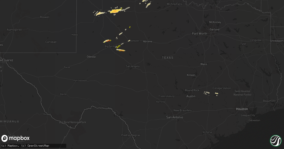
Hail Map in Texas on May 5, 2015
Get this storm
May 5 map
$229
one time, instant access
Download today. No call, no setup
Keep the $229
Bought the map and want the full workflow? Apply the entire $229 to a subscription within 7 days. None of it is wasted.
Every map, not just this one
This buys you this map. Subscription and you get every map we run, in the markets you choose from a few cities to whole states to nationwide. Plus real-time alerts the moment a storm fires.
Contact data
Name, contact info, occupancy, even credit band for addresses in the footprint. You go from where it hit to who to call.
Become the source they trust
Unlimited branding weather history reports on demand. You already have the documented answer ready for the property owner, and you are the one who showed up with it.
Property data and RoofTrace estimates
Pull up any address you have got, its value and the exact code rules for that jurisdiction, straight from One Click Code. Then RoofTrace estimates the squares, pitch, and roof value, priced the way you price.
Storm reports in Texas
Texas
| Date | Description |
|---|---|
| 05/05/20156:50 PM CDT | A local report indicates 1.00 inch wind near 2 N ROSCOE |
| 05/05/20156:42 PM CDT | A local report indicates 65 MPH wind near 6 ENE AMARILLO |
| 05/05/20156:36 PM CDT | Smaller hail covering the ground. |
| 05/05/20156:33 PM CDT | Relayed by media. |
| 05/05/20156:30 PM CDT | A local report indicates 60 MPH wind near 2 WNW CANYON |
| 05/05/20156:25 PM CDT | Corrected time. |
| 05/05/20156:24 PM CDT | Southbound i-27 near bell...tractor trailer overturned due to high winds. Radar estimated time. |
| 05/05/20156:21 PM CDT | Schoolnet site at oasis rv resort. |
| 05/05/20156:15 PM CDT | A large tree was uprooted in canyon |
| 05/05/20156:15 PM CDT | A local report indicates 60 MPH wind near 2 WNW CANYON |
| 05/05/20155:40 PM CDT | A local report indicates 1.00 inch wind near 7 SW COLORADO CITY |
| 05/05/20154:50 PM CDT | A local report indicates 1.00 inch wind near 2 NW SNYDER |
| 05/05/20153:21 PM CDT | A local report indicates a tornado near 4 W LUTHER |
| 05/05/20155:42 AM CDT | Trees down in indepedence at the intersection of fm-50 and fm-390. |
| 05/05/20155:26 AM CDT | Trees down in indepedence at the intersection of fm-50 and fm-390. |
| 05/05/20153:00 AM CDT | Reports of numerous trees down and hail in lexington. Did not have a hail size. |
| 05/04/201511:30 PM CDT | Delayed report. Time estimated from radar. |
| 05/04/20158:00 PM CDT | Brief touchdown observed on highway 163. Tornado was on the ground for one minute. Report relayed hy sterling county sheriff office. |
| 05/04/20157:47 PM CDT | A local report indicates 2.75 inch wind near 5 S CROSBYTON |
| 05/04/20157:33 PM CDT | Second tornado. Lasted from 727 to 733 pm. |
| 05/04/20157:24 PM CDT | Narrow tornado from 724 to 727 pm. |
| 05/04/20157:24 PM CDT | Short weak tornado |
| 05/04/20157:06 PM CDT | A local report indicates 60 MPH wind near TIMBERCREEK CANYON |
All States Impacted by Hail Map on May 5, 2015
Cities Impacted by Hail Map on May 5, 2015
- Downs, KS
- Gaylord, KS
- Osborne, KS
- Rensselaer, IN
- Brook, IN
- Morocco, IN
- Crosbyton, TX
- Ralls, TX
- Crowell, TX
- Lorenzo, TX
- Quanah, TX
- Giddings, TX
- Mcadoo, TX
- Dickens, TX
- Afton, TX
- Somerville, TX
- Lyons, TX
- Caldwell, TX
- Lubbock, TX
- Ropesville, TX
- Wolfforth, TX
- Levelland, TX
- Boyce, VA
- Guymon, OK
- Goodwell, OK
- Big Spring, TX
- Snyder, TX
- Paducah, TX
- Westbrook, TX
- Harbor Beach, MI
- Lexington, TX
- Lincoln, TX
- Lenorah, TX
- Knott, TX
- Coleman, TX
- Dime Box, TX
- Luray, KS
- Slaton, TX
- Ira, TX
- Roosevelt, OK
- Roscoe, TX
- Clyde, TX
- Tipton, KS
- East China, MI
- Apple Creek, OH
- Manzanola, CO
- Alton, KS
- Natoma, KS
- Colorado City, TX
- Ballinger, TX
- Brewster, OH
- Massillon, OH
- Navarre, OH
- Gruver, TX
- Seymour, TX
- Chillicothe, TX
- Vernon, TX
- Dalton, OH
- Crane, TX
- Coahoma, TX
- Albany, TX
- Brenham, TX
- Clearville, PA
- Rush, CO
- Talpa, TX
- The Plains, VA
- Portis, KS
- Port Huron, MI
- Millersburg, OH
- Esbon, KS
- Novice, TX
- Burwell, NE
- Shallowater, TX
- Roaring Spring, PA
- Anson, TX
- Stamford, TX
- Hamlin, TX
- Woodson, TX
- Throckmorton, TX
- Newcastle, TX
- Glen Elder, KS
- Rocky Ford, CO
- Eden, TX
- McCamey, TX
- Sterling City, TX
- Jayton, TX
- Sycamore, OH
- Upper Sandusky, OH
- Bucyrus, OH
- Tiro, OH
- Carey, OH
- San Jon, NM


