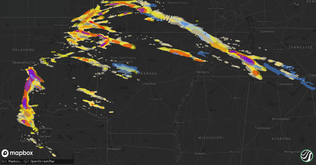
Hail Map in Arkansas on May 4, 2020
Get this storm
May 4 map
$229
one time, instant access
Download today. No call, no setup
Keep the $229
Bought the map and want the full workflow? Apply the entire $229 to a subscription within 7 days. None of it is wasted.
Every map, not just this one
This buys you this map. Subscription and you get every map we run, in the markets you choose from a few cities to whole states to nationwide. Plus real-time alerts the moment a storm fires.
Contact data
Name, contact info, occupancy, even credit band for addresses in the footprint. You go from where it hit to who to call.
Become the source they trust
Unlimited branding weather history reports on demand. You already have the documented answer ready for the property owner, and you are the one who showed up with it.
Property data and RoofTrace estimates
Pull up any address you have got, its value and the exact code rules for that jurisdiction, straight from One Click Code. Then RoofTrace estimates the squares, pitch, and roof value, priced the way you price.
Storm reports in Arkansas
Arkansas
| Date | Description |
|---|---|
| 05/04/20206:15 PM CDT | Large tree down on home. |
| 05/04/20205:30 PM CDT | Widespread damage. Trees down... Commercial building roof damaged. |
| 05/04/20205:20 PM CDT | A local report indicates 1.00 inch wind near PIGGOTT |
| 05/04/20205:15 PM CDT | Widespread damage. Trees down... Commercial building roof damaged. |
| 05/04/20205:12 PM CDT | Trees down across town. |
| 05/04/20203:30 PM CDT | Hail up to the size of quarters just southeast of lepanto. |
| 05/04/20203:02 PM CDT | Hail sized from quarter to golf ball on the south side of jonesboro. |
| 05/04/20202:50 PM CDT | Hail sized anywhere from quarter to ping pong in cash. |
| 05/04/20202:34 PM CDT | Public report of golf ball size hail in swifton. |
| 05/04/20202:31 PM CDT | 3 inch tree limbs and powerlines broken north of tuckerman. |
| 05/04/20202:03 PM CDT | Coop observer reports quarter size hail in cave city. |
| 05/04/20201:16 PM CDT | Public report of quarter size hail in oxford. |
| 05/04/202012:15 PM CDT | Storm spotter reports ping pong ball size hail. |
| 05/04/202012:15 PM CDT | Storm spotter reports ping pong ball size hail in jasper. |
| 05/04/202012:10 PM CDT | Public submitted pictures of ping pong ball size hail. |
| 05/04/202011:52 AM CDT | Coop observer reports quarter size hail. |
| 05/04/202010:50 AM CDT | A local report indicates 1.00 inch wind near 3 W BENTONVILLE |
| 05/04/202010:42 AM CDT | A local report indicates 3.00 inch wind near ROGERS |
| 05/04/202010:36 AM CDT | A local report indicates 1.00 inch wind near ROGERS |
| 05/04/202010:31 AM CDT | A local report indicates 1.25 inch wind near BELLA VISTA |
| 05/04/202010:17 AM CDT | A local report indicates 3.00 inch wind near FAYETTEVILLE |
| 05/04/202010:15 AM CDT | Automobile dented... Windshield broken. Dented metal roof. |
| 05/04/202010:15 AM CDT | A local report indicates 2.00 inch wind near CENTERTON |
| 05/04/202010:12 AM CDT | A local report indicates 2.50 inch wind near FAYETTEVILLE |
| 05/04/202010:11 AM CDT | A local report indicates 1.50 inch wind near JOHNSON |
| 05/04/20209:51 AM CDT | A local report indicates 1.75 inch wind near FAYETTEVILLE |
| 05/04/20209:50 AM CDT | A local report indicates 1.00 inch wind near FAYETTEVILLE |
| 05/04/20207:20 AM CDT | At 1220 PM CDT, a severe thunderstorm was located over Piercetown, or near Jasper, moving southeast at 30 mph. HAZARD...Two inch hail and 60 mph wind gusts. SOURCE...Radar indicated. IMPACT...People and animals outdoors will be injured. Expect hail damage to roofs, siding, windows, and vehicles. Expect wind damage to roofs, siding, and trees. Locations impacted include... Jasper... Marsena... Eula... Bohannon... Piercetown... Carver... Duff... Point Peter... St. Joe... Gilbert... Bass... Canaan... Yardelle... Silver Hill... Vendor... Gum Springs in Newton County... Mt Judea... Snowball... Hasty... Woolum Recreation Area... |
| 05/04/20206:51 AM CDT | At 1151 PM CDT, a severe thunderstorm was located over Ratcliff, or near Charleston, moving southeast at 40 mph. HAZARD...60 mph wind gusts and quarter size hail. SOURCE...Radar indicated. IMPACT...Hail damage to vehicles is expected. Expect wind damage to roofs, siding, and trees. Locations impacted include... Paris... Magazine... Subiaco... Ratcliff... Blue Mountain... Mount Magazine... Midway in Logan County... Lake Dardanelle... Belleville... Havana... Caulksville... Waveland... Chismville... Wilkins... Carbon City... Driggs... New Blaine... Corley... Spring Lake Campground... |
| 05/04/20206:46 AM CDT | At 1146 PM CDT, a severe thunderstorm was located 3 miles northwest of Branch, moving east at 45 mph. HAZARD...60 mph wind gusts and quarter size hail. SOURCE...Radar indicated. IMPACT...Hail damage to vehicles is expected. Expect wind damage to roofs, siding, and trees. Locations in or near the path include... Charleston... Altus... Branch... Denning... Wiederkehr Village... Etna... Peter Pender... Alix... Vesta... Meg... |
| 05/04/20206:39 AM CDT | At 1138 PM CDT, a severe thunderstorm was located near Atkins, or 10 miles west of Morrilton, moving east at 50 mph. HAZARD...60 mph wind gusts and quarter size hail. SOURCE...Radar indicated. IMPACT...Hail damage to vehicles is expected. Expect wind damage to roofs, siding, and trees. Locations impacted include... Conway... Morrilton... Perryville... Greenbrier... Atkins... Mayflower... Wooster... Oppelo... Menifee... Perry... Adona... Houston... Bethlehem... Sequoya Park... Hill Creek... Pickles Gap... Little Italy... Happy Bend... Solgohachia... Hattieville...This includes Interstate 40 between mile markers 94 and 141. |
| 05/04/20206:31 AM CDT | At 1131 AM CDT, severe thunderstorms were located along a line extending from Rudd to near Marble, moving east at 45 mph. HAZARD...Two inch hail and 60 mph wind gusts. SOURCE...Radar indicated. IMPACT...People and animals outdoors will be injured. Expect hail damage to roofs, siding, windows, and vehicles. Expect wind damage to roofs, siding, and trees. Locations impacted include... Harrison... Jasper... Western Grove... Valley Springs... Dugger... Olvey... Carver... Erbie... Red Bank... Lost Valley State Park... Capps... Piercetown... Pruitt... Crawford... Upper Buffalo Wilderness Area... Bellefonte... Everton... Zinc... Batavia... Marble Falls... |
| 05/04/20206:30 AM CDT | At 1130 PM CDT, a severe thunderstorm was located near Danville, moving east at 35 mph. HAZARD...60 mph wind gusts and quarter size hail. SOURCE...Radar indicated. IMPACT...Hail damage to vehicles is expected. Expect wind damage to roofs, siding, and trees. Locations impacted include... Danville... Ola... Plainview in Yell County... Petit Jean River WMA... Belleville... Havana... Aplin... Corinth... Birta... Carter Cove Park... Nimrod... Wing... Macedonia in Yell County... Deberrie... Waltreak... Kingston... Rover... Fourche Junction... Hollis... Fourche Mountain Recreation Are... |
| 05/04/20206:01 AM CDT | At 1101 PM CDT, a severe thunderstorm was located over Midway in Logan County, or 11 miles east of Paris, moving east at 50 mph. HAZARD...60 mph wind gusts and quarter size hail. SOURCE...Radar indicated. IMPACT...Hail damage to vehicles is expected. Expect wind damage to roofs, siding, and trees. Locations impacted include... Russellville... Dardanelle... Atkins... Pottsville... London... Knoxville... Subiaco... Scranton... Lake Dardanelle State Park... Carden Bottoms... Happy Bend... Mt Nebo State Park... Petit Jean State Park... Lake Dardanelle... Petit Jean River WMA... Galla Creek WMA... Midway in Logan County... Mosley... Tokalon... Taral...This includes Interstate 40 between mile markers 67 and 98. |
| 05/04/20205:59 AM CDT | At 1059 AM CDT, severe thunderstorms were located along a line extending from Hobbs State Park to 4 miles north of Marble, moving southeast at 40 mph. HAZARD...Golf ball size hail. SOURCE...Radar indicated. IMPACT...People and animals outdoors will be injured. Expect damage to roofs, siding, windows, and vehicles. Locations in or near the path include... Berryville... Huntsville... Eureka Springs... Green Forest... Hindsville... Carrollton... Rudd... Kingston... Forum... Hobbs State Park... Clifty... Withrow Springs State Park... War Eagle... Marble... Osage... Rule... Dryfork... Beaver Lake... Metalton... Connor... |
| 05/04/20201:11 AM CDT | At 611 PM CDT, a severe thunderstorm was located near Dell, or 7 miles southeast of Manila, moving southeast at 50 mph. HAZARD...60 mph wind gusts. SOURCE...Radar indicated. IMPACT...Expect damage to roofs, siding, and trees. Locations impacted include... Blytheville, Ripley, Osceola, Luxora, Wilson, Keiser, Fort Pillow State Park, Dell, Burdette, Marie, Fulton, Ashport, Ft Pillow, Dixonville, Little River, Henning, Gilt Edge, Burlison, Etowah and Garland. |
| 05/03/202011:59 PM CDT | At 459 PM CDT, a severe thunderstorm was located near Qulin, or 10 miles northwest of Chalk Bluff Natural Area, moving east at 55 mph. HAZARD...60 mph wind gusts and quarter size hail. SOURCE...Radar indicated. IMPACT...Hail damage to vehicles is expected. Expect wind damage to roofs, siding, and trees. Locations impacted include... Campbell, Chalk Bluff Natural Area, Malden, Clarkton, St. Francis, Pollard, McDougal, Saint Francis, Glennonville, Valley Ridge, Providence, Morris State Park, Wilhelmina, Brian, Chalk Bluff Battlefield Park, Baird, McGuires and Townley. |
| 05/03/202011:28 PM CDT | Reported on north side of town by fort smith pd. |
| 05/03/202011:24 PM CDT | 1 inch hail in dardanelle. |
| 05/03/202010:36 PM CDT | At 336 PM CDT, a severe thunderstorm was located over Dyess, or 8 miles west of Wilson, moving east at 50 mph. HAZARD...60 mph wind gusts and quarter size hail. SOURCE...Radar indicated. IMPACT...Hail damage to vehicles is expected. Expect wind damage to roofs, siding, and trees. Locations impacted include... Bartlett, Millington, Covington, Osceola, Lepanto, Wilson, Tyronza, Keiser, Meeman Shelby Forest State Park, Fort Pillow State Park, Memphis, Arlington, Munford, Brighton, Joiner, Dyess, Gilmore, Bassett, Marie and Fulton. |
| 05/03/202010:06 PM CDT | At 305 PM CDT, a severe thunderstorm was located near Greenfield, or near Jonesboro, moving east at 45 mph. HAZARD...60 mph wind gusts and half dollar size hail. SOURCE...Trained weather spotters. At 302 PM, quarter to golf ball size hail was reported south of Jonesboro. IMPACT...Hail damage to vehicles is expected. Expect wind damage to roofs, siding, and trees. Locations impacted include... Jonesboro, Trumann, Marked Tree, Lake City, Lepanto, Bay, Caraway, Tyronza, Keiser, Dyess, Greenfield, Little River, Etowah, Black Oak, Birdsong, Payneway, Apt, Dimple, Eastview and Lennie. |
| 05/03/20209:31 PM CDT | At 230 PM CDT, a severe thunderstorm was located over Swifton, or 14 miles north of Newport, moving east at 50 mph. HAZARD...Ping pong ball size hail and 60 mph wind gusts. SOURCE...Radar indicated. IMPACT...People and animals outdoors will be injured. Expect hail damage to roofs, siding, windows, and vehicles. Expect wind damage to roofs, siding, and trees. Locations impacted include... Jonesboro, Harrisburg, Bono, Bay, Brookland, Weiner, Cash, Egypt, Greenfield, Hergett, Apt, Valley View, Farrville, Dorothy, Winesburg, Uno, Cary, Lanieve, Herndon and Pitts. |
| 05/03/20209:10 PM CDT | At 209 PM CDT, a severe thunderstorm was located near Cave City, or 14 miles northeast of Batesville, moving east at 50 mph. Quarter size hail has been reported with this storm. HAZARD...60 mph wind gusts and quarter size hail. SOURCE...Public. IMPACT...Hail damage to vehicles is expected. Expect wind damage to roofs, siding, and trees. Locations impacted include... Cave City... Tuckerman... Swifton... Strawberry... Alicia... Minturn... Aetna... Charlotte... Strangers Home... Gainesboro... Pfeiffer... Calvin... Dowdy... Kenyon... Driftwood... Cord... Elgin... This includes US Highway 67 between mile markers 96 and 100, andbetween mile markers 109 and 114. |
| 05/03/20208:43 PM CDT | At 143 PM CDT, severe thunderstorms were located along a line extending from 10 miles southeast of Ash Flat to near Croker, moving east at 55 mph. HAZARD...60 mph wind gusts and quarter size hail. SOURCE...Radar indicated. IMPACT...Hail damage to vehicles is expected. Expect wind damage to roofs, siding, and trees. Locations impacted include... Walnut Ridge... Melbourne... Black Rock... Lake Charles State Park... Cave City... College City... Cushman... Portia... Mount Pleasant... Strawberry... Lynn... Sidney... Annieville... Croker... Gid... Stella... Lunenburg... Evening Shade... Guion... Smithville... |
| 05/03/20208:11 PM CDT | At 111 PM CDT, a severe thunderstorm was located over Culp, or 15 miles northwest of Mountain View, moving east at 45 mph. HAZARD...60 mph wind gusts and quarter size hail. SOURCE...Radar indicated. IMPACT...Hail damage to vehicles is expected. Expect wind damage to roofs, siding, and trees. Locations impacted include... Melbourne... Calico Rock... Mount Pleasant... Pineville... Franklin... Gid... Stella... Lunenburg... Culp... Lacrosse... Lone Star... Gorby... Mt Olive in Izard County... Zion... Boswell... Optimus... Sage... Larkin... Barkshed Campground... Sylamore Shooting Range... |
| 05/03/20208:09 PM CDT | At 109 PM CDT, a severe thunderstorm was located over Wideman, or 12 miles northwest of Melbourne, moving east at 45 mph. HAZARD...60 mph wind gusts and quarter size hail. SOURCE...Radar indicated. IMPACT...Hail damage to vehicles is expected. Expect wind damage to roofs, siding, and trees. Locations impacted include... Cherokee Village... Ash Flat... Horseshoe Bend... Highland in Sharp County... Hardy... Oxford... Franklin... Ballard... Bexar... Myron... Wideman... Agnos... Center... Glencoe... Morriston... Violet Hill... Union... Kittle... Wiseman... Brockwell... |
All States Impacted by Hail Map on May 4, 2020
Cities Impacted by Hail Map on May 4, 2020
- Piqua, KS
- Moran, KS
- Elsmore, KS
- Uniontown, KS
- La Harpe, KS
- Walker, MO
- Fulton, KS
- Fort Scott, KS
- Bronson, KS
- Nevada, MO
- Humboldt, KS
- Kincaid, KS
- Richards, MO
- Iola, KS
- Redfield, KS
- Hume, MO
- Springdale, AR
- Lowell, AR
- Prairie Grove, AR
- Fayetteville, AR
- Farmington, AR
- Elkins, AR
- Noble, OK
- Norman, OK
- Lexington, OK
- Macomb, OK
- Wanette, OK
- Henderson, TN
- Finger, TN
- Bethel Springs, TN
- Wilburton, OK
- Hartford, KS
- Burlington, KS
- Ada, OK
- Abilene, KS
- Salina, KS
- Solomon, KS
- New Cambria, KS
- Alpena, AR
- Harrison, AR
- Compton, AR
- Berryville, AR
- Huntsville, AR
- Jasper, AR
- Green Forest, AR
- Marble Falls, AR
- Pauls Valley, OK
- New Market, AL
- Lockwood, MO
- Grandin, MO
- Florence, AL
- Collinwood, TN
- Savannah, TN
- Waynesboro, TN
- Iron City, TN
- Cypress Inn, TN
- Olivehill, TN
- Lutts, TN
- Broken Bow, OK
- Decaturville, TN
- Darden, TN
- Parsons, TN
- Niangua, MO
- Bragg City, MO
- Stratford, OK
- Smithville, OK
- Riley, KS
- Fontana, KS
- Parker, KS
- La Cygne, KS
- Granby, MO
- Neosho, MO
- Carrollton, TX
- Okemah, OK
- Nocona, TX
- Saint Jo, TX
- South Greenfield, MO
- Waverly, KS
- Vanzant, MO
- Drury, MO
- Vinita, OK
- Swifton, AR
- Wilson, OK
- Siloam Springs, AR
- Medon, TN
- Union, SC
- Danville, AR
- Afton, OK
- Okmulgee, OK
- Morris, OK
- Timmonsville, SC
- Elliott, SC
- Lynchburg, SC
- Lamar, SC
- Bishopville, SC
- Osceola, MO
- Lowry City, MO
- Mansfield, AR
- Huntington, AR
- Columbus, KS
- Baxter Springs, KS
- Galena, KS
- Riverton, KS
- Jay, OK
- Red Oak, TX
- Waxahachie, TX
- Jonesboro, AR
- Everton, MO
- Greenfield, MO
- Burneyville, OK
- Overbrook, OK
- Ringling, OK
- Lake Dallas, TX
- Republic, MO
- Ozark, MO
- Nixa, MO
- Rogersville, MO
- Clever, MO
- Springfield, MO
- Brookline, MO
- Billings, MO
- Elmore City, OK
- Newalla, OK
- Paoli, OK
- Roff, OK
- Wayne, OK
- Byars, OK
- Maysville, OK
- Hennepin, OK
- Sulphur, OK
- Tecumseh, OK
- Davis, OK
- Wynnewood, OK
- Eucha, OK
- Butler, MO
- Oak Grove, AR
- Cleveland, GA
- Cornelia, GA
- Garvin, OK
- Catoosa, OK
- Inola, OK
- Claremore, OK
- Wickes, AR
- Honobia, OK
- Bethel, OK
- Watson, OK
- Nashoba, OK
- Grannis, AR
- Chester, SC
- Spavinaw, OK
- Strang, OK
- Picher, OK
- Quapaw, OK
- Miami, OK
- Commerce, OK
- North Miami, OK
- Hartville, MO
- Mansfield, MO
- Minneapolis, KS
- Delphos, KS
- Nowata, OK
- Sharon, TN
- Garland, KS
- Arcadia, KS
- Bronaugh, MO
- Reading, KS
- Madison, KS
- Oronogo, MO
- Webb City, MO
- Carthage, MO
- Joplin, MO
- Detroit, TX
- Clay Center, KS
- Miltonvale, KS
- Roland, AR
- Perryville, AR
- Lamar, MO
- Fort Gibson, OK
- Hulbert, OK
- Tahlequah, OK
- Williamsburg, KS
- Garnett, KS
- Carl Junction, MO
- Lebo, KS
- Emporia, KS
- Neosho Rapids, KS
- Diamond, MO
- Alicia, AR
- Batesville, AR
- Sulphur Rock, AR
- Cord, AR
- Harrisburg, AR
- Cave City, AR
- Trumann, AR
- Mount Pleasant, AR
- Sidney, AR
- Cash, AR
- Saffell, AR
- Tuckerman, AR
- Bay, AR
- Newark, AR
- Weiner, AR
- Manhattan, KS
- Pryor, OK
- Dyersburg, TN
- Milan, TN
- Humboldt, TN
- Lavinia, TN
- Medina, TN
- Gadsden, TN
- Wyandotte, OK
- Seneca, MO
- Lexington, TN
- Muskogee, OK
- Cedar Hill, TX
- Midlothian, TX
- Strong City, KS
- Sardis, TN
- Alton, MO
- Beech Bluff, TN
- Obion, TN
- Gideon, MO
- Westpoint, TN
- Kennett, MO
- Oakfield, TN
- Caruthersville, MO
- Trenton, TN
- Van Buren, MO
- Hayti, MO
- Linden, TN
- Harviell, MO
- Holcomb, MO
- Newbern, TN
- Lawrenceburg, TN
- Rector, AR
- Cedar Grove, TN
- Qulin, MO
- Ridgely, TN
- Jackson, TN
- Dyer, TN
- Halls, TN
- Steele, MO
- Saltillo, TN
- Fremont, MO
- Campbell, MO
- Saint Francis, AR
- Doniphan, MO
- Scotts Hill, TN
- Broseley, MO
- Alamo, TN
- Pollard, AR
- Fairdealing, MO
- Clarkton, MO
- Wardell, MO
- Winona, MO
- Corning, AR
- Finley, TN
- Piggott, AR
- Bath Springs, TN
- Neelyville, MO
- Reagan, TN
- Huron, TN
- Clifton, TN
- Oxly, MO
- Wildersville, TN
- Malden, MO
- Poplar Bluff, MO
- Friendship, TN
- Gibson, MO
- Birch Tree, MO
- Naylor, MO
- Portageville, MO
- Greenway, AR
- Asher, OK
- Bennington, KS
- Tescott, KS
- Rogers, AR
- Bentonville, AR
- Little Elm, TX
- Aubrey, TX
- Moundville, MO
- Sheldon, MO
- Milo, MO
- Junction City, KS
- Dwight, KS
- Honea Path, SC
- Belton, SC
- Arlington, TX
- Grand Prairie, TX
- Marionville, MO
- Aurora, MO
- Archie, MO
- Washburn, MO
- Seligman, MO
- La Russell, MO
- Duenweg, MO
- Sarcoxie, MO
- Rocky Comfort, MO
- Powell, MO
- Goodman, MO
- Stella, MO
- Chetopa, KS
- Cassville, MO
- Reeds, MO
- Treece, KS
- Anderson, MO
- Welch, OK
- Eagle Rock, MO
- Exeter, MO
- Fairland, OK
- Pineville, MO
- Pittsburg, KS
- Rich Hill, MO
- Bucyrus, MO
- Kansas, OK
- Rose, OK
- Oaks, OK
- Calico Rock, AR
- Big Cabin, OK
- Hugo, OK
- Boswell, OK
- Weaubleau, MO
- Bolivar, MO
- Half Way, MO
- Urbana, MO
- Wheatland, MO
- Tunas, MO
- Collins, MO
- Pittsburg, MO
- Buffalo, MO
- Long Lane, MO
- Humansville, MO
- Flemington, MO
- Polk, MO
- Louisburg, MO
- Hermitage, MO
- Ponca, AR
- Western Grove, AR
- Hasty, AR
- Woodruff, SC
- Pauline, SC
- Roebuck, SC
- Enoree, SC
- The Colony, TX
- Lewisville, TX
- Paradise, TX
- Howe, OK
- Poteau, OK
- Yukon, MO
- Cabool, MO
- Summersville, MO
- Willow Springs, MO
- Elk Creek, MO
- Chatfield, TX
- Kerens, TX
- Rice, TX
- Kemp, TX
- Decatur, TX
- Osage City, KS
- De Queen, AR
- Gillham, AR
- Umpire, AR
- Dierks, AR
- Saratoga, AR
- Fulton, AR
- Norwood, MO
- Hillsboro, TX
- Magazine, AR
- Blue Mountain, AR
- Havana, AR
- Lincoln, KS
- Beverly, KS
- Joiner, AR
- Dyess, AR
- Vian, OK
- Glasco, KS
- Concordia, KS
- Kershaw, SC
- Jefferson, SC
- Centerville, TN
- Hohenwald, TN
- Solo, MO
- West Plains, MO
- Lenox, TN
- Mountain View, MO
- Eminence, MO
- Gobler, MO
- Mountain Grove, MO
- Tiptonville, TN
- Enterprise, KS
- Blue Mound, KS
- Salina, OK
- Elkland, MO
- Fair Grove, MO
- Jasper, MO
- Neck City, MO
- Purcell, MO
- Alba, MO
- Edgerton, KS
- Gardner, KS
- Tonganoxie, KS
- Linwood, KS
- Covington, TN
- Brighton, TN
- Dallas, TX
- Adair, OK
- West, TX
- Abbott, TX
- Kansas City, MO
- Lebanon, MO
- Alta Vista, KS
- Wamego, KS
- Gypsum, KS
- Alma, KS
- Paxico, KS
- Chapman, KS
- Topeka, KS
- Silver Lake, KS
- Rossville, KS
- Fort Riley, KS
- McFarland, KS
- Maple Hill, KS
- Ogden, KS
- Falcon, MO
- Conway, MO
- Pleasant Hope, MO
- Willard, MO
- Aldrich, MO
- Lynchburg, MO
- Dadeville, MO
- Morrisville, MO
- Walnut Grove, MO
- Seymour, MO
- Plato, MO
- Marshfield, MO
- Brighton, MO
- Grovespring, MO
- Phillipsburg, MO
- Huggins, MO
- Ash Grove, MO
- Graff, MO
- Delaware, OK
- Lenapah, OK
- Charleston, AR
- Fort Smith, AR
- Sylvan Grove, KS
- Olanta, SC
- Greeley, KS
- Lane, KS
- Forestburg, TX
- Mount Pleasant, TN
- Locust Grove, OK
- Hartsville, SC
- Society Hill, SC
- Patrick, SC
- Muenster, TX
- Welling, OK
- Bunch, OK
- Stevenson, AL
- Hazel Green, AL
- Elora, TN
- Flintville, TN
- Melvern, KS
- Licking, MO
- Yellville, AR
- Hornersville, MO
- Ola, AR
- Richmond, KS
- Stockton, MO
- Jonesville, SC
- Grove, OK
- Pomona, KS
- Amoret, MO
- Amsterdam, MO
- Lavaca, AR
- Gans, OK
- Roland, OK
- Gore, OK
- Sallisaw, OK
- Barling, AR
- Alma, AR
- Oktaha, OK
- Arkoma, OK
- Muldrow, OK
- Braggs, OK
- Van Buren, AR
- Ratcliff, AR
- Branch, AR
- Greenwood, AR
- Park Hill, OK
- Paris, AR
- Booneville, AR
- Eureka Springs, AR
- Garfield, AR
- McKenzie, TN
- Huntingdon, TN
- Trezevant, TN
- Hartwell, GA
- Wellsville, KS
- Chouteau, OK
- Gravette, AR
- Centerton, AR
- Hiwasse, AR
- Montague, TX
- Barnard, KS
- Bella Vista, AR
- West Fork, AR
- Hindsville, AR
- Winthrop, AR
- Wright City, OK
- Horatio, AR
- Lockesburg, AR
- Eagletown, OK
- Haworth, OK
- Valliant, OK
- Mercer, TN
- Denmark, TN
- Chanute, KS
- Erie, KS
- Garden City, MO
- Preston, MO
- Princeton, KS
- Ottawa, KS
- Paola, KS
- Osawatomie, KS
- Rantoul, KS
- Duncan, SC
- Greer, SC
- Bluejacket, OK
- Vendor, AR
- Pomona, MO
- Mount Judea, AR
- Fairview, MO
- Purdy, MO
- Houston, MO
- Miller, MO
- Weir, KS
- Asbury, MO
- Ellsinore, MO
- Westville, OK
- Broken Arrow, OK
- Waterloo, AL
- Proctor, OK
- Tiff City, MO
- Pierce City, MO
- Talala, OK
- Scammon, KS
- Enville, TN
- Stark City, MO
- Wagoner, OK
- Stilwell, OK
- Kingston, AR
- Oologah, OK
- Golden City, MO
- Decatur, AR
- Ketchum, OK
- Summers, AR
- Morris Chapel, TN
- Colcord, OK
- Bernie, MO
- Liberal, MO
- Cave Springs, AR
- Maysville, AR
- Hornbeak, TN
- Gentry, AR
- Bartlett, KS
- Luray, TN
- Chelsea, OK
- Strafford, MO
- Bells, TN
- Saint Joe, AR
- Golden, MO
- Monett, MO
- Lincoln, AR
- Cheraw, SC
- Roanoke, TX
- Southlake, TX
- Verona, MO
- Mount Vernon, MO
- Freistatt, MO
- Haskell, OK
- Taft, OK
- Porter, OK
- Warsaw, MO
- Waldron, AR
- Toccoa, GA
- Greenville, SC
- Moore, SC
- Raymondville, MO
- Mounds, OK
- Bixby, OK
- Evening Shade, AR
- Poughkeepsie, AR
- Clarkson, KY
- Longford, KS
- Louisburg, KS
- Dardanelle, AR
- Healdton, OK
- Taylors, SC
- Hillsboro, KS
- Marion, KS
- Grapevine, TX
- Flower Mound, TX
- Stark, KS
- Simpsonville, SC
- Smithville, AR
- Horseshoe Bend, AR
- Celina, TX
- Herington, KS
- Hope, KS
- Tampa, KS
- Westport, TN
- Yuma, TN
- Rudy, AR
- Mountainburg, AR
- Cedarville, AR
- Chester, AR
- Fayetteville, TN
- Lynchburg, TN
- Shelbyville, TN
- Petersburg, TN
- Due West, SC
- Elizabeth, AR
- Cotter, AR
- Flippin, AR
- Tishomingo, OK
- Woodbine, KS
- Pleasanton, KS
- Paragould, AR
- Cardwell, MO
- Mission, KS
- Seminole, OK
- Weleetka, OK
- Bull Shoals, AR
- Collinsville, OK
- Owasso, OK
- Elsberry, MO
- Silex, MO
- Tyronza, AR
- Strawberry, AR
- Melbourne, AR
- Lake City, AR
- Drummonds, TN
- Guion, AR
- Lepanto, AR
- Marked Tree, AR
- Wilson, AR
- Belfast, TN
- Culleoka, TN
- Cornersville, TN
- Lynnville, TN
- Lewisburg, TN
- Lincolnville, KS
- Wilsey, KS
- Burdick, KS
- Denton, TX
- Scurry, TX
- Rosser, TX
- Fair Play, MO
- Azle, TX
- Springtown, TX
- Spartanburg, SC
- Fort Worth, TX
- Hurst, TX
- North Richland Hills, TX
- Kelso, TN
- Lone Grove, OK
- Cottonwood Falls, KS
- Columbia, TN
- Hampshire, TN
- Columbus, AR
- Washington, AR
- Leon, OK
- Springer, OK
- Argyle, TX
- Ratliff City, OK
- Valley View, TX
- Graham, OK
- Bowie, TX
- Gainesville, TX
- Sanger, TX
- Krum, TX
- Thackerville, OK
- Era, TX
- Rosston, TX
- Marietta, OK
- Alvord, TX
- Lindsay, TX
- Sunset, TX
- Ardmore, OK
- Beggs, OK
- Franklin, AR
- Winchester, TN
- Shawnee, KS
- Kansas City, KS
- Overbrook, KS
- Haltom City, TX
- Bonner Springs, KS
- Mound City, KS
- Prescott, KS
- Baldwin City, KS
- Adrian, MO
- Lyndon, KS
- Quenemo, KS
- Americus, KS
- Westphalia, KS
- Harrisonville, MO
- Admire, KS
- Olpe, KS
- Drexel, MO
- Violet Hill, AR
- Wiseman, AR
- Wideman, AR
- Oxford, AR
- White City, KS
- Lindsborg, KS
- Eskridge, KS
- Lecompton, KS
- Lyman, SC
- Inman, SC
- Travelers Rest, SC
- Buffalo, SC
- Mauldin, SC
- Hartshorn, MO
- Frankewing, TN
- Fordland, MO
- Whitesboro, TX
- Atwood, TN
- Canehill, AR
- Idabel, OK
- Henning, TN
- Brownsville, TN
- Ripley, TN
- Heath Springs, SC
- Myrtle Beach, SC
- Blytheville, AR
- Ringold, OK
- Clyde, KS
- Clifton, KS
- Jerico Springs, MO
- El Dorado Springs, MO
- Farlington, KS
- Arma, KS
- Hepler, KS
- Sugar Tree, TN
- Holladay, TN
- Prague, OK
- Paden, OK
- Hartford, AR
- Mcalester, OK
- Rattan, OK
- New Blaine, AR
- Delaware, AR
- Mckinney, TX
- Castle, OK
- Boley, OK
- Scranton, KS
- Carbondale, KS
- Mayesville, SC
- Lucas, KS
- Foster, MO
- Benedict, KS
- Walnut, KS
- Troy, TN
- Kenton, TN
- Rives, TN
- Nashville, AR
- Bedford, TX
- Euless, TX
- Windyville, MO
- Wakefield, KS
- Gleason, TN
- Dorrance, KS
- Harwood, MO
- Stroud, OK
- Plainview, AR
- Casa, AR
- Appleton City, MO
- Lancaster, TX
- Desoto, TX
- Freeman, MO
- Cleveland, MO
- Ferris, TX
- Bristow, OK
- Pottsville, AR
- Russellville, AR
- Cameron, OK
- Seagoville, TX
- Manila, AR
- Dresden, TN
- Henry, TN
- Vassar, KS
- Estillfork, AL
- Princeton, AL
- Taft, TN
- Belvidere, TN
- Huntland, TN
- Hodges, SC
- Paris, TX
- Atkins, AR
- Quincy, MO
- Arbyrd, MO
- Rockville, MO
- Boynton, OK
- Colleyville, TX
- Tulsa, OK
- Council Grove, KS
- Subiaco, AR
- Leitchfield, KY
- York, SC
- Sharon, SC
- McConnells, SC
- Ozark, AR
- Shawnee, OK
- Mcloud, OK
- Spring Hill, KS
- Centerville, KS
- Dell, AR
- Smith Center, KS
- Dunnegan, MO
- Anderson, SC
- Mount Airy, GA
- Creighton, MO
- Schell City, MO
- Clarkesville, GA
- Demorest, GA
- Burlison, TN
- Iva, SC
- Starr, SC
- Leachville, AR
- Hartshorne, OK
- Bennettsville, SC
- Ashdown, AR
- Morrilton, AR
- Mulberry, TN
- Haslet, TX
- Keller, TX
- Blum, TX
- Weatherford, TX
- Greenfield, TN
- Bradford, TN
- Whiteville, TN
- Fort Towson, OK
- Sawyer, OK
- Plano, TX
- Allen, TX
- Alcolu, SC
- Watts, OK
- Oklahoma City, OK
- Belleville, AR
- Fitzhugh, OK
- Stonewall, OK
- Lebanon, OK
- Madill, OK
- Mountain Home, AR
- Mulberry, AR
- London, AR
- Lamar, AR
- Altus, AR
- Coal Hill, AR
- Knoxville, AR
- Scranton, AR
- Hackett, AR
- Midland, AR
- Bennington, OK
- Ramona, KS
- Stotts City, MO
- Prosper, TX
- Prairie Village, KS
- Overland Park, KS
- Hartman, AR
- Milford, KS
- Nunnelly, TN
- Meeker, OK
- Sparks, OK
- Ennis, TX
- Dover, AR
- Clayton, OK
- Clarksville, AR
- Gassville, AR
- Dolph, AR
- Sage, AR
- Morgan, TX
- McEwen, TN
- Hurricane Mills, TN
- Adamsville, TN
- Crump, TN
- Pilot Point, TX
- Mill Creek, OK
- Coweta, OK
- Duncanville, TX
- China Spring, TX
- Omaha, AR
- Lead Hill, AR
- Rutherford, TN
- Beloit, KS
- Salem, MO
- Urich, MO
- Clinton, MO
- Macomb, MO
- Success, MO
- Fisk, MO
- Resaca, GA
- Dawsonville, GA
- Dahlonega, GA
- Ellijay, GA
- Long Creek, SC
- Calhoun, GA
- Fairmount, GA
- Westminster, SC
- Talking Rock, GA
- Sugar Valley, GA
- Sautee Nacoochee, GA
- Jasper, GA
- Ranger, GA
- Marble Hill, GA
- Scottsboro, AL
- Summertown, TN
- Dellrose, TN
- Goodspring, TN
- Ethridge, TN
- Ardmore, TN
- Pulaski, TN
- Prospect, TN
- Estill Springs, TN
- Tullahoma, TN
- Trion, GA
- Valley Head, AL
- Pisgah, AL
- La Fayette, GA
- Fackler, AL
- Hollywood, AL
- Henagar, AL
- Summerville, GA
- Mentone, AL
- Menlo, GA
- Ider, AL
- Higdon, AL
- Rising Fawn, GA
- Flat Rock, AL
- Keiser, AR
- Etowah, AR
- Luxora, AR
- Osceola, AR
- Hattieville, AR
- Frisco, TX
- Blenheim, SC
- Chesterfield, SC
- Ruby, SC
- McBee, SC
- Pageland, SC
- Mount Croghan, SC
- Lancaster, SC
- Seneca, SC
- Liberty, SC
- Easley, SC
- Piedmont, SC
- Gaffney, SC
- Rock Hill, SC
- Clover, SC
- Hickory Grove, SC
- Smyrna, SC
- Pacolet, SC
- Bunker Hill, KS
- Russell, KS
- Wilson, KS
- Mapleton, KS
- Konawa, OK
- Foster, OK
- Kellyville, OK
- Killen, AL
- Everton, AR
- Pindall, AR
- Sulphur Springs, AR
- Carterville, MO
- Avilla, MO
- Dora, MO
- Puxico, MO
- S Coffeyville, OK
- Rover, AR
- Grantville, KS
- De Soto, KS
- Lenexa, KS
- Tecumseh, KS
- Basehor, KS
- Lawrence, KS
- Perry, KS
- Harveyville, KS
- Lone Jack, MO
- Olathe, KS
- New Century, KS
- Bucyrus, KS
- Grain Valley, MO
- Stilwell, KS
- Eudora, KS
- Grandview, MO
- Lees Summit, MO
- Burlingame, KS
- Greenwood, MO
- Peculiar, MO
- Pleasant Hill, MO
- Belton, MO
- Leawood, KS
- Raymore, MO
- Elmdale, KS
- Glade, KS
- Stockton, KS
- Kirwin, KS
- Norton, KS
- Clayton, KS
- Jennings, KS
- Lenora, KS
- Hill City, KS
- Morland, KS
- Woodston, KS
- Alton, KS
- Gaylord, KS
- Mankato, KS
- Esbon, KS
- Lebanon, KS
- Walnut Ridge, AR
- Bono, AR


