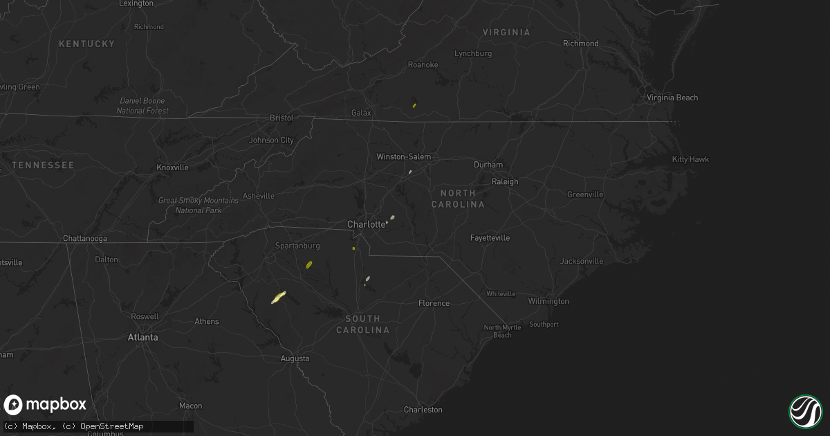
Hail Map in North Carolina on May 3, 2025
Get this storm
May 3 map
$229
one time, instant access
Download today. No call, no setup
Keep the $229
Bought the map and want the full workflow? Apply the entire $229 to a subscription within 7 days. None of it is wasted.
Every map, not just this one
This buys you this map. Subscription and you get every map we run, in the markets you choose from a few cities to whole states to nationwide. Plus real-time alerts the moment a storm fires.
Contact data
Name, contact info, occupancy, even credit band for addresses in the footprint. You go from where it hit to who to call.
Become the source they trust
Unlimited branding weather history reports on demand. You already have the documented answer ready for the property owner, and you are the one who showed up with it.
Property data and RoofTrace estimates
Pull up any address you have got, its value and the exact code rules for that jurisdiction, straight from One Click Code. Then RoofTrace estimates the squares, pitch, and roof value, priced the way you price.
Storm reports in North Carolina
North Carolina
| Date | Description |
|---|---|
| 05/03/20254:20 PM CDT | Trees down at tennessee st and pennsylvania ave. |
| 05/03/20254:15 PM CDT | Tree down on utility equipment. |
| 05/03/20253:54 PM CDT | Trees down on utility equipment. |
| 05/03/20253:44 PM CDT | Tree down on utility equipment. |
| 05/03/20253:35 PM CDT | Thunderstorm winds blew down one tree near the 200 block of bald hill loop just south of highway 704. |
| 05/03/20252:35 PM CDT | Thunderstorm winds blew down several trees near the intersection of highway 65 and easley road. |
| 05/03/20252:15 PM CDT | Two trees down at old beatty ford rd and emmanuel church rd. |
| 05/03/20253:58 AM CDT | Corrects previous tstm wnd dmg report from 4 sw four oaks. Multiple trees snapped off and a large tree uprooted in the 2400 block of parkertown rd. Corrected for time. |
| 05/03/20252:58 AM CDT | Multiple trees snapped off and a large tree uprooted in the 2400 block of parkertown rd. |
| 05/03/202512:33 AM CDT | Power outage attributed to fallen trees/limbs around long bow rd. Time estimated from radar. |
| 05/03/202512:05 AM CDT | Large tree blocking roadway...shiloh rd at doodle dr. Time estimated from radar and obs. |
| 05/03/202512:00 AM CDT | Power outage attributed to fallen trees/limbs between univ city blvd and e wt harris blvd. |
| 05/03/202512:00 AM CDT | Trees down near junction of cattlemans rd and mtn view rd. Time estimated. |
| 05/02/202510:21 PM CDT | Trees down at youngblood rd and mckee rd... And west to catawba river on adjacent roadways. |
All States Impacted by Hail Map on May 3, 2025
Cities Impacted by Hail Map on May 3, 2025
- Earlton, NY
- Climax, NY
- West Coxsackie, NY
- Coxsackie, NY
- Stuyvesant, NY
- Valatie, NY
- Old Chatham, NY
- Wurtsboro, NY
- Hodges, SC
- Abbeville, SC
- Greenwood, SC
- Highland, NY
- New Paltz, NY
- Clintondale, NY
- Waterloo, SC
- Ulster Park, NY
- Ridgeway, SC
- Bassett, VA
- Patrick Springs, VA
- Heath Springs, SC
- Locust, NC
- Midland, NC
- Mount Pleasant, NC
- Erving, MA
- Lake Pleasant, MA
- Montague, MA
- Millers Falls, MA
- Turners Falls, MA
- Deerfield, MA
- Gill, MA
- Northfield, MA
- South Deerfield, MA
- Buffalo, SC
- Union, SC
- Enoree, SC
- Leverett, MA
- Sunderland, MA
- Thomasville, NC
- Germantown, MD
- Boyds, MD
- Damascus, MD
- Gaithersburg, MD
- Clarksburg, MD
- Winnsboro, SC
- Peterborough, NH
- Jaffrey, NH
- Rindge, NH
- Fitzwilliam, NH
- Dublin, NH
- Temple, NH
- Greenfield, NH
- Lyndeborough, NH
- Huntington, MA
- Otis, MA
- Westfield, MA
- Blandford, MA
- East Otis, MA
- Russell, MA
- Granville, MA
- Easthampton, MA
- Southampton, MA
- Southwick, MA
- Brookeville, MD
- Woodbine, MD
- Exeter, NH
- Hampton Falls, NH
- Hampton, NH
- Mount Airy, MD
- Cooksville, MD
- Glenwood, MD
- Rye, NH
- Rye Beach, NH
- North Hampton, NH
- Ludowici, GA
- West Springfield, MA
- South Hadley, MA
- Northampton, MA
- Hadley, MA
- Amherst, MA
- Holyoke, MA
- Ludlow, MA
- Chicopee, MA
- Granby, MA
- Montgomery Village, MD
- Sykesville, MD
- Glenelg, MD
- West Friendship, MD
- Catawba, SC
- Rock Hill, SC
- Fernandina Beach, FL
- Marriottsville, MD
- Winchester, VA
- Belchertown, MA
- Ware, MA
- Three Rivers, MA
- Wilbraham, MA
- Springfield, MA
- Indian Orchard, MA
- Palmer, MA
- West Brookfield, MA
- Bondsville, MA
- North Brookfield, MA
- Thorndike, MA
- West Warren, MA
- Warren, MA
- Gilbertville, MA
- Hardwick, MA
- New Braintree, MA
- Woodstock, MD
- Ellicott City, MD
- Randallstown, MD
- Owings Mills, MD
- Pikesville, MD
- Stevenson, MD
- Hollis, NH
- Dickerson, MD
- Bunker Hill, WV
- Brookline, NH
- Clear Brook, VA
- Yulee, FL
- Windsor Mill, MD
- Nashua, NH
- Greenville, NH
- Milford, NH
- Amherst, NH
- Merrimack, NH
- West Granby, CT
- West Simsbury, CT
- Canton, CT
- Barkhamsted, CT
- Simsbury, CT
- Granby, CT
- New Hartford, CT
- Longmeadow, MA
- West Suffield, CT
- Bloomfield, CT
- North Granby, CT
- East Granby, CT
- Suffield, CT
- Tariffville, CT
- Agawam, MA
- Windsor Locks, CT
- Windsor, CT
- East Windsor, CT
- Enfield, CT
- Monson, MA
- Somers, CT
- East Longmeadow, MA
- Hampden, MA
- Brimfield, MA
- Stafford Springs, CT
- Wales, MA
- Lutherville Timonium, MD
- Cockeysville, MD
- Towson, MD
- Parkville, MD
- Glen Arm, MD
- Phoenix, MD
- Marion, AL
- Kearneysville, WV
- Inwood, WV
- Stephenson, VA
- Westminster, MA
- South Barre, MA
- Barre, MA
- Hubbardston, MA
- Oakham, MA
- Rutland, MA
- North Oxford, MA
- Auburn, MA
- Charlton, MA
- Sturbridge, MA
- East Brookfield, MA
- Fiskdale, MA
- Leicester, MA
- Brookfield, MA
- Rochdale, MA
- Spencer, MA
- Millbury, MA
- Oxford, MA
- Holland, MA
- Sutton, MA
- Southbridge, MA
- Paxton, MA
- Princeton, MA
- Jefferson, MA
- Holden, MA
- Cherry Valley, MA
- Worcester, MA
- West Boylston, MA
- Fork, MD
- Fallston, MD
- Kingsville, MD
- Baldwin, MD
- Hydes, MD
- Martinsburg, WV
- Shenandoah Junction, WV
- Shepherdstown, WV
- Richton, MS
- Jesup, GA
- Kingston, NH
- East Kingston, NH
- Epping, NH
- Centreville, AL
- Charles Town, WV
- Ranson, WV
- Baltimore, MD
- State Line, MS
- Hudson, MA
- Northborough, MA
- Bolton, MA
- Berlin, MA
- North Grafton, MA
- Lancaster, MA
- Boylston, MA
- Leominster, MA
- Westborough, MA
- Marlborough, MA
- Shrewsbury, MA
- Clinton, MA
- Southborough, MA
- Sterling, MA
- Grafton, MA
- Shirley, MA
- Lunenburg, MA
- Groton, MA
- Fitchburg, MA
- Ayer, MA
- Boxborough, MA
- Stow, MA
- Harvard, MA
- Devens, MA
- Bel Air, MD
- Joppa, MD
- Sharpsburg, MD
- Keedysville, MD
- Harpers Ferry, WV
- Sudbury, MA
- Concord, MA
- Acton, MA
- Maynard, MA
- Chelmsford, MA
- Billerica, MA
- Carlisle, MA
- Westford, MA
- Littleton, MA
- Bedford, MA
- North Billerica, MA
- Lincoln, MA
- Framingham, MA
- Wayland, MA
- Lexington, MA
- Hanscom Afb, MA
- Burlington, MA
- Abingdon, MD
- Churchville, MD
- Aberdeen, MD
- Fruitdale, AL
- Plantersville, AL
- Maplesville, AL
- Tewksbury, MA
- Boxford, MA
- North Andover, MA
- Andover, MA
- Wilmington, MA
- North Reading, MA
- Lynnfield, MA
- Reading, MA
- Woburn, MA
- Middleton, MA
- Topsfield, MA
- Havre De Grace, MD
- Ipswich, MA
- Rowley, MA
- Georgetown, MA
- Fairfax, SC
- Deer Park, AL
- Billingsley, AL
- Tibbie, AL
- Middletown, MD
- Myersville, MD
- Rohrersville, MD
- Boonsboro, MD
- Port Deposit, MD
- Perryville, MD
- Chatom, AL
- Rising Sun, MD
- Fort Davis, TX
- Cantonment, FL
- Molino, FL
- Robertsdale, AL
- Eastaboga, AL
- Anniston, AL
- Lincoln, AL
- Brunson, SC
- Verbena, AL
- Marbury, AL
- Frederick, MD
- Thurmont, MD
- Pleasantville, NY
- Briarcliff Manor, NY
- Tarrytown, NY
- Chappaqua, NY
- North East, MD
- Elkton, MD
- Olar, SC
- Bamberg, SC
- Ulmer, SC
- Rockford, AL
- Ehrhardt, SC
- Sumter, SC
- Wedgefield, SC
- Rembert, SC
- Dalzell, SC
- Clanton, AL
- Safford, AL
- Lincoln University, PA
- Oxford, PA
- Landenberg, PA
- Catherine, AL
- Jones, AL
- New Market, MD
- Prattville, AL
- Deatsville, AL
- Titus, AL
- Vinegar Bend, AL
- Selma, AL
- Milton, FL
- Orrville, AL
- Autaugaville, AL
- Mitchells, VA
- Rapidan, VA
- Citronelle, AL
- Equality, AL
- Alexander City, AL
- Jacksons Gap, AL
- Dadeville, AL
- Sardis, AL
- Culpeper, VA
- Minter, AL
- Reisterstown, MD
- Tyler, AL
- Finksburg, MD
- Pylesville, MD
- Upperco, MD
- Sparks Glencoe, MD
- Parkton, MD
- Linthicum Heights, MD
- Hayneville, AL
- Clarksville, MD
- Columbia, MD
- Fulton, MD
- Holtwood, PA
- Pequea, PA
- Philadelphia, PA
- Fayetteville, GA
- Opelika, AL
- Salem, AL
- White Hall, MD
- Jonesboro, GA
- Hampton, GA
- Elkins Park, PA
- Jenkintown, PA
- Wyncote, PA
- Perry Hall, MD
- Stockbridge, GA
- Huntingdon Valley, PA
- Glenside, PA
- Abington, PA
- Mcdonough, GA
- Pine Mountain Valley, GA
- Bala Cynwyd, PA
- Peach Bottom, PA
- Conowingo, MD
- Woodland, GA
- Shiloh, GA
- Hamilton, GA
- Kirkwood, PA
- Newton, NH
- East Hampstead, NH
- Stratham, NH
- Greenland, NH
- Portsmouth, NH
- Darlington, MD
- La Mesa, NM
- Anthony, NM
- Anthony, TX
- Greenville, FL
- Perry, FL
- Hannacroix, NY
- Athens, NY
- Kinderhook, NY
- Madison, FL
- Lee, FL
- Weatogue, CT
- Etlan, VA
- North Myrtle Beach, SC
- Longs, SC
- Little River, SC
- Myrtle Beach, SC
- Calabash, NC
- Sunset Beach, NC


