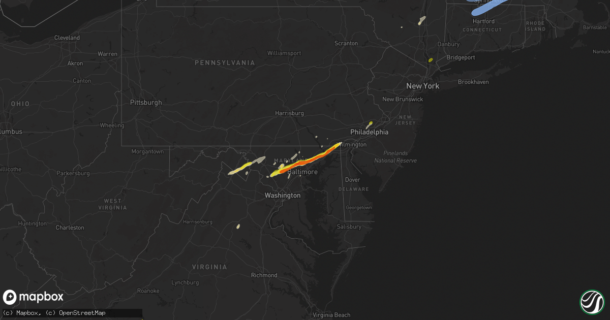
Hail Map on May 3, 2025
Get this storm
May 3 map
$229
one time, instant access
Download today. No call, no setup
Keep the $229
Bought the map and want the full workflow? Apply the entire $229 to a subscription within 7 days. None of it is wasted.
Every map, not just this one
This buys you this map. Subscription and you get every map we run, in the markets you choose from a few cities to whole states to nationwide. Plus real-time alerts the moment a storm fires.
Contact data
Name, contact info, occupancy, even credit band for addresses in the footprint. You go from where it hit to who to call.
Become the source they trust
Unlimited branding weather history reports on demand. You already have the documented answer ready for the property owner, and you are the one who showed up with it.
Property data and RoofTrace estimates
Pull up any address you have got, its value and the exact code rules for that jurisdiction, straight from One Click Code. Then RoofTrace estimates the squares, pitch, and roof value, priced the way you price.
States Impacted by Hail Map on May 3, 2025
Storm reports
South Carolina
| Date | Description |
|---|---|
| 05/03/20255:16 PM CDT | Facebook post with a video of hail falling on low country hwy between olar and ehrhardt. Additional photo showed a hailstone that was approximately quarter size. Time p |
| 05/03/20251:32 PM CDT | Home along lake greenwood near waterloo sustained damage to siding... Patio furniture... Bent flag poles and multiple tree limbs down. |
| 05/03/20253:41 AM CDT | North myrtle beach asos |
| 05/03/20251:24 AM CDT | Social media images showing damage to chicken barns along juniper creek rd off of ehrhardt rd west of govan. Time estimated from radar. |
| 05/03/202512:20 AM CDT | Kershaw county fire reported a few downed trees and a flipped storage shed near boonetown road and old georgetown road. |
| 05/02/20259:53 PM CDT | Power outage due to fallen trees/limbs near junction of lightwood knot rd and cunningham rd. Time estimated from radar. |
| 05/02/20259:28 PM CDT | Severe wind gust observed by nws employee. |
| 05/02/20259:28 PM CDT | Additional details added for previous tstm wnd dmg report from 1 ne mauldin. Severe wind gust observed by nws employee. Patio umbrella tossed and destroyed... Large lim |
| 05/02/20259:22 PM CDT | Power outage attributed to fallen trees/limbs on douglas dr. |
| 05/02/20259:14 PM CDT | Trees down at kennedy dr and daisy dr. |
| 05/02/20258:40 PM CDT | Power outage attributed to fallen trees/limbs near keowee springs golf course. |
| 05/02/20258:37 PM CDT | Power outage along hwy 137 north of six mile attributed to fallen trees/limbs. |
West Virginia
| Date | Description |
|---|---|
| 05/03/20254:22 PM CDT | Tree fell down on a vehicle at the locust hill golf course subdivision causing multiple injuries |
| 05/03/20254:09 PM CDT | Tree down at the intersection of flowings springs rd & old country club rd |
| 05/03/20253:49 PM CDT | A local report indicates 1.25 inch wind near 1 E Martinsburg Arpt |
| 05/03/20253:47 PM CDT | Tree down at the 1100 block of brucetown rd |
Georgia
| Date | Description |
|---|---|
| 05/03/20256:05 PM CDT | Mesonet station cohg1 4 n conasauga lake. |
| 05/03/20255:31 PM CDT | Mesonet station naog1 armuchee. |
| 05/03/20255:10 PM CDT | One large tree down near the intersection of sonya drive and rauschenberg road nw. |
| 05/03/20254:53 PM CDT | Tree down blocking trion teloga road just passed the hawk ridge road intersection. |
| 05/03/20254:47 PM CDT | Tree down blocking both lanes at harrisburg road and olympic lane. |
| 05/03/20254:40 PM CDT | Several trees down on the roads in summerville. |
| 05/03/20254:35 PM CDT | Report of trees down on the roadway at trion teloga rd and bryant rd. |
| 05/02/20259:15 PM CDT | Broadcast media report tree down on powerlines at johnson ln near juliette rd. |
| 05/02/20259:05 PM CDT | Multiple trees down in and near the town of culloden. Preliminary. |
| 05/02/20258:57 PM CDT | Broadcast media reports tree down at old lexington road near crestwood dr in east athens. |
| 05/02/20257:53 PM CDT | Broadcast media report of several down trees and homes missing siding. |
New Jersey
| Date | Description |
|---|---|
| 05/03/20255:58 PM CDT | Report from mping: quarter |
| 05/03/20254:51 PM CDT | Numerous wires down. Time estimated from kdix radar. |
| 05/03/20254:45 PM CDT | Numerous reports of wires down. Time estimated from kdix radar. |
| 05/03/20254:31 PM CDT | Numerous wires down. Time estimated from kdix radar. |
Nevada
| Date | Description |
|---|---|
| 05/03/20255:47 PM CDT | Peak outflow wind gust. Mesonet station mjbn2 majuba. Station elevation: 5292 ft. |
| 05/03/20254:35 PM CDT | Corrects previous tstm wnd gst report from 3 sw mercury. Desert rock asos gusted to 69 mph from a nearby thunderstorm. |
| 05/03/20254:35 PM CDT | Corrects previous tstm wnd gst report from 3 sw mercury. Desert rock asos gusted to 69 mph from a nearby thunderstorm. |
| 05/03/20253:47 PM CDT | Peak outflow wind gust. Mesonet station cyvn2 cherry valley. Station elevation: 7622 ft. |
| 05/03/20251:45 PM CDT | Buster jangle y sensor a01ab measured a gust of 65 mph from a nearby thunderstorm. |
Maryland
| Date | Description |
|---|---|
| 05/03/20255:35 PM CDT | Tree down in providence blocking the roadway. |
| 05/03/20255:34 PM CDT | A local report indicates 1.00 inch wind near 1 NW Fair Hill |
| 05/03/20255:15 PM CDT | A local report indicates 1.50 inch wind near 1 NW Pleasant Hill |
| 05/03/20255:12 PM CDT | A local report indicates 1.00 inch wind near 2 ENE Woodlawn |
| 05/03/20255:10 PM CDT | A local report indicates 1.50 inch wind near Woodlawn |
| 05/03/20254:51 PM CDT | Tree down at gambrill park rd and high knob rd |
| 05/03/20254:51 PM CDT | Tree down at main st and wolfsville rd |
| 05/03/20254:36 PM CDT | A local report indicates 1.25 inch wind near 2 SE Bel Air |
| 05/03/20254:35 PM CDT | A local report indicates 1.50 inch wind near 1 SSE Bel Air |
| 05/03/20254:33 PM CDT | Tree down at the 1700 block of south fountain green rd |
| 05/03/20254:33 PM CDT | Tree down at the 1100 block of mcphail rd |
| 05/03/20254:26 PM CDT | Tree down at the intersection of mt briar rd and marble quarry rd |
| 05/03/20254:26 PM CDT | Tree down at the intersection of laurel bush rd and rt 924 |
| 05/03/20254:22 PM CDT | Tree down at the 1700 block of canal rd |
| 05/03/20254:18 PM CDT | A local report indicates 1.75 inch wind near 1 E Pleasant Hills |
| 05/03/20253:56 PM CDT | A local report indicates 1.75 inch wind near 1 W Timonium |
| 05/03/20253:51 PM CDT | A local report indicates 1.00 inch wind near Owings Mills |
| 05/03/20253:48 PM CDT | A local report indicates 1.00 inch wind near 1 N Mcdonogh |
| 05/03/20253:34 PM CDT | Tree down on a car in the 6700 block of baltimore national pike. |
| 05/03/20253:26 PM CDT | Multiple large tree branches snapped. |
| 05/03/20253:13 PM CDT | A local report indicates 1.50 inch wind near 1 NE Glenwood |
| 05/03/20252:54 PM CDT | Trees and wires down in the 8000 block of rocky road. |
| 05/03/20252:51 PM CDT | A local report indicates 1.00 inch wind near 3 SW Damascus |
Pennsylvania
| Date | Description |
|---|---|
| 05/03/20256:56 PM CDT | Tree down. |
| 05/03/20256:44 PM CDT | Downed tree on rose valley rd / yale av / manchester av southbound between creek rd and school ln. Time estimated from radar. |
| 05/02/20257:27 PM CDT | Multiple trees down in abington township including a tree into a house. Time estimated from radar. |
| 05/02/20257:27 PM CDT | Report from mping: quarter |
Massachusetts
| Date | Description |
|---|---|
| 05/03/20254:30 PM CDT | Tree down on a car on corner of shawsheen and arlington streets in tewksbury. Relayed by amateur radio. |
| 05/03/20254:08 PM CDT | A trained weather spotter reported 2 trees downed on a truck in bolton. Time estimated by radar. No injuries. |
| 05/03/20254:00 PM CDT | Tree and wires downed on damon rd. Relayed by amateur radio. |
| 05/03/20253:55 PM CDT | Worcester regional airport. |
| 05/03/20253:55 PM CDT | Large tree branch reported down on wires on burncoat st in worcester. Time estimated by radar. Relayed via amateur radio. |
| 05/03/20253:53 PM CDT | A local report indicates 60 MPH wind near 1 S Holden |
| 05/03/20253:50 PM CDT | Trees reported down on wires in holden. Time estimated by radar and relayed via amateur radio. |
| 05/03/20253:50 PM CDT | Large tree branch reported down on power lines in worcester. Time estimated by radar. Relayed via amateur radio. |
| 05/03/20253:50 PM CDT | Tree reported down on power lines in worcester. Time estimated by radar. Relayed via amateur radio. |
| 05/03/20253:47 PM CDT | Tree down on wirs near church street. Relayed via amateur radio. |
| 05/03/20253:45 PM CDT | Tree down on turkey hill dr in paxton. Relayed via amateur radio. Time estimated by radar. |
| 05/03/20253:43 PM CDT | Tree down near gould rd. Relayed by amateur radio. |
| 05/03/20253:40 PM CDT | 2 trees downed on scott rd in oakham. Relayed by amateur radio. |
| 05/03/20253:40 PM CDT | Several trees and powerlines downed in town... Including coldbrook rd at old turnpike rd. Relayed by amateur radio. |
| 05/03/20253:40 PM CDT | 2 trees down near scott road. Relayed via amateur radio. |
| 05/03/20253:37 PM CDT | Trees and wires reported down on kennedy rd in west brookfield. Time estimated by radar. Relayed via amateur radio. |
| 05/03/20253:35 PM CDT | Trees and wires reported down on lyons rd in west brookfield. Time estimated by radar. Relayed via amateur radio. |
| 05/03/20253:35 PM CDT | Trees and wires reported down in west brookfield. Time estimated by radar. Relayed via amateur radio. |
| 05/03/20253:33 PM CDT | Roof collapse reported on cherry st in ware. Time estimated by radar. Relayed via amateur radio. |
| 05/03/20253:30 PM CDT | Trees reported down. Time estimated by radar. Relayed via amateur radio. |
| 05/03/20253:30 PM CDT | Wires down on south main st in palmer. Time estimated by radar. Relayed via amateur radio. |
| 05/03/20253:30 PM CDT | Large tree... Wires... And transformer reported down on throndike st at elizabeth st. Time estimated by radar. Relayed via amateur radio. |
| 05/03/20253:27 PM CDT | Telephone pole reported down in the road. Time estimated by radar. Relayed via amateur radio. |
| 05/03/20253:27 PM CDT | Power lines reported down on cars in ware. Time estimated by radar. Relayed via amateur radio. |
| 05/03/20253:25 PM CDT | Trees and wires reported down on a car and shed in palmer. Time estimated by radar. Relayed via amateur radio. |
| 05/03/20253:23 PM CDT | Tree downed on wires near michael sears rd in belchertown. Relayed by amateur radio. |
| 05/03/20253:23 PM CDT | Trees downed on wires on several sections of north liberty st in belchertown. Relayed by amateur radio. |
| 05/03/20253:22 PM CDT | Tree and multiple power lines reported down on mount dumplin rd in palmer. Time estimated by radar. Relayed via amateur radio. |
| 05/03/20253:20 PM CDT | Wires down on beachwood terrace. Relayed via amateur radio. |
| 05/03/20253:20 PM CDT | Utility pole down near fernwood ave. Relayed via amateur radio. |
| 05/03/20253:15 PM CDT | Photos showing a large tree and power lines down across larkspur st in springfield. Relayed via amateur radio. |
| 05/03/20253:15 PM CDT | Pictures show a large tree down on two cars in springfield. Relayed via amateur radio. |
| 05/03/20253:15 PM CDT | Tree down on house near peekskill ave. Relayed by amateur radio. |
| 05/03/20253:15 PM CDT | Large tree blocking delmore street. Report relayed via amateur radio. |
| 05/03/20252:58 PM CDT | Tree down on hastings road. Relayed via amateur radio. |
| 05/03/20252:57 PM CDT | Barnes/westfield airport. |
| 05/03/20252:50 PM CDT | Trees down on powerlines in the area of kelton street. Relayed via amateur radio. |
| 05/03/20252:35 PM CDT | Tree down in area of otter river road blocking southbound lane. Relayed via amateur radio. |
| 05/03/20252:30 PM CDT | Law enforcement reports a tree down on wires blocking river road. |
| 05/03/20252:25 PM CDT | 2 trees down on wires on state road. Relayed via amateur radio. |
| 05/03/20252:25 PM CDT | 2 trees downed on powerline wires on state road in phillipston. Relayed by amateur radio. |
| 05/03/20252:15 PM CDT | Tree and powerline wires downed near chestnut hill rd in montague. Relayed by amateur radio. |
| 05/03/202512:50 PM CDT | Downed trees blocking a roadway in lanesborough. |
| 05/02/20258:25 PM CDT | Tree down on a car occupied by an individual on main st in bolton. Relayed by amateur radio. |
Alabama
| Date | Description |
|---|---|
| 05/03/20256:38 PM CDT | Tree down at buttston rd and germanys ferry rd. |
| 05/03/20256:23 PM CDT | Multiple trees down on davis circle near west lafayette st and pear tree ln. |
| 05/03/20256:04 PM CDT | Tree down at weoka rd and nobles rd. |
| 05/03/20255:24 PM CDT | Trees down on coaling rd in sylacauga and trees and power lines down on canal st in childersburg. |
| 05/03/20255:11 PM CDT | Trees down across possum trot rd and cove rd north of jacksonville and across main st and e 3rd st in oxford. |
| 05/03/20254:50 PM CDT | Photo of nearly half dollar sized hail in fruitdale... Al. Photo via social media. |
| 05/03/20254:31 PM CDT | Several trees down north of gaylesville... Including cr 41 and cr 772... Cr 826... Cr 114... Cr 81 at cr 77... And hwy 35. |
| 05/03/20254:25 PM CDT | A tree was knocked down blocking both lanes about 1/2 mile from cr 30 along cr 82. Time estimated by radar. |
| 05/03/20254:01 PM CDT | A tree was knocked down blocking one lane at 1132 cr 310. |
| 05/03/20253:58 PM CDT | Several trees reported down by ema in the sulpher springs area along hwy 11. |
| 05/03/20253:58 PM CDT | Tree reported down by ema at the alabama welcome center on i-59. |
| 05/03/20253:55 PM CDT | A flag pole and tree were knocked down at the rosalie fire station on highway 71. |
| 05/03/20253:48 PM CDT | Tree limb reported down on a house by ema at 3358 cr 60 in jackson county al. |
| 05/03/20253:48 PM CDT | Tree reported down by ema at till davis road at county road 67 langston... Al. |
| 05/03/20253:48 PM CDT | Tree reported down by ema at 9277 cr 67 langston... Al. |
| 05/03/20253:48 PM CDT | Report of tree down block the road way by ema at county road 82 and county road 30 in scottsboro... Al. |
| 05/03/20253:30 PM CDT | Tree reported down on powerlines by ema at county road 245 at county road 33 hytop al. |
| 05/03/20253:00 PM CDT | Tree reported down over the roadway by ema at 147 county road 10 paint rock... Al. |
Utah
| Date | Description |
|---|---|
| 05/02/202511:45 PM CDT | Mesonet station dpg19 fish springs. |
| 05/02/20259:20 PM CDT | Mesonet station pc476 mineral mountains. |
| 05/02/20257:53 PM CDT | Asos station kbce bryce canyon airport. |
Florida
| Date | Description |
|---|---|
| 05/03/20255:09 PM CDT | Photo of nearly ping pong ball size hail taken near the molino/cantonment fl area. Photo via social media. |
| 05/03/20255:09 PM CDT | Photos of quarter to half dollar sized hail in molino... Fl. Photos via social media. |
Texas
| Date | Description |
|---|---|
| 05/03/20256:42 PM CDT | Report of hail up to quarter size covering the roadway along state highway 17. |
| 05/03/20256:41 PM CDT | A local report indicates 1.00 inch wind near 5 NE Fort Davis |
New York
| Date | Description |
|---|---|
| 05/03/20255:30 PM CDT | Trees and powerlines down. |
| 05/03/20252:02 PM CDT | Tree down across roadway. Time estimated from radar. |
| 05/03/20251:54 PM CDT | Corrects previous tstm wnd dmg report from amenia. Tree down across roadway. Time estimated from radar. |
| 05/03/20251:28 PM CDT | Trees and wires down on wildwood drive. |
| 05/03/202512:54 PM CDT | Tree down across roadway. Time estimated from radar. |
| 05/03/202512:53 PM CDT | Tree and wires down on halihan hill road. |
| 05/03/202512:46 PM CDT | Multiple trees and powerlines down. |
| 05/03/202512:08 PM CDT | Image shows hail approximately quarter sized in coxsackie. Time estimated from radar. |
New Hampshire
| Date | Description |
|---|---|
| 05/03/20253:09 PM CDT | Reported by amateur radio... Time estimated by radar. |
| 05/03/20253:08 PM CDT | Reported by amateur radio... Time estimated by radar. |
| 05/03/20252:40 PM CDT | Reported by weather spotter... Time estimated by radar. |
| 05/03/20252:40 PM CDT | Measured off of kestrel. Time estimated by radar. |
| 05/03/20252:39 PM CDT | Reported by amateur radio... Multiple 10-12 inch diameter trees down on nason rd. Time estimated by radar. |
| 05/03/20252:35 PM CDT | Reported by weather spotter... Time estimated by radar. |
| 05/03/20251:20 PM CDT | Reported by weather spotter... Time estimated by radar. |
| 05/03/20251:16 PM CDT | Large pine tree blocking one lane on nh rt 101. Additional estimated 15 to 20 trees down off the side of nh rt 101. Time estimated by radar. |
| 05/03/20251:15 PM CDT | Corrects previous tstm wnd dmg report from 2 nw hampton falls. Reported by amateur radio... Multiple 10-12 inch diameter trees down on nason rd. Time estimated by radar |
| 05/03/20251:08 PM CDT | Reported by amateur radio... Time estimated by radar. |
Connecticut
| Date | Description |
|---|---|
| 05/03/20255:43 PM CDT | Tree limbs and powerlines down. |
| 05/03/20253:10 PM CDT | Tree down on holcomb streeet at barndoor hill road. Relayed by amateur radio. |
| 05/03/20253:10 PM CDT | Tree down on a car near hatchet hill road. |
| 05/03/20253:10 PM CDT | Multiple trees down on power lines on buttles road. Relayed via amateur radio. |
| 05/03/20252:56 PM CDT | Bradley intl airport. |
| 05/03/20252:49 PM CDT | Trees downed at ct route 181 and goose green road. |
| 05/03/20252:45 PM CDT | Trees downed on route 202 at east cotton hill road. |
| 05/03/20252:45 PM CDT | Trees downed on maple hollow road. |
| 05/03/20252:45 PM CDT | Trees downed on route 44. |
| 05/03/20252:34 PM CDT | Wires downed. |
| 05/03/20252:25 PM CDT | Trees downed on route 4 just west of goshen. |
| 05/03/20252:13 PM CDT | Multiple downed trees blocking a roadway. |
Virginia
| Date | Description |
|---|---|
| 05/03/20254:21 PM CDT | Thunderstorm winds blew down one tree along the 3300 block of brookside road close to the intersection with medical center road. |
| 05/03/20254:04 PM CDT | Tree down at the intersection of leeds manor rd & crest hill rd |
| 05/03/20253:10 PM CDT | Tree down along seminole drive. |
| 05/03/20253:06 PM CDT | Tree down blocking the road at the intersection of hidden valley drive and c c lane in martinsville virginia. |
| 05/03/20252:51 PM CDT | Tree down on redd level plant road. |
| 05/03/20252:31 PM CDT | Thunderstorm winds blew down one power line near the intersection of dry pond highway and creasy chapel road. |
| 05/03/20252:16 PM CDT | Tree down on gleedsville road at emerald park drive. |
North Carolina
| Date | Description |
|---|---|
| 05/03/20254:20 PM CDT | Trees down at tennessee st and pennsylvania ave. |
| 05/03/20254:15 PM CDT | Tree down on utility equipment. |
| 05/03/20253:54 PM CDT | Trees down on utility equipment. |
| 05/03/20253:44 PM CDT | Tree down on utility equipment. |
| 05/03/20253:35 PM CDT | Thunderstorm winds blew down one tree near the 200 block of bald hill loop just south of highway 704. |
| 05/03/20252:35 PM CDT | Thunderstorm winds blew down several trees near the intersection of highway 65 and easley road. |
| 05/03/20252:15 PM CDT | Two trees down at old beatty ford rd and emmanuel church rd. |
| 05/03/20253:58 AM CDT | Corrects previous tstm wnd dmg report from 4 sw four oaks. Multiple trees snapped off and a large tree uprooted in the 2400 block of parkertown rd. Corrected for time. |
| 05/03/20252:58 AM CDT | Multiple trees snapped off and a large tree uprooted in the 2400 block of parkertown rd. |
| 05/03/202512:33 AM CDT | Power outage attributed to fallen trees/limbs around long bow rd. Time estimated from radar. |
| 05/03/202512:05 AM CDT | Large tree blocking roadway...shiloh rd at doodle dr. Time estimated from radar and obs. |
| 05/03/202512:00 AM CDT | Power outage attributed to fallen trees/limbs between univ city blvd and e wt harris blvd. |
| 05/03/202512:00 AM CDT | Trees down near junction of cattlemans rd and mtn view rd. Time estimated. |
| 05/02/202510:21 PM CDT | Trees down at youngblood rd and mckee rd... And west to catawba river on adjacent roadways. |
Cities Impacted by Hail Map on May 3, 2025
- Earlton, NY
- Climax, NY
- West Coxsackie, NY
- Coxsackie, NY
- Stuyvesant, NY
- Valatie, NY
- Old Chatham, NY
- Wurtsboro, NY
- Hodges, SC
- Abbeville, SC
- Greenwood, SC
- Highland, NY
- New Paltz, NY
- Clintondale, NY
- Waterloo, SC
- Ulster Park, NY
- Ridgeway, SC
- Bassett, VA
- Patrick Springs, VA
- Heath Springs, SC
- Locust, NC
- Midland, NC
- Mount Pleasant, NC
- Erving, MA
- Lake Pleasant, MA
- Montague, MA
- Millers Falls, MA
- Turners Falls, MA
- Deerfield, MA
- Gill, MA
- Northfield, MA
- South Deerfield, MA
- Buffalo, SC
- Union, SC
- Enoree, SC
- Leverett, MA
- Sunderland, MA
- Thomasville, NC
- Germantown, MD
- Boyds, MD
- Damascus, MD
- Gaithersburg, MD
- Clarksburg, MD
- Winnsboro, SC
- Peterborough, NH
- Jaffrey, NH
- Rindge, NH
- Fitzwilliam, NH
- Dublin, NH
- Temple, NH
- Greenfield, NH
- Lyndeborough, NH
- Huntington, MA
- Otis, MA
- Westfield, MA
- Blandford, MA
- East Otis, MA
- Russell, MA
- Granville, MA
- Easthampton, MA
- Southampton, MA
- Southwick, MA
- Brookeville, MD
- Woodbine, MD
- Exeter, NH
- Hampton Falls, NH
- Hampton, NH
- Mount Airy, MD
- Cooksville, MD
- Glenwood, MD
- Rye, NH
- Rye Beach, NH
- North Hampton, NH
- Ludowici, GA
- West Springfield, MA
- South Hadley, MA
- Northampton, MA
- Hadley, MA
- Amherst, MA
- Holyoke, MA
- Ludlow, MA
- Chicopee, MA
- Granby, MA
- Montgomery Village, MD
- Sykesville, MD
- Glenelg, MD
- West Friendship, MD
- Catawba, SC
- Rock Hill, SC
- Fernandina Beach, FL
- Marriottsville, MD
- Winchester, VA
- Belchertown, MA
- Ware, MA
- Three Rivers, MA
- Wilbraham, MA
- Springfield, MA
- Indian Orchard, MA
- Palmer, MA
- West Brookfield, MA
- Bondsville, MA
- North Brookfield, MA
- Thorndike, MA
- West Warren, MA
- Warren, MA
- Gilbertville, MA
- Hardwick, MA
- New Braintree, MA
- Woodstock, MD
- Ellicott City, MD
- Randallstown, MD
- Owings Mills, MD
- Pikesville, MD
- Stevenson, MD
- Hollis, NH
- Dickerson, MD
- Bunker Hill, WV
- Brookline, NH
- Clear Brook, VA
- Yulee, FL
- Windsor Mill, MD
- Nashua, NH
- Greenville, NH
- Milford, NH
- Amherst, NH
- Merrimack, NH
- West Granby, CT
- West Simsbury, CT
- Canton, CT
- Barkhamsted, CT
- Simsbury, CT
- Granby, CT
- New Hartford, CT
- Longmeadow, MA
- West Suffield, CT
- Bloomfield, CT
- North Granby, CT
- East Granby, CT
- Suffield, CT
- Tariffville, CT
- Agawam, MA
- Windsor Locks, CT
- Windsor, CT
- East Windsor, CT
- Enfield, CT
- Monson, MA
- Somers, CT
- East Longmeadow, MA
- Hampden, MA
- Brimfield, MA
- Stafford Springs, CT
- Wales, MA
- Lutherville Timonium, MD
- Cockeysville, MD
- Towson, MD
- Parkville, MD
- Glen Arm, MD
- Phoenix, MD
- Marion, AL
- Kearneysville, WV
- Inwood, WV
- Stephenson, VA
- Westminster, MA
- South Barre, MA
- Barre, MA
- Hubbardston, MA
- Oakham, MA
- Rutland, MA
- North Oxford, MA
- Auburn, MA
- Charlton, MA
- Sturbridge, MA
- East Brookfield, MA
- Fiskdale, MA
- Leicester, MA
- Brookfield, MA
- Rochdale, MA
- Spencer, MA
- Millbury, MA
- Oxford, MA
- Holland, MA
- Sutton, MA
- Southbridge, MA
- Paxton, MA
- Princeton, MA
- Jefferson, MA
- Holden, MA
- Cherry Valley, MA
- Worcester, MA
- West Boylston, MA
- Fork, MD
- Fallston, MD
- Kingsville, MD
- Baldwin, MD
- Hydes, MD
- Martinsburg, WV
- Shenandoah Junction, WV
- Shepherdstown, WV
- Richton, MS
- Jesup, GA
- Kingston, NH
- East Kingston, NH
- Epping, NH
- Centreville, AL
- Charles Town, WV
- Ranson, WV
- Baltimore, MD
- State Line, MS
- Hudson, MA
- Northborough, MA
- Bolton, MA
- Berlin, MA
- North Grafton, MA
- Lancaster, MA
- Boylston, MA
- Leominster, MA
- Westborough, MA
- Marlborough, MA
- Shrewsbury, MA
- Clinton, MA
- Southborough, MA
- Sterling, MA
- Grafton, MA
- Shirley, MA
- Lunenburg, MA
- Groton, MA
- Fitchburg, MA
- Ayer, MA
- Boxborough, MA
- Stow, MA
- Harvard, MA
- Devens, MA
- Bel Air, MD
- Joppa, MD
- Sharpsburg, MD
- Keedysville, MD
- Harpers Ferry, WV
- Sudbury, MA
- Concord, MA
- Acton, MA
- Maynard, MA
- Chelmsford, MA
- Billerica, MA
- Carlisle, MA
- Westford, MA
- Littleton, MA
- Bedford, MA
- North Billerica, MA
- Lincoln, MA
- Framingham, MA
- Wayland, MA
- Lexington, MA
- Hanscom Afb, MA
- Burlington, MA
- Abingdon, MD
- Churchville, MD
- Aberdeen, MD
- Fruitdale, AL
- Plantersville, AL
- Maplesville, AL
- Tewksbury, MA
- Boxford, MA
- North Andover, MA
- Andover, MA
- Wilmington, MA
- North Reading, MA
- Lynnfield, MA
- Reading, MA
- Woburn, MA
- Middleton, MA
- Topsfield, MA
- Havre De Grace, MD
- Ipswich, MA
- Rowley, MA
- Georgetown, MA
- Fairfax, SC
- Deer Park, AL
- Billingsley, AL
- Tibbie, AL
- Middletown, MD
- Myersville, MD
- Rohrersville, MD
- Boonsboro, MD
- Port Deposit, MD
- Perryville, MD
- Chatom, AL
- Rising Sun, MD
- Fort Davis, TX
- Cantonment, FL
- Molino, FL
- Robertsdale, AL
- Eastaboga, AL
- Anniston, AL
- Lincoln, AL
- Brunson, SC
- Verbena, AL
- Marbury, AL
- Frederick, MD
- Thurmont, MD
- Pleasantville, NY
- Briarcliff Manor, NY
- Tarrytown, NY
- Chappaqua, NY
- North East, MD
- Elkton, MD
- Olar, SC
- Bamberg, SC
- Ulmer, SC
- Rockford, AL
- Ehrhardt, SC
- Sumter, SC
- Wedgefield, SC
- Rembert, SC
- Dalzell, SC
- Clanton, AL
- Safford, AL
- Lincoln University, PA
- Oxford, PA
- Landenberg, PA
- Catherine, AL
- Jones, AL
- New Market, MD
- Prattville, AL
- Deatsville, AL
- Titus, AL
- Vinegar Bend, AL
- Selma, AL
- Milton, FL
- Orrville, AL
- Autaugaville, AL
- Mitchells, VA
- Rapidan, VA
- Citronelle, AL
- Equality, AL
- Alexander City, AL
- Jacksons Gap, AL
- Dadeville, AL
- Sardis, AL
- Culpeper, VA
- Minter, AL
- Reisterstown, MD
- Tyler, AL
- Finksburg, MD
- Pylesville, MD
- Upperco, MD
- Sparks Glencoe, MD
- Parkton, MD
- Linthicum Heights, MD
- Hayneville, AL
- Clarksville, MD
- Columbia, MD
- Fulton, MD
- Holtwood, PA
- Pequea, PA
- Philadelphia, PA
- Fayetteville, GA
- Opelika, AL
- Salem, AL
- White Hall, MD
- Jonesboro, GA
- Hampton, GA
- Elkins Park, PA
- Jenkintown, PA
- Wyncote, PA
- Perry Hall, MD
- Stockbridge, GA
- Huntingdon Valley, PA
- Glenside, PA
- Abington, PA
- Mcdonough, GA
- Pine Mountain Valley, GA
- Bala Cynwyd, PA
- Peach Bottom, PA
- Conowingo, MD
- Woodland, GA
- Shiloh, GA
- Hamilton, GA
- Kirkwood, PA
- Newton, NH
- East Hampstead, NH
- Stratham, NH
- Greenland, NH
- Portsmouth, NH
- Darlington, MD
- La Mesa, NM
- Anthony, NM
- Anthony, TX
- Greenville, FL
- Perry, FL
- Hannacroix, NY
- Athens, NY
- Kinderhook, NY
- Madison, FL
- Lee, FL
- Weatogue, CT
- Etlan, VA
- North Myrtle Beach, SC
- Longs, SC
- Little River, SC
- Myrtle Beach, SC
- Calabash, NC
- Sunset Beach, NC