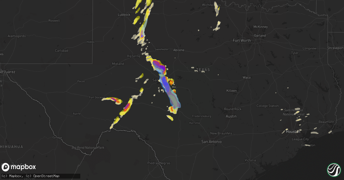
Hail Map in Texas on May 3, 2024
Get this storm
May 3 map
$229
one time, instant access
Download today. No call, no setup
Keep the $229
Bought the map and want the full workflow? Apply the entire $229 to a subscription within 7 days. None of it is wasted.
Every map, not just this one
This buys you this map. Subscription and you get every map we run, in the markets you choose from a few cities to whole states to nationwide. Plus real-time alerts the moment a storm fires.
Contact data
Name, contact info, occupancy, even credit band for addresses in the footprint. You go from where it hit to who to call.
Become the source they trust
Unlimited branding weather history reports on demand. You already have the documented answer ready for the property owner, and you are the one who showed up with it.
Property data and RoofTrace estimates
Pull up any address you have got, its value and the exact code rules for that jurisdiction, straight from One Click Code. Then RoofTrace estimates the squares, pitch, and roof value, priced the way you price.
Storm reports in Texas
Texas
| Date | Description |
|---|---|
| 05/03/20246:48 PM CDT | Ping pong ball size hail found on the side of the road between matador and whiteflat. Time estimated from radar. |
| 05/03/20246:48 PM CDT | Remote area southwest of eden. |
| 05/03/20246:43 PM CDT | Report from mping: golf ball |
| 05/03/20246:39 PM CDT | Report from mping: grapefruit |
| 05/03/20246:37 PM CDT | Report from mping: baseball+ |
| 05/03/20246:35 PM CDT | Called in quarter sized hail. |
| 05/03/20246:31 PM CDT | West texas mesonet site at fort lancaster. |
| 05/03/20246:27 PM CDT | A local report indicates 1.00 inch wind near 2 ENE Wall |
| 05/03/20246:26 PM CDT | A local report indicates 59 MPH wind near 2 SSE San Angelo |
| 05/03/20246:19 PM CDT | Hail report from 7849 ripple rd off of hwy 87. |
| 05/03/20246:18 PM CDT | Trees and fences damaged. Minor cosmetic damage reported to houses in the area. |
| 05/03/20246:18 PM CDT | A local report indicates 2.75 inch wind near Wall |
| 05/03/20246:17 PM CDT | A local report indicates 2.50 inch wind near 2 WNW Wall |
| 05/03/20246:17 PM CDT | West texas mesonet site. |
| 05/03/20246:10 PM CDT | A local report indicates 1.75 inch wind near 4 ENE San Angelo |
| 05/03/20246:07 PM CDT | Baseball size hail and hail damage reported near fm 308 near the concho river. |
| 05/03/20246:04 PM CDT | Brief tornado. |
| 05/03/20245:57 PM CDT | A local report indicates 1.75 inch wind near 6 W Harriet |
| 05/03/20245:29 PM CDT | A local report indicates 2.00 inch wind near Dickens |
| 05/03/20245:24 PM CDT | A local report indicates 1.75 inch wind near 4 NNW Orient |
| 05/03/20245:08 PM CDT | West texas mesonet site. |
| 05/03/20245:02 PM CDT | A local report indicates 2.75 inch wind near 7 SSW Bronte |
| 05/03/20244:53 PM CDT | Very large tornado. |
| 05/03/20244:40 PM CDT | A local report indicates 1.75 inch wind near 10 S Silver |
| 05/03/20244:33 PM CDT | Brief tornado touchdown north-northeast of hale center. |
| 05/03/20244:12 PM CDT | Several golf ball sized hailstones observed falling on live webcam. |
| 05/03/20243:45 PM CDT | A local report indicates 2.75 inch wind near Fluvanna |
| 05/03/20243:45 PM CDT | A local report indicates 2.00 inch wind near 3 W Fluvanna |
| 05/03/20243:45 PM CDT | A local report indicates a tornado near 6 SSW Silver |
| 05/03/20243:45 PM CDT | A local report indicates 59 MPH wind near 3 WNW Fluvanna |
| 05/02/202410:24 PM CDT | This wind gust occurred under a thunderstorm anvil... And was not caused by a notable thunderstorm on radar. |
| 05/02/20249:40 PM CDT | Social media report. |
| 05/02/20249:23 PM CDT | A local report indicates 1.50 inch wind near Miami |
| 05/02/20249:03 PM CDT | Social media report of golf ball to tennis ball sized hail just south of cleo. |
| 05/02/20247:44 PM CDT | A local report indicates 1.75 inch wind near 6 NNW Boys Ranch |
| 05/02/20247:33 PM CDT | West texas mesonet site. |
| 05/02/20247:26 PM CDT | Quitaque vfd reports hailstones ranging from 2.25 to 3.5 inches in diameter. |
| 05/02/20247:18 PM CDT | Snapped power poles along fm2393. Radar estimated time. |
| 05/02/20247:12 PM CDT | Report from mping: quarter |
All States Impacted by Hail Map on May 3, 2024
Cities Impacted by Hail Map on May 3, 2024
- Port Arthur, TX
- Anahuac, TX
- Hockley, TX
- Cameron, LA
- Galena Park, TX
- Houston, TX
- Channelview, TX
- Pasadena, TX
- Lovelady, TX
- Crockett, TX
- Cleveland, TX
- Coldspring, TX
- Conroe, TX
- Anderson, TX
- Montgomery, TX
- Richards, TX
- Katy, TX
- Richmond, TX
- Willis, TX
- Winnie, TX
- Crosby, TX
- Beaumont, TX
- New Caney, TX
- Splendora, TX
- Porter, TX
- Broadwater, NE
- Bridgeport, NE
- Huffman, TX
- Magnolia, TX
- Dayton, TX
- Westbrook, TX
- Oshkosh, NE
- Ball Ground, GA
- Normangee, TX
- Colorado City, TX
- Ellsworth, NE
- Columbus, MS
- Baytown, TX
- Highlands, TX
- Franklin, TX
- West Point, MS
- Loraine, TX
- Springer, NM
- Ira, TX
- Snyder, TX
- Fluvanna, TX
- Las Animas, CO
- Maryneal, TX
- Robert Lee, TX
- San Angelo, TX
- Miles, TX
- Justiceburg, TX
- La Porte, TX
- Deer Park, TX
- Blackwell, TX
- Chappell, NE
- Hale Center, TX
- Kress, TX
- Gail, TX
- Shepherd, TX
- Post, TX
- New Market, AL
- Bronte, TX
- Plainview, TX
- Wiley, CO
- Reform, AL
- Hasty, CO
- McClave, CO
- Braselton, GA
- Happy, TX
- Eads, CO
- Adrian, TX
- Hoschton, GA
- Grenville, NM
- Fort Stockton, TX
- Jefferson, GA
- Pendergrass, GA
- Lamar, CO
- Sheridan Lake, CO
- Norton, TX
- Ballinger, TX
- Dryden, TX
- Spur, TX
- Paint Rock, TX
- Eola, TX
- Vega, TX
- Crosbyton, TX
- Mereta, TX
- Dickens, TX
- Ogallala, NE
- Grant, NE
- Lorenzo, TX
- Ralls, TX
- Mcadoo, TX
- Hartley, TX
- Channing, TX
- Madrid, NE
- Paxton, NE
- Elsie, NE
- Clayton, NM
- Afton, TX
- Iraan, TX
- Ozona, TX
- Menard, TX
- Goodfellow Afb, TX
- Syracuse, KS
- Holly, CO
- Wauneta, NE
- Floydada, TX
- Wall, TX
- Eden, TX
- Vancourt, TX
- Wallace, NE
- Roaring Springs, TX
- Tribune, KS
- Woodson, TX
- Hayes Center, NE
- Wray, CO
- Haigler, NE
- Henrietta, TX
- Ovalo, TX
- Walsh, CO
- Dickens, NE
- Matador, TX
- Benkelman, NE
- Hershey, NE
- Manter, KS
- Sheffield, TX
- Graham, TX
- Wellfleet, NE
- Eldorado, TX
- Lockney, TX
- Jacksboro, TX
- Maywood, NE
- North Platte, NE
- Bryson, TX
- Palisade, NE
- Maxwell, NE
- Sutherland, NE
- Leoti, KS
- Genoa, CO
- Hugo, CO
- Kendall, KS
- Wichita Falls, TX
- Arriba, CO
- Flomot, TX
- Turkey, TX
- Moorefield, NE
- Curtis, NE
- Brady, NE
- Quitaque, TX
- Bridgewater, VA
- McCook, NE
- Lakin, KS
- Santa Anna, TX
- Coleman, TX
- Stockville, NE
- Barnhart, TX
- Brownwood, TX
- Christoval, TX
- Flagler, CO
- Kit Carson, CO
- Saint Francis, KS
- Bird City, KS
- McDonald, KS
- Stratton, NE
- Max, NE
- Mertzon, TX
- Fort McKavett, TX
- Cozad, NE
- Eustis, NE
- Farnam, NE
- Gothenburg, NE
- Deerfield, KS
- Sterling City, TX
- Cambridge, NE
- Bartley, NE
- Indianola, NE
- Culbertson, NE
- Trenton, NE
- Colby, KS
- Atwood, KS
- Elwood, NE
- Early, TX
- Zephyr, TX
- Marienthal, KS
- Edson, KS
- Junction, TX
- Blanket, TX
- Geronimo, OK
- Walters, OK
- Big Lake, TX
- Pampa, TX
- Miami, TX
- Seibert, CO
- Vona, CO
- Cheyenne Wells, CO
- Stratton, CO
- Arapahoe, CO
- Liberal, KS
- Hugoton, KS
- Smithfield, NE
- Bertrand, NE
- Garden City, KS
- Lawton, OK
- Holcomb, KS
- Edison, NE
- Arapahoe, NE
- Lebanon, NE
- London, TX
- Hamilton, TX
- Kismet, KS
- Plains, KS
- Satanta, KS
- Meade, KS
- Sublette, KS
- Fowler, KS
- Scott City, KS
- Levant, KS
- Gem, KS
- Ludell, KS
- Herndon, KS
- Oberlin, KS
- Danbury, NE
- Wilsonville, NE
- Oxford, NE
- Holbrook, NE
- Holdrege, NE
- Orleans, NE
- Loomis, NE
- Atlanta, NE
- Overton, NE
- Canadian, TX
- Higgins, TX
- Skellytown, TX
- Summertown, TN
- Hohenwald, TN
- Elgin, OK
- Elm Creek, NE
- Axtell, NE
- Funk, NE
- Minden, NE
- Miller, NE
- Lexington, NE
- Wakeeney, KS
- Collyer, KS
- Hampshire, TN
- Ingalls, KS
- Hendley, NE
- Anadarko, OK
- Fort Cobb, OK
- Carnegie, OK
- Fletcher, OK
- Cyril, OK
- Borger, TX
- Sonora, TX
- Cement, OK
- Apache, OK
- Roosevelt, TX
- Chickasha, OK
- Verden, OK
- Gracemont, OK
- Cimarron, KS
- Alma, NE
- Amber, OK
- Wilcox, NE
- Beaver City, NE
- Republican City, NE
- Hildreth, NE
- Norton, KS
- Minneola, KS
- Montezuma, KS
- Ensign, KS
- Naponee, NE
- Bloomington, NE
- Heartwell, NE
- Gate, OK
- Binger, OK
- Dighton, KS
- Pocasset, OK
- Minco, OK
- Kearney, NE
- Arnett, OK
- Ninnekah, OK
- Franklin, NE
- Upland, NE
- Campbell, NE
- Riverton, NE
- Smith Center, KS
- Kensington, KS
- Rocksprings, TX
- Woodward, OK
- Briscoe, TX
- Buffalo, OK
- Holstein, NE
- Durham, OK
- Inavale, NE
- Bladen, NE
- Kenesaw, NE
- Roseland, NE
- Blue Hill, NE
- Ethelsville, AL
- Mooreland, OK
- Red Cloud, NE
- Sharon, OK
- Ayr, NE
- Hastings, NE
- Glenvil, NE
- Superior, NE
- Newcastle, TX
- Freedom, OK
- Waynoka, OK
- Taloga, OK
- Seiling, OK
- Lawrence, NE
- Nelson, NE
- Guide Rock, NE
- Camargo, OK
- Trumbull, NE
- Doniphan, NE
- Phillips, NE
- Giltner, NE
- Grand Island, NE
- Inland, NE
- Fairfield, NE
- Deweese, NE
- Harvard, NE
- Clay Center, NE
- Edgar, NE
- Davenport, NE
- Oak, NE
- Ruskin, NE
- Aurora, NE
- Chapman, NE
- Ong, NE
- Saronville, NE
- Marquette, NE
- Sutton, NE
- Hampton, NE
- Deshler, NE
- Hebron, NE
- Henderson, NE
- Shickley, NE
- Carleton, NE
- Geneva, NE
- Grafton, NE
- Bruning, NE
- Belvidere, NE
- Strang, NE
- Fairmont, NE
- McCool Junction, NE
- Alexandria, NE
- Ohiowa, NE
- Milligan, NE
- Tobias, NE
- York, NE
- Bradshaw, NE
- Cheyenne, OK
- Chester, OK
- Alva, OK
- Fairview, OK
- Sweetwater, OK
- Central City, NE
- Alda, NE
- Exeter, NE
- Portis, KS
- Hardtner, KS
- Helena, OK
- Hammon, OK
- Medicine Lodge, KS
- Kiowa, KS
- Glen Elder, KS
- Downs, KS
- Gaylord, KS
- Elk City, OK
- Esbon, KS
- Attica, KS
- Aline, OK
- Lake City, KS
- Dacoma, OK
- Butler, OK
- Carmen, OK
- Cherokee, OK
- Western, NE
- Daykin, NE
- Fairbury, NE
- Friend, NE
- Swanton, NE
- Wilber, NE
- Dorchester, NE
- Burlington, OK
- Jet, OK
- Mankato, KS
- Harper, KS
- Manchester, OK
- Waldron, KS
- Hazelton, KS
- Chester, NE
- Beloit, KS
- Crete, NE
- Hallam, NE
- Clatonia, NE
- Wakita, OK
- Anthony, KS
- Bluff City, KS
- Plymouth, NE
- Freeport, KS
- Boise City, OK
- De Witt, NE
- Argonia, KS
- Danville, KS
- Caldwell, KS
- Milton, KS
- Norwich, KS
- Firth, NE
- Martell, NE
- Cortland, NE
- Pickrell, NE
- Conway Springs, KS
- Medford, OK
- Adams, NE
- Haven, KS
- Burrton, KS
- Concordia, KS
- Glasco, KS
- Hickman, NE
- Douglas, NE
- Aurora, KS
- Geuda Springs, KS
- South Haven, KS
- Newkirk, OK
- Clyde, KS
- Miltonvale, KS
- Arkansas City, KS
- Alberta, AL
- Carrollton, AL
- Hillsboro, KS
- Dunbar, NE
- Nebraska City, NE
- Pawhuska, OK
- Shidler, OK
- Randolph, KS
- Talmage, NE
- Chapman, KS
- Junction City, KS
- Waterville, KS
- Hope, KS
- Barnes, KS
- Green, KS
- Galveston, TX
- Greenleaf, KS
- Rosston, OK
- Ashland, KS
- Laverne, OK
- Riley, KS
- Fairfax, OK
- Burbank, OK
- Fort Riley, KS
- Sedan, KS
- Cedar Vale, KS
- Olsburg, KS
- Manhattan, KS
- Ogden, KS
- Frankfort, KS
- Westmoreland, KS
- Saint George, KS
- Wamego, KS
- Mounds, OK
- Beggs, OK
- Okmulgee, OK
- Belvue, KS
- Onaga, KS
- Havensville, KS
- Emmett, KS
- Saint Marys, KS
- Haskell, OK
- Bixby, OK
- Mayetta, KS
- Delia, KS
- Thayer, KS
- Silver Lake, KS
- Rossville, KS
- Soldier, KS
- Circleville, KS
- Parsons, KS
- Redbird, OK
- Porter, OK
- Holton, KS
- Coweta, OK
- Horton, KS
- Galesburg, KS
- Everest, KS
- Muscotah, KS
- Troy, KS
- Savannah, MO
- Amazonia, MO
- Saint Joseph, MO
- Sulphur Springs, AR
- Osborn, MO
- Cameron, MO
- Centerview, MO
- Jasper, MO
- Golden City, MO


