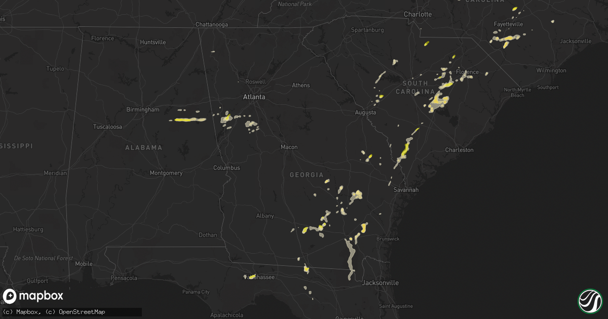
Hail Map in Georgia on May 3, 2022
Get this storm
May 3 map
$229
one time, instant access
Download today. No call, no setup
Keep the $229
Bought the map and want the full workflow? Apply the entire $229 to a subscription within 7 days. None of it is wasted.
Every map, not just this one
This buys you this map. Subscription and you get every map we run, in the markets you choose from a few cities to whole states to nationwide. Plus real-time alerts the moment a storm fires.
Contact data
Name, contact info, occupancy, even credit band for addresses in the footprint. You go from where it hit to who to call.
Become the source they trust
Unlimited branding weather history reports on demand. You already have the documented answer ready for the property owner, and you are the one who showed up with it.
Property data and RoofTrace estimates
Pull up any address you have got, its value and the exact code rules for that jurisdiction, straight from One Click Code. Then RoofTrace estimates the squares, pitch, and roof value, priced the way you price.
Storm reports in Georgia
Georgia
| Date | Description |
|---|---|
| 05/03/20226:26 PM CDT | Large tree limbs down on roadway. |
| 05/03/20225:30 PM CDT | 1.5 hour delayed report. Size estimated from photo on twitter. |
| 05/03/20223:20 PM CDT | A member of the public reported penny to half dollar-size hail near the intersection of main st and mitchell st. |
| 05/03/20222:33 PM CDT | A 911 call center reported a downed tree along mendes road. |
| 05/03/20225:35 AM CDT | At 1033 PM EDT, a severe thunderstorm was located 9 miles northwest of Ducktown, moving east at 35 mph. HAZARD...60 mph wind gusts and quarter size hail. SOURCE...Radar indicated. IMPACT...Hail damage to vehicles is expected. Expect wind damage to roofs, siding, and trees. Locations impacted include... Andrews, Murphy, Ducktown, Hayesville, William L. Davenport Refuge, Tusquitee, Coker Creek, Violet, Big Frog Mountain and Turtletown. |
| 05/03/20222:17 AM CDT | At 717 PM EDT, a severe thunderstorm was located near Pearson, moving south at 15 mph. HAZARD...Golf ball size hail and 60 mph wind gusts. SOURCE...Radar indicated. IMPACT...People and animals outdoors will be injured. Expect hail damage to roofs, siding, windows, and vehicles. Expect wind damage to roofs, siding, and trees. Locations impacted include... Pearson, Willacoochee and Axson. |
| 05/03/20222:13 AM CDT | At 713 PM EDT, a severe thunderstorm was located near Raybon, or near Nahunta, moving south at 15 mph. HAZARD...Golf ball size hail and 60 mph wind gusts. SOURCE...Radar indicated. IMPACT...People and animals outdoors will be injured. Expect hail damage to roofs, siding, windows, and vehicles. Expect wind damage to roofs, siding, and trees. Locations impacted include... Nahunta, Hickox, Braganza, Raybon, Race Pond, Fort Mudge, Atkinson, Hortense and Winokur. |
| 05/03/20221:47 AM CDT | At 647 PM EDT, a severe thunderstorm was located near Omega, or 11 miles south of Tifton, moving east at 10 mph. HAZARD...60 mph wind gusts and quarter size hail. SOURCE...Radar indicated. IMPACT...Hail damage to vehicles is expected. Expect wind damage to roofs, siding, and trees. Locations impacted include... Nashville, Adel, Sparks, Enigma, Omega, Lenox, Alapaha, Ellenton, Reed Bingham State Park, Eldorado, Massee, Glory, Flat Ford, Wagon Wheel, Weber, Cottle, Cook Co A/P, Cool Spring, Staunton and Berrien Co A/P. |
| 05/03/20221:44 AM CDT | At 644 PM EDT, a severe thunderstorm was located 7 miles north of Raybon, or 10 miles east of Patterson, moving east at 10 mph. HAZARD...60 mph wind gusts and quarter size hail. SOURCE...Radar indicated. IMPACT...Hail damage to vehicles is expected. Expect wind damage to roofs, siding, and trees. Locations impacted include... Nahunta, Patterson, Screven, Offerman, Raybon, Waynesville, Atkinson, Mount Pleasant, Hortense and Broadhurst. |
| 05/03/20221:35 AM CDT | At 635 PM EDT, a severe thunderstorm was located near Pearson, moving northeast at 10 mph. HAZARD...Golf ball size hail and 60 mph wind gusts. SOURCE...Radar indicated. IMPACT...People and animals outdoors will be injured. Expect hail damage to roofs, siding, windows, and vehicles. Expect wind damage to roofs, siding, and trees. Locations impacted include... Douglas, Pearson, Willacoochee, Millwood, Bickley and Axson. |
| 05/03/20221:02 AM CDT | At 602 PM EDT, a severe thunderstorm was located over Scotia, moving northeast at 25 mph. HAZARD...60 mph wind gusts and quarter size hail. SOURCE...Radar indicated. IMPACT...Minor hail damage to vehicles is possible. Expect wind damage to trees and powerlines. Locations impacted include: Springfield, Hampton, Yemassee, Lake Warren State Park, Varnville, Estill, Gifford, Furman, Scotia, Luray, Tarboro, Miley, Grays, Shirley and Early Branch.This warning includes I-95 in South Carolina between mile markers 35and 41. |
| 05/03/20221:01 AM CDT | At 601 PM EDT, a severe thunderstorm was located near Douglas, moving east at 15 mph. HAZARD...60 mph wind gusts and quarter size hail. SOURCE...Radar indicated. IMPACT...Hail damage to vehicles is expected. Expect wind damage to roofs, siding, and trees. Locations impacted include... Douglas, Broxton and West Green. |
| 05/03/202212:20 AM CDT | Tree down |
| 05/03/202212:10 AM CDT | Tree down |
| 05/03/202212:10 AM CDT | Tree down |
| 05/03/202212:10 AM CDT | Tree down |
| 05/03/202212:10 AM CDT | Tree down |
| 05/03/202212:00 AM CDT | Tree down |
| 05/02/202211:32 PM CDT | At 432 PM EDT, a severe thunderstorm was located near Landsburg, or near Alamo, moving northeast at 20 mph. HAZARD...60 mph wind gusts and quarter size hail. SOURCE...Radar indicated. IMPACT...Hail damage to vehicles is expected. Expect wind damage to roofs, siding, and trees. Locations impacted include... Alamo, Mount Vernon, Glenwood, Ailey, Lothair, Landsburg and Barnhill. |
| 05/02/202211:17 PM CDT | At 417 PM EDT, a severe thunderstorm was located over Scarboro, moving east at 10 mph. HAZARD...60 mph wind gusts and quarter size hail. SOURCE...Radar indicated. IMPACT...Minor hail damage to vehicles is possible. Expect wind damage to trees and powerlines. Locations impacted include: Sylvania, Portal, Rocky Ford, Woodcliff, Altman and Scarboro. |
| 05/02/202210:56 PM CDT | At 356 PM EDT, a severe thunderstorm was located over Hazlehurst, moving northeast at 25 mph. HAZARD...60 mph wind gusts and quarter size hail. SOURCE...Radar indicated. IMPACT...Hail damage to vehicles is expected. Expect wind damage to roofs, siding, and trees. Locations impacted include... Hazlehurst, Graham, Plant Hatch and Pine Grove. |
| 05/02/202210:44 PM CDT | At 344 PM EDT, a severe thunderstorm was located over Uvalda, or 11 miles southeast of Mount Vernon, moving northeast at 10 mph. HAZARD...60 mph wind gusts and quarter size hail. SOURCE...Radar indicated. IMPACT...Hail damage to vehicles is expected. Expect wind damage to roofs, siding, and trees. Locations impacted include... Lyons, Vidalia, Uvalda, Higgston, Santa Claus, Alston, Center, Toombs Central, McNatt Falls, South Thompson, English Eddy, Rock Springs, Cedar Crossing, Johnson Corner, Charlotteville and Grays Landing. |
| 05/02/20229:40 PM CDT | At 240 PM EDT, a severe thunderstorm was located 8 miles southwest of Gordonia Altamaha State Park, moving northeast at 10 mph. HAZARD...60 mph wind gusts and quarter size hail. SOURCE...Radar indicated. IMPACT...Minor hail damage to vehicles is possible. Expect wind damage to trees and powerlines. Locations impacted include: Reidsville, Glennville, Collins, Manassas, Gordonia Altamaha State Park and Mendes. |
All States Impacted by Hail Map on May 3, 2022
Cities Impacted by Hail Map on May 3, 2022
- Aiken, SC
- Hartsville, SC
- Lynchburg, SC
- Timmonsville, SC
- Columbia, SC
- Concord, GA
- Hazlehurst, GA
- Baxley, GA
- Fort Meade, FL
- Punta Gorda, FL
- Quaker City, OH
- Salesville, OH
- Waycross, GA
- Maxton, NC
- Lumberton, NC
- Saint Pauls, NC
- Dolphin, VA
- Warfield, VA
- Tiffin, OH
- New Riegel, OH
- Florence, SC
- Swansea, SC
- Saint Matthews, SC
- Fayetteville, NC
- Tar Heel, NC
- White Oak, NC
- Manning, SC
- Alcolu, SC
- Mount Vernon, GA
- Uvalda, GA
- Ailey, GA
- Johnston, SC
- Marion, SC
- Mullins, SC
- Shannon, MS
- Lancaster, SC
- Heath Springs, SC
- Mount Sterling, OH
- Bloomingburg, OH
- Jamestown, OH
- South Solon, OH
- Jeffersonville, OH
- Washington Court House, OH
- Red Springs, NC
- Elizabethtown, NC
- Shannon, NC
- Newnan, GA
- Griffin, GA
- Williamson, GA
- Tifton, GA
- Douglas, GA
- Jennings, FL
- Pinetta, FL
- Millen, GA
- Portal, GA
- Buffalo, KY
- Sonora, KY
- Upton, KY
- Hodgenville, KY
- Hoboken, GA
- Lumber Bridge, NC
- Lamar, SC
- Stoutsville, OH
- Lore City, OH
- Port Washington, OH
- Thornville, OH
- Glenford, OH
- Pleasantville, OH
- Thurston, OH
- Lancaster, OH
- Heath, OH
- Canal Winchester, OH
- Adamsville, OH
- Zanesville, OH
- Millersport, OH
- Baltimore, OH
- Hopewell, OH
- Cambridge, OH
- Amanda, OH
- Roseville, OH
- Mount Perry, OH
- New Concord, OH
- Nashport, OH
- Carroll, OH
- Rushville, OH
- Freeport, OH
- Norwich, OH
- Circleville, OH
- Somerset, OH
- Kimbolton, OH
- Ashville, OH
- Willacoochee, GA
- Pearson, GA
- Saluda, SC
- Cameron, SC
- Reidsville, GA
- Glennville, GA
- Lyons, GA
- Alapaha, GA
- Nashville, GA
- Republic, OH
- Attica, OH
- Bloomville, OH
- Hopkins, SC
- Wytheville, VA
- Kenbridge, VA
- Summerton, SC
- Pinewood, SC
- Elloree, SC
- Santee, SC
- Sumter, SC
- Elk Horn, KY
- Liberty, KY
- Port Charlotte, FL
- Lineville, AL
- Talladega, AL
- Wedowee, AL
- Woodland, AL
- Ashland, AL
- Avon Park, FL
- Effingham, SC
- Ridge Spring, SC
- Sycamore, OH
- Tallahassee, FL
- Hampton, SC
- Varnville, SC
- Franklin, GA
- Bishopville, SC
- Fayetteville, GA
- Milan, GA
- Garfield, GA
- Scottsburg, VA
- Bear Creek, NC
- Mayo, FL
- Live Oak, FL
- Rocky Ford, GA
- Magnolia, KY
- Middlesex, NC
- South Boston, VA
- Halifax, VA
- Deridder, LA
- Patterson, GA
- Jesup, GA
- Hortense, GA
- Screven, GA
- Nahunta, GA
- Lenox, GA
- Omega, GA
- Lake Park, GA
- Valdosta, GA
- Rich Square, NC
- Jackson, NC
- Blair, SC
- Lake Wales, FL
- Frostproof, FL
- Beallsville, OH
- Sugar Grove, VA
- Speedwell, VA
- Rural Retreat, VA
- Bonnieville, KY
- Pembroke, NC
- Barnesville, OH
- Axson, GA
- Munford, AL
- Alma, GA
- Max Meadows, VA
- Dalzell, SC
- Rembert, SC
- Garnett, SC
- Estill, SC
- Pineland, SC
- Lecanto, FL
- Homosassa, FL
- Lillington, NC
- Bunnlevel, NC
- Erwin, NC
- Trion, GA
- Willard, OH
- Crooksville, OH
- McCutchenville, OH
- Upper Sandusky, OH
- Vanlue, OH
- Alvada, OH
- Mount Blanchard, OH
- Carey, OH
- Sylvania, GA
- Myakka City, FL
- Lake Placid, FL
- Mayesville, SC
- West Green, GA
- Broxton, GA
- Flushing, OH
- Alpine, AL
- Quincy, FL
- Zebulon, GA
- Milner, GA
- Longville, LA
- Dequincy, LA
- Brooks, GA
- Chase City, VA
- Bluffton, TX
- Tow, TX
- Monetta, SC
- Spruce Pine, NC
- Tecumseh, OK
- Shawnee, OK
- Findlay, OH
- Arlington, OH
- Twin City, GA
- Carrollton, GA
- Whitesburg, GA
- Newton, TX
- North Fort Myers, FL
- Newberry, SC
- Ona, FL
- Castalian Springs, TN
- Gallatin, TN
- Clinton, NC
- Lodge, SC
- Islandton, SC
- Brunson, SC
- Ehrhardt, SC
- Roopville, GA
- Bowdon, GA
- Ambrose, GA
- Alledonia, OH
- Jerusalem, OH
- Jacobsburg, OH
- Waxhaw, NC
- Greenville, NC
- Bethel, NC
- Hogansville, GA
- Glenwood, GA
- Alamo, GA
- Enigma, GA
- Lehigh Acres, FL
- Fairfax, SC
- Sebring, FL
- Wade, NC
- Freeman, VA
- Lawrenceville, VA
- Crockett, VA
- Bristol, GA
- Branchville, SC
- Mount Olive, NC
- Virgilina, VA
- Powhatan Point, OH
- Woodsfield, OH
- Dunn, NC
- Barnwell, SC
- Olar, SC
- Ludowici, GA
- Clarksville, VA
- Red Oak, VA
- Draper, VA
- Culpeper, VA
- Callaway, VA
- Peachtree City, GA
- Camden, SC
- Statesboro, GA
- Eagle Rock, VA
- Roseboro, NC
- Troy, NC
- Prosperity, SC
- West Columbia, SC
- Lee, FL
- Day, FL
- Buchanan Dam, TX
- Llano, TX
- Coal Center, PA
- New Lexington, OH
- Godwin, NC
- Acworth, GA
- Heflin, AL
- Delta, AL
- Cairo, OH
- Lima, OH
- Delphos, OH
- Columbus Grove, OH
- Darlington, SC
- Vidalia, GA
- Parkton, NC
- Lugoff, SC
- Elgin, SC
- Fort Myers, FL
- Jasper, FL
- Guyton, GA
- Sanderson, FL
- Trenton, SC
- Star, NC
- North Port, FL
- Senoia, GA
- Nicholls, GA
- Smoaks, SC
- Bellevue, OH
- Robbins, NC
- Bennett, NC
- Springfield, GA
- Clyo, GA
- Ellabell, GA
- Triadelphia, WV
- Eighty Four, PA
- Washington, PA
- New Eagle, PA
- Lawrence, PA
- Venetia, PA
- Rillton, PA
- Wellsburg, WV
- Westmoreland City, PA
- West Finley, PA
- West Alexander, PA
- Hickory, PA
- Muse, PA
- Meadow Lands, PA
- Elrama, PA
- Finleyville, PA
- Strabane, PA
- Manor, PA
- Valley Grove, WV
- Harrison City, PA
- Elizabeth, PA
- Claysville, PA
- Pittsburgh, PA
- Greensburg, PA
- Glen Dale, WV
- Forbes Road, PA
- Grapeville, PA
- Canonsburg, PA
- Bunola, PA
- Greenock, PA
- West Liberty, WV
- Wheeling, WV
- McDonald, PA
- Mckeesport, PA
- Claridge, PA
- Avella, PA
- Benwood, WV
- Loyalhanna, PA
- Hannastown, PA
- Moundsville, WV
- Adamsburg, PA
- Jeannette, PA
- Monongahela, PA
- Bradenville, PA
- Irwin, PA
- South Park, PA
- West Elizabeth, PA
- Bethany, WV
- Cameron, WV
- Westland, PA
- Buena Vista, PA
- Clairton, PA
- Penn, PA
- Bovard, PA
- Latrobe, PA
- Houston, PA
- Derry, PA
- Larimer, PA
- Bellaire, OH
- Mcmechen, WV
- Crabtree, PA
- Dallas, WV
- Shadyside, OH
- Luxor, PA
- Burgettstown, PA
- Bethel Park, PA
- Smithton, PA
- Star Junction, PA
- Scottdale, PA
- Dawson, PA
- Everson, PA
- Perryopolis, PA
- Patrick, SC
- Bascom, OH
- Kipton, OH
- Van Wert, OH
- Columbia Station, OH
- Fostoria, OH
- Amherst, OH
- Broadview Heights, OH
- Vaughnsville, OH
- Spencerville, OH
- Grafton, OH
- Harrod, OH
- Middle Point, OH
- Brunswick, OH
- Berlin Heights, OH
- Ohio City, OH
- Wakeman, OH
- Brecksville, OH
- Benton Ridge, OH
- Jenera, OH
- Green Springs, OH
- Sandusky, OH
- Independence, OH
- Rawson, OH
- Lagrange, OH
- Mount Cory, OH
- Fort Jennings, OH
- Mendon, OH
- Strongsville, OH
- Venedocia, OH
- Bluffton, OH
- Ottawa, OH
- Pandora, OH
- McComb, OH
- Milan, OH
- Willshire, OH
- Huron, OH
- Richfield, OH
- Litchfield, OH
- Clyde, OH
- Oberlin, OH
- Monroeville, OH
- Medina, OH
- Norwalk, OH
- Arcadia, OH
- Beaverdam, OH
- Collins, OH
- Elyria, OH
- Berea, OH
- Forest, OH
- Ada, OH
- Gomer, OH
- Wellington, OH
- Valley City, OH
- Vermilion, OH
- North Ridgeville, OH
- Rockford, OH
- North Royalton, OH
- Hinckley, OH
- Sabina, OH
- Chillicothe, OH
- South Salem, OH
- Frankfort, OH
- Kingston, OH
- Bainbridge, OH
- Sycamore, PA
- Waynesburg, PA
- Graysville, PA
- Wind Ridge, PA
- Holbrook, PA


