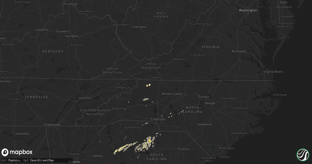
Hail Map in North Carolina on May 3, 2011
Get this storm
May 3 map
$229
one time, instant access
Download today. No call, no setup
Keep the $229
Bought the map and want the full workflow? Apply the entire $229 to a subscription within 7 days. None of it is wasted.
Every map, not just this one
This buys you this map. Subscription and you get every map we run, in the markets you choose from a few cities to whole states to nationwide. Plus real-time alerts the moment a storm fires.
Contact data
Name, contact info, occupancy, even credit band for addresses in the footprint. You go from where it hit to who to call.
Become the source they trust
Unlimited branding weather history reports on demand. You already have the documented answer ready for the property owner, and you are the one who showed up with it.
Property data and RoofTrace estimates
Pull up any address you have got, its value and the exact code rules for that jurisdiction, straight from One Click Code. Then RoofTrace estimates the squares, pitch, and roof value, priced the way you price.
Storm reports in North Carolina
North Carolina
| Date | Description |
|---|---|
| 05/03/20116:50 PM CDT | Powerlines and several trees are down in the community of jonesville. |
| 05/03/20116:45 PM CDT | Cleveland county emergency management reports multiple trees blown down along casar road in northern cleveland county. Most of the damage occurred near the intersection |
| 05/03/20116:23 PM CDT | County communications reports several trees down around ellendale. Also had reports of large hail but nobody gave a specific hail size. |
| 05/03/20115:55 PM CDT | A few trees down. |
| 05/03/20115:52 PM CDT | Hail began 652 pm and lasted 5 minutes. Mostly dime to quarter sized...a few golf ball sized. |
| 05/03/20115:40 PM CDT | County communications reports two or three trees down along highway 181 in the brown mountain area. |
| 05/03/20115:08 PM CDT | County communications center reports a few trees down mainly in the old fort area but also around sugar hill. A tree fell on a mobile home near old fort with no injurie |
| 05/03/20115:07 PM CDT | The mill creek road area in far western mcdowell county was especially hard hit with numerous trees down. No reports of any injuries as the earlier mobile home hit by a |
| 05/03/20115:00 PM CDT | One tree down across blue ridge road at the bridge and several other large limbs down |
| 05/03/20115:00 PM CDT | *** 1 inj *** numerous trees down in and just adjacent to black mountain. Highway 70 and many other roads are partially blocked from trees in the road. One injury occur |
| 05/03/20114:56 PM CDT | Large tree limbs down. |
| 05/02/201111:00 PM CDT | One tree was reported down along old liberty road at benny lineberry road. |
| 05/02/201111:00 PM CDT | One tree was reported down across nc highway 22 near brush creek road. |
| 05/02/201110:52 PM CDT | One tree down at the intersection of hwy 42 and moffitt mill rd. |
| 05/02/201110:42 PM CDT | One tree was reported down along caraway mountain road near conference center drive. |
| 05/02/20119:03 PM CDT | Spotter reports one large tree down off hickory grove road just outside of mcadenville. |
| 05/02/20117:20 PM CDT | A tree was blown down in the pilot mountain area. |
| 05/02/20117:15 PM CDT | Catawba county dot reports 2 trees down on lee cline road. |
| 05/02/20117:15 PM CDT | Catawba county dot reports 1 tree down on daniel street. |
| 05/02/20117:15 PM CDT | A tree was blown down in the community of siloam. |
| 05/02/20117:14 PM CDT | Catawba county reports a tree down on a mobile home in the 3400 block of highland avenue ne. |
| 05/02/20117:10 PM CDT | A tree fell on a mobile home on highland avenue. |
All States Impacted by Hail Map on May 3, 2011
Cities Impacted by Hail Map on May 3, 2011
- Gibson, GA
- Warthen, GA
- Mitchell, GA
- Millers Creek, NC
- Laurel Springs, NC
- Dudley, GA
- Dexter, GA
- Concord, NC
- Harrisburg, NC
- McGrady, NC
- Sparta, NC
- Blair, SC
- Saluda, SC
- Lancaster, SC
- Little Mountain, SC
- Pomaria, SC
- Shickshinny, PA
- Rochelle, GA
- Arabi, GA
- Vienna, GA
- Cordele, GA
- Pitts, GA
- Wapwallopen, PA
- Nanticoke, PA
- Clover, SC
- Mount Pleasant Mills, PA
- Beavertown, PA
- Middleburg, PA
- Richfield, PA
- Waterloo, SC
- Hodges, SC
- Abbeville, SC
- Clinton, SC
- Kinards, SC
- Newberry, SC
- Ridge Spring, SC
- Ward, SC
- Greenwood, SC
- Cross Hill, SC
- Bradley, SC
- Mountville, SC
- Wetumpka, AL
- Taylorsville, NC
- Port Royal, PA
- Honey Grove, PA
- East Dublin, GA
- Chester, GA
- Gaffney, SC
- Hudson, NC
- Lenoir, NC
- Granite Falls, NC
- Honea Path, SC
- Fountain Inn, SC
- Gray Court, SC
- Dublin, GA
- Blackstock, SC
- Winnsboro, SC
- Eastman, GA
- Berwick, PA
- Danville, PA
- Prosperity, SC
- Pineview, GA
- Atlanta, GA
- Chapin, SC
- Star, NC
- Silverstreet, SC
- Old Fort, NC
- Louisville, GA
- Midville, GA
- Toccoa, GA
- Eastanollee, GA
- Muncy, PA
- Bloomsburg, PA
- Abbeville, GA
- Marion, NC
- Orangeville, PA
- Millville, PA
- Cadwell, GA
- Calhoun Falls, SC
- New London, NC
- Richfield, NC
- Albemarle, NC
- McClure, PA
- Jackson, SC
- Augusta, GA
- Mifflinburg, PA
- Lewisburg, PA
- Newton, NC
- Hickory, NC
- White Haven, PA
- Blacksburg, SC
- York, SC
- Smyrna, SC
- Chester, SC
- Carlisle, SC
- Whitmire, SC
- Richburg, SC
- Jenkinsville, SC
- Joanna, SC
- Mountain Top, PA
- Wilkes Barre, PA
- Mill Creek, PA
- Stillwater, PA
- Keysville, GA
- Waynesboro, GA
- Seagrove, NC
- Ridgeway, SC
- Great Falls, SC
- Fort Lawn, SC
- Hawkinsville, GA
- Cochran, GA
- Rentz, GA
- Locust, NC
- Oakboro, NC
- Sunbury, PA
- Paxinos, PA
- Stony Point, NC
- Elberton, GA
- Batesburg, SC
- New Columbia, PA
- Union City, GA
- Warwick, GA
- Milton, PA
- Watsontown, PA
- Turbotville, PA
- Troy, NC
- Huntingdon, PA
- Millerstown, PA
- Hays, NC


