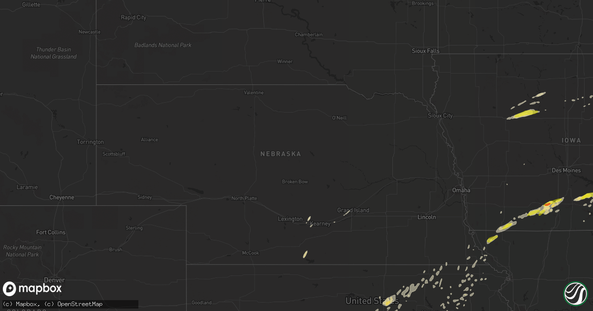
Hail Map in Nebraska on May 2, 2018
Get this storm
May 2 map
$229
one time, instant access
Download today. No call, no setup
Keep the $229
Bought the map and want the full workflow? Apply the entire $229 to a subscription within 7 days. None of it is wasted.
Every map, not just this one
This buys you this map. Subscription and you get every map we run, in the markets you choose from a few cities to whole states to nationwide. Plus real-time alerts the moment a storm fires.
Contact data
Name, contact info, occupancy, even credit band for addresses in the footprint. You go from where it hit to who to call.
Become the source they trust
Unlimited branding weather history reports on demand. You already have the documented answer ready for the property owner, and you are the one who showed up with it.
Property data and RoofTrace estimates
Pull up any address you have got, its value and the exact code rules for that jurisdiction, straight from One Click Code. Then RoofTrace estimates the squares, pitch, and roof value, priced the way you price.
Storm reports in Nebraska
Nebraska
| Date | Description |
|---|---|
| 05/02/20186:35 AM CDT | At 1134 AM CDT, a severe thunderstorm was located near Platte Center, or 8 miles northwest of Columbus, moving northeast at 35 mph. HAZARD...Quarter size hail. SOURCE...Radar indicated. IMPACT...Damage to vehicles is expected. Locations impacted include... Leigh, Platte Center, Monroe, Lake North Babcock Campground, Central Community College, College View Trailer Park, Lake Ocaonee, Circle H Trailer Park, Shell Creek Elementary School and Maple Creek Recreation Area.This includes Highway 81 in Nebraska between mile markers 116 and126. |
| 05/02/20181:41 AM CDT | At 641 PM CDT, severe thunderstorms were located along a line extending from 6 miles north of Sabetha to near Holton to 4 miles southeast of Delia, moving east at 35 mph. HAZARD...60 mph wind gusts and quarter size hail. SOURCE...Radar indicated. IMPACT...Hail damage to vehicles is expected. Expect wind damage to roofs, siding, and trees. Locations impacted include... Holton, Hiawatha, Horton, Valley Falls, Hoyt, Ozawkie, Nortonville, Winchester, Mayetta, Everest, Fairview, Robinson, Morrill, Whiting, Denison, Netawaka, Reserve, Powhattan, Hamlin and Willis. |
| 05/01/20187:14 PM CDT | Tree blown down in a cemetary at rulo. Time estimated based on radar. All rulo residents without power for approximately 1 hour. |
All States Impacted by Hail Map on May 2, 2018
Cities Impacted by Hail Map on May 2, 2018
- Chicago, IL
- Turon, KS
- Erie, KS
- New Glarus, WI
- Monticello, WI
- Christoval, TX
- Janesville, WI
- Albany, TX
- Crown Point, IN
- Peotone, IL
- Wilmington, IL
- Bourbonnais, IL
- Manteno, IL
- Beecher, IL
- Essex, IL
- Kankakee, IL
- Cedar Lake, IN
- Bonfield, IL
- Grant Park, IL
- Appleton City, MO
- Jetmore, KS
- Burkburnett, TX
- Hampshire, IL
- Huntley, IL
- Gilberts, IL
- Albany, IL
- Fulton, IL
- Erie, IL
- Dixon, IL
- Sterling, IL
- Morrison, IL
- Wakarusa, IN
- Nappanee, IN
- Richmond, IL
- Spring Grove, IL
- Twin Lakes, WI
- Genoa City, WI
- Hebron, IL
- Lake Geneva, WI
- Ness City, KS
- Perryton, TX
- Hesperia, MI
- Holton, MI
- St John, KS
- Great Bend, KS
- Ellinwood, KS
- Claflin, KS
- Albert, KS
- Larned, KS
- Pawnee Rock, KS
- Hoisington, KS
- Okeene, OK
- Drummond, OK
- Isabella, OK
- Enid, OK
- Ames, OK
- Waukomis, OK
- Excello, MO
- Cairo, MO
- Jacksonville, MO
- Huntsville, MO
- Throckmorton, TX
- Wetmore, KS
- Holton, KS
- Circleville, KS
- Marion, KS
- Peabody, KS
- Walton, KS
- Prophetstown, IL
- Lyndon, IL
- Rock Falls, IL
- Milford, IN
- Bremen, IN
- Bourbon, IN
- Fremont, MI
- Mineral Point, WI
- Valley Center, KS
- Abilene, TX
- Booker, TX
- Balko, OK
- Laverne, OK
- Dryden, TX
- Sheffield, TX
- Ozona, TX
- Pratt, KS
- Mullinville, KS
- Quanah, TX
- Osceola, IA
- Pleasant Valley, IA
- Le Claire, IA
- Bettendorf, IA
- Stamford, TX
- Cedar Point, KS
- Eldorado, TX
- Comstock, TX
- Sonora, TX
- Steward, IL
- Ashton, IL
- Rochelle, IL
- Altus, OK
- Ballinger, TX
- Norton, TX
- Winters, TX
- Hugo, CO
- Ramah, CO
- Rush, CO
- Lookeba, OK
- Binger, OK
- Beaver, OK
- Burchard, NE
- Axtell, KS
- Lawn, TX
- Blue Mounds, WI
- Leland, IL
- Earlville, IL
- Orleans, NE
- Alma, NE
- Somonauk, IL
- Kinsley, KS
- Forreston, IL
- Polo, IL
- Chadwick, IL
- Mount Carroll, IL
- Lanark, IL
- Milledgeville, IL
- Yoder, CO
- Matheson, CO
- Avondale, CO
- Pueblo, CO
- Belpre, KS
- Brooklyn, WI
- Evansville, WI
- Albany, WI
- Fort Cobb, OK
- Gracemont, OK
- Thayer, IA
- Murray, IA
- Hartford, WI
- Chase, KS
- Raymond, KS
- Lyons, KS
- Alden, KS
- Sugar City, CO
- Ordway, CO
- Eureka, KS
- Wichita Falls, TX
- Holliday, TX
- Tinley Park, IL
- Oak Forest, IL
- Country Club Hills, IL
- Electra, TX
- Onaga, KS
- Hastings, OK
- Temple, OK
- Chandler, OK
- Meeker, OK
- Wellston, OK
- Anadarko, OK
- Apache, OK
- O'Brien, TX
- Andale, KS
- Comanche, OK
- Marlow, OK
- Duncan, OK
- Byers, KS
- Pomeroy, IA
- Rockwell City, IA
- Clare, IA
- Jolley, IA
- Barnum, IA
- Manson, IA
- Keswick, IA
- Sigourney, IA
- What Cheer, IA
- Webster, IA
- Lone Wolf, OK
- Granite, OK
- Rocky, OK
- Gotebo, OK
- Cordell, OK
- Hobart, OK
- Minneapolis, KS
- Burrton, KS
- Palmer, KS
- Morganville, KS
- Clay Center, KS
- Clifton, KS
- Elmdale, KS
- Florence, KS
- Cottonwood Falls, KS
- Burns, KS
- Limon, CO
- Burlington, KS
- Le Roy, KS
- Gridley, KS
- Loveland, OK
- Chattanooga, OK
- Mangum, OK
- Darien, WI
- Arlington, KS
- Inman, KS
- Abbyville, KS
- Hutchinson, KS
- Sterling, KS
- Partridge, KS
- Nickerson, KS
- Plevna, KS
- Woodson, TX
- Anson, TX
- Lueders, TX
- Avoca, TX
- Windthorst, TX
- Rule, TX
- Haskell, TX
- Olney, TX
- Newcastle, TX
- Hamlin, TX
- Haven, KS
- Fontana, WI
- Lake Villa, IL
- Wadsworth, IL
- Delavan, WI
- Walworth, WI
- Williams Bay, WI
- Antioch, IL
- Burlington, WI
- Avalon, WI
- Footville, WI
- Beloit, WI
- Brodhead, WI
- Gurnee, IL
- Belleville, WI
- Fox Lake, IL
- Orfordville, WI
- Clinton, WI
- Sharon, WI
- Iraan, TX
- Lee, IL
- Oklahoma City, OK
- Norman, OK
- Wingate, TX
- Perrin, TX
- Breckenridge, TX
- Graford, TX
- Graham, TX
- Bryson, TX
- Jacksboro, TX
- Lake In The Hills, IL
- Crystal Lake, IL
- Idalia, CO
- Wray, CO
- Karval, CO
- Elmer, OK
- Tipton, OK
- South Elgin, IL
- Elgin, IL
- Walters, OK
- Grayslake, IL
- Libertyville, IL
- Waukegan, IL
- Crowell, TX
- Chillicothe, TX
- Vernon, TX
- Packwood, IA
- Mound City, KS
- Lowell, IN
- Momence, IL
- Lincoln, KS
- Garfield, KS
- Lewis, KS
- Syracuse, IN
- Etna Green, IN
- Sweetwater, OK
- Cheyenne, OK
- Lake Forest, IL
- Olmitz, KS
- Dorrance, KS
- Meade, KS
- Canton, KS
- Lorraine, KS
- Wilson, KS
- Stafford, KS
- Ellsworth, KS
- Haviland, KS
- Otis, KS
- Plains, KS
- Sylvia, KS
- Galva, KS
- Gate, OK
- Englewood, KS
- Windom, KS
- Spearville, KS
- Cunningham, KS
- Hillsboro, KS
- Macksville, KS
- Lehigh, KS
- Wright, KS
- Mcpherson, KS
- Buhler, KS
- Hudson, KS
- Forgan, OK
- Dodge City, KS
- Fowler, KS
- Kingman, KS
- Ford, KS
- Greensburg, KS
- Bushton, KS
- South Hutchinson, KS
- Holyrood, KS
- Moundridge, KS
- Bucklin, KS
- Offerle, KS
- Iuka, KS
- Minneola, KS
- Pretty Prairie, KS
- Atalissa, IA
- West Liberty, IA
- Gail, TX
- Iowa City, IA
- Wellman, IA
- Riverside, IA
- Kalona, IA
- Johnson Creek, WI
- Sun Prairie, WI
- Benson, IL
- Fort Sill, OK
- Sayre, OK
- Blanchard, IA
- New Market, IA
- Clarinda, IA
- College Springs, IA
- Bedford, IA
- Gravity, IA
- Elmo, MO
- Braddyville, IA
- Big Lake, TX
- Midland, TX
- Midkiff, TX
- Garden City, TX
- Lindsay, OK
- Rush Springs, OK
- Shamrock, TX
- Wheeler, TX
- Hydro, OK
- Carnegie, OK
- Fonda, IA
- Coal Valley, IL
- Moline, IL
- Milan, IL
- Auburn, NE
- Weinert, TX
- Franklin Grove, IL
- Argyle, WI
- Zion, IL
- Pleasant Prairie, WI
- Milton, WI
- Trevor, WI
- Blanchardville, WI
- Kenosha, WI
- Latimer, IA
- Geneseo, IL
- Russell, IA
- Chariton, IA
- Mustang, OK
- Paw Paw, IL
- Compton, IL
- West Brooklyn, IL
- Malta, IL
- Shabbona, IL
- Waterman, IL
- Ashland, KS
- Sandwich, IL
- Amherst, NE
- Elm Creek, NE
- Nocona, TX
- Bowie, TX
- Bellevue, TX
- Livermore, IA
- Humboldt, IA
- Thomson, IL
- Bryant, IA
- Clinton, IA
- Wakefield, KS
- Joliet, IL
- Plainfield, IL
- Minooka, IL
- Rulo, NE
- Falls City, NE
- Union City, OK
- Pecatonica, IL
- German Valley, IL
- Leaf River, IL
- Cherry Valley, IL
- Shannon, IL
- Belvidere, IL
- Freeport, IL
- Byron, IL
- Baileyville, IL
- Kirkland, IL
- Rockford, IL
- Winnebago, IL
- Devol, OK
- Grandfield, OK
- Randlett, OK
- Putnam, OK
- Oakwood, OK
- Seiling, OK
- Taloga, OK
- Canton, OK
- Yorkville, IL
- Craig, MO
- Burlington Junction, MO
- Fairfax, MO
- Tarkio, MO
- Clyde, TX
- Elburn, IL
- Saint Charles, IL
- Barneveld, WI
- Ridgeway, WI
- Emmett, KS
- Delia, KS
- Aurora, KS
- Delphos, KS
- Clyde, KS
- Miltonvale, KS
- Concordia, KS
- Elgin, OK
- Oklaunion, TX
- Tuscola, TX
- Maple Park, IL
- Tarzan, TX
- Eagle, WI
- Sylvester, TX
- Bussey, IA
- Robert Lee, TX
- Carlsbad, TX
- Hollister, OK
- Harrold, TX
- Davidson, OK
- Eldorado, OK
- Snyder, OK
- Indiahoma, OK
- Geronimo, OK
- Seymour, TX
- Olustee, OK
- Iowa Park, TX
- Odell, TX
- Frederick, OK
- Paducah, TX
- Cary, IL
- South Bend, IN
- Savanna, IL
- Sabula, IA
- Preston, IA
- Miles, IA
- Charlotte, IA
- Alma, KS
- San Angelo, TX
- Mertzon, TX
- Grand Mound, IA
- Delmar, IA
- Teeds Grove, IA
- Mount Morris, IL
- Tipton, IA
- West Branch, IA
- Halstead, KS
- Eldridge, IA
- Long Grove, IA
- Harmon, IL
- Amber, OK
- Tuttle, OK
- Sterling City, TX
- Delta, IA
- Twin Lake, MI
- Newaygo, MI
- Muskegon, MI
- Grant, MI
- Pocasset, OK
- Minco, OK
- Monee, IL
- Moravia, IA
- Blakesburg, IA
- Albia, IA
- Loraine, TX
- Dekalb, IL
- Chanute, KS
- La Grange, IL
- Summit Argo, IL
- Shannon City, IA
- Diagonal, IA
- Arlington, CO
- Lebo, KS
- New Athens, IL
- Maysville, OK
- Roscoe, TX
- Parnell, IA
- Northbrook, IL
- Glencoe, IL
- Winnetka, IL
- Munday, TX
- Spragueville, IA
- Zenda, KS
- Afton, IA
- Hinton, OK
- Sullivan, WI
- Helenville, WI
- Edgerton, WI
- Wynnewood, OK
- Barrington, IL
- Lake Zurich, IL
- New Liberty, IA
- Bennett, IA
- Welda, KS
- Kincaid, KS
- Colony, KS
- Garnett, KS
- Blue Mound, KS
- Hillsdale, IL
- Mount Hope, KS
- Atlantic, IA
- Manhattan, KS
- Van Wert, IA
- Weldon, IA
- Vancourt, TX
- Waterloo, WI
- Deerfield, WI
- Jefferson, WI
- Oconomowoc, WI
- Watertown, WI
- Marshall, WI
- Lake Mills, WI
- Mount Horeb, WI
- Cassville, WI
- Holy Cross, IA
- North Buena Vista, IA
- Guttenberg, IA
- Vincent, IA
- Elkhart, IN
- Seneca, KS
- Bern, KS
- Goldsmith, TX
- Andrews, TX
- Mount Pleasant, MI
- Blackwell, TX
- Donahue, IA
- Dixon, IA
- Davenport, IA
- Walcott, IA
- Princeton, IA
- Stillman Valley, IL
- Lindenwood, IL
- Davis Junction, IL
- Oregon, IL
- Monroe Center, IL
- Esmond, IL
- Frankfort, KS
- Burlington, CO
- Bethune, CO
- Stratton, CO
- Lenorah, TX
- Madison, KS
- East Moline, IL
- Silvis, IL
- Geneva, IA
- Goshen, IN
- Waverly, KS
- Dousman, WI
- Hiawatha, KS
- Morrill, KS
- Boone, CO
- Sublette, IL
- Amboy, IL
- Kingston, IL
- Chana, IL
- Holcomb, IL
- Burdick, KS
- Melrose, IA
- Lovilia, IA
- Matfield Green, KS
- Wheatfield, IN
- Wichita, KS
- Independence, KS
- Purcell, OK
- Blanchard, OK
- Hebron, IN
- Sheridan, IL
- Ninnekah, OK
- Cement, OK
- Chickasha, OK
- Fairfield, IA
- Brighton, IA
- Tingley, IA
- New Virginia, IA
- Ellston, IA
- Lenox, IA
- Sharpsburg, IA
- Clearfield, IA
- Grand River, IA
- Port Byron, IL
- Loving, TX
- Henrietta, TX
- Plano, IA
- Ackerly, TX
- Olpe, KS
- Dwight, IL
- Ransom, IL
- Blackstone, IL
- Kinsman, IL
- Mukwonago, WI
- Duke, OK
- Ixonia, WI
- Ashippun, WI
- Cedarburg, WI
- Sycamore, IL
- Genoa, IL
- Hoffman Estates, IL
- Dundee, IL
- Carpentersville, IL
- Palatine, IL
- Rewey, WI
- Buffalo, OK
- Rosston, OK
- Stanton, TX
- Delhi, IA
- Hopkinton, IA
- Columbia, IA
- Knoxville, IA
- San Pierre, IN
- Kouts, IN
- North Judson, IN
- Demotte, IN
- La Crosse, IN
- Colwich, KS
- Hennepin, OK
- Ratliff City, OK
- Clifton Hill, MO
- Reydon, OK
- Bridgeview, IL
- Wamego, KS
- Caney, KS
- Tyro, KS
- Stillwater, OK
- Briscoe, TX
- Corydon, IA
- Willow, OK
- Mountain View, OK
- North Chicago, IL
- Algonquin, IL
- Wauconda, IL
- Fox River Grove, IL
- Vernon Hills, IL
- Mchenry, IL
- Mundelein, IL
- Island Lake, IL
- Tescott, KS
- Reading, KS
- Barnhart, TX
- Meno, OK
- Lahoma, OK
- Barnard, KS
- Beverly, KS
- Southard, OK
- Fairmont, OK
- Erick, OK
- Lamesa, TX
- Maryneal, TX
- Wasco, IL
- Milwaukee, WI
- Rowan, IA
- Clarion, IA
- Okemah, OK
- Sweetwater, TX
- Tracy, IA
- Westphalia, KS
- Hartford, KS
- Centerville, KS
- Rye, CO
- Guthrie Center, IA
- Robinson, KS
- Whitewater, KS
- Lagrange, IN
- Wolcottville, IN
- Spivey, KS
- Edmond, OK
- Gould, OK
- Hollis, OK
- Red Rock, OK
- Perry, OK
- McCaulley, TX
- Ovalo, TX
- Beattie, KS
- Summerfield, KS
- Alex, OK
- Bradley, OK
- Aredale, IA
- Hampton, IA
- Dumont, IA
- Blue Island, IL
- Midlothian, IL
- Palos Heights, IL
- Oak Lawn, IL
- Alsip, IL
- Worth, IL
- Crestwood, IL
- Palos Park, IL
- Gardner, IL
- Goff, KS
- Coldwater, KS
- Oregon, WI
- Lewistown, MO
- Tecumseh, MI
- Britton, MI
- Hinckley, IL
- Fairview, KS
- Bremen, KS
- Centralia, KS
- Corning, KS
- Bellevue, IA
- Soldier, KS
- Mayetta, KS
- Elmore City, OK
- Carbon Cliff, IL
- New Sharon, IA
- Harper, IA
- South English, IA
- Rose Hill, IA
- Waukesha, WI
- Cottage Grove, WI
- North Prairie, WI
- Delafield, WI
- Wales, WI
- Ottawa, IL
- Home, KS
- Oketo, KS
- Marysville, KS
- Netawaka, KS
- Merkel, TX
- Hawley, TX
- Aspermont, TX
- Archer City, TX
- Old Glory, TX
- Jermyn, TX
- Franksville, WI
- Muskego, WI
- Big Rock, IL
- Mendota, IL
- Springer, OK
- Coyle, OK
- Perkins, OK
- Elmwood, IL
- Roosevelt, OK
- Cordova, IL
- Camanche, IA
- Sedgwick, KS
- Newton, KS
- Rutland, IA
- Maize, KS
- Emporia, KS
- Foster, OK
- Bronte, TX
- Dakota City, IA
- Pearl City, IL
- Sugar Grove, IL
- Green, KS
- Greenleaf, KS
- Linn, KS
- Barnes, KS
- Sentinel, OK
- Vinson, OK
- Verden, OK
- Dodson, TX
- Childress, TX
- Worthington, IA
- Custer City, OK
- Wilson, OK
- Ringling, OK
- Butler, MO
- Pleasanton, KS
- Prescott, KS
- Hamilton, IA
- Fremont, IA
- Lacona, IA
- Leighton, IA
- Oskaloosa, IA
- Gibson, IA
- Copan, OK
- Ridott, IL
- Whiting, KS
- Horton, KS
- Powhattan, KS
- Tampico, IL
- Sharon, KS
- Murdock, KS
- Everest, KS
- Hammon, OK
- Hanna, OK
- Cyril, OK
- Guthrie, OK
- Meridian, OK
- Goose Lake, IA
- Saint George, KS
- Waterford, WI
- Macon, MO
- Salisbury, MO
- Saint Marys, KS
- New Carlisle, IN
- Serena, IL
- Brimfield, IL
- Waurika, OK
- Hartland, WI
- Havensville, KS
- Sabetha, KS
- Waterville, KS
- Burneyville, OK
- Dawson, NE
- Verdon, NE
- Blue Rapids, KS
- Ashley, IL
- Letts, IA
- Muscatine, IA
- Moran, TX
- Mossville, IL
- Peoria, IL
- West Salem, IL
- Lawton, OK
- Casnovia, MI
- Saint Jo, TX
- Leon, OK
- Nashua, IA
- Villisca, IA
- Whitewater, WI
- Colgate, WI
- Sussex, WI
- Goddard, KS
- Osceola, IN
- Madison, WI
- Neosho, WI
- Gilmore City, IA
- Pocahontas, IA
- Palmer, IA
- Delaware, OK
- Fort Dodge, IA
- Lytton, IA
- Sac City, IA
- Kansasville, WI
- Mystic, IA
- Wheeling, IL
- Prospect Heights, IL
- Linden, WI
- Maquoketa, IA
- Bartlett, IL
- Schaumburg, IL
- Arlington Heights, IL
- Burlington, IL
- Mount Prospect, IL
- Wayne, IL
- Cortland, IL
- Rolling Meadows, IL
- Clare, IL
- Glenview, IL
- Rich Hill, MO
- Fruitport, MI
- White Cloud, MI
- Ravenna, MI
- Wood River, NE
- Scotland, TX
- Elkhorn, WI
- Shelton, NE
- Hardy, IA
- Renwick, IA
- Bode, IA
- Ottumwa, IA
- Rockville, MO
- Fenton, IL
- Big Spring, TX
- Alda, NE
- Pawnee, OK
- Morrison, OK
- Russell, KS
- Byers, TX
- Petrolia, TX
- Verona, WI
- Pauls Valley, OK
- Rubicon, WI
- Iron Ridge, WI
- Clearwater, KS
- Haysville, KS
- Stoughton, WI
- Jayton, TX
- Shubert, NE
- Horicon, WI
- Mayville, WI
- Overbrook, OK
- La Moille, IL
- Washington, IA
- Ainsworth, IA
- Knox City, TX
- Neosho Rapids, KS
- Mapleton, KS
- North Liberty, IN
- Lakeville, IN
- Alexander, IA
- Dodgeville, WI
- Waggoner, IL
- Girard, IL
- Wayne, OK
- Gruver, TX
- Mishawaka, IN
- Ardmore, OK
- Keota, IA
- Hills, IA
- Geneva, IL
- West Chicago, IL
- Bristol, IN
- Menomonee Falls, WI
- Lannon, WI
- Lees Summit, MO
- Kansas City, MO
- Olathe, KS
- Overland Park, KS
- Grandview, MO
- Leawood, KS
- Elk City, OK
- Altus Afb, OK
- Coats, KS


