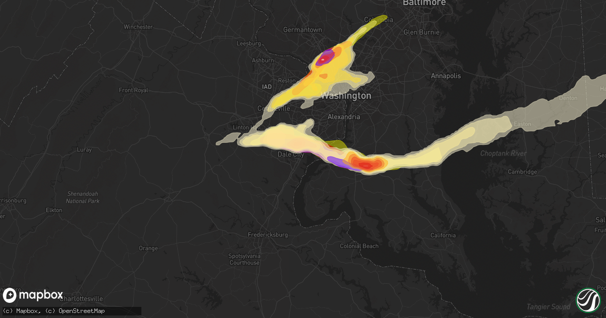
Hail Map in Woodbridge, VA on May 2, 2016
Get this storm
May 2 map
$229
one time, instant access
Download today. No call, no setup
Keep the $229
Bought the map and want the full workflow? Apply the entire $229 to a subscription within 7 days. None of it is wasted.
Every map, not just this one
This buys you this map. Subscription and you get every map we run, in the markets you choose from a few cities to whole states to nationwide. Plus real-time alerts the moment a storm fires.
Contact data
Name, contact info, occupancy, even credit band for addresses in the footprint. You go from where it hit to who to call.
Become the source they trust
Unlimited branding weather history reports on demand. You already have the documented answer ready for the property owner, and you are the one who showed up with it.
Property data and RoofTrace estimates
Pull up any address you have got, its value and the exact code rules for that jurisdiction, straight from One Click Code. Then RoofTrace estimates the squares, pitch, and roof value, priced the way you price.
Storm reports in Woodbridge, VA
Woodbridge, VA
| Date | Description |
|---|---|
| 05/02/20165:35 PM CDT | Near tennis ball size hail reported near occoquan and lorton |
| 05/02/20165:34 PM CDT | A local report indicates 1.75 inch wind near LAKE RIDGE |
| 05/02/20165:27 PM CDT | Quarter size hail |
| 05/02/20165:25 PM CDT | Golf ball size hail |
| 05/02/20165:22 PM CDT | A local report indicates 1.00 inch wind near 2 N DALE CITY |
| 05/02/20165:20 PM CDT | Golf ball size hail |
| 05/02/20165:18 PM CDT | Multiple trees down on dale boulevard near forestdale avenue. |
All States Impacted by Hail Map on May 2, 2016
All Cities Impacted by Hail Map on May 2, 2016
- Manchester, KY
- Ahoskie, NC
- Milton, DE
- Georgetown, DE
- Booneville, KY
- Sextons Creek, KY
- Tyner, KY
- Bethesda, MD
- Cabin John, MD
- Glen Echo, MD
- McLean, VA
- Kensington, MD
- Chevy Chase, MD
- Rockville, MD
- Silver Spring, MD
- Vienna, VA
- Falls Church, VA
- Garrett Park, MD
- Potomac, MD
- Raleigh, NC
- Newport, TN
- Lexington, NC
- Macon, GA
- Haddock, GA
- Gordon, GA
- Concord, NC
- Midland, NC
- Apex, NC
- Cary, NC
- Thousandsticks, KY
- Hyden, KY
- Ridgeway, SC
- Winnsboro, SC
- Great Falls, SC
- Augusta, GA
- North Augusta, SC
- Oneida, KY
- Candor, NC
- Ellerbe, NC
- Woodbridge, VA
- Wadesboro, NC
- Morven, NC
- Chesterfield, SC
- Ruby, SC
- Whitesburg, KY
- Ermine, KY
- Thornton, KY
- Iaeger, WV
- Herndon, WV
- Davy, WV
- Pineville, WV
- Welch, WV
- Cascade, VA
- Ruffin, NC
- Pelham, NC
- Manassas, VA
- Willis, VA
- Indian Valley, VA
- Dugspur, VA
- High Point, NC
- Greensboro, NC
- Jamestown, NC
- Springfield, VA
- Mount Airy, NC
- Ararat, VA
- Claudville, VA
- Pembroke, VA
- Ripplemead, VA
- Newport, VA
- Narrows, VA
- New Castle, VA
- Peterstown, WV
- Suffolk, VA
- Waldorf, MD
- Accokeek, MD
- La Plata, MD
- Pomfret, MD
- White Plains, MD
- Hays, NC
- Traphill, NC
- Sparta, NC
- Glade Valley, NC
- Dobson, NC
- Thurmond, NC
- Ringgold, VA
- Sutherlin, VA
- Columbia, VA
- Monroe, NC
- Wingate, NC
- Millsboro, DE
- Lewes, DE
- Harbeson, DE
- Spring City, TN
- Ten Mile, TN
- Gretna, VA
- Princeton, WV
- Athens, WV
- Neon, KY
- Seco, KY
- Millstone, KY
- Spring Grove, VA
- Disputanta, VA
- Pipestem, WV
- Mason, TX
- Fredericksburg, TX
- Winterville, NC
- Ayden, NC
- Grimesland, NC
- Greenville, NC
- Susan, VA
- Onemo, VA
- Port Haywood, VA
- Mathews, VA
- White Pine, TN
- Mount Gilead, NC
- Hookerton, NC
- Decatur, TN
- Kimper, KY
- Phyllis, KY
- Pikeville, KY
- Fedscreek, KY
- Elkhorn City, KY
- Pittsboro, NC
- Louisburg, NC
- Zebulon, NC
- Paint Bank, VA
- Stone, KY
- Canada, KY
- Harold, KY
- Sidney, KY
- Raccoon, KY
- McAndrews, KY
- Westfield, NC
- Windsor, VA
- Smithfield, VA
- Zuni, VA
- Charles City, VA
- Saluda, VA
- Gloucester, VA
- Franklinton, NC
- Youngsville, NC
- Wake Forest, NC
- Trafford, AL
- Oneonta, AL
- Remlap, AL
- Ferrum, VA
- Floyd, VA
- Callaway, VA
- Rocky Mount, VA
- Edgefield, SC
- Germanton, NC
- King, NC
- Black Mountain, NC
- Old Fort, NC
- Jackson, KY
- Clayhole, KY
- Whick, KY
- Hazard, KY
- Chavies, KY
- Rowdy, KY
- Lost Creek, KY
- Rock Hill, SC
- Edgemoor, SC
- Hamlet, NC
- Rockingham, NC
- Harrisburg, NC
- Gatesville, NC
- Hobbsville, NC
- Kittrell, NC
- Walnut Cove, NC
- Greenville, WV
- Amherst, VA
- Big Island, VA
- Monroe, VA
- Buchanan, VA
- Natural Bridge Station, VA
- Glasgow, VA
- Buena Vista, VA
- Natural Bridge, VA
- Lenoir City, TN
- Knoxville, TN
- Louisville, TN
- Kingston, TN
- Loudon, TN
- Farragut, TN
- Snow Hill, NC
- Bluefield, WV
- Chesapeake, VA
- Buckhead, GA
- Washington, NC
- Thomasville, NC
- South Boston, VA
- Vernon Hill, VA
- Halifax, VA
- Keeling, VA
- Scottsville, VA
- Cartersville, VA
- Goochland, VA
- Palmyra, VA
- Bremo Bluff, VA
- Howardsville, VA
- New Canton, VA
- Arvonia, VA
- Fork Union, VA
- Lancaster, SC
- Afton, VA
- Lovingston, VA
- Piney River, VA
- Roseland, VA
- Arrington, VA
- Nellysford, VA
- Faber, VA
- Danville, VA
- Gwynn, VA
- Hudgins, VA
- Moon, VA
- Foster, VA
- North, VA
- Cardinal, VA
- Cobbs Creek, VA
- Accomac, VA
- Painter, VA
- Brookneal, VA
- Phenix, VA
- Huntingtown, MD
- Sunderland, MD
- Chesapeake Beach, MD
- Llano, TX
- Caryville, TN
- La Follette, TN
- Pioneer, TN
- Nathalie, VA
- Lumberton, NC
- Trinity, NC
- Germantown, MD
- Creston, NC
- Lansing, NC
- Mountain City, TN
- Harrington, DE
- East Bend, NC
- Clover, VA
- Randolph, VA
- Crystal Hill, VA
- Java, VA
- Union Hall, VA
- Glade Hill, VA
- Winston Salem, NC
- Clemmons, NC
- Laurel Hill, NC
- Rolesville, NC
- Clarkrange, TN
- Sunbright, TN
- Deer Lodge, TN
- Kimball, WV
- Paynesville, WV
- Hurley, VA
- Northfork, WV
- Camp Creek, WV
- Panther, WV
- Lashmeet, WV
- Spanishburg, WV
- Matoaka, WV
- Beeson, WV
- Jolo, WV
- Grundy, VA
- Flat Top, WV
- Odd, WV
- Arlington, VA
- Washington, DC
- Naval Anacost Annex, DC
- Renick, WV
- Hillsboro, WV
- Shipman, VA
- Brandywine, MD
- Catlett, VA
- Bryans Road, MD
- Burke, VA
- Wittman, MD
- Tilghman, MD
- Bozman, MD
- Occoquan, VA
- Bristow, VA
- North Beach, MD
- Neavitt, MD
- Fort Belvoir, VA
- Fairfax Station, VA
- Clifton, VA
- Aquasco, MD
- Sherwood, MD
- Owings, MD
- Easton, MD
- Royal Oak, MD
- Indian Head, MD
- Nokesville, VA
- Saint Michaels, MD
- Lorton, VA
- Mcdaniel, MD
- Jewell Ridge, VA
- Berwind, WV
- Squire, WV
- Bandy, VA
- Donalds, SC
- Fairview, NC
- Nebo, NC
- Marion, NC
- Eagle Rock, VA
- Holly Springs, NC
- New Hill, NC
- Waxhaw, NC
- Pinnacle, NC
- Lawsonville, NC
- Sandy Ridge, NC
- Tobaccoville, NC
- Danbury, NC
- Moncure, NC
- Chester, SC
- Blackstock, SC
- McColl, SC
- Bluefield, VA
- North Tazewell, VA
- Fayetteville, NC
- Milford, DE
- Ellendale, DE
- Cordova, MD
- Lovely, KY
- Belfry, KY
- Williamson, WV
- Pilgrim, KY
- Fairfax, VA
- Herndon, VA
- Oakton, VA
- Walkertown, NC
- Rural Hall, NC
- Glenn Dale, MD
- Greenbelt, MD
- Lanham, MD
- Bowie, MD
- Newsoms, VA
- Franklin, VA
- Como, NC
- Gates, NC
- Courtland, VA
- Pinetown, NC
- Pantego, NC
- Evans, GA
- Troutville, VA
- Fincastle, VA
- Morganton, NC
- Greeneville, TN
- Afton, TN
- Bastian, VA
- Tazewell, VA
- Newland, NC
- Carrollton, VA
- Ricetown, KY
- Buckhorn, KY
- Gays Creek, KY
- Williamsburg, VA
- Greensboro, GA
- Penhook, VA
- Huntersville, NC
- Denton, MD
- Mousie, KY
- Wayland, KY
- Eastern, KY
- Langley, KY
- Garrett, KY
- Hueysville, KY
- Charlotte, TN
- White Bluff, TN
- Forkland, AL
- Prince George, VA
- Hayes, VA
- Yorktown, VA
- Hopewell, VA
- Lanexa, VA
- Waverly, VA
- Toano, VA
- Rising Fawn, GA
- La Fayette, GA
- Menlo, GA
- Rock Spring, GA
- Chickamauga, GA
- Ringgold, GA
- Hayden, AL
- Drift, KY
- Lackey, KY
- Minnie, KY
- McDowell, KY
- Hi Hat, KY
- Advance, NC
- Harrellsville, NC
- Felton, DE
- Greenwood, DE
- Preston, MD
- Greensboro, MD
- Cofield, NC
- Winton, NC
- Eure, NC
- Exmore, VA
- Cumberland, VA
- Trenton, SC
- Grovetown, GA
- Mechanicsville, VA
- Laurinburg, NC
- Coffeeville, AL
- Emmalena, KY
- Leburn, KY
- Vest, KY
- Bulan, KY
- Taylorsville, NC
- Phelps, KY
- Stopover, KY
- Salyersville, KY
- Gunlock, KY
- Lerona, WV
- Ridgeway, VA
- Callands, VA
- Rich Creek, VA
- Glen Lyn, VA
- Waiteville, WV
- Falls Mills, VA
- Pearisburg, VA
- Prestonsburg, KY
- Delbarton, WV
- Ivanhoe, NC
- Harrells, NC
- Reidsville, GA
- Printer, KY
- Garner, KY
- Grethel, KY
- Eutawville, SC
- Boykins, VA
- Lindside, WV
- Stanley, NC
- Claxton, GA
- Register, GA
- Gaithersburg, MD
- Dunn Loring, VA
- Reston, VA
- Great Falls, VA
- Schuyler, VA
- Jefferson, NC
- Crumpler, NC
- Shelbiana, KY
- Society Hill, SC
- Cheraw, SC
- Annville, KY
- Cumberland Furnace, TN
- Dickson, TN
- Vanleer, TN
- Philadelphia, TN
- Topmost, KY
- Teaberry, KY
- Beaver, KY
- Bevinsville, KY
- Dema, KY
- Catawba, SC
- Fort Lawn, SC
- Willard, NC
- Broad Run, VA
- Kernersville, NC
- Ballard, WV
- Ashburn, VA
- Sterling, VA
- Esmont, VA
- Marston, NC
- Wagram, NC
- Mount Croghan, SC
- McRoberts, KY
- Jenkins, KY
- Chuckey, TN
- Clarks Hill, SC
- Saulsville, WV
- Colerain, NC
- Milledgeville, GA
- Shelby Gap, KY
- Salisbury, NC
- Rockwell, NC
- China Grove, NC
- Indian Trail, NC
- Charlotte, NC
- Matthews, NC
- Blacksburg, VA
- Catawba, VA
- Lenore, WV
- Willow Spring, NC
- Fuquay Varina, NC
- McEwen, TN
- Highland, MD
- Fulton, MD
- Clarksville, MD
- Copper Hill, VA
- Lexington, VA
- Hurt, VA
- Vinton, VA
- Roxana, KY
- Mayking, KY
- Premium, KY
- Mistletoe, KY
- Cape Charles, VA
- Poolesville, MD
- Marshville, NC
- Piney Creek, NC
- State Road, NC
- Elkin, NC
- Rehoboth Beach, DE
- Roanoke, VA
- Dandridge, TN
- Bybee, TN
- Richburg, SC
- Statesville, NC
- Hendersonville, NC
- Catharpin, VA
- Gainesville, VA
- Graniteville, SC
- Gap Mills, WV
- Yadkinville, NC
- Dwarf, KY
- Buckeye, WV
- Quinwood, WV
- Riverdale, MD
- Chantilly, VA
- Hyattsville, MD
- Brentwood, MD
- College Park, MD
- Ashton, MD
- Takoma Park, MD
- Mount Rainier, MD
- Centreville, VA
- Wharncliffe, WV
- Brenton, WV
- Montebello, VA
- Tyro, VA
- Altoona, AL
- Boaz, AL
- Rowland, NC
- Pembroke, NC
- Sunflower, AL
- Wagarville, AL
- Wayside, WV
- Forest Hill, WV
- Jachin, AL
- Blackey, KY
- Letcher, KY
- Ashcamp, KY
- Hallie, KY
- Branchville, VA
- Polkton, NC
- Peachland, NC
- Federalsburg, MD
- Denton, NC
- Gladstone, VA
- Kinston, NC
- Claremont, NC
- Cleveland, NC
- Washington, LA
- Palmetto, LA
- Stony Point, NC
- Conover, NC
- Woodleaf, NC
- Lexington, SC
- Graham, NC
- Haw River, NC
- Port Wentworth, GA
- Wallace, SC
- Spring Grove, PA
- Hanover, PA
- Warrenville, SC
- Aiken, SC
- Warrenton, NC
- Maxton, NC
- Sandy Spring, MD
- Houston, DE
- Ararat, NC
- Pilot Mountain, NC
- Richwood, WV
- Rose Hill, NC
- Alexandria, VA
- Dendron, VA
- Mebane, NC
- Vance, SC
- Stokes, NC
- Chatham, VA
- Pittsville, VA
- Sandy Level, VA
- Sanford, NC
- Aldie, VA
- Beech Island, SC
- Pleasant Hill, NC
- Seaboard, NC
- Emporia, VA
- Margarettsville, NC
- Burlington, NC
- Richfield, NC
- Gold Hill, NC
- Saint Leonard, MD
- Johnston, SC
- Keysville, VA
- Buckingham, VA
- Lick Creek, KY
- Wingina, VA
- Covesville, VA
- Rockford, TN
- Bladensburg, MD
- Mocksville, NC
- Rockwood, TN
- Big Rock, VA
- Modoc, SC
- Steele, KY
- Regina, KY
- Mouthcard, KY
- Belcher, KY
- Oak Ridge, NC
- Raeford, NC
- Doss, TX
- Plymouth, NC
- Bath, NC
- Bennettsville, SC
- Rhodell, WV
- Slab Fork, WV
- Stuart, VA
- Jefferson City, TN
- Chocowinity, NC
- Blounts Creek, NC
- Lake Lure, NC
- Dagsboro, DE
- Pageland, SC
- Upper Marlboro, MD
- Columbia, MD
- Prince Frederick, MD
- Mechanicsville, MD
- Port Republic, MD
- Julian, NC
- Climax, NC
- Annandale, VA
- Lincoln, DE
- Warrenton, VA
- Spencerville, MD
- Bladenboro, NC
- Chapel Hill, NC
- Durham, NC
- Bohannon, VA
- Laurel Springs, NC
- Lynch Station, VA
- Randleman, NC
- Sophia, NC
- Yanceyville, NC
- Omar, WV
- Logan, WV
- Huddy, KY
- Pinsonfork, KY
- Hardy, KY
- McCarr, KY
- Ransom, KY
- Rock, WV
- Hinton, WV
- Huddleston, VA
- Marlinton, WV
- Charlotte Court House, VA
- Richmond, VA
- Mouth Of Wilson, VA
- Cooleemee, NC
- Maceo, KY
- Rockport, IN
- Marysville, IN
- Borden, IN
- Henryville, IN
- Goshen, KY
- Westport, KY
- La Grange, KY
- Charlestown, IN
- Pekin, IN
- Memphis, IN
- Sellersburg, IN
- Bethlehem, KY
- Lockport, KY
- Pleasureville, KY
- Smithfield, KY
- Eminence, KY
- New Castle, KY
- Lawrenceburg, KY
- Salvisa, KY
- Simpsonville, KY
- Nicholasville, KY
- Lexington, KY
- Wilmore, KY
- Versailles, KY
- Georgetown, IN
- New Albany, IN
- Floyds Knobs, IN
- Owensboro, KY
- Henderson, KY
- Lanesville, IN


