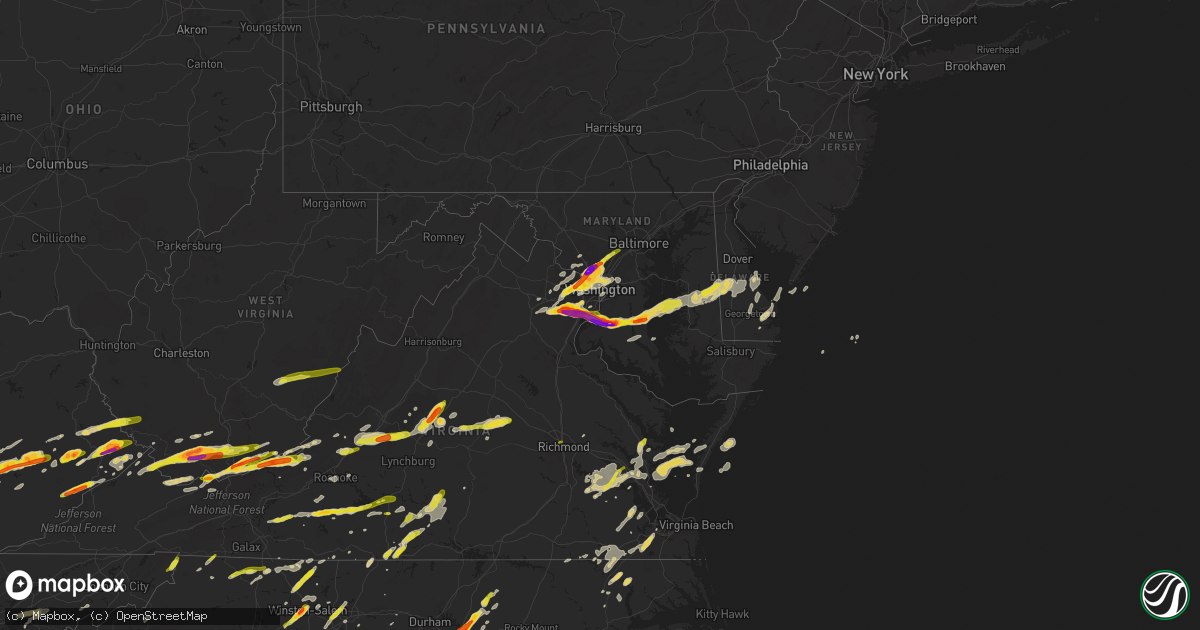
Hail Map on May 2, 2016
Get this storm
May 2 map
$229
one time, instant access
Download today. No call, no setup
Keep the $229
Bought the map and want the full workflow? Apply the entire $229 to a subscription within 7 days. None of it is wasted.
Every map, not just this one
This buys you this map. Subscription and you get every map we run, in the markets you choose from a few cities to whole states to nationwide. Plus real-time alerts the moment a storm fires.
Contact data
Name, contact info, occupancy, even credit band for addresses in the footprint. You go from where it hit to who to call.
Become the source they trust
Unlimited branding weather history reports on demand. You already have the documented answer ready for the property owner, and you are the one who showed up with it.
Property data and RoofTrace estimates
Pull up any address you have got, its value and the exact code rules for that jurisdiction, straight from One Click Code. Then RoofTrace estimates the squares, pitch, and roof value, priced the way you price.
States Impacted by Hail Map on May 2, 2016
Storm reports
Georgia
| Date | Description |
|---|---|
| 05/01/20168:10 PM CDT | Public reported golf ball sized hail |
North Carolina
| Date | Description |
|---|---|
| 05/02/20165:50 PM CDT | Quarter size hail near the tn state line |
| 05/02/20165:40 PM CDT | Up to quarter sized hail nw of cooleemee. |
| 05/02/20165:01 PM CDT | Scattered reports of power outtages from numerous fallen trees and tree limbs |
| 05/02/20164:56 PM CDT | A local report indicates 1.00 inch wind near 4 N STATESVILLE |
| 05/02/20164:28 PM CDT | Danbury em reports hail up to the size of a quarter in the city of danbury in stokes county north carolina. |
| 05/02/20164:25 PM CDT | Hanging rock state park |
| 05/02/20164:25 PM CDT | Several trees reported down on peach orchird road... Mays cross roads and route 401 south of louisburg. |
| 05/02/20164:15 PM CDT | Several trees were blown down... Five of which fell onto area homes. Quarter size hail also covered the ground. |
| 05/02/20164:15 PM CDT | Several reports of trees down near the guilford courthouse park. |
| 05/02/20164:06 PM CDT | A local report indicates 1.00 inch wind near 3 SE YOUNGSVILLE |
| 05/02/20164:05 PM CDT | A local report indicates 1.50 inch wind near 3 SSE YOUNGSVILLE |
| 05/02/20164:05 PM CDT | A local report indicates 1.75 inch wind near 3 SSW PFAFFTOWN |
| 05/02/20164:05 PM CDT | Trees snapped and uprooted on quarry road. |
| 05/02/20164:05 PM CDT | Tree down on a home on gretchen lane. |
| 05/02/20164:00 PM CDT | A local report indicates 1.00 inch wind near 5 NNE JAMESTOWN |
| 05/02/20164:00 PM CDT | Two trees down in king |
| 05/02/20164:00 PM CDT | A local report indicates 1.00 inch wind near 2 SW WAKE FOREST |
| 05/02/20163:56 PM CDT | A local report indicates 1.00 inch wind near 5 W GREENSBORO |
| 05/02/20163:50 PM CDT | A local report indicates 1.75 inch wind near 2 SSW WAKE FOREST |
| 05/02/20163:45 PM CDT | A local report indicates 1.00 inch wind near 3 WSW WINSTON-SALEM |
| 05/02/20163:34 PM CDT | A local report indicates 1.00 inch wind near 3 ENE RALEIGH |
| 05/02/20163:30 PM CDT | A local report indicates 1.25 inch wind near RALEIGH |
| 05/02/20163:27 PM CDT | Quarter size hail on buck jones road. |
| 05/02/20163:21 PM CDT | A local report indicates 2.00 inch wind near 2 SE CARY |
| 05/02/20163:20 PM CDT | Quarter size hail on red hill creek rd |
| 05/02/20163:18 PM CDT | A local report indicates 1.50 inch wind near 3 SSE CARY |
| 05/02/20163:16 PM CDT | A local report indicates 1.00 inch wind near 3 S CARY |
| 05/02/20163:14 PM CDT | Near cary auto mall |
| 05/02/20163:05 PM CDT | Tree down |
| 05/02/20163:05 PM CDT | A local report indicates 1.00 inch wind near 3 SSW GORDONTOWN |
| 05/02/20163:00 PM CDT | Trees down in sam furr road area. |
| 05/02/20163:00 PM CDT | Tree on power line on hwy 41. |
| 05/02/20163:00 PM CDT | 1 inch hail reported |
| 05/02/20162:53 PM CDT | Public reports hail up to the size of a quarter just north of the city of roaring gap in alleghany north carolina. |
| 05/02/20162:21 PM CDT | Up to 1 inch hail south of marion... Nc. |
| 05/02/20162:20 PM CDT | Quarter hail at highways 49 and 601. |
| 05/02/20162:15 PM CDT | Trees down on ashworth and goose creek rd. |
| 05/02/20162:00 PM CDT | Quarter size hail on phipps dairy road |
| 05/02/20162:00 PM CDT | Quarter size hail damaging tree branches. |
| 05/02/20162:00 PM CDT | Hail covered the ground |
| 05/02/20161:51 PM CDT | A local report indicates 1.75 inch wind near 2 S OLD FORT |
| 05/02/20166:55 AM CDT | Trees down off highway 186 near gumberry |
| 05/02/20166:30 AM CDT | Numerous tree limbs down and other debris near oglesby farms |
| 05/02/20165:27 AM CDT | Tree down on hwy 258 |
| 05/02/20165:10 AM CDT | Tree down on deep run road |
| 05/01/20167:45 PM CDT | Report of large tree down at intersection of rozier church rd and w mcduffie crossing rd. |
| 05/01/20167:20 PM CDT | A few large trees reported down on oxedine rd and university rd. |
Maryland
| Date | Description |
|---|---|
| 05/02/20166:30 PM CDT | A local report indicates 1.00 inch wind near 1 NNW COLUMBIA |
| 05/02/20166:26 PM CDT | A local report indicates 1.00 inch wind near COLUMBIA |
| 05/02/20166:15 PM CDT | Baseball size hail |
| 05/02/20166:15 PM CDT | A local report indicates 1.25 inch wind near 1 WNW EDNOR |
| 05/02/20166:10 PM CDT | Quarter size hail |
| 05/02/20166:03 PM CDT | Quarter size hail |
| 05/02/20165:59 PM CDT | A local report indicates 1.00 inch wind near ASPEN HILL |
| 05/02/20165:58 PM CDT | Tennis ball size hail |
| 05/02/20165:53 PM CDT | Quarter size hail |
| 05/02/20165:52 PM CDT | Quarter size hail |
| 05/02/20165:50 PM CDT | Baseball size hail |
| 05/02/20165:48 PM CDT | Quarter size hail |
| 05/01/20169:13 PM CDT | Quarter size hail in denton. Time estimated by radar data. |
| 05/01/20169:08 PM CDT | A local report indicates 1.25 inch wind near 1 S OIL CITY |
| 05/01/20168:24 PM CDT | House damaged by fallen tree |
| 05/01/20168:20 PM CDT | Large tree down near intersection of st michaels rd and doncaster rd |
| 05/01/20168:16 PM CDT | House damaged by fallen tree |
| 05/01/20168:15 PM CDT | A local report indicates 65 MPH wind near HYATTSVILLE |
| 05/01/20168:15 PM CDT | House damaged by fallen tree |
| 05/01/20168:10 PM CDT | Estimated 50 to 60 mph wind gusts in hyattsville. |
| 05/01/20168:05 PM CDT | Five trees downed. Hit 2 homes...3 sheds...destroyed fencing. |
| 05/01/20168:03 PM CDT | Numerous trees down with power outages reported including college park...bowie and hyattsville. |
| 05/01/20167:05 PM CDT | Golf ball size hail |
District of Columbia
| Date | Description |
|---|---|
| 05/01/20168:00 PM CDT | Tree fell on cars |
| 05/01/20167:59 PM CDT | Small tree downed |
| 05/01/20167:56 PM CDT | Tree fell on cars |
| 05/01/20167:54 PM CDT | Multiple trees down across cleveland park...forest hills and chevy chase sections of dc. |
South Carolina
| Date | Description |
|---|---|
| 05/02/20166:27 PM CDT | A tree was reported down at the intersection of river road and wilamette road. The time was estimated by radar data. |
| 05/02/20165:05 PM CDT | Spotter reported pine trees down along uchee farm road...including one on powerlines and one across the roadway. |
| 05/02/20163:42 PM CDT | 2-3 trees down on smokey starnes rd... Reported via social media and verified with photo. |
| 05/02/20163:34 PM CDT | Multiple trees down in lancaster. Woodland drive and other locations. |
| 05/02/20163:00 PM CDT | 1 inch hail reported. |
| 05/02/20162:53 PM CDT | Quarter sized hail reported at suttons landing on the northern end of lake wateree. |
| 05/02/20162:50 PM CDT | Tree down old hwy 21 in ridgeway |
| 05/02/20162:37 PM CDT | Damage to roof of mobile home...a poorly constructed shed was destroyed...and several trees either snapped or were downed. |
| 05/01/201610:37 PM CDT | Trees down on waterworks road. Time estimated by radar. |
| 05/01/201610:31 PM CDT | Tree down on pine knoll lane. Time estimated by radar. |
| 05/01/201610:21 PM CDT | One tree down along walker road. Time estimated by radar. |
| 05/01/20168:20 PM CDT | Public reported golf ball sized hail near highway 230. |
Virginia
| Date | Description |
|---|---|
| 05/02/20166:31 PM CDT | A local report indicates 1.00 inch wind near 1 NE WOLF TRAP |
| 05/02/20166:31 PM CDT | Quarter size hail |
| 05/02/20166:27 PM CDT | Quarter size hail |
| 05/02/20166:05 PM CDT | 1/4 inch hail |
| 05/02/20166:00 PM CDT | Mostly pea to dime size hail with a few quarter pieces mixed in west of volens. |
| 05/02/20165:55 PM CDT | A local report indicates 1.00 inch wind near 3 W PHENIX |
| 05/02/20165:45 PM CDT | Dime to quarter size hail |
| 05/02/20165:35 PM CDT | Near tennis ball size hail reported near occoquan and lorton |
| 05/02/20165:35 PM CDT | Quarter size hail |
| 05/02/20165:34 PM CDT | A local report indicates 1.50 inch wind near 1 ENE WOLF TRAP |
| 05/02/20165:34 PM CDT | A local report indicates 1.75 inch wind near LAKE RIDGE |
| 05/02/20165:31 PM CDT | A local report indicates 1.00 inch wind near BURKE |
| 05/02/20165:29 PM CDT | Ping pong ball size hail |
| 05/02/20165:27 PM CDT | Quarter size hail |
| 05/02/20165:26 PM CDT | Tree down along malmaison rd in blairs. |
| 05/02/20165:25 PM CDT | Golf ball size hail |
| 05/02/20165:23 PM CDT | Quarter size hail |
| 05/02/20165:22 PM CDT | A local report indicates 1.50 inch wind near 2 S FAIRFAX STATION |
| 05/02/20165:22 PM CDT | A local report indicates 1.00 inch wind near 2 N DALE CITY |
| 05/02/20165:20 PM CDT | Golf ball size hail |
| 05/02/20165:20 PM CDT | Dime to quarter size |
| 05/02/20165:20 PM CDT | Quarter size hail |
| 05/02/20165:18 PM CDT | Hail larger than golf ball size |
| 05/02/20165:18 PM CDT | Multiple trees down on dale boulevard near forestdale avenue. |
| 05/02/20165:15 PM CDT | A local report indicates 1.00 inch wind near WILLIAMSBURG |
| 05/02/20165:15 PM CDT | A local report indicates 1.50 inch wind near CLIFTON |
| 05/02/20165:14 PM CDT | Dime to quarter size hail |
| 05/02/20165:08 PM CDT | Ping pong ball size hail |
| 05/02/20165:05 PM CDT | A local report indicates 1.00 inch wind near 2 W DANVILLE AIRPORT |
| 05/02/20165:05 PM CDT | Rocksprings rd |
| 05/02/20165:00 PM CDT | Multiple trees down on 501 near the rockbridge and amherst county line |
| 05/02/20165:00 PM CDT | A local report indicates 1.00 inch wind near 1 SE GLASGOW |
| 05/02/20164:45 PM CDT | A local report indicates 1.00 inch wind near 2 SW HURT |
| 05/02/20164:35 PM CDT | Nickel to quarter size hail |
| 05/02/20164:28 PM CDT | Described as sheets of hail...numerous stones |
| 05/02/20164:20 PM CDT | Dime to quarter size hail |
| 05/02/20164:15 PM CDT | Golf ball size hail |
| 05/02/20164:13 PM CDT | Photo of hail near woods mill |
| 05/02/20164:13 PM CDT | Dime to quarter size hail. |
| 05/02/20164:06 PM CDT | Nickel to quarter size hail. |
| 05/02/20164:05 PM CDT | Quarter size hail along rt 40 |
| 05/02/20163:50 PM CDT | A local report indicates 1.00 inch wind near 2 E ROCKY MOUNT |
| 05/02/20163:30 PM CDT | Public reports hail up to half dollar size near the community of maggie in craig county... Virginia. |
| 05/02/20163:25 PM CDT | A local report indicates 1.50 inch wind near 2 N FERRUM |
| 05/02/20163:20 PM CDT | Dime to quarter size hail on ferrum mountain rd |
| 05/02/20163:15 PM CDT | Quarter to golf ball size hail on big stony creek rd |
| 05/02/20162:22 PM CDT | Public reports hail up to the size of a quarter near the city of willis in floyd county... Virginia. |
| 05/02/20162:00 PM CDT | Trained spotter reports hail up to the size of ping pongs in the bluefield virginia area. |
| 05/02/20161:50 PM CDT | Report relayed from wdbj7 |
| 05/01/20167:50 PM CDT | Strong wind gusts knocked shutters off front of house. Winds estimated 50 to 60 mph. |
| 05/01/20167:50 PM CDT | Tree down at 19th road north and north utah street. |
| 05/01/20167:49 PM CDT | Tree down in the 4300 block of lorcon lane. |
| 05/01/20167:48 PM CDT | Tree down in the 4900 block of 26th street north. |
| 05/01/20167:45 PM CDT | Tree down in the 6700 block of little falls road. |
| 05/01/20167:35 PM CDT | Trees down in rescue |
| 05/01/20167:33 PM CDT | A local report indicates 60 MPH wind near NORFOLK INTL AIRPORT |
| 05/01/20167:30 PM CDT | Tree down on highway 258 just outside of smithfield |
| 05/01/20167:26 PM CDT | Strong wind gusts knocked shutters off front of house. Winds estimated 50 to 60 mph. |
| 05/01/20167:17 PM CDT | Quarter to half dollar size hail. |
Tennessee
| Date | Description |
|---|---|
| 05/02/20164:50 PM CDT | A local report indicates 1.00 inch wind near 2 W BYBEE |
| 05/02/20163:35 PM CDT | A local report indicates 1.00 inch wind near 6 ESE FARRAGUT |
| 05/02/20163:29 PM CDT | A local report indicates 1.00 inch wind near FARRAGUT |
| 05/02/20163:25 PM CDT | A local report indicates 1.75 inch wind near FARRAGUT |
| 05/02/20163:24 PM CDT | A local report indicates 1.50 inch wind near 3 W FARRAGUT |
| 05/02/20163:24 PM CDT | A local report indicates 1.50 inch wind near 5 W FARRAGUT |
| 05/02/20163:14 PM CDT | A local report indicates 1.00 inch wind near LENOIR CITY |
| 05/02/20162:36 PM CDT | Several trees down |
| 05/02/20162:16 PM CDT | A local report indicates 1.00 inch wind near SPRING CITY |
| 05/02/201610:00 AM CDT | Delayed report. Dickson herald facebook page had a report of quarter size hail near charlotte |
Kentucky
| Date | Description |
|---|---|
| 05/02/20163:01 PM CDT | Social media report via twitter |
| 05/02/20162:50 PM CDT | Report via charleston nws office |
| 05/02/20162:45 PM CDT | A local report indicates 1.75 inch wind near THORNTON |
| 05/02/20162:38 PM CDT | Social media report via facebook |
| 05/02/20162:32 PM CDT | A local report indicates 1.00 inch wind near PIKEVILLE |
| 05/02/20162:20 PM CDT | A local report indicates 1.25 inch wind near MINNIE |
| 05/02/20162:14 PM CDT | A local report indicates 1.25 inch wind near 1 E MOUSIE |
| 05/02/20162:13 PM CDT | A local report indicates 2.00 inch wind near WAYLAND |
| 05/02/20161:58 PM CDT | Information via social media site. |
| 05/02/20161:58 PM CDT | Information obtained from social media site. |
| 05/02/20161:58 PM CDT | Information obtained via social media site. |
| 05/02/20161:55 PM CDT | Via social media |
| 05/02/20161:50 PM CDT | A local report indicates 1.75 inch wind near NED |
| 05/02/20161:50 PM CDT | Hail off and on for 15 minutes. Began as dime size and got as large as half dollars. |
| 05/02/20161:45 PM CDT | A local report indicates 1.75 inch wind near THORNTON |
| 05/02/20161:40 PM CDT | Via social media |
| 05/02/20161:36 PM CDT | Quarter size and larger hail reported on social media. |
| 05/02/20161:30 PM CDT | The right hand fork of buffalo. |
| 05/02/20161:20 PM CDT | A local report indicates 1.75 inch wind near BUCKHORN |
| 05/02/20161:08 PM CDT | A local report indicates 1.75 inch wind near BURNING SPRINGS |
| 05/02/20161:05 PM CDT | Via local business |
West Virginia
| Date | Description |
|---|---|
| 05/02/20165:06 PM CDT | Fell 6 miles ese of marlinton along state route 39 |
| 05/02/20164:05 PM CDT | Pea to quarter size hail in camp creek state park |
| 05/02/20163:42 PM CDT | Two inch diameter reported at the wagon wheel atv park in wyoming county. Time estimated from radar. |
| 05/02/20163:40 PM CDT | A local report indicates 1.00 inch wind near 2 E PRINCETON |
| 05/02/20163:40 PM CDT | A local report indicates 1.75 inch wind near 3 E PRINCETON |
| 05/02/20163:40 PM CDT | On top of hill - high winds and a lot of hail coverage |
| 05/02/20163:32 PM CDT | A local report indicates 2.00 inch wind near KIMBALL |
| 05/02/20163:29 PM CDT | Numerous reports of quarter to golf ball size hail throughout northern mcdowell county. |
| 05/02/20163:25 PM CDT | A local report indicates 2.00 inch wind near KIMBALL |
| 05/02/20163:12 PM CDT | A local report indicates 1.00 inch wind near PREMIER |
| 05/02/20163:10 PM CDT | A local report indicates 1.00 inch wind near AVONDALE |
| 05/02/20163:00 PM CDT | Quarter size hail covering the ground about an inch deep. |
| 05/02/20163:00 PM CDT | Public reports slightly larger than quarter but not quite half dollar - also sending pictures. |
| 05/02/20162:03 PM CDT | Public reports hail up to the size of quarters near the city of bluefield west virginia. |
| 05/02/20161:44 PM CDT | Quarter sized hail covering roads near nolan |
Cities Impacted by Hail Map on May 2, 2016
- Manchester, KY
- Ahoskie, NC
- Milton, DE
- Georgetown, DE
- Booneville, KY
- Sextons Creek, KY
- Tyner, KY
- Bethesda, MD
- Cabin John, MD
- Glen Echo, MD
- McLean, VA
- Kensington, MD
- Chevy Chase, MD
- Rockville, MD
- Silver Spring, MD
- Vienna, VA
- Falls Church, VA
- Garrett Park, MD
- Potomac, MD
- Raleigh, NC
- Newport, TN
- Lexington, NC
- Macon, GA
- Haddock, GA
- Gordon, GA
- Concord, NC
- Midland, NC
- Apex, NC
- Cary, NC
- Thousandsticks, KY
- Hyden, KY
- Ridgeway, SC
- Winnsboro, SC
- Great Falls, SC
- Augusta, GA
- North Augusta, SC
- Oneida, KY
- Candor, NC
- Ellerbe, NC
- Woodbridge, VA
- Wadesboro, NC
- Morven, NC
- Chesterfield, SC
- Ruby, SC
- Whitesburg, KY
- Ermine, KY
- Thornton, KY
- Iaeger, WV
- Herndon, WV
- Davy, WV
- Pineville, WV
- Welch, WV
- Cascade, VA
- Ruffin, NC
- Pelham, NC
- Manassas, VA
- Willis, VA
- Indian Valley, VA
- Dugspur, VA
- High Point, NC
- Greensboro, NC
- Jamestown, NC
- Springfield, VA
- Mount Airy, NC
- Ararat, VA
- Claudville, VA
- Pembroke, VA
- Ripplemead, VA
- Newport, VA
- Narrows, VA
- New Castle, VA
- Peterstown, WV
- Suffolk, VA
- Waldorf, MD
- Accokeek, MD
- La Plata, MD
- Pomfret, MD
- White Plains, MD
- Hays, NC
- Traphill, NC
- Sparta, NC
- Glade Valley, NC
- Dobson, NC
- Thurmond, NC
- Ringgold, VA
- Sutherlin, VA
- Columbia, VA
- Monroe, NC
- Wingate, NC
- Millsboro, DE
- Lewes, DE
- Harbeson, DE
- Spring City, TN
- Ten Mile, TN
- Gretna, VA
- Princeton, WV
- Athens, WV
- Neon, KY
- Seco, KY
- Millstone, KY
- Spring Grove, VA
- Disputanta, VA
- Pipestem, WV
- Mason, TX
- Fredericksburg, TX
- Winterville, NC
- Ayden, NC
- Grimesland, NC
- Greenville, NC
- Susan, VA
- Onemo, VA
- Port Haywood, VA
- Mathews, VA
- White Pine, TN
- Mount Gilead, NC
- Hookerton, NC
- Decatur, TN
- Kimper, KY
- Phyllis, KY
- Pikeville, KY
- Fedscreek, KY
- Elkhorn City, KY
- Pittsboro, NC
- Louisburg, NC
- Zebulon, NC
- Paint Bank, VA
- Stone, KY
- Canada, KY
- Harold, KY
- Sidney, KY
- Raccoon, KY
- McAndrews, KY
- Westfield, NC
- Windsor, VA
- Smithfield, VA
- Zuni, VA
- Charles City, VA
- Saluda, VA
- Gloucester, VA
- Franklinton, NC
- Youngsville, NC
- Wake Forest, NC
- Trafford, AL
- Oneonta, AL
- Remlap, AL
- Ferrum, VA
- Floyd, VA
- Callaway, VA
- Rocky Mount, VA
- Edgefield, SC
- Germanton, NC
- King, NC
- Black Mountain, NC
- Old Fort, NC
- Jackson, KY
- Clayhole, KY
- Whick, KY
- Hazard, KY
- Chavies, KY
- Rowdy, KY
- Lost Creek, KY
- Rock Hill, SC
- Edgemoor, SC
- Hamlet, NC
- Rockingham, NC
- Harrisburg, NC
- Gatesville, NC
- Hobbsville, NC
- Kittrell, NC
- Walnut Cove, NC
- Greenville, WV
- Amherst, VA
- Big Island, VA
- Monroe, VA
- Buchanan, VA
- Natural Bridge Station, VA
- Glasgow, VA
- Buena Vista, VA
- Natural Bridge, VA
- Lenoir City, TN
- Knoxville, TN
- Louisville, TN
- Kingston, TN
- Loudon, TN
- Farragut, TN
- Snow Hill, NC
- Bluefield, WV
- Chesapeake, VA
- Buckhead, GA
- Washington, NC
- Thomasville, NC
- South Boston, VA
- Vernon Hill, VA
- Halifax, VA
- Keeling, VA
- Scottsville, VA
- Cartersville, VA
- Goochland, VA
- Palmyra, VA
- Bremo Bluff, VA
- Howardsville, VA
- New Canton, VA
- Arvonia, VA
- Fork Union, VA
- Lancaster, SC
- Afton, VA
- Lovingston, VA
- Piney River, VA
- Roseland, VA
- Arrington, VA
- Nellysford, VA
- Faber, VA
- Danville, VA
- Gwynn, VA
- Hudgins, VA
- Moon, VA
- Foster, VA
- North, VA
- Cardinal, VA
- Cobbs Creek, VA
- Accomac, VA
- Painter, VA
- Brookneal, VA
- Phenix, VA
- Huntingtown, MD
- Sunderland, MD
- Chesapeake Beach, MD
- Llano, TX
- Caryville, TN
- La Follette, TN
- Pioneer, TN
- Nathalie, VA
- Lumberton, NC
- Trinity, NC
- Germantown, MD
- Creston, NC
- Lansing, NC
- Mountain City, TN
- Harrington, DE
- East Bend, NC
- Clover, VA
- Randolph, VA
- Crystal Hill, VA
- Java, VA
- Union Hall, VA
- Glade Hill, VA
- Winston Salem, NC
- Clemmons, NC
- Laurel Hill, NC
- Rolesville, NC
- Clarkrange, TN
- Sunbright, TN
- Deer Lodge, TN
- Kimball, WV
- Paynesville, WV
- Hurley, VA
- Northfork, WV
- Camp Creek, WV
- Panther, WV
- Lashmeet, WV
- Spanishburg, WV
- Matoaka, WV
- Beeson, WV
- Jolo, WV
- Grundy, VA
- Flat Top, WV
- Odd, WV
- Arlington, VA
- Washington, DC
- Naval Anacost Annex, DC
- Renick, WV
- Hillsboro, WV
- Shipman, VA
- Brandywine, MD
- Catlett, VA
- Bryans Road, MD
- Burke, VA
- Wittman, MD
- Tilghman, MD
- Bozman, MD
- Occoquan, VA
- Bristow, VA
- North Beach, MD
- Neavitt, MD
- Fort Belvoir, VA
- Fairfax Station, VA
- Clifton, VA
- Aquasco, MD
- Sherwood, MD
- Owings, MD
- Easton, MD
- Royal Oak, MD
- Indian Head, MD
- Nokesville, VA
- Saint Michaels, MD
- Lorton, VA
- Mcdaniel, MD
- Jewell Ridge, VA
- Berwind, WV
- Squire, WV
- Bandy, VA
- Donalds, SC
- Fairview, NC
- Nebo, NC
- Marion, NC
- Eagle Rock, VA
- Holly Springs, NC
- New Hill, NC
- Waxhaw, NC
- Pinnacle, NC
- Lawsonville, NC
- Sandy Ridge, NC
- Tobaccoville, NC
- Danbury, NC
- Moncure, NC
- Chester, SC
- Blackstock, SC
- McColl, SC
- Bluefield, VA
- North Tazewell, VA
- Fayetteville, NC
- Milford, DE
- Ellendale, DE
- Cordova, MD
- Lovely, KY
- Belfry, KY
- Williamson, WV
- Pilgrim, KY
- Fairfax, VA
- Herndon, VA
- Oakton, VA
- Walkertown, NC
- Rural Hall, NC
- Glenn Dale, MD
- Greenbelt, MD
- Lanham, MD
- Bowie, MD
- Newsoms, VA
- Franklin, VA
- Como, NC
- Gates, NC
- Courtland, VA
- Pinetown, NC
- Pantego, NC
- Evans, GA
- Troutville, VA
- Fincastle, VA
- Morganton, NC
- Greeneville, TN
- Afton, TN
- Bastian, VA
- Tazewell, VA
- Newland, NC
- Carrollton, VA
- Ricetown, KY
- Buckhorn, KY
- Gays Creek, KY
- Williamsburg, VA
- Greensboro, GA
- Penhook, VA
- Huntersville, NC
- Denton, MD
- Mousie, KY
- Wayland, KY
- Eastern, KY
- Langley, KY
- Garrett, KY
- Hueysville, KY
- Charlotte, TN
- White Bluff, TN
- Forkland, AL
- Prince George, VA
- Hayes, VA
- Yorktown, VA
- Hopewell, VA
- Lanexa, VA
- Waverly, VA
- Toano, VA
- Rising Fawn, GA
- La Fayette, GA
- Menlo, GA
- Rock Spring, GA
- Chickamauga, GA
- Ringgold, GA
- Hayden, AL
- Drift, KY
- Lackey, KY
- Minnie, KY
- McDowell, KY
- Hi Hat, KY
- Advance, NC
- Harrellsville, NC
- Felton, DE
- Greenwood, DE
- Preston, MD
- Greensboro, MD
- Cofield, NC
- Winton, NC
- Eure, NC
- Exmore, VA
- Cumberland, VA
- Trenton, SC
- Grovetown, GA
- Mechanicsville, VA
- Laurinburg, NC
- Coffeeville, AL
- Emmalena, KY
- Leburn, KY
- Vest, KY
- Bulan, KY
- Taylorsville, NC
- Phelps, KY
- Stopover, KY
- Salyersville, KY
- Gunlock, KY
- Lerona, WV
- Ridgeway, VA
- Callands, VA
- Rich Creek, VA
- Glen Lyn, VA
- Waiteville, WV
- Falls Mills, VA
- Pearisburg, VA
- Prestonsburg, KY
- Delbarton, WV
- Ivanhoe, NC
- Harrells, NC
- Reidsville, GA
- Printer, KY
- Garner, KY
- Grethel, KY
- Eutawville, SC
- Boykins, VA
- Lindside, WV
- Stanley, NC
- Claxton, GA
- Register, GA
- Gaithersburg, MD
- Dunn Loring, VA
- Reston, VA
- Great Falls, VA
- Schuyler, VA
- Jefferson, NC
- Crumpler, NC
- Shelbiana, KY
- Society Hill, SC
- Cheraw, SC
- Annville, KY
- Cumberland Furnace, TN
- Dickson, TN
- Vanleer, TN
- Philadelphia, TN
- Topmost, KY
- Teaberry, KY
- Beaver, KY
- Bevinsville, KY
- Dema, KY
- Catawba, SC
- Fort Lawn, SC
- Willard, NC
- Broad Run, VA
- Kernersville, NC
- Ballard, WV
- Ashburn, VA
- Sterling, VA
- Esmont, VA
- Marston, NC
- Wagram, NC
- Mount Croghan, SC
- McRoberts, KY
- Jenkins, KY
- Chuckey, TN
- Clarks Hill, SC
- Saulsville, WV
- Colerain, NC
- Milledgeville, GA
- Shelby Gap, KY
- Salisbury, NC
- Rockwell, NC
- China Grove, NC
- Indian Trail, NC
- Charlotte, NC
- Matthews, NC
- Blacksburg, VA
- Catawba, VA
- Lenore, WV
- Willow Spring, NC
- Fuquay Varina, NC
- McEwen, TN
- Highland, MD
- Fulton, MD
- Clarksville, MD
- Copper Hill, VA
- Lexington, VA
- Hurt, VA
- Vinton, VA
- Roxana, KY
- Mayking, KY
- Premium, KY
- Mistletoe, KY
- Cape Charles, VA
- Poolesville, MD
- Marshville, NC
- Piney Creek, NC
- State Road, NC
- Elkin, NC
- Rehoboth Beach, DE
- Roanoke, VA
- Dandridge, TN
- Bybee, TN
- Richburg, SC
- Statesville, NC
- Hendersonville, NC
- Catharpin, VA
- Gainesville, VA
- Graniteville, SC
- Gap Mills, WV
- Yadkinville, NC
- Dwarf, KY
- Buckeye, WV
- Quinwood, WV
- Riverdale, MD
- Chantilly, VA
- Hyattsville, MD
- Brentwood, MD
- College Park, MD
- Ashton, MD
- Takoma Park, MD
- Mount Rainier, MD
- Centreville, VA
- Wharncliffe, WV
- Brenton, WV
- Montebello, VA
- Tyro, VA
- Altoona, AL
- Boaz, AL
- Rowland, NC
- Pembroke, NC
- Sunflower, AL
- Wagarville, AL
- Wayside, WV
- Forest Hill, WV
- Jachin, AL
- Blackey, KY
- Letcher, KY
- Ashcamp, KY
- Hallie, KY
- Branchville, VA
- Polkton, NC
- Peachland, NC
- Federalsburg, MD
- Denton, NC
- Gladstone, VA
- Kinston, NC
- Claremont, NC
- Cleveland, NC
- Washington, LA
- Palmetto, LA
- Stony Point, NC
- Conover, NC
- Woodleaf, NC
- Lexington, SC
- Graham, NC
- Haw River, NC
- Port Wentworth, GA
- Wallace, SC
- Spring Grove, PA
- Hanover, PA
- Warrenville, SC
- Aiken, SC
- Warrenton, NC
- Maxton, NC
- Sandy Spring, MD
- Houston, DE
- Ararat, NC
- Pilot Mountain, NC
- Richwood, WV
- Rose Hill, NC
- Alexandria, VA
- Dendron, VA
- Mebane, NC
- Vance, SC
- Stokes, NC
- Chatham, VA
- Pittsville, VA
- Sandy Level, VA
- Sanford, NC
- Aldie, VA
- Beech Island, SC
- Pleasant Hill, NC
- Seaboard, NC
- Emporia, VA
- Margarettsville, NC
- Burlington, NC
- Richfield, NC
- Gold Hill, NC
- Saint Leonard, MD
- Johnston, SC
- Keysville, VA
- Buckingham, VA
- Lick Creek, KY
- Wingina, VA
- Covesville, VA
- Rockford, TN
- Bladensburg, MD
- Mocksville, NC
- Rockwood, TN
- Big Rock, VA
- Modoc, SC
- Steele, KY
- Regina, KY
- Mouthcard, KY
- Belcher, KY
- Oak Ridge, NC
- Raeford, NC
- Doss, TX
- Plymouth, NC
- Bath, NC
- Bennettsville, SC
- Rhodell, WV
- Slab Fork, WV
- Stuart, VA
- Jefferson City, TN
- Chocowinity, NC
- Blounts Creek, NC
- Lake Lure, NC
- Dagsboro, DE
- Pageland, SC
- Upper Marlboro, MD
- Columbia, MD
- Prince Frederick, MD
- Mechanicsville, MD
- Port Republic, MD
- Julian, NC
- Climax, NC
- Annandale, VA
- Lincoln, DE
- Warrenton, VA
- Spencerville, MD
- Bladenboro, NC
- Chapel Hill, NC
- Durham, NC
- Bohannon, VA
- Laurel Springs, NC
- Lynch Station, VA
- Randleman, NC
- Sophia, NC
- Yanceyville, NC
- Omar, WV
- Logan, WV
- Huddy, KY
- Pinsonfork, KY
- Hardy, KY
- McCarr, KY
- Ransom, KY
- Rock, WV
- Hinton, WV
- Huddleston, VA
- Marlinton, WV
- Charlotte Court House, VA
- Richmond, VA
- Mouth Of Wilson, VA
- Cooleemee, NC
- Maceo, KY
- Rockport, IN
- Marysville, IN
- Borden, IN
- Henryville, IN
- Goshen, KY
- Westport, KY
- La Grange, KY
- Charlestown, IN
- Pekin, IN
- Memphis, IN
- Sellersburg, IN
- Bethlehem, KY
- Lockport, KY
- Pleasureville, KY
- Smithfield, KY
- Eminence, KY
- New Castle, KY
- Lawrenceburg, KY
- Salvisa, KY
- Simpsonville, KY
- Nicholasville, KY
- Lexington, KY
- Wilmore, KY
- Versailles, KY
- Georgetown, IN
- New Albany, IN
- Floyds Knobs, IN
- Owensboro, KY
- Henderson, KY
- Lanesville, IN