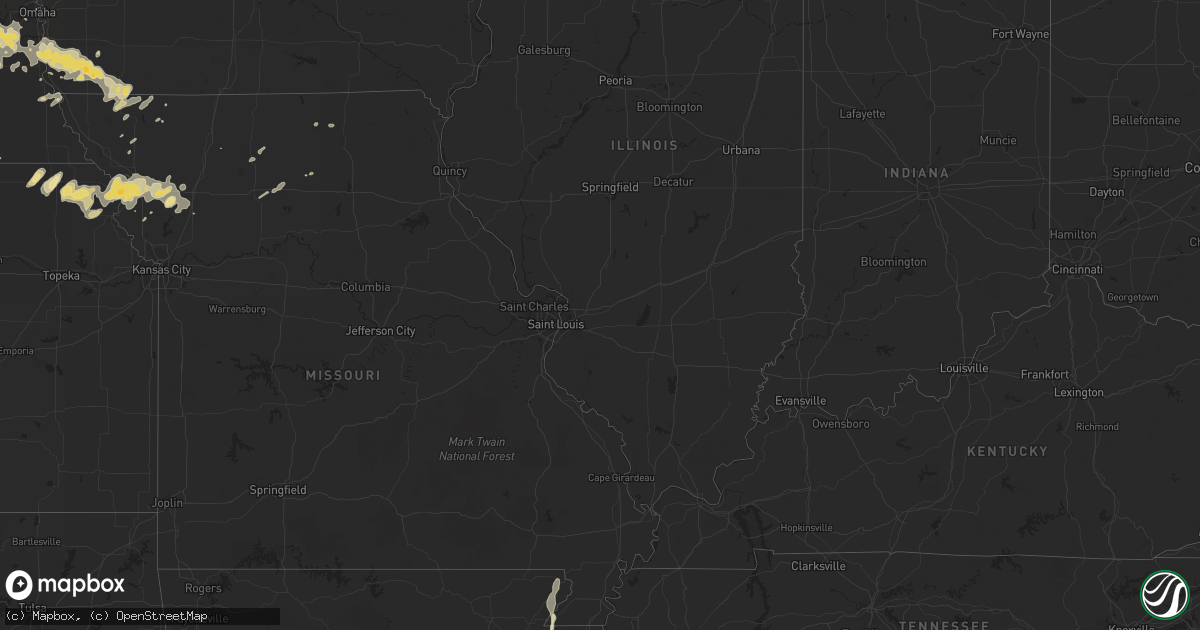
Hail Map in Minnesota on May 2, 2012
Get this storm
May 2 map
$229
one time, instant access
Download today. No call, no setup
Keep the $229
Bought the map and want the full workflow? Apply the entire $229 to a subscription within 7 days. None of it is wasted.
Every map, not just this one
This buys you this map. Subscription and you get every map we run, in the markets you choose from a few cities to whole states to nationwide. Plus real-time alerts the moment a storm fires.
Contact data
Name, contact info, occupancy, even credit band for addresses in the footprint. You go from where it hit to who to call.
Become the source they trust
Unlimited branding weather history reports on demand. You already have the documented answer ready for the property owner, and you are the one who showed up with it.
Property data and RoofTrace estimates
Pull up any address you have got, its value and the exact code rules for that jurisdiction, straight from One Click Code. Then RoofTrace estimates the squares, pitch, and roof value, priced the way you price.
Storm reports in Minnesota
Minnesota
| Date | Description |
|---|---|
| 05/02/20126:45 PM CDT | A local report indicates 2.50 inch wind near 2 N NORTH MANKATO |
| 05/02/20126:45 PM CDT | A local report indicates 1.00 inch wind near 2 S SPRINGFIELD |
| 05/02/20126:40 PM CDT | A local report indicates 2.00 inch wind near 2 N NORTH MANKATO |
| 05/02/20126:37 PM CDT | A local report indicates 1.00 inch wind near 2 NNE MANKATO |
| 05/02/20126:36 PM CDT | A local report indicates 1.25 inch wind near 2 WNW MANKATO |
| 05/02/20126:35 PM CDT | A local report indicates 1.25 inch wind near 3 WNW MANKATO |
| 05/02/20126:27 PM CDT | A local report indicates 1.25 inch wind near 3 WNW MANKATO |
| 05/02/20126:27 PM CDT | A local report indicates 1.00 inch wind near 4 WNW MANKATO |
| 05/02/20125:40 PM CDT | A local report indicates 1.00 inch wind near S HANSKA |
| 05/02/20126:30 AM CDT | Hail varied from moth ball to quarter in size. |
| 05/02/20126:28 AM CDT | 20 inch fork of large oak tree broken off at high school |
| 05/02/20126:21 AM CDT | Large amount of hail of mainly smaller then quarter size covering the ground. |
| 05/02/20121:26 AM CDT | A local report indicates 1.00 inch wind near LITCHFIELD |
| 05/02/20121:20 AM CDT | 10 trees snapped off and 2 trees uprooted at usace camp ground. Several other trees down on structures around area. |
| 05/02/20121:16 AM CDT | A local report indicates 1.00 inch wind near LITCHFIELD |
| 05/02/20121:03 AM CDT | A local report indicates 1.00 inch wind near 1 S GROVE CITY |
| 05/02/20121:00 AM CDT | Damaging thunderstorm winds tracked from the fish lake area into the west long lake area to near phelps mill. Several poplar trees were snapped... Some shingles and hou |
| 05/01/201210:50 PM CDT | A local report indicates 1.00 inch wind near 4 E HANCOCK |
| 05/01/201210:38 PM CDT | A local report indicates 1.00 inch wind near 3 NW WATSON |
| 05/01/201210:25 PM CDT | A local report indicates 1.25 inch wind near MILAN |
| 05/01/201210:08 PM CDT | A local report indicates 1.25 inch wind near 4 N CERRO GORDO |
| 05/01/20129:42 PM CDT | A local report indicates 1.50 inch wind near 4 NE NASSAU |
| 05/01/20129:29 PM CDT | Mndot site mn069 in kellogg on us hwy 61 |
| 05/01/20129:25 PM CDT | Mndot site mn069 on us hwy 61 |
| 05/01/20129:25 PM CDT | Trees down across city of wabasha |
| 05/01/20129:15 PM CDT | Cty rd 10 just outside of wabasha. 50 mph winds estimated as well. |
| 05/01/20129:15 PM CDT | A local report indicates 1.75 inch wind near 2 W WABASHA |
| 05/01/20129:14 PM CDT | A local report indicates 1.00 inch wind near 4 WNW WABASHA |
| 05/01/20128:45 PM CDT | A local report indicates 1.75 inch wind near 5 SW LAKE CITY |
| 05/01/20128:39 PM CDT | A local report indicates 1.00 inch wind near 5 S LAKE CITY |
| 05/01/20128:38 PM CDT | A local report indicates 1.75 inch wind near 2 NW OAK CENTER |
| 05/01/20128:33 PM CDT | A local report indicates 1.50 inch wind near 2 W OAK CENTER |
| 05/01/20128:30 PM CDT | A local report indicates 1.75 inch wind near 4 SW WANAMINGO |
| 05/01/20128:27 PM CDT | A local report indicates 1.00 inch wind near 6 S WANAMINGO |
| 05/01/20128:25 PM CDT | A local report indicates 1.00 inch wind near 2 NW BEAR VALLEY |
| 05/01/20128:00 PM CDT | A local report indicates 1.00 inch wind near 4 NE FARIBAULT |
| 05/01/20127:42 PM CDT | A local report indicates 1.00 inch wind near FARIBAULT |
| 05/01/20127:40 PM CDT | A local report indicates 1.00 inch wind near 3 W ZUMBROTA |
| 05/01/20127:36 PM CDT | A local report indicates 1.00 inch wind near 8 SW NEW ULM |
| 05/01/20127:36 PM CDT | A local report indicates 1.25 inch wind near 1 SW FARIBAULT |
| 05/01/20127:33 PM CDT | Delayed report..quarter size hail. Time estimated from radar. |
| 05/01/20127:32 PM CDT | A local report indicates 1.00 inch wind near 3 E PLAINVIEW |
| 05/01/20127:30 PM CDT | A local report indicates 1.00 inch wind near 3 NW MEDFORD |
| 05/01/20127:29 PM CDT | A local report indicates 1.00 inch wind near WARSAW |
| 05/01/20127:25 PM CDT | A local report indicates 1.00 inch wind near 3 NW MEDFORD |
| 05/01/20127:19 PM CDT | A local report indicates 1.00 inch wind near WASECA |
| 05/01/20127:15 PM CDT | Measured at eoc |
| 05/01/20127:10 PM CDT | A local report indicates 2.00 inch wind near 1 E WATERVILLE |
| 05/01/20127:09 PM CDT | A local report indicates 1.00 inch wind near 1 E WATERVILLE |
| 05/01/20127:08 PM CDT | A local report indicates 1.50 inch wind near 1 S WATERVILLE |
All States Impacted by Hail Map on May 2, 2012
Cities Impacted by Hail Map on May 2, 2012
- Reedsburg, WI
- Fergus Falls, MN
- Park Falls, WI
- Sheffield, PA
- Lindsay, NE
- Columbus, NE
- Albion, NE
- Dodge, NE
- Saint Edward, NE
- Creston, NE
- Rogers, NE
- Scribner, NE
- North Bend, NE
- Newman Grove, NE
- Leigh, NE
- Humphrey, NE
- Schuyler, NE
- Howells, NE
- Clarkson, NE
- Platte Center, NE
- Genoa, NE
- Fullerton, NE
- Silver Creek, NE
- Cumberland, WI
- Buffalo, MN
- Newland, NC
- Banner Elk, NC
- Amherst, NE
- Riverdale, NE
- Kearney, NE
- Linville, NC
- Elk Park, NC
- Winter, WI
- Rock Port, MO
- Aberdeen, MS
- Braddyville, IA
- Clearmont, MO
- Trumann, AR
- Bay, AR
- Jonesboro, AR
- Harrisburg, AR
- South Shore, SD
- Watertown, SD
- Stockholm, SD
- Bristol, SD
- Webster, SD
- Sparta, WI
- Fairview, KS
- Sabetha, KS
- Morrill, KS
- Marietta, MN
- Cedar Rapids, NE
- Everest, KS
- Robinson, KS
- Horton, KS
- Hiawatha, KS
- Powhattan, KS
- Kulm, ND
- Cogswell, ND
- Oakes, ND
- Emily, MN
- Prairie View, KS
- Greenville, MS
- Leland, MS
- New Albany, MS
- Kenyon, MN
- Faribault, MN
- North Collins, NY
- Lawtons, NY
- Hill City, KS
- Bogue, KS
- Palco, KS
- Peru, NE
- Eagle Lake, MN
- Waseca, MN
- Warsaw, MN
- Madison Lake, MN
- Morristown, MN
- Elysian, MN
- Waterville, MN
- Janesville, MN
- Effingham, KS
- Lancaster, KS
- Glenvil, NE
- Madison, MN
- Bellingham, MN
- Rosholt, WI
- Kane, PA
- James City, PA
- Ellis, KS
- Ogallah, KS
- Miltona, MN
- Eagle Bend, MN
- Clarissa, MN
- Bertha, MN
- Parkers Prairie, MN
- Cochrane, WI
- Fountain City, WI
- Saint Paul, NE
- Cameron, MO
- Osborn, MO
- Aurora, NE
- Stuart, VA
- Gettysburg, SD
- Agar, SD
- Anoka, MN
- Atwater, MN
- Grove City, MN
- Litchfield, MN
- Oto, IA
- Moville, IA
- Hornick, IA
- Anthon, IA
- Wood River, NE
- Kenesaw, NE
- Fredonia, ND
- Ripley, MS
- Blue Mountain, MS
- Haleyville, AL
- Custer, WI
- Wolbach, NE
- Randolph, IA
- Tabor, IA
- Imogene, IA
- Sidney, IA
- Farragut, IA
- Corry, PA
- Columbus, PA
- Spring Creek, PA
- Revillo, SD
- Kerkhoven, MN
- Willmar, MN
- Montevideo, MN
- Kandiyohi, MN
- Appleton, MN
- Raymond, MN
- Dawson, MN
- Darwin, MN
- Pennock, MN
- Clara City, MN
- Murdock, MN
- Maynard, MN
- Labolt, SD
- Milbank, SD
- Watson, MN
- Lake Lillian, MN
- Dassel, MN
- Milan, MN
- Delhi, LA
- Bedford, VA
- Thaxton, VA
- Belmond, IA
- Doniphan, NE
- Ridgway, PA
- Starbuck, MN
- Benson, MN
- Hastings, NE
- Juniata, NE
- Springfield, MN
- Sanborn, MN
- Battle Lake, MN
- Arcadia, WI
- Independence, WI
- Martinsburg, WV
- Dalton, MN
- Exeter, NE
- Napoleon, ND
- Kintyre, ND
- Wishek, ND
- Wittenberg, WI
- Norfolk, NE
- Clayton, WI
- Waucoma, IA
- Lawler, IA
- Ridgeway, IA
- Decorah, IA
- Calmar, IA
- Spillville, IA
- Fort Atkinson, IA
- Sac City, IA
- Lytton, IA
- Manistee, MI
- Free Soil, MI
- Holly Springs, MS
- Mankato, MN
- Dorchester, NE
- Hancock, MN
- Shenandoah, IA
- Shepherdstown, WV
- Angola, NY
- Belden, MS
- Saltillo, MS
- Tupelo, MS
- Tolstoy, SD
- Evart, MI
- Marion, MI
- Stewartsville, MO
- Plattsburg, MO
- Sinnamahoning, PA
- Zumbrota, MN
- Wanamingo, MN
- West Concord, MN
- Osseo, WI
- Minden, NE
- Upland, NE
- Hildreth, NE
- Saulsbury, TN
- Lanesboro, MN
- Lake City, AR
- Johnsonburg, PA
- Blowing Rock, NC
- Collettsville, NC
- Red Cloud, NE
- Blue Hill, NE
- Bladen, NE
- Inavale, NE
- Itta Bena, MS
- Moorhead, MS
- Burlington Junction, MO
- Blue Ridge, VA
- Montvale, VA
- Moneta, VA
- Greenwood, NE
- Belhaven, NC
- Trenton, MO
- Galt, MO
- Youngsville, PA
- Milford, NE
- Crete, NE
- Pleasant Dale, NE
- Lime Springs, IA
- Lehr, ND
- Fremont, NE
- Friend, NE
- Avon, MN
- Albany, MN
- Ashley, ND
- De Witt, IA
- Campbell, MN
- Fulton, MS
- Nettleton, MS
- Mora, MN
- Braham, MN
- Ogilvie, MN
- Ville Platte, LA
- Springville, NY
- Falmouth, MI
- McBain, MI
- Veblen, SD
- Lake City, MN
- Owatonna, MN
- Friendship, WI
- Stockton, KS
- Nelson, NE
- Edgar, NE
- Pittsville, WI
- Snyder, TX
- Ellendale, ND
- Fullerton, ND
- Girard, TX
- Nerstrand, MN
- Lake Crystal, MN
- Dalton, WI
- Trumbull, NE
- Plainview, MN
- Saint Charles, MN
- Skidmore, MO
- Maryville, MO
- Hague, ND
- Lewis Run, PA
- Rew, PA
- Gifford, PA
- Port Allegany, PA
- Smethport, PA
- Russell, PA
- Cyclone, PA
- Bradford, PA
- Osseo, MN
- Maple Grove, MN
- Dayton, MN
- Leroy, MI
- Conrath, WI
- Ladysmith, WI
- Forman, ND
- Nebraska City, NE
- Monticello, MN
- Elgin, ND
- Eureka, SD
- Bells, TN
- Alamo, TN
- Ashville, NY
- Mayville, NY
- Scranton, NC
- Pinetown, NC
- Whitehall, WI
- Blair, WI
- Spooner, WI
- Trego, WI
- Plymouth, NC
- Plantersville, MS
- Logan, KS
- Pantego, NC
- Edgeley, ND
- Linton, ND
- Westport, PA
- Renovo, PA
- Kimball, MN
- Lathrop, MO
- Roslyn, SD
- Manawa, WI
- Rockford, MN
- Hanover, MN
- Saint Michael, MN
- Loretto, MN
- Maple Lake, MN
- Randolph, NE
- Big Lake, MN
- Corona, SD
- Ortonville, MN
- Graceville, MN
- Clinton, MN
- Clay Center, NE
- Panama, IA
- Earling, IA
- Taylor, WI
- Cherokee, AL
- Black River Falls, WI
- Rector, AR
- Marmaduke, AR
- Bonifay, FL
- Ayr, NE
- Nashua, MN
- Henderson, NE
- Hampton, NE
- Garden City, SD
- Campbell, NE
- Wisconsin Rapids, WI
- Nekoosa, WI
- Irving, NY
- Pierce, NE
- Hoskins, NE
- Carroll, NE
- Northport, AL
- Waverly, NE
- Memphis, NE
- Ashland, NE
- Ithaca, NE
- Ceresco, NE
- Wallace, SD
- Bradley, SD
- Clarinda, IA
- Essex, IA
- Coin, IA
- Union, NE
- Glenwood, IA
- Plattsmouth, NE
- Elmo, MO
- Shambaugh, IA
- College Springs, IA
- Murray, NE
- Pacific Junction, IA
- Blanchard, IA
- Bedford, IA
- Thurman, IA
- Malvern, IA
- Heth, AR
- Robinsonville, MS
- Hughes, AR
- Reads Landing, MN
- Nelson, WI
- Mazeppa, MN
- Wabasha, MN
- Goodhue, MN
- Palmer, NE
- Nauvoo, AL
- Alma, WI
- Foreston, MN
- Milaca, MN
- Swanton, NE
- Western, NE
- Wilber, NE
- Mellwood, AR
- Strum, WI
- Eleva, WI
- Dannebrog, NE
- Hankinson, ND
- Oneida, KS
- Bern, KS
- Seneca, KS
- Hooper, NE
- Water Valley, MS
- Oxford, MS
- Taylor, MS
- Hayward, WI
- Whiting, IA
- Henning, MN
- Vining, MN
- Holstein, NE
- Roscoe, SD
- Remus, MI
- Mecosta, MI
- Osmond, NE
- Stirum, ND
- Easton, MO
- Peterson, MN
- Lincoln, NE
- Gretna, NE
- Grafton, NE
- Davey, NE
- Fairfield, NE
- Lawrence, NE
- Seward, NE
- Superior, NE
- Raymond, NE
- Ong, NE
- Fairmont, NE
- Ohiowa, NE
- Saronville, NE
- Springfield, NE
- Louisville, NE
- Beaver Crossing, NE
- South Bend, NE
- Davenport, NE
- Sutton, NE
- Giltner, NE
- Eagle, NE
- Milligan, NE
- Deweese, NE
- Murdock, NE
- Denton, NE
- Elmwood, NE
- Alvo, NE
- Shickley, NE
- Oak, NE
- Yutan, NE
- Malcolm, NE
- Walton, NE
- Harvard, NE
- Wahoo, NE
- Geneva, NE
- Roseland, NE
- Inland, NE
- Meadville, MO
- Rogers, MN
- Elk River, MN
- Omaha, NE
- Blue Springs, MS
- Stanberry, MO
- Mabel, MN
- Canton, MN
- Damar, KS
- Lenora, KS
- Alliance, OH
- Sebring, OH
- Franklin, NE
- Manley, NE
- Hastings, IA
- Yorktown, IA
- Guide Rock, NE
- Waterloo, NE
- Weeping Water, NE
- Garland, NE
- Strang, NE
- Nehawka, NE
- Hopkins, MO
- Tobias, NE
- Papillion, NE
- Riverton, IA
- Westboro, MO
- Avoca, NE
- New Market, IA
- Percival, IA
- Greenway, AR
- Piggott, AR
- Fairfield, NC
- Swanquarter, NC
- Carson, ND
- Galeton, PA
- Mahaffey, PA
- Punxsutawney, PA
- Sherman, NY
- New Auburn, WI
- Cresco, IA
- Conde, SD
- Oregon, MO
- Clarksdale, MO
- Elwood, KS
- Troy, KS
- Saint Joseph, MO
- Savannah, MO
- Cosby, MO
- Bendena, KS
- Wathena, KS
- Browerville, MN
- Brandon, MN
- Evansville, MN
- Ashby, MN
- Garfield, MN
- Clitherall, MN
- Glenwood, MN
- Arbyrd, MO
- Leachville, AR
- Cardwell, MO
- Solen, ND
- Osakis, MN
- Nelson, MN
- Morris, MN
- Chokio, MN
- Somerville, TN
- Annandale, MN
- Henry, VA
- Concord, NE
- Allen, NE
- Custer, MI
- Fountain, MI
- Scottville, MI
- Ogdensburg, WI
- Talmage, NE
- Julian, NE
- Westside, IA
- Wattsburg, PA
- Clymer, NY
- Clarendon, PA
- South Haven, MN
- Clearwater, MN
- Clarksdale, MS
- Madison, NE
- Florence, SD
- Brookfield, MO
- New Boston, MO
- Persia, IA
- Logan, IA
- Homer, NE
- Hubbard, NE
- Plainville, KS
- Dumont, MN
- Pine Island, MN
- Storden, MN
- Saint Clair, MN
- Comfrey, MN
- Zumbro Falls, MN
- Merrillan, WI
- Hixton, WI
- Saint James, MN
- Cleveland, MN
- Sleepy Eye, MN
- Kasota, MN
- Millville, MN
- Medford, MN
- Kellogg, MN
- New Ulm, MN
- Neillsville, WI
- Eyota, MN
- Dover, MN
- Altura, MN
- Madelia, MN
- Hanska, MN
- Lamberton, MN
- Pepin, WI
- Mondovi, WI
- Jeffers, MN
- Denton, KS
- Camden, MS
- Stow, NY
- Bemus Point, NY
- Shell Lake, WI
- Barronett, WI
- Gower, MO
- Tustin, MI
- Breckenridge, MN
- Shannon, MS
- Sturgis, MS
- Red Oak, IA
- Oshkosh, WI
- Clontarf, MN
- Alberta, MN
- Holloway, MN
- Danvers, MN
- Belgrade, NE
- Sheridan, MO
- Harrison, MI
- Townley, AL
- Oakman, AL
- Raymond, SD
- Braddock, ND
- Hazelton, ND
- Wahpeton, ND
- Underwood, MN
- Meadow Grove, NE
- Wetmore, KS
- Tomah, WI
- Lovettsville, VA
- Andover, SD
- Sarona, WI
- Humbird, WI
- Berlin, WI
- Omro, WI
- Brimson, MN
- Poplar Grove, AR
- Lexa, AR
- Outing, MN
- Green Castle, MO
- Cairo, NE
- Gwinner, ND
- Forbes, ND
- Ferrum, VA
- Chillicothe, MO
- Paragould, AR
- Pender, NE
- Thurston, NE
- Walthill, NE
- Baraboo, WI
- Holstein, IA
- Cushing, IA
- Elma, IA
- Breda, IA
- Siren, WI
- Frederic, WI
- Latimer, IA
- Alexander, IA
- Harcourt, IA
- Laurel, NE
- Ludington, MI
- Webster, WI
- Canton, NC
- Atchison, KS
- Boone, NC
- Rice Lake, WI
- Hale, MI
- Champlin, MN
- Minneapolis, MN
- Andover, MN
- Spur, TX
- Nashua, IA
- Rockwell City, IA
- Saint Marys, PA
- Lake Providence, LA
- Lisbon, OH
- Salineville, OH
- Fairmount, ND
- Carroll, IA
- Gilman City, MO
- New Hampton, IA
- Cadillac, MI
- Harlan, IA
- Magnet, NE
- Branch, MI
- Rutland, ND
- Hodges, AL
- Glidden, IA
- Bolckow, MO
- Marienville, PA
- Cordova, NE
- Louisville, MS
- Ackerman, MS
- Monroe, NE
- Baldwin, MI
- Luther, MI
- Grand Junction, TN
- Lake City, IA
- Flasher, ND
- Lorman, MS
- Big Run, PA
- Reynoldsville, PA
- Raleigh, ND
- Shields, ND
- Beaumont, MS
- New Augusta, MS
- Winneconne, WI
- Markesan, WI
- Driftwood, PA
- Emporium, PA
- La Crosse, WI
- Faucett, MO
- Ames, NE
- Grantsburg, WI
- Two Rivers, WI
- Kinder, LA
- Guntown, MS
- Dearborn, MO
- Agency, MO
- Carbon Hill, AL
- Waupaca, WI
- Battle Creek, NE
- Cameron, WI
- Wilcox, PA
- Missouri Valley, IA
- Bolton, MS
- Shelby, IA
- Nickerson, NE
- Smithland, IA
- Onawa, IA
- Rodney, IA
- Graham, MO
- Stephens City, VA
- Barron, WI
- Elrod, AL
- Gordo, AL
- Shelton, NE
- Gibbon, NE
- Eldridge, AL
- Lynn, AL
- Tallulah, LA
- Barnard, MO
- Sauk Rapids, MN
- Mclean, NE
- Watkins, MN
- Donahue, IA
- Austin, PA
- Long Lake, SD
- Stockholm, WI
- Ettrick, WI
- Paris, VA
- Auburn, IA
- Minter City, MS
- Fifty Lakes, MN
- Westville, FL
- Willis, VA
- Meadows Of Dan, VA
- Harrisonburg, LA
- Warrens, WI
- Vail, IA
- Manson, IA
- Palmer, IA
- Gonzales, LA
- Geismar, LA
- Darrow, LA
- Alma Center, WI
- Burchard, NE
- Primrose, NE
- Frewsburg, NY
- Vinton, VA
- Lake City, MI
- Hersey, MI
- Reed City, MI
- Washington, LA
- Bunkie, LA
- Morrow, LA
- Mooreton, ND
- Rayville, LA
- Tilden, NE
- Wynne, AR
- De Kalb, MO
- Amazonia, MO
- Berry, AL
- Franklin, AL
- Whatley, AL
- Waterbury, NE
- Cambridge, MN
- Tidioute, PA
- Gladwin, MI
- Chase, MI
- Norwalk, WI
- Deer Creek, MN
- Butternut, WI
- Hilbert, WI
- Beech Creek, PA
- Red Bay, AL
- Wayne, NE
- Dennis, MS
- Portsmouth, IA
- Guin, AL
- Earle, AR
- Irons, MI
- Clarksville, IA
- Saint Landry, LA
- Phillipsburg, KS
- Moss Point, MS
- Pine City, MN
- Verona, MS
- Amity, MO
- Turney, MO
- Princeton, MN
- Benezett, PA
- Wakefield, NE
- Pittsfield, PA
- Grand Valley, PA
- Winslow, NE
- Hertel, WI
- Necedah, WI
- Hickory Flat, MS
- Becker, MN
- Palmetto, LA
- Wilmer, AL
- Lucedale, MS
- Pomeroy, IA
- Jolley, IA
- Fonda, IA
- Ionia, IA
- Brillion, WI
- Fayette, MS
- Ravenwood, MO
- Novinger, MO
- Weyauwega, WI
- Clark, SD
- Semmes, AL
- Granton, WI
- Sharpsburg, MD
- Chicora, PA
- Wisconsin Dells, WI
- Winchester, VA
- Ottertail, MN
- Pickering, MO
- Randolph, WI
- Cambria, WI
- Montello, WI
- Malone, WI
- Chilton, WI
- Merritt, MI
- Doland, SD
- Panama, NY
- Toone, TN
- Medon, TN
- Saint Libory, NE
- Eden, NY
- Martinsville, VA
- Bassett, VA
- Zeeland, ND
- Nicollet, MN
- Saint Peter, MN


