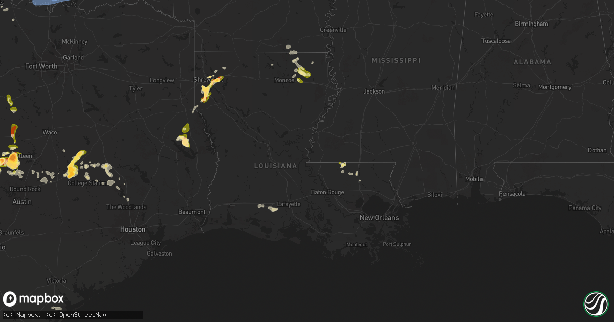
Hail Map in Louisiana on May 1, 2025
Get this storm
May 1 map
$229
one time, instant access
Download today. No call, no setup
Keep the $229
Bought the map and want the full workflow? Apply the entire $229 to a subscription within 7 days. None of it is wasted.
Every map, not just this one
This buys you this map. Subscription and you get every map we run, in the markets you choose from a few cities to whole states to nationwide. Plus real-time alerts the moment a storm fires.
Contact data
Name, contact info, occupancy, even credit band for addresses in the footprint. You go from where it hit to who to call.
Become the source they trust
Unlimited branding weather history reports on demand. You already have the documented answer ready for the property owner, and you are the one who showed up with it.
Property data and RoofTrace estimates
Pull up any address you have got, its value and the exact code rules for that jurisdiction, straight from One Click Code. Then RoofTrace estimates the squares, pitch, and roof value, priced the way you price.
Storm reports in Louisiana
Louisiana
| Date | Description |
|---|---|
| 05/01/20256:46 PM CDT | Ping pong ball to golf ball size hail fell in the plantation hills subdivision. |
| 05/01/20256:46 PM CDT | Ping pong ball to golfball size hail fell in the plantation hills subdivision. |
| 05/01/20256:45 PM CDT | Off of long rd... South of red bluff rd. |
| 05/01/20256:01 PM CDT | Sherrifs office reported quarter sized hail along hwy 961... 3 miles north of hwy 10 in east feliciana parish. |
| 05/01/20254:25 PM CDT | Numerous large limbs down and broken sections of trees in nw morehouse. |
| 04/30/202511:59 PM CDT | A local report indicates 1.00 inch wind near 1 ENE Rayville |
| 04/30/202510:00 PM CDT | In the holly ridge community. |
| 04/30/20259:40 PM CDT | A local report indicates 1.00 inch wind near 4 ENE Oak Ridge |
| 04/30/20259:15 PM CDT | In addition to the hail... A couple of trees had large sections of them blown out. |
| 04/30/20258:05 PM CDT | A local report indicates 1.00 inch wind near Mer Rouge |
| 04/30/20257:41 PM CDT | Report via mping. Started off with ping pongs and turned into golf balls. |
| 04/30/20257:27 PM CDT | Report of half dollar size hail in the southgate estates area. |
| 04/30/20257:25 PM CDT | A picture of golfball size hail that fell near sun city elementary in bossier city was posted to social media. |
| 04/30/20257:12 PM CDT | Report from mping of 1 inch hail. |
| 04/30/20257:04 PM CDT | Subdivision off norris ferry road. |
All States Impacted by Hail Map on May 1, 2025
Cities Impacted by Hail Map on May 1, 2025
- Jennings, LA
- Morse, LA
- Mermentau, LA
- Crowley, LA
- Kaplan, LA
- Rayne, LA
- Warsaw, VA
- Farnham, VA
- Callao, VA
- Bainbridge, OH
- Hillsboro, OH
- Solon, OH
- Chagrin Falls, OH
- Cochranton, PA
- Meadville, PA
- Cleveland, OH
- Northfield, OH
- Macedonia, OH
- Independence, OH
- Beachwood, OH
- Bedford, OH
- Gates Mills, OH
- Euclid, OH
- Westernport, MD
- Bloomington, MD
- Willoughby, OH
- Wickliffe, OH
- Guys Mills, PA
- Townville, PA
- Novelty, OH
- Lonaconing, MD
- Barton, MD
- Frostburg, MD
- Rawlings, MD
- Centerville, PA
- Copperas Cove, TX
- Cumberland, MD
- Ridgeley, WV
- Gatesville, TX
- Wiley Ford, WV
- Oldtown, MD
- Flintstone, MD
- Mentor, OH
- Kempner, TX
- Fort Hood, TX
- Killeen, TX
- Chireno, TX
- Rocksprings, TX
- Burnet, TX
- Buchanan Dam, TX
- Kingsland, TX
- Purmela, TX
- Bluffton, TX
- Tow, TX
- Fort Ashby, WV
- Keyser, WV
- Hearne, TX
- Cameron, TX
- Reagan, TX
- Alhambra, IL
- Little Orleans, MD
- Artemas, PA
- Clearville, PA
- Springfield, WV
- Elizabeth, AR
- Calvert, TX
- Pocahontas, IL
- San Augustine, TX
- Highland, IL
- Bastrop, LA
- Sorento, IL
- Warfordsburg, PA
- Jonesboro, TX
- Greenville, IL
- Dryden, TX
- Comstock, TX
- Watson, IL
- Mason, IL
- Briggs, TX
- Mountain Home, TX
- Crossett, AR
- Viola, AR
- Barksdale, TX
- Franklin, TX
- Oak Grove, LA
- Needmore, PA
- Lampasas, TX
- Salem, AR
- Big Cove Tannery, PA
- Hancock, MD
- McConnellsburg, PA
- Calhoun City, MS
- Pittsboro, MS
- Center, TX
- Mason, TX
- Vardaman, MS
- Carlyle, IL
- Hico, TX
- Solano, NM
- Mosquero, NM
- Ava, IL
- Rockwood, IL
- Bruceton Mills, WV
- Gore Springs, MS
- Big Creek, MS
- Bryan, TX
- Chester, IL
- Campbell Hill, IL
- Murphysboro, IL
- West Point, MS
- Aberdeen, MS
- Junction, TX
- Florence, TX
- Broaddus, TX
- Uvalde, TX
- Roy, NM
- Mill Run, PA
- Iredell, TX
- Vergennes, IL
- Houston, MS
- Okolona, MS
- Clayton, NM
- Grenville, NM
- Sedan, NM
- Texline, TX
- De Soto, IL
- Royalton, IL
- Mulkeytown, IL
- Zeigler, IL
- West Frankfort, IL
- Brackettville, TX
- Gause, TX
- Winona, MO
- Alton, MO
- Rockwood, PA
- Joaquin, TX
- Frisco City, AL
- Monroeville, AL
- Elkville, IL
- Garrett, PA
- Festus, MO
- Bloomsdale, MO
- Derma, MS
- Markleysburg, PA
- Confluence, PA
- Liberty Hill, TX
- Bertram, TX
- Bremond, TX
- Dalhart, TX
- Orient, IL
- Clinton, LA
- Greensburg, LA
- Ozona, TX
- Stephenville, TX
- Perryville, MO
- Uniontown, MO
- Grenada, MS
- Logansport, LA
- Holcomb, MS
- Peterman, AL
- London, TX
- Norwood, LA
- Fremont, MO
- Van Buren, MO
- Carterville, IL
- Carbondale, IL
- Somerset, PA
- Conchas Dam, NM
- Frohna, MO
- Oak Ridge, MO
- Altenburg, MO
- Milano, TX
- Carrollton, MS
- Greenwood, MS
- Del Rio, TX
- Cambria, IL
- Marion, IL
- Herrin, IL
- Energy, IL
- Grandin, MO
- Ellsinore, MO
- Ellington, MO
- Jackson, MO
- Old Appleton, MO
- Normangee, TX
- North Zulch, TX
- Keatchie, LA
- South Fork, PA
- Johnstown, PA
- Hollsopple, PA
- Davidsville, PA
- Windber, PA
- Hooversville, PA
- Madisonville, TX
- Sonora, TX
- Johnston City, IL
- Pittsburg, IL
- New Florence, PA
- Caldwell, TX
- Gloster, LA
- Grand Cane, LA
- Thompsonville, IL
- Seanor, PA
- Mineral Point, PA
- Breezewood, PA
- Crystal Spring, PA
- Frierson, LA
- Keithville, LA
- Stonewall, LA
- Shreveport, LA
- Tucumcari, NM
- Hamburg, AR
- Alto Pass, IL
- Johnsonville, IL
- McCarley, MS
- Harrisburg, IL
- Galatia, IL
- Cisne, IL
- Boswell, PA
- Georgetown, TX
- Wolf Lake, IL
- Duck Hill, MS
- Eldorado, TX
- Cobden, IL
- San Jon, NM
- Bossier City, LA
- Beatrice, AL
- Jonesboro, IL
- Bedias, TX
- Summerhill, PA
- Harrisonville, PA
- Farmerville, LA
- Brady, TX
- Huntsville, TX
- Marble Falls, TX
- Wellington, AL
- Ohatchee, AL
- Cherokee, TX
- Bronson, TX
- Neelyton, PA
- Burnt Cabins, PA
- Shade Gap, PA
- San Saba, TX
- Upperstrasburg, PA
- Fannettsburg, PA
- Haughton, LA
- Menard, TX
- Woodstock, AL
- West Blocton, AL
- Vance, AL
- Rochelle, TX
- Doyline, LA
- Princeton, LA
- Minden, LA
- Crystal City, TX
- Amite, LA
- Amory, MS
- Richards, TX
- Walnut Ridge, AR
- Bono, AR
- Summit, MS
- Iola, TX
- Lometa, TX
- Leeds, AL
- Birmingham, AL
- Batesville, TX
- Anderson, TX
- Buckholts, TX
- Davilla, TX
- Sabinal, TX
- Goldthwaite, TX
- Hext, TX
- Montgomery, TX
- Mount Carmel, IL
- Concan, TX
- Pomona, IL
- College Station, TX
- Roseland, LA
- Jonesboro, AR
- New Waverly, TX
- Spring Run, PA
- La Pryor, TX
- Magnolia, MS
- Bend, TX
- Princeton, IN
- Fredonia, TX
- Owensville, IN
- Bartlett, TX
- Rockdale, TX
- Cotton Valley, LA
- Fluker, LA
- Conroe, TX
- Granger, TX
- Mer Rouge, LA
- Alicia, AR
- Salado, TX
- Jarrell, TX
- Oakland City, IN
- Francisco, IN
- Oak Ridge, LA
- Thorndale, TX
- Taylor, TX
- Stonefort, IL
- Simpson, IL
- Ozark, IL
- Rayville, LA
- Pioneer, LA
- Vega, TX
- Thrall, TX
- Utopia, TX
- Makanda, IL
- Buncombe, IL
- Fort Loudon, PA
- D Hanis, TX
- Dry Run, PA
- Doylesburg, PA
- Hereford, TX
- Goreville, IL
- Tylertown, MS
- Mccomb, MS
- Carrizo Springs, TX
- Asherton, TX
- Independence, LA
- Epps, LA
- Delhi, LA
- Hustontown, PA
- Skellytown, TX
- Miami, TX
- Happy, TX
- Canyon, TX
- Laredo, TX
- Llano, CA
- Pearblossom, CA
- Tulia, TX
- Collinston, LA
- Pampa, TX
- Canadian, TX
- Osyka, MS
- Big Wells, TX
- Wheeler, TX
- Jayess, MS
- Silverton, TX
- Claude, TX
- Wayside, TX
- Briscoe, TX
- Sweetwater, OK
- Matador, TX
- Turkey, TX
- Quitaque, TX
- Vernon, TX
- Chillicothe, TX
- Elk City, OK
- Quanah, TX
- Frederick, OK
- Loveland, OK
- Canute, OK
- Paducah, TX
- Hollister, OK
- Elmer, OK
- Cache, OK
- Faxon, OK
- Chattanooga, OK
- Butler, OK
- Childress, TX
- Tipton, OK
- Eldorado, OK
- Odell, TX
- Mangum, OK
- Walters, OK
- Granite, OK
- Lone Wolf, OK
- Davidson, OK
- Grandfield, OK
- Cordell, OK
- Graham, OK
- Ratliff City, OK
- Devol, OK
- Lawton, OK
- Fort Sill, OK
- Honobia, OK
- Heavener, OK
- Duncan, OK
- Elmore City, OK
- Geronimo, OK
- Randlett, OK
- Wister, OK
- Howe, OK
- Healdton, OK
- Pauls Valley, OK
- Wynnewood, OK
- Oklaunion, TX
- Hartford, AR
- Temple, OK
- Comanche, OK
- Stratford, OK
- Mansfield, AR
- Anadarko, OK
- Harrold, TX
- Hennepin, OK
- Poteau, OK
- Ada, OK
- Tussy, OK
- Huntington, AR
- Electra, TX
- Cement, OK
- Mcalester, OK
- Wichita Falls, TX
- Konawa, OK
- Foster, OK
- Lonoke, AR
- Byars, OK
- Hackett, AR
- Cameron, OK
- Manchester, TN
- Chickasha, OK
- Ninnekah, OK
- Indianola, OK
- Burkburnett, TX
- Danville, AR
- Booneville, AR
- Dardanelle, AR
- Greenwood, AR
- Fort Smith, AR
- Petrolia, TX
- Havana, AR
- Byers, TX
- Waurika, OK
- Paris, AR
- Holdenville, OK
- Asher, OK
- Ryan, OK
- Sheppard Afb, TX
- Biscoe, AR
- Morrilton, AR
- Belleville, AR
- Maud, OK
- Magazine, AR
- Brinkley, AR
- Conway, AR
- Plumerville, AR
- Stigler, OK
- Hattieville, AR
- Henrietta, TX
- Allen, OK
- Greenbrier, AR
- Center Ridge, AR
- Springfield, AR
- Bellevue, TX
- Checotah, OK
- Porum, OK
- Guy, AR
- Rockport, TX
- Altus, AR
- Clarksville, AR
- Coal Hill, AR
- Burneyville, OK
- Marietta, OK
- Leon, OK
- Houston, AR
- Hartman, AR
- Bowie, TX
- Quinton, OK
- Gainesville, TX
- Wilson, OK
- Saint Jo, TX
- Overbrook, OK
- Madill, OK
- Kingston, OK
- Lebanon, OK
- Whitesboro, TX
- Higden, AR
- Romance, AR
- Vian, OK
- Headrick, OK
- Quitman, AR
- Damascus, AR
- Altus, OK
- Fairfield Bay, AR
- Olustee, OK
- Edgemont, AR
- Enola, AR
- Cookson, OK
- Park Hill, OK
- Wooster, AR
- Ponca, AR
- Mountain View, AR
- Prim, AR
- Deer, AR
- Rose Bud, AR
- Mount Vernon, AR
- Mccurtain, OK
- Parthenon, AR
- Jasper, AR
- Searcy, AR
- Bokoshe, OK
- Milburn, OK
- Coleman, OK
- Tishomingo, OK
- Wapanucka, OK
- Mead, OK
- Durant, OK
- Kenefic, OK
- Calera, OK
- Ardmore, OK
- Caddo, OK
- Atoka, OK
- Marble Falls, AR
- Shady Point, OK
- Timbo, AR
- Roland, AR
- Spiro, OK
- Pocola, OK
- North Little Rock, AR
- Mayflower, AR
- Beebe, AR
- Memphis, TN
- Judsonia, AR
- Bald Knob, AR
- Charleston, AR
- Arkoma, OK
- Maumelle, AR
- Lavaca, AR
- Sherwood, AR
- Jacksonville, AR
- Grady, NM
- Van Buren, AR
- Barling, AR
- Scranton, AR
- Vilonia, AR
- Cabot, AR
- Arlington, TN
- Little Rock Air Force Base, AR
- Austin, AR
- Ward, AR
- Eads, TN
- Augusta, AR
- McCrory, AR
- Newport, AR
- Hickory Ridge, AR
- Fisher, AR
- Subiaco, AR
- Millington, TN
- Ozark, AR
- Oakland, TN
- Somerville, TN
- Atoka, TN
- Brighton, TN
- Barksdale Afb, LA
- Sayre, OK
- Carter, OK
- Dill City, OK
- Arapaho, OK
- Foss, OK
- Clinton, OK
- Bessie, OK
- Corn, OK
- Weatherford, OK


