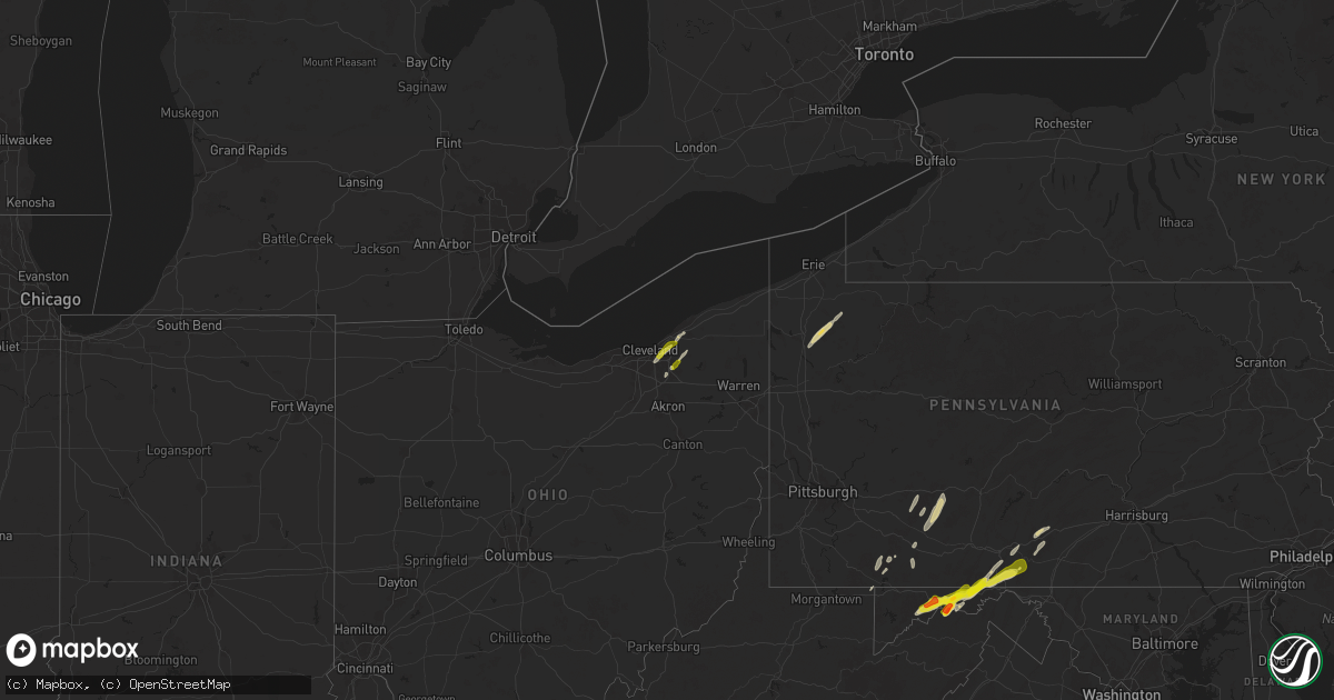
Hail Map on May 1, 2025
Get this storm
May 1 map
$229
one time, instant access
Download today. No call, no setup
Keep the $229
Bought the map and want the full workflow? Apply the entire $229 to a subscription within 7 days. None of it is wasted.
Every map, not just this one
This buys you this map. Subscription and you get every map we run, in the markets you choose from a few cities to whole states to nationwide. Plus real-time alerts the moment a storm fires.
Contact data
Name, contact info, occupancy, even credit band for addresses in the footprint. You go from where it hit to who to call.
Become the source they trust
Unlimited branding weather history reports on demand. You already have the documented answer ready for the property owner, and you are the one who showed up with it.
Property data and RoofTrace estimates
Pull up any address you have got, its value and the exact code rules for that jurisdiction, straight from One Click Code. Then RoofTrace estimates the squares, pitch, and roof value, priced the way you price.
States Impacted by Hail Map on May 1, 2025
Storm reports
Mississippi
| Date | Description |
|---|---|
| 05/01/20256:00 PM CDT | Ping pong ball size hail in holcomb ms. |
| 05/01/20255:07 PM CDT | A local report indicates 1.00 inch wind near 1 NNE Calhoun City |
Wyoming
| Date | Description |
|---|---|
| 05/01/20256:00 PM CDT | Mesonet station gw1458 buffalo; convective shower... But no lightning present. |
| 05/01/20255:59 PM CDT | Asos station kbyg buffalo airport; convective rain shower with no lightning present. |
West Virginia
| Date | Description |
|---|---|
| 05/01/20254:38 PM CDT | Tree down on river road. |
| 05/01/20254:25 PM CDT | Tree down on route 92. |
| 05/01/20254:21 PM CDT | Multiple trees down in the area of patterson creek. |
Louisiana
| Date | Description |
|---|---|
| 05/01/20256:46 PM CDT | Ping pong ball to golfball size hail fell in the plantation hills subdivision. |
| 05/01/20256:46 PM CDT | Ping pong ball to golf ball size hail fell in the plantation hills subdivision. |
| 05/01/20256:45 PM CDT | Off of long rd... South of red bluff rd. |
| 05/01/20256:01 PM CDT | Sherrifs office reported quarter sized hail along hwy 961... 3 miles north of hwy 10 in east feliciana parish. |
| 05/01/20254:25 PM CDT | Numerous large limbs down and broken sections of trees in nw morehouse. |
| 04/30/202511:59 PM CDT | A local report indicates 1.00 inch wind near 1 ENE Rayville |
| 04/30/202510:00 PM CDT | In the holly ridge community. |
| 04/30/20259:40 PM CDT | A local report indicates 1.00 inch wind near 4 ENE Oak Ridge |
| 04/30/20259:15 PM CDT | In addition to the hail... A couple of trees had large sections of them blown out. |
| 04/30/20258:05 PM CDT | A local report indicates 1.00 inch wind near Mer Rouge |
| 04/30/20257:41 PM CDT | Report via mping. Started off with ping pongs and turned into golf balls. |
| 04/30/20257:27 PM CDT | Report of half dollar size hail in the southgate estates area. |
| 04/30/20257:25 PM CDT | A picture of golfball size hail that fell near sun city elementary in bossier city was posted to social media. |
| 04/30/20257:12 PM CDT | Report from mping of 1 inch hail. |
| 04/30/20257:04 PM CDT | Subdivision off norris ferry road. |
Pennsylvania
| Date | Description |
|---|---|
| 05/01/20256:50 PM CDT | Trees and wires down along the 3700 block of glendale blvd just south of coalport. |
| 05/01/20256:39 PM CDT | A roof was blown off a barn in the 1100 block of schoolhouse road east of chest springs. |
| 05/01/20256:34 PM CDT | A one story wood storage building was destroyed in the 1100 block of columbia street in allegheny township north of loretto. |
| 05/01/20256:20 PM CDT | Wires down on psp cruiser. |
| 05/01/20256:07 PM CDT | Numerous reports of trees and wires down on the west and south side of johnstown from brownstown to westmont to southmont to ferndale. |
| 05/01/20256:07 PM CDT | Trees and wires down near the intersection of diamond blvd and susan drive in southmont. |
| 05/01/20256:05 PM CDT | Trees and wires down in the 600 block of eisenhower blvd just south of geistown. |
| 05/01/20255:53 PM CDT | Tree and possibly wires down near intersection of clay hill road and four seasons road near boswell. |
| 05/01/20255:35 PM CDT | Tree down on nebo road. |
| 05/01/20255:33 PM CDT | Trees down in the normalville area. |
| 05/01/20255:32 PM CDT | Trees down in the mill run area. |
| 05/01/20255:30 PM CDT | Tree and possibly wires down across scullton road near the intersection with whipkey dam road... Blocking most of roadway. |
| 05/01/20255:30 PM CDT | Wires down near the intersection of scullton road and hilltop drive just west of new lexington. |
| 05/01/20254:28 PM CDT | Medium sized tree down at buffalo rd and iroquois ave. Time estimated via radar. |
| 05/01/20254:07 PM CDT | Large tree branch down. |
| 05/01/20252:50 PM CDT | Crawford county pa ema reports trees and wires down in athens and sparta townships. Time estimated via radar. |
| 04/30/20257:11 PM CDT | Route 350 was closed south of philipsburg between sleepy hollow road and miller road due to trees and wires down. |
Alabama
| Date | Description |
|---|---|
| 05/01/20255:55 PM CDT | Photos of 1.5 to almost 2.0 inch hail in the peterman community. Photo was taken with the hail measured against a ruler. Photos via social media. |
| 05/01/20255:47 PM CDT | Numerous photos and videos of 1+ inch hail in monroeville. Photos and videos via social media. |
| 05/01/20255:31 PM CDT | Tree down along hwy 71. |
| 05/01/20255:22 PM CDT | Tree and power lines down. |
| 05/01/20255:20 PM CDT | Tree down in roadway near al hwy 117 and cr 14. |
| 05/01/20255:07 PM CDT | Tree down in roadway on cr 21. Time estimated from radar. |
| 05/01/20255:02 PM CDT | Corrects previous tstm wnd dmg report from 6 nw scottsboro. Tree and power lines down. Time estimated from radar. |
| 05/01/20255:02 PM CDT | Tree down that may have led to power outages in scottsboro. |
Virginia
| Date | Description |
|---|---|
| 05/01/20253:24 PM CDT | One tree down on sage road. |
| 05/01/20253:24 PM CDT | One tree down on sage road. |
| 05/01/20252:29 PM CDT | 50 mph wind gust recorded on personal weather station. |
Missouri
| Date | Description |
|---|---|
| 05/01/20256:15 PM CDT | A local report indicates 1.00 inch wind near Van Buren |
| 05/01/20256:00 PM CDT | Nickel up to quarter size hail in fremont. |
Arkansas
| Date | Description |
|---|---|
| 05/01/20255:57 AM CDT | A local report indicates 1.00 inch wind near Excelsior |
| 05/01/20255:57 AM CDT | Tree down. |
| 05/01/20254:49 AM CDT | A local report indicates 1.25 inch wind near Wooster |
| 05/01/20253:50 AM CDT | Report from mping: quarter |
| 05/01/20253:46 AM CDT | A local report indicates 1.00 inch wind near 1 W Catholic Point |
Ohio
| Date | Description |
|---|---|
| 05/01/20255:00 PM CDT | Report of two trees down in girard. |
| 05/01/20254:12 PM CDT | Trees and wires downed in the louisville area. |
| 05/01/20254:00 PM CDT | Delayed report of 18 foot long branch down... A foot in diameter. Time estimated by radar. |
| 05/01/20253:28 PM CDT | Ashtabula county ema reported trees down in the areas of roaming shores... Morgan township... And jefferson. Time estimated via radar. |
| 05/01/20253:18 PM CDT | Trees down on county road 25 |
| 05/01/20253:05 PM CDT | Wall collapsed onto sidewalk. |
| 05/01/20252:58 PM CDT | Tree snapped and fell on a power line... Knocking out power in the area. |
| 05/01/20252:43 PM CDT | Large tree down on house. |
| 05/01/20252:42 PM CDT | Tree downed along west jackson street in painesville twp. |
| 05/01/20252:38 PM CDT | Tree downed onto house... Causing structural damage. No injuries reported. |
| 05/01/20252:36 PM CDT | Public report of trees snapped. |
| 05/01/20252:33 PM CDT | Large tree limb downed. |
| 05/01/20252:29 PM CDT | Tree limbs and a wire downed in north ridgeville. |
| 05/01/20252:29 PM CDT | Tree downed on hobart rd. |
| 05/01/20252:28 PM CDT | A local report indicates 1.25 inch wind near Highland Heights |
| 05/01/20252:23 PM CDT | A number of pea sized stones with a few as large as quarter sized. |
| 05/01/20252:23 PM CDT | A local report indicates 1.00 inch wind near 1 SW Mayfield |
| 05/01/20252:21 PM CDT | Healthy 8 inch diameter tree snapped... Landing on top of a detached garage. |
| 05/01/20252:19 PM CDT | Public report on social media. |
| 05/01/20252:19 PM CDT | Report from mping: quarter |
| 05/01/20252:15 PM CDT | A local report indicates 1.00 inch wind near 2 SSE Bedford Heights |
| 05/01/20252:14 PM CDT | A local report indicates 1.00 inch wind near University Heights |
| 05/01/20252:14 PM CDT | Asos station kcak akron-canton regional arpt. |
| 05/01/20251:56 PM CDT | One tree down. Time estimated from radar. |
| 05/01/20251:20 PM CDT | Tree and wires down. |
| 05/01/20251:20 PM CDT | A few reports of wind damage around flat rock including a snapped tree... Downed limbs... A downed power-line... And a trampoline that was well-anchored being picked up |
| 05/01/202510:55 AM CDT | Tree down on smith road. Photo verified. Time estimated from radar. |
Illinois
| Date | Description |
|---|---|
| 05/01/20256:49 PM CDT | A local report indicates 1.00 inch wind near Marion |
| 05/01/20256:44 PM CDT | A local report indicates 1.00 inch wind near 2 W Marion |
| 05/01/20256:27 PM CDT | Dime to quarter size hail in carterville. |
| 05/01/20255:47 PM CDT | Ping pong ball to golfball size hail just north of murphysboro at ava rd and highway 13/127. |
New Mexico
| Date | Description |
|---|---|
| 05/01/20255:34 PM CDT | Asos station kcao clayton muni airpark. |
| 05/01/20255:26 PM CDT | Corrects previous tstm wnd gst report from 1 e clayton. Asos station kcao clayton muni airpark. |
Georgia
| Date | Description |
|---|---|
| 05/01/20256:08 PM CDT | Emergency manager reported a large tree reported down on a home on norwood st. |
| 05/01/20256:08 PM CDT | Emergency manager reported a few trees down in the celanese village in northeast rome. |
| 05/01/20256:07 PM CDT | Emergency manager reported two large trees snapped on beech st near the intersection of fir st. |
| 05/01/20255:40 PM CDT | Em reports tree down blocking roadway at vovie dr and sunset dr. |
| 05/01/20255:37 PM CDT | Em reports tree downed at 2500 block of foster manning rd in summerville. |
| 05/01/20255:35 PM CDT | Em reports tree down near house at 8300 block of haywood valley rd near summerville. |
| 05/01/20255:35 PM CDT | Em reports tree down at john jones rd and silver hill rd. |
| 05/01/20255:35 PM CDT | Em reports tree down on sturdivant dr and w washington st. |
| 05/01/20255:35 PM CDT | Em reports tree down at virginia dr and seventh st. |
| 05/01/20255:25 PM CDT | Em reports tree down across the road at lafayette st and church st. |
Michigan
| Date | Description |
|---|---|
| 05/01/20256:35 PM CDT | Video showing snapped power line poles near flushing. |
Indiana
| Date | Description |
|---|---|
| 05/01/202510:28 AM CDT | Fallen tree on roadway. Time estimated from radar. |
Maryland
| Date | Description |
|---|---|
| 05/01/20255:48 PM CDT | A local report indicates 1.00 inch wind near 4 E Flintstone |
| 05/01/20254:36 PM CDT | Multiple trees down along old cumberland rd. |
| 05/01/20254:35 PM CDT | A local report indicates 1.75 inch wind near 1 SE North Branch |
| 05/01/20254:30 PM CDT | Ping pong ball sized hail observed 6 miles se of cumberland... Md. |
| 05/01/20254:25 PM CDT | A local report indicates 1.00 inch wind near North Branch |
| 05/01/20253:48 PM CDT | Quarter sized hail estimated near rocky gap state park. |
| 05/01/20253:26 PM CDT | Several trees down in the cumberland area. |
| 05/01/20253:25 PM CDT | Quarter sized hail observed on i-68 west of cumberland. |
| 05/01/20253:22 PM CDT | Tree down onto power lines near the intersection of nemacolin ave and cherrywood ave. |
| 05/01/20253:19 PM CDT | Tree down near the intersection of orchard st and valley view dr |
| 05/01/20252:52 PM CDT | Quarter sized hail observed near the intersection of alexander st and e main st. |
New York
| Date | Description |
|---|---|
| 05/01/20253:00 PM CDT | Relayed report |
| 05/01/20253:00 PM CDT | Tree down on house in lakewood ny near squires ave. |
Texas
| Date | Description |
|---|---|
| 05/01/20256:49 PM CDT | Near intersection of cr208 and cr236. |
| 05/01/20256:36 PM CDT | Both in the macune and norwood community. |
| 05/01/20256:06 PM CDT | A local report indicates 2.75 inch wind near 26 SSW Ozona |
| 05/01/20256:05 PM CDT | Sheriffs office reported lots of dime sized hail with some quarters mixed in. |
| 05/01/20256:00 PM CDT | A local report indicates 2.50 inch wind near 3 NNE Buchanan Dam |
| 05/01/20256:00 PM CDT | Numerous quarter to half dollar sized hailstones. |
| 05/01/20255:55 PM CDT | Observed near sh29 and park road 4. |
| 05/01/20255:38 PM CDT | A local report indicates 1.00 inch wind near Iredell |
| 05/01/20255:32 PM CDT | Spotter reported a lot of 1 inch hail with a few golf ball sized hailstones mixed in. |
| 05/01/20255:30 PM CDT | Quarter to ping pong ball size hail fell in the norwood community. |
| 05/01/20255:30 PM CDT | Quarter to ping pong ball size hail fell in the norwood community. |
| 05/01/20254:45 PM CDT | Delayed report. |
| 05/01/20254:45 PM CDT | Report from mping. |
| 05/01/20254:34 PM CDT | Report from mping. |
| 05/01/20254:22 PM CDT | Report from social media of shingle damage to a home south of kempner. Home weather station measured 82 mph wind gust. |
| 05/01/20254:20 PM CDT | Report from mping. |
| 05/01/20254:18 PM CDT | Report from mping. |
| 05/01/20254:04 PM CDT | Report of a few baseball to grapefruit size hail stones. |
| 05/01/20253:57 PM CDT | Report from mping. |
| 05/01/20253:50 PM CDT | A local report indicates 1.50 inch wind near Copperas Cove |
| 05/01/20253:44 PM CDT | 1.25 inch hail reported by usaf at fort cavazos. |
| 05/01/20253:38 PM CDT | Report from mping. |
| 05/01/20253:37 PM CDT | Report from mping. |
| 05/01/20253:26 PM CDT | Report from mping. |
| 05/01/20253:22 PM CDT | Report from mping. |
| 05/01/20253:21 PM CDT | Report from mping. |
| 05/01/20252:48 AM CDT | 3-inch tree limbs blown down. Time estimated from radar. |
| 04/30/20259:38 PM CDT | Report from mping. |
| 04/30/20259:33 PM CDT | Report from mping. |
| 04/30/20259:26 PM CDT | A local report indicates 1.25 inch wind near 2 S Hereford |
| 04/30/20258:30 PM CDT | Large hackberry tree broken in half by thunderstorm winds. Time estimated using radar. |
| 04/30/20258:09 PM CDT | Report from mping. |
| 04/30/20258:09 PM CDT | Report from mping. |
| 04/30/20257:49 PM CDT | A local report indicates 1.00 inch wind near San Saba |
| 04/30/20257:26 PM CDT | Large tree the over roadway on highway 30 at fm2620 in shiro. |
| 04/30/20257:19 PM CDT | Reported at 690 and cr 114. |
| 04/30/20257:15 PM CDT | A long duration of quarter to half dollar size hail fell along highway 147 between cr 348 and highway 1277 near broaddus high school. The hail completely covered the gr |
| 04/30/20257:15 PM CDT | A long duration of quarter to half dollar size hail fell along highway 147 between cr 348 and highway 1277 near broaddus high school. The hail completely covered the gr |
| 04/30/20257:10 PM CDT | Reported on hwy 29 east of buchanan dam. |
| 04/30/20257:08 PM CDT | Report from mping. |
Oklahoma
| Date | Description |
|---|---|
| 05/01/20255:38 AM CDT | A local report indicates 1.00 inch wind near Panama |
| 05/01/20254:45 AM CDT | Trees blown down. Time estimated. |
| 05/01/20254:25 AM CDT | Mobile home roof damaged; time estimated. |
| 05/01/20254:25 AM CDT | Corrects previous non-tstm wnd gst report from 4 nnw lebanon. |
| 05/01/20254:00 AM CDT | 1 tree branches blown down. Time estimated. |
| 05/01/20254:00 AM CDT | A local report indicates 58 MPH wind near Burneyville |
| 05/01/20252:05 AM CDT | A local report indicates 61 MPH wind near 4 NW Walters |
| 05/01/20251:55 AM CDT | Semi truck blown over. Time and location estimated by radar. |
| 05/01/20251:40 AM CDT | A local report indicates 1.25 inch wind near 4 S Frederick |
| 05/01/20251:28 AM CDT | Report from mping: quarter |
| 05/01/20251:21 AM CDT | A local report indicates 1.50 inch wind near 2 S Chattanooga |
| 05/01/20251:21 AM CDT | Report from mping: half dollar |
| 05/01/20251:21 AM CDT | Report from mping: quarter |
| 05/01/20251:16 AM CDT | A local report indicates 1.00 inch wind near Chattanooga |
| 05/01/20251:08 AM CDT | Report from mping: quarter |
| 05/01/202512:43 AM CDT | A local report indicates 1.00 inch wind near 1 W Tipton |
| 05/01/202512:36 AM CDT | A local report indicates 66 MPH wind near 2 W Burns Flat |
| 05/01/202512:28 AM CDT | A local report indicates 1.25 inch wind near Mangum |
| 05/01/202512:20 AM CDT | A local report indicates 62 MPH wind near 6 SSE Elk City |
| 05/01/202512:19 AM CDT | A local report indicates 60 MPH wind near 3 S Elk City |
| 05/01/202512:15 AM CDT | A local report indicates 59 MPH wind near 2 NE Elk City |
Cities Impacted by Hail Map on May 1, 2025
- Jennings, LA
- Morse, LA
- Mermentau, LA
- Crowley, LA
- Kaplan, LA
- Rayne, LA
- Warsaw, VA
- Farnham, VA
- Callao, VA
- Bainbridge, OH
- Hillsboro, OH
- Solon, OH
- Chagrin Falls, OH
- Cochranton, PA
- Meadville, PA
- Cleveland, OH
- Northfield, OH
- Macedonia, OH
- Independence, OH
- Beachwood, OH
- Bedford, OH
- Gates Mills, OH
- Euclid, OH
- Westernport, MD
- Bloomington, MD
- Willoughby, OH
- Wickliffe, OH
- Guys Mills, PA
- Townville, PA
- Novelty, OH
- Lonaconing, MD
- Barton, MD
- Frostburg, MD
- Rawlings, MD
- Centerville, PA
- Copperas Cove, TX
- Cumberland, MD
- Ridgeley, WV
- Gatesville, TX
- Wiley Ford, WV
- Oldtown, MD
- Flintstone, MD
- Mentor, OH
- Kempner, TX
- Fort Hood, TX
- Killeen, TX
- Chireno, TX
- Rocksprings, TX
- Burnet, TX
- Buchanan Dam, TX
- Kingsland, TX
- Purmela, TX
- Bluffton, TX
- Tow, TX
- Fort Ashby, WV
- Keyser, WV
- Hearne, TX
- Cameron, TX
- Reagan, TX
- Alhambra, IL
- Little Orleans, MD
- Artemas, PA
- Clearville, PA
- Springfield, WV
- Elizabeth, AR
- Calvert, TX
- Pocahontas, IL
- San Augustine, TX
- Highland, IL
- Bastrop, LA
- Sorento, IL
- Warfordsburg, PA
- Jonesboro, TX
- Greenville, IL
- Dryden, TX
- Comstock, TX
- Watson, IL
- Mason, IL
- Briggs, TX
- Mountain Home, TX
- Crossett, AR
- Viola, AR
- Barksdale, TX
- Franklin, TX
- Oak Grove, LA
- Needmore, PA
- Lampasas, TX
- Salem, AR
- Big Cove Tannery, PA
- Hancock, MD
- McConnellsburg, PA
- Calhoun City, MS
- Pittsboro, MS
- Center, TX
- Mason, TX
- Vardaman, MS
- Carlyle, IL
- Hico, TX
- Solano, NM
- Mosquero, NM
- Ava, IL
- Rockwood, IL
- Bruceton Mills, WV
- Gore Springs, MS
- Big Creek, MS
- Bryan, TX
- Chester, IL
- Campbell Hill, IL
- Murphysboro, IL
- West Point, MS
- Aberdeen, MS
- Junction, TX
- Florence, TX
- Broaddus, TX
- Uvalde, TX
- Roy, NM
- Mill Run, PA
- Iredell, TX
- Vergennes, IL
- Houston, MS
- Okolona, MS
- Clayton, NM
- Grenville, NM
- Sedan, NM
- Texline, TX
- De Soto, IL
- Royalton, IL
- Mulkeytown, IL
- Zeigler, IL
- West Frankfort, IL
- Brackettville, TX
- Gause, TX
- Winona, MO
- Alton, MO
- Rockwood, PA
- Joaquin, TX
- Frisco City, AL
- Monroeville, AL
- Elkville, IL
- Garrett, PA
- Festus, MO
- Bloomsdale, MO
- Derma, MS
- Markleysburg, PA
- Confluence, PA
- Liberty Hill, TX
- Bertram, TX
- Bremond, TX
- Dalhart, TX
- Orient, IL
- Clinton, LA
- Greensburg, LA
- Ozona, TX
- Stephenville, TX
- Perryville, MO
- Uniontown, MO
- Grenada, MS
- Logansport, LA
- Holcomb, MS
- Peterman, AL
- London, TX
- Norwood, LA
- Fremont, MO
- Van Buren, MO
- Carterville, IL
- Carbondale, IL
- Somerset, PA
- Conchas Dam, NM
- Frohna, MO
- Oak Ridge, MO
- Altenburg, MO
- Milano, TX
- Carrollton, MS
- Greenwood, MS
- Del Rio, TX
- Cambria, IL
- Marion, IL
- Herrin, IL
- Energy, IL
- Grandin, MO
- Ellsinore, MO
- Ellington, MO
- Jackson, MO
- Old Appleton, MO
- Normangee, TX
- North Zulch, TX
- Keatchie, LA
- South Fork, PA
- Johnstown, PA
- Hollsopple, PA
- Davidsville, PA
- Windber, PA
- Hooversville, PA
- Madisonville, TX
- Sonora, TX
- Johnston City, IL
- Pittsburg, IL
- New Florence, PA
- Caldwell, TX
- Gloster, LA
- Grand Cane, LA
- Thompsonville, IL
- Seanor, PA
- Mineral Point, PA
- Breezewood, PA
- Crystal Spring, PA
- Frierson, LA
- Keithville, LA
- Stonewall, LA
- Shreveport, LA
- Tucumcari, NM
- Hamburg, AR
- Alto Pass, IL
- Johnsonville, IL
- McCarley, MS
- Harrisburg, IL
- Galatia, IL
- Cisne, IL
- Boswell, PA
- Georgetown, TX
- Wolf Lake, IL
- Duck Hill, MS
- Eldorado, TX
- Cobden, IL
- San Jon, NM
- Bossier City, LA
- Beatrice, AL
- Jonesboro, IL
- Bedias, TX
- Summerhill, PA
- Harrisonville, PA
- Farmerville, LA
- Brady, TX
- Huntsville, TX
- Marble Falls, TX
- Wellington, AL
- Ohatchee, AL
- Cherokee, TX
- Bronson, TX
- Neelyton, PA
- Burnt Cabins, PA
- Shade Gap, PA
- San Saba, TX
- Upperstrasburg, PA
- Fannettsburg, PA
- Haughton, LA
- Menard, TX
- Woodstock, AL
- West Blocton, AL
- Vance, AL
- Rochelle, TX
- Doyline, LA
- Princeton, LA
- Minden, LA
- Crystal City, TX
- Amite, LA
- Amory, MS
- Richards, TX
- Walnut Ridge, AR
- Bono, AR
- Summit, MS
- Iola, TX
- Lometa, TX
- Leeds, AL
- Birmingham, AL
- Batesville, TX
- Anderson, TX
- Buckholts, TX
- Davilla, TX
- Sabinal, TX
- Goldthwaite, TX
- Hext, TX
- Montgomery, TX
- Mount Carmel, IL
- Concan, TX
- Pomona, IL
- College Station, TX
- Roseland, LA
- Jonesboro, AR
- New Waverly, TX
- Spring Run, PA
- La Pryor, TX
- Magnolia, MS
- Bend, TX
- Princeton, IN
- Fredonia, TX
- Owensville, IN
- Bartlett, TX
- Rockdale, TX
- Cotton Valley, LA
- Fluker, LA
- Conroe, TX
- Granger, TX
- Mer Rouge, LA
- Alicia, AR
- Salado, TX
- Jarrell, TX
- Oakland City, IN
- Francisco, IN
- Oak Ridge, LA
- Thorndale, TX
- Taylor, TX
- Stonefort, IL
- Simpson, IL
- Ozark, IL
- Rayville, LA
- Pioneer, LA
- Vega, TX
- Thrall, TX
- Utopia, TX
- Makanda, IL
- Buncombe, IL
- Fort Loudon, PA
- D Hanis, TX
- Dry Run, PA
- Doylesburg, PA
- Hereford, TX
- Goreville, IL
- Tylertown, MS
- Mccomb, MS
- Carrizo Springs, TX
- Asherton, TX
- Independence, LA
- Epps, LA
- Delhi, LA
- Hustontown, PA
- Skellytown, TX
- Miami, TX
- Happy, TX
- Canyon, TX
- Laredo, TX
- Llano, CA
- Pearblossom, CA
- Tulia, TX
- Collinston, LA
- Pampa, TX
- Canadian, TX
- Osyka, MS
- Big Wells, TX
- Wheeler, TX
- Jayess, MS
- Silverton, TX
- Claude, TX
- Wayside, TX
- Briscoe, TX
- Sweetwater, OK
- Matador, TX
- Turkey, TX
- Quitaque, TX
- Vernon, TX
- Chillicothe, TX
- Elk City, OK
- Quanah, TX
- Frederick, OK
- Loveland, OK
- Canute, OK
- Paducah, TX
- Hollister, OK
- Elmer, OK
- Cache, OK
- Faxon, OK
- Chattanooga, OK
- Butler, OK
- Childress, TX
- Tipton, OK
- Eldorado, OK
- Odell, TX
- Mangum, OK
- Walters, OK
- Granite, OK
- Lone Wolf, OK
- Davidson, OK
- Grandfield, OK
- Cordell, OK
- Graham, OK
- Ratliff City, OK
- Devol, OK
- Lawton, OK
- Fort Sill, OK
- Honobia, OK
- Heavener, OK
- Duncan, OK
- Elmore City, OK
- Geronimo, OK
- Randlett, OK
- Wister, OK
- Howe, OK
- Healdton, OK
- Pauls Valley, OK
- Wynnewood, OK
- Oklaunion, TX
- Hartford, AR
- Temple, OK
- Comanche, OK
- Stratford, OK
- Mansfield, AR
- Anadarko, OK
- Harrold, TX
- Hennepin, OK
- Poteau, OK
- Ada, OK
- Tussy, OK
- Huntington, AR
- Electra, TX
- Cement, OK
- Mcalester, OK
- Wichita Falls, TX
- Konawa, OK
- Foster, OK
- Lonoke, AR
- Byars, OK
- Hackett, AR
- Cameron, OK
- Manchester, TN
- Chickasha, OK
- Ninnekah, OK
- Indianola, OK
- Burkburnett, TX
- Danville, AR
- Booneville, AR
- Dardanelle, AR
- Greenwood, AR
- Fort Smith, AR
- Petrolia, TX
- Havana, AR
- Byers, TX
- Waurika, OK
- Paris, AR
- Holdenville, OK
- Asher, OK
- Ryan, OK
- Sheppard Afb, TX
- Biscoe, AR
- Morrilton, AR
- Belleville, AR
- Maud, OK
- Magazine, AR
- Brinkley, AR
- Conway, AR
- Plumerville, AR
- Stigler, OK
- Hattieville, AR
- Henrietta, TX
- Allen, OK
- Greenbrier, AR
- Center Ridge, AR
- Springfield, AR
- Bellevue, TX
- Checotah, OK
- Porum, OK
- Guy, AR
- Rockport, TX
- Altus, AR
- Clarksville, AR
- Coal Hill, AR
- Burneyville, OK
- Marietta, OK
- Leon, OK
- Houston, AR
- Hartman, AR
- Bowie, TX
- Quinton, OK
- Gainesville, TX
- Wilson, OK
- Saint Jo, TX
- Overbrook, OK
- Madill, OK
- Kingston, OK
- Lebanon, OK
- Whitesboro, TX
- Higden, AR
- Romance, AR
- Vian, OK
- Headrick, OK
- Quitman, AR
- Damascus, AR
- Altus, OK
- Fairfield Bay, AR
- Olustee, OK
- Edgemont, AR
- Enola, AR
- Cookson, OK
- Park Hill, OK
- Wooster, AR
- Ponca, AR
- Mountain View, AR
- Prim, AR
- Deer, AR
- Rose Bud, AR
- Mount Vernon, AR
- Mccurtain, OK
- Parthenon, AR
- Jasper, AR
- Searcy, AR
- Bokoshe, OK
- Milburn, OK
- Coleman, OK
- Tishomingo, OK
- Wapanucka, OK
- Mead, OK
- Durant, OK
- Kenefic, OK
- Calera, OK
- Ardmore, OK
- Caddo, OK
- Atoka, OK
- Marble Falls, AR
- Shady Point, OK
- Timbo, AR
- Roland, AR
- Spiro, OK
- Pocola, OK
- North Little Rock, AR
- Mayflower, AR
- Beebe, AR
- Memphis, TN
- Judsonia, AR
- Bald Knob, AR
- Charleston, AR
- Arkoma, OK
- Maumelle, AR
- Lavaca, AR
- Sherwood, AR
- Jacksonville, AR
- Grady, NM
- Van Buren, AR
- Barling, AR
- Scranton, AR
- Vilonia, AR
- Cabot, AR
- Arlington, TN
- Little Rock Air Force Base, AR
- Austin, AR
- Ward, AR
- Eads, TN
- Augusta, AR
- McCrory, AR
- Newport, AR
- Hickory Ridge, AR
- Fisher, AR
- Subiaco, AR
- Millington, TN
- Ozark, AR
- Oakland, TN
- Somerville, TN
- Atoka, TN
- Brighton, TN
- Barksdale Afb, LA
- Sayre, OK
- Carter, OK
- Dill City, OK
- Arapaho, OK
- Foss, OK
- Clinton, OK
- Bessie, OK
- Corn, OK
- Weatherford, OK