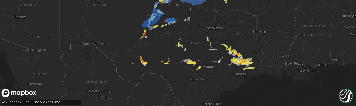
Hail Map in Texas on May 1, 2024
The weather event in Texas on May 1, 2024 includes Wind, Hail, and Tornado maps. 12 states and 454 cities were impacted and suffered possible damage. The total estimated number of properties impacted is 83,783.
Want more than just the map?
Turn this storm into a full workflow.
- Owner + property data so you know who to knock
- OnDemand branded weather history reports to win the "did we even have hail?" argument
- RoofTrace estimate so reps stop guessing numbers at the door
Bought this map? Upgrade within 7 days and we'll credit the $230. (10-15 min setup call)
Wind
Hail
Tornado
83,783
Estimated number of impacted properties by a 1.00" hail or larger6,766
Estimated number of impacted properties by a 1.75" hail or larger261
Estimated number of impacted properties by a 2.50" hail or largerStorm reports in Texas
Texas
| Date | Description |
|---|---|
| 05/01/20246:58 PM CDT | Minor hail dents on automobile exterior. |
| 05/01/20246:56 PM CDT | A local report indicates 1.75 inch wind near 4 WSW Lubbock Int. Airp |
| 05/01/20246:56 PM CDT | West texas mesonet. Also gusted to 58 mph at 655 pm. |
| 05/01/20246:55 PM CDT | This very brief tornado began at 6:55 pm and lasted around 15 to 20 seconds... Confirmed by video. |
| 05/01/20246:53 PM CDT | A local report indicates 1.25 inch wind near 5 S Glen Rose |
| 05/01/20246:49 PM CDT | Report from mping: quarter |
| 05/01/20246:46 PM CDT | Report from mping: quarter |
| 05/01/20246:46 PM CDT | A local report indicates 1.00 inch wind near 4 SSW Wolf Creek Park |
| 05/01/20246:45 PM CDT | Report of quarter sized hail about 4 miles west of centerville. |
| 05/01/20246:44 PM CDT | Report from mping: quarter |
| 05/01/20246:43 PM CDT | West texas mesonet. Additional gust to 61 mph measured at 644 pm. |
| 05/01/20246:43 PM CDT | West texas mesonet. |
| 05/01/20246:43 PM CDT | Report from mping: ping pong ball |
| 05/01/20246:41 PM CDT | West texas mesonet. Additional gusts ranging from 58 to 60 mph measured from 638 pm through 642 pm. |
| 05/01/20246:41 PM CDT | Em reports large tree down on lcr 444 with picture. Time estimated by radar. |
| 05/01/20246:38 PM CDT | Multiple trees and road blockages in shiloh area. Time estimated by radar. |
| 05/01/20246:38 PM CDT | Received images of a large tree downed onto a brick fence which also suffered damage from the collision. |
| 05/01/20246:35 PM CDT | Tree limbs several inches in diameter blown down in mackenzie park. Time estimated from radar. |
| 05/01/20246:34 PM CDT | A local report indicates 1.75 inch wind near 6 NNW Spearman |
| 05/01/20246:31 PM CDT | Corrects location of previous tstm wnd gst report from 5 nne tahoka. West texas mesonet. Additional gusts ranging from 58 to 64 mph were also measured from 630 to 636 p |
| 05/01/20246:31 PM CDT | A local report indicates 69 MPH wind near 5 NNE Tahoka |
| 05/01/20246:30 PM CDT | Slightly larger than quarter size hail fell at the lowes market along highway 207 in spearman. |
| 05/01/20246:30 PM CDT | Social media report. |
| 05/01/20246:21 PM CDT | Measured 3.1 inches with a micrometer. |
| 05/01/20246:17 PM CDT | A local report indicates 1.00 inch wind near Woodrow |
| 05/01/20246:16 PM CDT | Corrects time and location of previous hail report from woodrow. Fire dept reported mostly quarter size stones with a few slightly larger. |
| 05/01/20246:01 PM CDT | Large tree downed across powerlines. |
| 05/01/20245:59 PM CDT | Downed power line in groesbeck. Time estimated via radar. |
| 05/01/20245:57 PM CDT | Corrects time and location of previous hail report from 1 ne turkey. Social media photo shows partially melted hailstone measuring about 3.2 inches in diameter which wa |
| 05/01/20245:54 PM CDT | A local report indicates 59 MPH wind near 1 S Lamesa |
| 05/01/20245:54 PM CDT | A local report indicates 59 MPH wind near 2 SSE Lamesa |
| 05/01/20245:54 PM CDT | A local report indicates 61 MPH wind near 2 S Brownfield |
| 05/01/20245:54 PM CDT | . |
| 05/01/20245:54 PM CDT | West texas mesonet. Also gusted to 61 mph at 555 pm. |
| 05/01/20245:53 PM CDT | Report from mping: half dollar |
| 05/01/20245:49 PM CDT | Brief tornado touch down 7 miles nnw of turkey. |
| 05/01/20245:49 PM CDT | Brief tornado touchdown northwest of turkey. |
| 05/01/20245:42 PM CDT | A local report indicates 58 MPH wind near 1 SW Seagraves |
| 05/01/20245:42 PM CDT | A local report indicates 58 MPH wind near 1 WSW Seagraves |
| 05/01/20245:42 PM CDT | . |
| 05/01/20245:14 PM CDT | This brief tornado began around 5:14 pm and lifted around 5:16 pm... Confirmed by video. |
| 05/01/20245:14 PM CDT | A local report indicates 1.75 inch wind near Turkey |
| 05/01/20245:14 PM CDT | Re-issued to correct location of previous hail report from turkey. |
| 05/01/20244:46 PM CDT | . |
| 05/01/20244:46 PM CDT | A local report indicates 1.00 inch wind near 2 SSE Andrews |
| 05/01/20244:32 PM CDT | . |
| 05/01/20244:32 PM CDT | A local report indicates 1.50 inch wind near 9 SW Andrews |
| 05/01/20244:30 PM CDT | A local report indicates 1.75 inch wind near Clarendon |
| 05/01/20244:19 PM CDT | A local report indicates 4.00 inch wind near 4 WNW Clarendon |
| 05/01/20244:10 PM CDT | Tornado at this location began around 4:10 pm and lifted around 4:19 pm... Confirmed by video. |
| 05/01/20244:00 PM CDT | A local report indicates 1.75 inch wind near 8 WSW Greenbelt Lake |
| 05/01/20243:58 PM CDT | A very brief tornado occurred at this location and was confirmed by video. |
| 05/01/20243:48 PM CDT | A local report indicates 1.50 inch wind near 5 W Clarendon |
| 05/01/20243:21 PM CDT | . |
| 05/01/20243:21 PM CDT | A local report indicates 1.75 inch wind near 11 S Fort Stockton |
| 05/01/20242:41 PM CDT | . |
| 05/01/20242:41 PM CDT | A local report indicates 1.00 inch wind near 3 E Fort Stockton |
| 05/01/20242:35 PM CDT | [landspout] two landspouts reported. No damage reported. |
| 05/01/20241:52 PM CDT | [landspout] no damage reported. |
| 05/01/20242:06 AM CDT | A local report indicates 1.50 inch wind near 2 SSW Coldspring |
| 04/30/202411:20 PM CDT | A roof to a house was partially blown off. |
| 04/30/202411:12 PM CDT | There was part of a roof blown off and a few trees blown down at the high school and park in mason. |
| 04/30/202410:50 PM CDT | Downed power lines at lake coleman. |
| 04/30/202410:30 PM CDT | Trees down on ward st... Near highway 94. |
| 04/30/20249:37 PM CDT | Report from mping: quarter |
| 04/30/20249:33 PM CDT | West texas mesonet wind gust. |
| 04/30/20249:14 PM CDT | Clarendon mesonet wind gust. |
| 04/30/20248:54 PM CDT | A local report indicates 80 MPH wind near 1 SSE Jayton |
| 04/30/20248:54 PM CDT | West texas mesonet. Additional gusts ranging from 60 to 71 mph measured from 853 pm through 856 pm. |
| 04/30/20248:34 PM CDT | West texas mesonet. |
| 04/30/20248:34 PM CDT | A local report indicates 59 MPH wind near 7 WSW Lakeview |
| 04/30/20248:28 PM CDT | A local report indicates 58 MPH wind near 3 N Roaring Springs |
| 04/30/20248:28 PM CDT | West texas mesonet. |
| 04/30/20248:22 PM CDT | West texas mesonet. |
| 04/30/20248:10 PM CDT | Report from social media. |
| 04/30/20248:07 PM CDT | A local report indicates a tornado near 1 NE Turkey |
| 04/30/20248:05 PM CDT | West texas mesonet. |
| 04/30/20248:05 PM CDT | A local report indicates 59 MPH wind near 2 WSW Turkey |
| 04/30/20248:02 PM CDT | West texas mesonet. |
| 04/30/20248:02 PM CDT | A local report indicates 69 MPH wind near 3 NNW Mcadoo |
| 04/30/20248:01 PM CDT | Hall county sheriff dispatch confirms tornado ongoing northeast of turkey. |
| 04/30/20248:01 PM CDT | A local report indicates a tornado near 4 NE Turkey |
| 04/30/20247:52 PM CDT | Re-issued to correct time and location of previous tornado report from 1 ne turkey. Multiple social media photos and videos of a tornado several miles northeast of turk |
| 04/30/20247:51 PM CDT | A local report indicates 62 MPH wind near 2 NNE Floydada |
| 04/30/20247:51 PM CDT | West texas mesonet. Additional gust to 61 mph measured at 755 pm. |
| 04/30/20247:44 PM CDT | Report from mping: ping pong ball |
| 04/30/20247:29 PM CDT | West texas mesonet. Additional gusts ranging from 58 to 59 mph measured from 724 pm through 728 pm. |
| 04/30/20247:29 PM CDT | A local report indicates 61 MPH wind near 5 SSW Graham |
| 04/30/20247:24 PM CDT | Report from social media. |
| 04/30/20247:20 PM CDT | [landspout] media relayed video of a landspout occurring near petersburg. Location estimated. |
| 04/30/20247:12 PM CDT | Report from social media. |
| 04/30/20247:10 PM CDT | Lubbock int. Airport asos. Additional gusts ranging from 58 to 59 mph measured from 654 pm through 709 pm. |
| 04/30/20247:10 PM CDT | Media relayed video of brief touchdown of a weak rope tornado between lorenzo and petersburg. |
| 04/30/20247:07 PM CDT | West texas mesonet. |
| 04/30/20247:05 PM CDT | A local report indicates 73 MPH wind near 4 E Lubbock |
| 04/30/20247:04 PM CDT | West texas mesonet. Additional gusts ranging from 58 to 67 mph measured from 657 pm through 706 pm. |
| 04/30/20247:00 PM CDT | Estimated gusts to 80mph for approx 20 minutes. |
All States Impacted by Hail Map on May 1, 2024
Cities Impacted by Hail Map on May 1, 2024
- Hollister, OK
- Frederick, OK
- Loveland, OK
- Valley Center, KS
- Tuttle, OK
- Atoka, OK
- Wapanucka, OK
- Coleman, OK
- Caddo, OK
- Caney, OK
- Tupelo, OK
- Coalgate, OK
- Centrahoma, OK
- Medford, OK
- Deer Creek, OK
- Braman, OK
- Nardin, OK
- Fort Stockton, TX
- Alpine, TX
- Belle Glade, FL
- Clarendon, TX
- Waverly, GA
- Brunswick, GA
- Marathon, TX
- Pampa, TX
- Arcadia, FL
- Stinnett, TX
- Spearman, TX
- Mclean, TX
- Prairie Hill, TX
- Miami, TX
- Perryton, TX
- Andrews, TX
- Milburn, OK
- Stonewall, OK
- Lelia Lake, TX
- Hedley, TX
- Coolidge, TX
- Groesbeck, TX
- Seminole, TX
- Floydada, TX
- Lehigh Acres, FL
- Idalou, TX
- Claude, TX
- Lockney, TX
- Turkey, TX
- Mexia, TX
- Seagraves, TX
- Quitaque, TX
- Kermit, TX
- Immokalee, FL
- Lorenzo, TX
- Naples, FL
- Grinnell, KS
- Healy, KS
- Brownfield, TX
- Waverly, KY
- Ralls, TX
- Clifton, TX
- Meridian, TX
- Valley Mills, TX
- Corydon, KY
- Lamesa, TX
- Welch, TX
- Ackerly, TX
- Denver City, TX
- Wilson, TX
- Lubbock, TX
- Tahoka, TX
- Gove, KS
- Evansville, IN
- Henderson, KY
- Silverton, TX
- Blanco, TX
- Reed, KY
- Spottsville, KY
- Walnut Springs, TX
- Iredell, TX
- Kendalia, TX
- Boerne, TX
- Newburgh, IN
- Normangee, TX
- Meadow, TX
- Morgan, TX
- Akron, CO
- Scott City, KS
- Jewett, TX
- Centerville, TX
- Oakley, KS
- Gruver, TX
- Teague, TX
- Wolfforth, TX
- Ropesville, TX
- Marquez, TX
- Glen Rose, TX
- Shallowater, TX
- Yuma, CO
- Johnson City, TX
- Buffalo, TX
- Leona, TX
- Richland, IN
- Rockport, IN
- Quinter, KS
- Slaton, TX
- Jasper, TX
- Donie, TX
- Park, KS
- Anton, CO
- Gail, TX
- Dripping Springs, TX
- Joes, CO
- Eckley, CO
- Williamsville, MO
- Greenville, MO
- Lakeview, TX
- Loop, TX
- Odonnell, TX
- Abernathy, TX
- Crosbyton, TX
- New Deal, TX
- Post, TX
- Ransom Canyon, TX
- Spur, TX
- Justiceburg, TX
- Canadian, TX
- Oakwood, TX
- Midway, TX
- Petersburg, TX
- Austin, TX
- Buda, TX
- Vernon, CO
- Wray, CO
- Kirk, CO
- Plainview, TX
- Hale Center, TX
- Collyer, KS
- Crockett, TX
- Thornton, TX
- Kress, TX
- Higgins, TX
- Haigler, NE
- Saint Francis, KS
- Cope, CO
- Seibert, CO
- Snyder, TX
- Flagler, CO
- Prairie Du Rocher, IL
- Bloomsdale, MO
- Vona, CO
- Childress, TX
- Valmeyer, IL
- Dighton, KS
- Waterloo, IL
- Wakeeney, KS
- Parks, NE
- Lovelady, TX
- Evansville, IL
- Red Bud, IL
- Tulia, TX
- Fults, IL
- Stratton, CO
- Fluvanna, TX
- Matador, TX
- Booker, TX
- Benkelman, NE
- Ozona, TX
- Idalia, CO
- Burlington, CO
- Trinity, TX
- Jayton, TX
- Max, NE
- Palisade, NE
- Stratton, NE
- Sonora, TX
- Paint Rock, TX
- Bird City, KS
- Aspermont, TX
- Utica, KS
- Taylor, TX
- Girard, TX
- Old Glory, TX
- Memphis, TX
- McDonald, KS
- Kanorado, KS
- Goodland, KS
- Trenton, NE
- Ballinger, TX
- Rowena, TX
- Paducah, TX
- Eldorado, TX
- Thrall, TX
- Culbertson, NE
- Voss, TX
- Eden, TX
- Thorndale, TX
- Fredericksburg, TX
- Haskell, TX
- Quanah, TX
- Throckmorton, TX
- Rexford, KS
- Ransom, KS
- Willow City, TX
- McCook, NE
- Madisonville, TX
- Rule, TX
- London, TX
- Winters, TX
- Llano, TX
- Selden, KS
- Hoxie, KS
- Ogallah, KS
- Crowell, TX
- Hawley, TX
- Junction, TX
- Rotan, TX
- Millersview, TX
- Groom, TX
- Wellington, TX
- Quail, TX
- Shamrock, TX
- Edson, KS
- Colby, KS
- Atwood, KS
- Rockdale, TX
- Groveton, TX
- Seymour, TX
- Lexington, TX
- Doole, TX
- Ellis, KS
- Huntsville, TX
- Tribune, KS
- Melvin, TX
- Lohn, TX
- Milano, TX
- Caldwell, TX
- Mason, TX
- Bedias, TX
- Coupland, TX
- Sharon Springs, KS
- Pointblank, TX
- Morland, KS
- Hill City, KS
- Penokee, KS
- Jennings, KS
- Lenora, KS
- Clayton, KS
- Richards, TX
- Altus, OK
- Anson, TX
- Oakhurst, TX
- Rockwood, TX
- Dresden, KS
- Norton, KS
- Grainfield, KS
- Eldorado, OK
- Mangum, OK
- Gould, OK
- Duke, OK
- Blair, OK
- Olustee, OK
- Altus Afb, OK
- Mountain Park, OK
- Headrick, OK
- Elmer, OK
- Snyder, OK
- Tipton, OK
- Davidson, OK
- Odell, TX
- Vernon, TX
- Chillicothe, TX
- Livingston, TX
- Onalaska, TX
- Leoti, KS
- Miles, TX
- Electra, TX
- Bogue, KS
- Stockton, KS
- Phillipsburg, KS
- Harper, TX
- Doss, TX
- Palco, KS
- Damar, KS
- Newcastle, TX
- Coldspring, TX
- Hearne, TX
- Kensington, KS
- Winona, KS
- Anderson, TX
- New Waverly, TX
- Almena, KS
- Stamford, NE
- Orleans, NE
- Beaver City, NE
- Alma, NE
- Prairie View, KS
- Long Island, KS
- Logan, KS
- Republican City, NE
- Bloomington, NE
- Agra, KS
- Naponee, NE
- Riverton, NE
- Franklin, NE
- Glade, KS
- Smith Center, KS
- Kirwin, KS
- Hays, KS
- Woodston, KS
- Gaylord, KS
- Athol, KS
- Natoma, KS
- Plainville, KS
- Cedar, KS
- Portis, KS
- Lebanon, KS
- Osborne, KS
- Esbon, KS
- Catharine, KS
- Alton, KS
- Victoria, KS
- Montgomery, TX
- Lawton, OK
- Chattanooga, OK
- Faxon, OK
- Indiahoma, OK
- Cache, OK
- Walters, OK
- Geronimo, OK
- Grandfield, OK
- Elgin, OK
- Fletcher, OK
- Rush Springs, OK
- Marlow, OK
- Duncan, OK
- Devol, OK
- Comanche, OK
- Randlett, OK
- Temple, OK
- Ninnekah, OK
- Chickasha, OK
- Blanchard, OK
- Alex, OK
- Bradley, OK
- Burnet, TX
- Marble Falls, TX
- Beeler, KS
- Kingsland, TX
- Gorham, KS
- Burr Oak, KS
- Downs, KS
- Paradise, KS
- Mankato, KS
- Luray, KS
- Formoso, KS
- Tipton, KS
- Waldo, KS
- Beloit, KS
- Cawker City, KS
- Randall, KS
- Jewell, KS
- Glen Elder, KS
- Sylvan Grove, KS
- Russell, KS
- Lucas, KS
- Hunter, KS
- Walker, KS
- Bunker Hill, KS
- Willis, TX
- Belleville, KS
- Webber, KS
- Scandia, KS
- Republic, KS
- Courtland, KS
- Hardy, NE
- Byron, NE
- Deshler, NE
- Chester, NE
- Cleveland, TX
- Conroe, TX
- Shepherd, TX
- Goodrich, TX
- Talpa, TX
- Warren, TX
- Shenandoah, IA
- Saratoga, TX
- Woodville, TX
- Kountze, TX
- Essex, IA
- Clarinda, IA
- Dayton, TX
- Sainte Genevieve, MO
- Huffman, TX
- Crosby, TX
- Gatesville, TX
- Moody, TX
- Liberty, TX
- Gravity, IA
- New Market, IA
- McGregor, TX
- Lenox, IA
- Bedford, IA
- Oglesby, TX
- Sharpsburg, IA
- Hull, TX
- Troy, TX
- Eddy, TX
- Lorena, TX
- Bruceville, TX
- Devers, TX
- Sour Lake, TX
- Batson, TX
- Oak, NE
- Davenport, NE
- Edgar, NE
- Ong, NE
- Shickley, NE
- Geneva, NE
- Belvidere, NE
- Strang, NE
- Bruning, NE
- Carleton, NE
- Ohiowa, NE
- Milford, NE
- Crete, NE
- Milligan, NE
- Lincoln, NE
- Dorchester, NE
- Western, NE
- Pleasant Dale, NE
- Friend, NE
- Tobias, NE
- Exeter, NE
- Denton, NE
- Daykin, NE
- De Witt, NE
- Cortland, NE
- Wilber, NE
- Martell, NE
- Hallam, NE
- Alexandria, NE
- Swanton, NE
- Clatonia, NE
- Beaumont, TX
- Navasota, TX
- Washington, TX
- Chilton, TX
- Sprague, NE
- Firth, NE
- Hickman, NE
- Roca, NE
- Bennet, NE
- Crawford, TX
- Waller, TX
- Hempstead, TX


