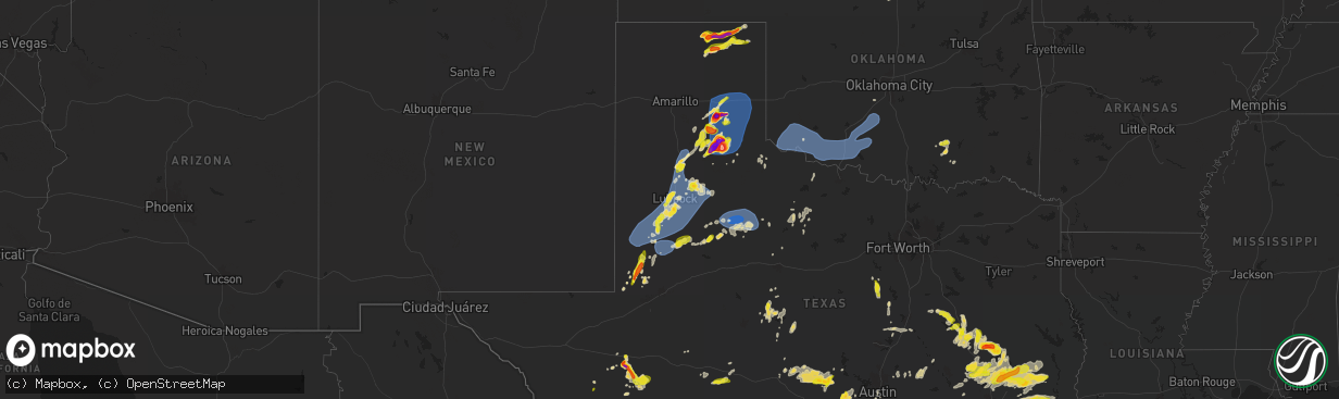
Hail Map on May 1, 2024
The weather event on May 1, 2024 includes Wind, Hail, and Tornado maps. 12 states and 454 cities were impacted and suffered possible damage. The total estimated number of properties impacted is 91,040.
Want more than just the map?
Turn this storm into a full workflow.
- Owner + property data so you know who to knock
- OnDemand branded weather history reports to win the "did we even have hail?" argument
- RoofTrace estimate so reps stop guessing numbers at the door
Bought this map? Upgrade within 7 days and we'll credit the $230. (10-15 min setup call)
Wind
Hail
Tornado
91,040
Estimated number of impacted properties by a 1.00" hail or larger8,128
Estimated number of impacted properties by a 1.75" hail or larger788
Estimated number of impacted properties by a 2.50" hail or largerStates Impacted by Hail Map on May 1, 2024
Storm reports
Nebraska
| Date | Description |
|---|---|
| 05/01/20243:00 AM CDT | A local report indicates 60 MPH wind near 2 N Firth |
| 05/01/20242:47 AM CDT | A local report indicates 58 MPH wind near 1 ENE Hickman |
| 05/01/20242:13 AM CDT | Also a measured 55 mph gust at a separate but nearly collocated station. |
| 05/01/20241:27 AM CDT | Upr station. |
| 05/01/20241:22 AM CDT | Upr station. |
| 05/01/20241:01 AM CDT | 1.11 inches of rain. |
| 05/01/20241:01 AM CDT | 0.90 inches of rainfall. |
| 05/01/202412:33 AM CDT | Facebook report of trees down in a yard. Time estimated from radar. |
| 05/01/202412:33 AM CDT | Dispatch reports that multiple trees and some power lines were downed in and near town... Including some that had to be removed from highway 136. A sizable portion of t |
| 04/30/202411:35 PM CDT | A local report indicates 59 MPH wind near 6 W Huntley |
| 04/30/20249:20 PM CDT | Social media report of nickel to quarter size hail. |
| 04/30/20249:15 PM CDT | Corrects previous hail report from 3 w trenton. Ground covered with quarter sized hail. |
| 04/30/20249:15 PM CDT | Facebook picture of hailstone one inch in diameter. |
| 04/30/20249:05 PM CDT | Ground covered with quarter sized hail. |
| 04/30/20248:40 PM CDT | Delayed report. Ping pong to golf ball sized hail measured at hwy 34 and rd 312. |
| 04/30/20248:37 PM CDT | Delayed report. |
| 04/30/20248:05 PM CDT | Storm chaser had a hailstone measuring 2.3 inches using a caliper. |
| 04/30/20248:03 PM CDT | Corrects previous hail report from haigler. Delayed report. Half dollar to ping pong ball sized hail reported. Hail fell for a duration of 10 minutes. |
| 04/30/20248:03 PM CDT | Delayed report. Half dollar to ping pong ball sized hail reported. Hail fell for a duration of 10 minutes. |
Missouri
| Date | Description |
|---|---|
| 05/01/20246:30 PM CDT | 10-12 diameter tree down on king school road. |
Colorado
| Date | Description |
|---|---|
| 05/01/20246:55 PM CDT | Location via report and radar. |
| 04/30/20248:15 PM CDT | Public report and photo via social media of quarter size hail. |
| 04/30/20247:52 PM CDT | Social media report with pictures of pea to quarter sized hail. |
| 04/30/20247:49 PM CDT | Social media report with picture of one inch hail in wray. |
| 04/30/20247:42 PM CDT | 7 minute duration of pea to quarter sized hail. |
Texas
| Date | Description |
|---|---|
| 05/01/20246:58 PM CDT | Minor hail dents on automobile exterior. |
| 05/01/20246:56 PM CDT | West texas mesonet. Also gusted to 58 mph at 655 pm. |
| 05/01/20246:56 PM CDT | A local report indicates 1.75 inch wind near 4 WSW Lubbock Int. Airp |
| 05/01/20246:55 PM CDT | This very brief tornado began at 6:55 pm and lasted around 15 to 20 seconds... Confirmed by video. |
| 05/01/20246:53 PM CDT | A local report indicates 1.25 inch wind near 5 S Glen Rose |
| 05/01/20246:49 PM CDT | Report from mping: quarter |
| 05/01/20246:46 PM CDT | Report from mping: quarter |
| 05/01/20246:46 PM CDT | A local report indicates 1.00 inch wind near 4 SSW Wolf Creek Park |
| 05/01/20246:45 PM CDT | Report of quarter sized hail about 4 miles west of centerville. |
| 05/01/20246:44 PM CDT | Report from mping: quarter |
| 05/01/20246:43 PM CDT | West texas mesonet. |
| 05/01/20246:43 PM CDT | Report from mping: ping pong ball |
| 05/01/20246:43 PM CDT | West texas mesonet. Additional gust to 61 mph measured at 644 pm. |
| 05/01/20246:41 PM CDT | Em reports large tree down on lcr 444 with picture. Time estimated by radar. |
| 05/01/20246:41 PM CDT | West texas mesonet. Additional gusts ranging from 58 to 60 mph measured from 638 pm through 642 pm. |
| 05/01/20246:38 PM CDT | Multiple trees and road blockages in shiloh area. Time estimated by radar. |
| 05/01/20246:38 PM CDT | Received images of a large tree downed onto a brick fence which also suffered damage from the collision. |
| 05/01/20246:35 PM CDT | Tree limbs several inches in diameter blown down in mackenzie park. Time estimated from radar. |
| 05/01/20246:34 PM CDT | A local report indicates 1.75 inch wind near 6 NNW Spearman |
| 05/01/20246:31 PM CDT | Corrects location of previous tstm wnd gst report from 5 nne tahoka. West texas mesonet. Additional gusts ranging from 58 to 64 mph were also measured from 630 to 636 p |
| 05/01/20246:31 PM CDT | A local report indicates 69 MPH wind near 5 NNE Tahoka |
| 05/01/20246:30 PM CDT | Social media report. |
| 05/01/20246:30 PM CDT | Slightly larger than quarter size hail fell at the lowes market along highway 207 in spearman. |
| 05/01/20246:21 PM CDT | Measured 3.1 inches with a micrometer. |
| 05/01/20246:17 PM CDT | A local report indicates 1.00 inch wind near Woodrow |
| 05/01/20246:16 PM CDT | Corrects time and location of previous hail report from woodrow. Fire dept reported mostly quarter size stones with a few slightly larger. |
| 05/01/20246:01 PM CDT | Large tree downed across powerlines. |
| 05/01/20245:59 PM CDT | Downed power line in groesbeck. Time estimated via radar. |
| 05/01/20245:57 PM CDT | Corrects time and location of previous hail report from 1 ne turkey. Social media photo shows partially melted hailstone measuring about 3.2 inches in diameter which wa |
| 05/01/20245:54 PM CDT | West texas mesonet. Also gusted to 61 mph at 555 pm. |
| 05/01/20245:54 PM CDT | A local report indicates 59 MPH wind near 1 S Lamesa |
| 05/01/20245:54 PM CDT | A local report indicates 59 MPH wind near 2 SSE Lamesa |
| 05/01/20245:54 PM CDT | . |
| 05/01/20245:54 PM CDT | A local report indicates 61 MPH wind near 2 S Brownfield |
| 05/01/20245:53 PM CDT | Report from mping: half dollar |
| 05/01/20245:49 PM CDT | Brief tornado touch down 7 miles nnw of turkey. |
| 05/01/20245:49 PM CDT | Brief tornado touchdown northwest of turkey. |
| 05/01/20245:42 PM CDT | A local report indicates 58 MPH wind near 1 WSW Seagraves |
| 05/01/20245:42 PM CDT | A local report indicates 58 MPH wind near 1 SW Seagraves |
| 05/01/20245:42 PM CDT | . |
| 05/01/20245:14 PM CDT | Re-issued to correct location of previous hail report from turkey. |
| 05/01/20245:14 PM CDT | This brief tornado began around 5:14 pm and lifted around 5:16 pm... Confirmed by video. |
| 05/01/20245:14 PM CDT | A local report indicates 1.75 inch wind near Turkey |
| 05/01/20244:46 PM CDT | . |
| 05/01/20244:46 PM CDT | A local report indicates 1.00 inch wind near 2 SSE Andrews |
| 05/01/20244:32 PM CDT | A local report indicates 1.50 inch wind near 9 SW Andrews |
| 05/01/20244:32 PM CDT | . |
| 05/01/20244:30 PM CDT | A local report indicates 1.75 inch wind near Clarendon |
| 05/01/20244:19 PM CDT | A local report indicates 4.00 inch wind near 4 WNW Clarendon |
| 05/01/20244:10 PM CDT | Tornado at this location began around 4:10 pm and lifted around 4:19 pm... Confirmed by video. |
| 05/01/20244:00 PM CDT | A local report indicates 1.75 inch wind near 8 WSW Greenbelt Lake |
| 05/01/20243:58 PM CDT | A very brief tornado occurred at this location and was confirmed by video. |
| 05/01/20243:48 PM CDT | A local report indicates 1.50 inch wind near 5 W Clarendon |
| 05/01/20243:21 PM CDT | A local report indicates 1.75 inch wind near 11 S Fort Stockton |
| 05/01/20243:21 PM CDT | . |
| 05/01/20242:41 PM CDT | A local report indicates 1.00 inch wind near 3 E Fort Stockton |
| 05/01/20242:41 PM CDT | . |
| 05/01/20242:35 PM CDT | [landspout] two landspouts reported. No damage reported. |
| 05/01/20241:52 PM CDT | [landspout] no damage reported. |
| 05/01/20242:06 AM CDT | A local report indicates 1.50 inch wind near 2 SSW Coldspring |
| 04/30/202411:20 PM CDT | A roof to a house was partially blown off. |
| 04/30/202411:12 PM CDT | There was part of a roof blown off and a few trees blown down at the high school and park in mason. |
| 04/30/202410:50 PM CDT | Downed power lines at lake coleman. |
| 04/30/202410:30 PM CDT | Trees down on ward st... Near highway 94. |
| 04/30/20249:37 PM CDT | Report from mping: quarter |
| 04/30/20249:33 PM CDT | West texas mesonet wind gust. |
| 04/30/20249:14 PM CDT | Clarendon mesonet wind gust. |
| 04/30/20248:54 PM CDT | West texas mesonet. Additional gusts ranging from 60 to 71 mph measured from 853 pm through 856 pm. |
| 04/30/20248:54 PM CDT | A local report indicates 80 MPH wind near 1 SSE Jayton |
| 04/30/20248:34 PM CDT | A local report indicates 59 MPH wind near 7 WSW Lakeview |
| 04/30/20248:34 PM CDT | West texas mesonet. |
| 04/30/20248:28 PM CDT | A local report indicates 58 MPH wind near 3 N Roaring Springs |
| 04/30/20248:28 PM CDT | West texas mesonet. |
| 04/30/20248:22 PM CDT | West texas mesonet. |
| 04/30/20248:10 PM CDT | Report from social media. |
| 04/30/20248:07 PM CDT | A local report indicates a tornado near 1 NE Turkey |
| 04/30/20248:05 PM CDT | A local report indicates 59 MPH wind near 2 WSW Turkey |
| 04/30/20248:05 PM CDT | West texas mesonet. |
| 04/30/20248:02 PM CDT | West texas mesonet. |
| 04/30/20248:02 PM CDT | A local report indicates 69 MPH wind near 3 NNW Mcadoo |
| 04/30/20248:01 PM CDT | Hall county sheriff dispatch confirms tornado ongoing northeast of turkey. |
| 04/30/20248:01 PM CDT | A local report indicates a tornado near 4 NE Turkey |
| 04/30/20247:52 PM CDT | Re-issued to correct time and location of previous tornado report from 1 ne turkey. Multiple social media photos and videos of a tornado several miles northeast of turk |
| 04/30/20247:51 PM CDT | A local report indicates 62 MPH wind near 2 NNE Floydada |
| 04/30/20247:51 PM CDT | West texas mesonet. Additional gust to 61 mph measured at 755 pm. |
| 04/30/20247:44 PM CDT | Report from mping: ping pong ball |
| 04/30/20247:29 PM CDT | A local report indicates 61 MPH wind near 5 SSW Graham |
| 04/30/20247:29 PM CDT | West texas mesonet. Additional gusts ranging from 58 to 59 mph measured from 724 pm through 728 pm. |
| 04/30/20247:24 PM CDT | Report from social media. |
| 04/30/20247:20 PM CDT | [landspout] media relayed video of a landspout occurring near petersburg. Location estimated. |
| 04/30/20247:12 PM CDT | Report from social media. |
| 04/30/20247:10 PM CDT | Lubbock int. Airport asos. Additional gusts ranging from 58 to 59 mph measured from 654 pm through 709 pm. |
| 04/30/20247:10 PM CDT | Media relayed video of brief touchdown of a weak rope tornado between lorenzo and petersburg. |
| 04/30/20247:07 PM CDT | West texas mesonet. |
| 04/30/20247:05 PM CDT | A local report indicates 73 MPH wind near 4 E Lubbock |
| 04/30/20247:04 PM CDT | West texas mesonet. Additional gusts ranging from 58 to 67 mph measured from 657 pm through 706 pm. |
| 04/30/20247:00 PM CDT | Estimated gusts to 80mph for approx 20 minutes. |
Kansas
| Date | Description |
|---|---|
| 05/01/20246:50 PM CDT | Live video feed from storm chaser showed them holding hailstones of approximately golf ball size. Location and hail size approximate. |
| 05/01/20246:45 PM CDT | Facebook picture of several hailstones matching the size of a quarter. |
| 05/01/20246:26 PM CDT | [landspout] brief landspout with ground circulation about 100 yds east of hwy 23. Video sent in. |
| 05/01/20241:34 AM CDT | Personal weather station. |
| 05/01/20241:02 AM CDT | Ks mesonet. |
| 05/01/202412:50 AM CDT | Trained spotter measured on home weather station and called in the report. |
| 05/01/202412:30 AM CDT | Delayed report of a shed with damage 5 miles southeast of hill city. Timing based on radar and nearby asos. |
| 05/01/202412:30 AM CDT | Delayed report of exceptional damage to a large shed. One wall blown in... Roof blown away and substructure partially collapsed... Metal siding blown/peeled away. |
| 05/01/202412:30 AM CDT | Dispatch reports some tree damage in town. Time estimated from radar. |
| 05/01/202412:24 AM CDT | New outbuilding destroyed. Also reports of trees down around the area. |
| 05/01/202412:20 AM CDT | Dispatch reported a tree down on k9 highway. Time estimated from radar. |
| 05/01/202412:15 AM CDT | A local report indicates 79 MPH wind near Smith Center Airport |
| 05/01/202412:15 AM CDT | Dispatch reports a tree and some branches down in town... Along with damage to a store sign. |
| 05/01/202412:09 AM CDT | A local report indicates 68 MPH wind near Smith Center Airport |
| 04/30/202411:49 PM CDT | A local report indicates 61 MPH wind near 3 WSW Agra |
| 04/30/202411:49 PM CDT | Ksu mesonet. |
| 04/30/202411:44 PM CDT | Raws station. |
| 04/30/202411:40 PM CDT | A local report indicates 60 MPH wind near 5 WSW Agra |
| 04/30/202411:35 PM CDT | A local report indicates 63 MPH wind near Phillipsburg Airport |
| 04/30/202411:30 PM CDT | Corrects time of previous tstm wnd dmg report from phillipsburg. Dispatch reports some tree damage in town. Time estimated from radar. |
| 04/30/202411:30 PM CDT | Corrects previous tstm wnd dmg report from 5 se hill city. Delayed report of a shed with damage 5 miles southeast of hill city. Timing based on radar and nearby asos. |
| 04/30/202411:30 PM CDT | Corrects previous tstm wnd dmg report from 7 sse bogue. Delayed report of exceptional damage to a large shed. One wall blown in... Roof blown away and substructure part |
| 04/30/202411:29 PM CDT | Ksu mesonet. |
| 04/30/202411:25 PM CDT | Corrects time of previous tstm wnd dmg report from 3 e logan. Dispatch reported a tree down on k9 highway. Time estimated from radar. |
| 04/30/202411:04 PM CDT | Weatherunderground site kkslenor20. |
| 04/30/202411:01 PM CDT | Weatherunderground site kkslenor7. |
| 04/30/202410:55 PM CDT | Kansas mesonet. Wind gust measured at 10 meter height above ground. |
| 04/30/202410:44 PM CDT | Weatherunderground site kkspark1. |
| 04/30/202410:39 PM CDT | Weatherunderground site kkshoxie18. |
| 04/30/202410:38 PM CDT | Weatherunderground site kkshoxie18. |
| 04/30/202410:35 PM CDT | Weatherunderground site kkshoxie18. |
| 04/30/202410:15 PM CDT | Delayed reported of tennis ball sized hail that caused damage at a house. |
| 04/30/202410:15 PM CDT | Weatherunderground site kkshoxie16. |
| 04/30/202410:00 PM CDT | Hail the size of quarters fell for a duration of 5 minutes. |
| 04/30/20249:35 PM CDT | A local report indicates 1.00 inch wind near WaKeeney |
| 04/30/20249:15 PM CDT | Corrects previous hail report from 25 se gove. Delayed reported of tennis ball sized hail that caused damage at a house. |
| 04/30/20249:12 PM CDT | [landspout] pictures of a landspout. |
| 04/30/20248:55 PM CDT | [landspout] video and pictures of a landspout/possible tornado. |
| 04/30/20248:52 PM CDT | [landspout] corrects previous landspout report from 21 sse gove. Multiple media outlets reported a possible landspout near the gove/lane county line. Location estimate |
| 04/30/20248:40 PM CDT | A local report indicates 1.75 inch wind near 4 SW WaKeeney |
| 04/30/20248:15 PM CDT | A local report indicates 4.00 inch wind near 15 S Gove |
| 04/30/20248:14 PM CDT | Live feed from storm chaser showing softball size hail. Hail size and location estimated. |
| 04/30/20248:14 PM CDT | Live f |
| 04/30/20248:10 PM CDT | Broadcast media provided pictures of hailstones 3.75 to 4.50 inches in diameter. |
| 04/30/20247:40 PM CDT | Delayed report. Baseball sized hail reported at rd g and hwy 23. Time radar estimated. Report via scott and lane counites ems. |
Oklahoma
| Date | Description |
|---|---|
| 05/01/20249:15 AM CDT | Delayed report. Relayed images. Radar estimated time. |
| 05/01/20241:00 AM CDT | Acme mesonet. |
| 04/30/202411:48 PM CDT | A local report indicates 60 MPH wind near 1 S Hollister |
| 04/30/202411:08 PM CDT | Klts. |
| 04/30/202411:05 PM CDT | Altus mesonet. |
Cities Impacted by Hail Map on May 1, 2024
- Hollister, OK
- Frederick, OK
- Loveland, OK
- Valley Center, KS
- Tuttle, OK
- Atoka, OK
- Wapanucka, OK
- Coleman, OK
- Caddo, OK
- Caney, OK
- Tupelo, OK
- Coalgate, OK
- Centrahoma, OK
- Medford, OK
- Deer Creek, OK
- Braman, OK
- Nardin, OK
- Fort Stockton, TX
- Alpine, TX
- Belle Glade, FL
- Clarendon, TX
- Waverly, GA
- Brunswick, GA
- Marathon, TX
- Pampa, TX
- Arcadia, FL
- Stinnett, TX
- Spearman, TX
- Mclean, TX
- Prairie Hill, TX
- Miami, TX
- Perryton, TX
- Andrews, TX
- Milburn, OK
- Stonewall, OK
- Lelia Lake, TX
- Hedley, TX
- Coolidge, TX
- Groesbeck, TX
- Seminole, TX
- Floydada, TX
- Lehigh Acres, FL
- Idalou, TX
- Claude, TX
- Lockney, TX
- Turkey, TX
- Mexia, TX
- Seagraves, TX
- Quitaque, TX
- Kermit, TX
- Immokalee, FL
- Lorenzo, TX
- Naples, FL
- Grinnell, KS
- Healy, KS
- Brownfield, TX
- Waverly, KY
- Ralls, TX
- Clifton, TX
- Meridian, TX
- Valley Mills, TX
- Corydon, KY
- Lamesa, TX
- Welch, TX
- Ackerly, TX
- Denver City, TX
- Wilson, TX
- Lubbock, TX
- Tahoka, TX
- Gove, KS
- Evansville, IN
- Henderson, KY
- Silverton, TX
- Blanco, TX
- Reed, KY
- Spottsville, KY
- Walnut Springs, TX
- Iredell, TX
- Kendalia, TX
- Boerne, TX
- Newburgh, IN
- Normangee, TX
- Meadow, TX
- Morgan, TX
- Akron, CO
- Scott City, KS
- Jewett, TX
- Centerville, TX
- Oakley, KS
- Gruver, TX
- Teague, TX
- Wolfforth, TX
- Ropesville, TX
- Marquez, TX
- Glen Rose, TX
- Shallowater, TX
- Yuma, CO
- Johnson City, TX
- Buffalo, TX
- Leona, TX
- Richland, IN
- Rockport, IN
- Quinter, KS
- Slaton, TX
- Jasper, TX
- Donie, TX
- Park, KS
- Anton, CO
- Gail, TX
- Dripping Springs, TX
- Joes, CO
- Eckley, CO
- Williamsville, MO
- Greenville, MO
- Lakeview, TX
- Loop, TX
- Odonnell, TX
- Abernathy, TX
- Crosbyton, TX
- New Deal, TX
- Post, TX
- Ransom Canyon, TX
- Spur, TX
- Justiceburg, TX
- Canadian, TX
- Oakwood, TX
- Midway, TX
- Petersburg, TX
- Austin, TX
- Buda, TX
- Vernon, CO
- Wray, CO
- Kirk, CO
- Plainview, TX
- Hale Center, TX
- Collyer, KS
- Crockett, TX
- Thornton, TX
- Kress, TX
- Higgins, TX
- Haigler, NE
- Saint Francis, KS
- Cope, CO
- Seibert, CO
- Snyder, TX
- Flagler, CO
- Prairie Du Rocher, IL
- Bloomsdale, MO
- Vona, CO
- Childress, TX
- Valmeyer, IL
- Dighton, KS
- Waterloo, IL
- Wakeeney, KS
- Parks, NE
- Lovelady, TX
- Evansville, IL
- Red Bud, IL
- Tulia, TX
- Fults, IL
- Stratton, CO
- Fluvanna, TX
- Matador, TX
- Booker, TX
- Benkelman, NE
- Ozona, TX
- Idalia, CO
- Burlington, CO
- Trinity, TX
- Jayton, TX
- Max, NE
- Palisade, NE
- Stratton, NE
- Sonora, TX
- Paint Rock, TX
- Bird City, KS
- Aspermont, TX
- Utica, KS
- Taylor, TX
- Girard, TX
- Old Glory, TX
- Memphis, TX
- McDonald, KS
- Kanorado, KS
- Goodland, KS
- Trenton, NE
- Ballinger, TX
- Rowena, TX
- Paducah, TX
- Eldorado, TX
- Thrall, TX
- Culbertson, NE
- Voss, TX
- Eden, TX
- Thorndale, TX
- Fredericksburg, TX
- Haskell, TX
- Quanah, TX
- Throckmorton, TX
- Rexford, KS
- Ransom, KS
- Willow City, TX
- McCook, NE
- Madisonville, TX
- Rule, TX
- London, TX
- Winters, TX
- Llano, TX
- Selden, KS
- Hoxie, KS
- Ogallah, KS
- Crowell, TX
- Hawley, TX
- Junction, TX
- Rotan, TX
- Millersview, TX
- Groom, TX
- Wellington, TX
- Quail, TX
- Shamrock, TX
- Edson, KS
- Colby, KS
- Atwood, KS
- Rockdale, TX
- Groveton, TX
- Seymour, TX
- Lexington, TX
- Doole, TX
- Ellis, KS
- Huntsville, TX
- Tribune, KS
- Melvin, TX
- Lohn, TX
- Milano, TX
- Caldwell, TX
- Mason, TX
- Bedias, TX
- Coupland, TX
- Sharon Springs, KS
- Pointblank, TX
- Morland, KS
- Hill City, KS
- Penokee, KS
- Jennings, KS
- Lenora, KS
- Clayton, KS
- Richards, TX
- Altus, OK
- Anson, TX
- Oakhurst, TX
- Rockwood, TX
- Dresden, KS
- Norton, KS
- Grainfield, KS
- Eldorado, OK
- Mangum, OK
- Gould, OK
- Duke, OK
- Blair, OK
- Olustee, OK
- Altus Afb, OK
- Mountain Park, OK
- Headrick, OK
- Elmer, OK
- Snyder, OK
- Tipton, OK
- Davidson, OK
- Odell, TX
- Vernon, TX
- Chillicothe, TX
- Livingston, TX
- Onalaska, TX
- Leoti, KS
- Miles, TX
- Electra, TX
- Bogue, KS
- Stockton, KS
- Phillipsburg, KS
- Harper, TX
- Doss, TX
- Palco, KS
- Damar, KS
- Newcastle, TX
- Coldspring, TX
- Hearne, TX
- Kensington, KS
- Winona, KS
- Anderson, TX
- New Waverly, TX
- Almena, KS
- Stamford, NE
- Orleans, NE
- Beaver City, NE
- Alma, NE
- Prairie View, KS
- Long Island, KS
- Logan, KS
- Republican City, NE
- Bloomington, NE
- Agra, KS
- Naponee, NE
- Riverton, NE
- Franklin, NE
- Glade, KS
- Smith Center, KS
- Kirwin, KS
- Hays, KS
- Woodston, KS
- Gaylord, KS
- Athol, KS
- Natoma, KS
- Plainville, KS
- Cedar, KS
- Portis, KS
- Lebanon, KS
- Osborne, KS
- Esbon, KS
- Catharine, KS
- Alton, KS
- Victoria, KS
- Montgomery, TX
- Lawton, OK
- Chattanooga, OK
- Faxon, OK
- Indiahoma, OK
- Cache, OK
- Walters, OK
- Geronimo, OK
- Grandfield, OK
- Elgin, OK
- Fletcher, OK
- Rush Springs, OK
- Marlow, OK
- Duncan, OK
- Devol, OK
- Comanche, OK
- Randlett, OK
- Temple, OK
- Ninnekah, OK
- Chickasha, OK
- Blanchard, OK
- Alex, OK
- Bradley, OK
- Burnet, TX
- Marble Falls, TX
- Beeler, KS
- Kingsland, TX
- Gorham, KS
- Burr Oak, KS
- Downs, KS
- Paradise, KS
- Mankato, KS
- Luray, KS
- Formoso, KS
- Tipton, KS
- Waldo, KS
- Beloit, KS
- Cawker City, KS
- Randall, KS
- Jewell, KS
- Glen Elder, KS
- Sylvan Grove, KS
- Russell, KS
- Lucas, KS
- Hunter, KS
- Walker, KS
- Bunker Hill, KS
- Willis, TX
- Belleville, KS
- Webber, KS
- Scandia, KS
- Republic, KS
- Courtland, KS
- Hardy, NE
- Byron, NE
- Deshler, NE
- Chester, NE
- Cleveland, TX
- Conroe, TX
- Shepherd, TX
- Goodrich, TX
- Talpa, TX
- Warren, TX
- Shenandoah, IA
- Saratoga, TX
- Woodville, TX
- Kountze, TX
- Essex, IA
- Clarinda, IA
- Dayton, TX
- Sainte Genevieve, MO
- Huffman, TX
- Crosby, TX
- Gatesville, TX
- Moody, TX
- Liberty, TX
- Gravity, IA
- New Market, IA
- McGregor, TX
- Lenox, IA
- Bedford, IA
- Oglesby, TX
- Sharpsburg, IA
- Hull, TX
- Troy, TX
- Eddy, TX
- Lorena, TX
- Bruceville, TX
- Devers, TX
- Sour Lake, TX
- Batson, TX
- Oak, NE
- Davenport, NE
- Edgar, NE
- Ong, NE
- Shickley, NE
- Geneva, NE
- Belvidere, NE
- Strang, NE
- Bruning, NE
- Carleton, NE
- Ohiowa, NE
- Milford, NE
- Crete, NE
- Milligan, NE
- Lincoln, NE
- Dorchester, NE
- Western, NE
- Pleasant Dale, NE
- Friend, NE
- Tobias, NE
- Exeter, NE
- Denton, NE
- Daykin, NE
- De Witt, NE
- Cortland, NE
- Wilber, NE
- Martell, NE
- Hallam, NE
- Alexandria, NE
- Swanton, NE
- Clatonia, NE
- Beaumont, TX
- Navasota, TX
- Washington, TX
- Chilton, TX
- Sprague, NE
- Firth, NE
- Hickman, NE
- Roca, NE
- Bennet, NE
- Crawford, TX
- Waller, TX
- Hempstead, TX