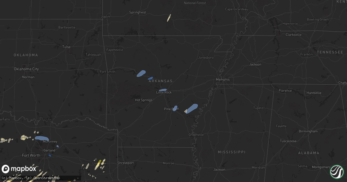
Hail Map in Arkansas on April 30, 2025
Get this storm
April 30 map
$229
one time, instant access
Download today. No call, no setup
Keep the $229
Bought the map and want the full workflow? Apply the entire $229 to a subscription within 7 days. None of it is wasted.
Every map, not just this one
This buys you this map. Subscription and you get every map we run, in the markets you choose from a few cities to whole states to nationwide. Plus real-time alerts the moment a storm fires.
Contact data
Name, contact info, occupancy, even credit band for addresses in the footprint. You go from where it hit to who to call.
Become the source they trust
Unlimited branding weather history reports on demand. You already have the documented answer ready for the property owner, and you are the one who showed up with it.
Property data and RoofTrace estimates
Pull up any address you have got, its value and the exact code rules for that jurisdiction, straight from One Click Code. Then RoofTrace estimates the squares, pitch, and roof value, priced the way you price.
Storm reports in Arkansas
Arkansas
| Date | Description |
|---|---|
| 04/30/20256:59 PM CDT | Power poles and power lines downed and several trees downed. |
| 04/30/20256:48 PM CDT | Trees down and minor structural damage reported just north of herbine. |
| 04/30/20256:44 PM CDT | 59 mph wind gust reported at girder field in pine bluff. |
| 04/30/20256:18 PM CDT | Trees blown on to a house and a fence blown over near cabot community park. |
| 04/30/20256:05 PM CDT | Trees and powerlines blown down on jeff davis street in jacksonville. |
| 04/30/20255:59 PM CDT | Reports of several trees fallen across dallas county road 107. |
| 04/30/20255:57 PM CDT | Trees blown down and fencing blown down in numerous locations in sherwood. |
| 04/30/20255:56 PM CDT | Roof damage to cornerstone bible fellowship church. |
| 04/30/20255:53 PM CDT | Report of tree down on house. |
| 04/30/20255:51 PM CDT | Tree blown over at centennial valley golf course in conway. |
| 04/30/20255:50 PM CDT | Tree blown down on a house. |
| 04/30/20255:45 PM CDT | Mesonet station ard14 i-430 river bridge nb pole 15. |
| 04/30/20255:41 PM CDT | Dallas county road 149 has several trees down across the roadway. |
| 04/30/20255:36 PM CDT | **delayed report** social media picture of a tree that fell on a car in sheridan. |
| 04/30/20255:24 PM CDT | **delayed report** social media picture of a metal barn that sustained roof damage. |
| 04/30/20255:24 PM CDT | **delayed report** social media picture of a metal barn that sustained roof damage. |
| 04/30/20255:04 PM CDT | **delayed report** observation from a personal weather station. |
| 04/30/20255:03 PM CDT | Dispatch report of trees down along hwy 278 in east nevada county. |
| 04/30/20254:41 PM CDT | Numerous trees blown down in hot springs village. |
| 04/30/20254:36 PM CDT | Trees blown down in greenbrier. |
| 04/30/20254:36 PM CDT | A large tree was blown on top of a car crushing it at arkansas tech. |
| 04/30/20254:36 PM CDT | A local report indicates 63 MPH wind near Russellville Regional A |
| 04/30/20254:07 PM CDT | Reports of a tree blocking crabtree ln in bradley. |
| 04/30/20254:07 PM CDT | Reports of multiple trees down on vehicles at a baseball field west of bradley... Ar. |
| 04/30/20254:00 PM CDT | Large tree reported to be blown down. |
| 04/30/20253:52 PM CDT | Chicken house was damaged. |
| 04/30/20253:52 PM CDT | Trees and power lines reported to be down. |
| 04/30/20253:50 PM CDT | **delayed report** state highway 307 state highway 28 in briggsville were blocked due to downed trees. |
| 04/30/20253:29 PM CDT | Tree down at the intersection of highway 160 and county road 3. |
| 04/30/20253:25 PM CDT | This a delayed report. Trees down across smoky hollow road. |
| 04/30/20252:49 PM CDT | 911 dispatch report multiple trees down around howard county. |
| 04/30/20252:30 PM CDT | 911 dispatch reported multiple trees down south of lockesburg... Ar. |
| 04/30/20252:30 PM CDT | County official reported damage to houses... Trees along shady ln. |
| 04/30/20252:08 PM CDT | Significant damage to a chicken house near grannis. |
| 04/30/20252:08 PM CDT | Reports of trees down in foreman... Ar. |
| 04/30/20252:06 PM CDT | Picture via social media shows damage to chicken coops. |
| 04/29/20258:59 PM CDT | A large tree fell down on state highway 242 near the intersection of county road 210. Both lanes of state highway 242 were blocked. |
| 04/29/20258:56 PM CDT | Tree down along highway 70 north of proctor. |
| 04/29/20258:27 PM CDT | Some trees were blown on highway 49 just north of fair oaks. |
| 04/29/20258:17 PM CDT | Powerlines down along highway one in watson. |
| 04/29/20257:44 PM CDT | Personal weather station reported a wind gust of 61 mph. |
All States Impacted by Hail Map on April 30, 2025
Cities Impacted by Hail Map on April 30, 2025
- Bloomingdale, OH
- Clinton, PA
- Jewett, OH
- Georgetown, PA
- Hookstown, PA
- Scio, OH
- Steubenville, OH
- Amsterdam, OH
- New Cumberland, WV
- Richmond, OH
- Hopedale, OH
- Weirton, WV
- Imperial, PA
- Toronto, OH
- Burgettstown, PA
- Bulger, PA
- Bergholz, OH
- Bethesda, OH
- Follansbee, WV
- New Florence, PA
- Williamsburg, PA
- Quaker City, OH
- Dravosburg, PA
- Muncy Valley, PA
- Summerfield, OH
- Cadogan, PA
- Beech Creek, PA
- Hughesville, PA
- West Lebanon, PA
- Oakland Mills, PA
- Montoursville, PA
- Laughlintown, PA
- Luzerne, PA
- McGrann, PA
- New Philadelphia, OH
- Templeton, PA
- Mifflintown, PA
- Newry, PA
- Shavertown, PA
- Turtle Creek, PA
- New Millport, PA
- New Bethlehem, PA
- Strongstown, PA
- Walston, PA
- Unityville, PA
- Renfrew, PA
- Mapleton Depot, PA
- Madison, PA
- Natrona Heights, PA
- Sewickley, PA
- Mifflinburg, PA
- Pitcairn, PA
- Saint Michael, PA
- Bethel Park, PA
- Bairdford, PA
- New Paris, PA
- Cheswick, PA
- Marion Center, PA
- Flinton, PA
- Mars, PA
- Beaverdale, PA
- Bellaire, OH
- Harrison City, PA
- Seward, PA
- Trafford, PA
- Hickory, PA
- Heilwood, PA
- Bellefonte, PA
- Hebron, OH
- Tarrs, PA
- Sidman, PA
- Bunola, PA
- Russellton, PA
- Summitville, OH
- Brisbin, PA
- Eighty Four, PA
- Leesville, OH
- Ebensburg, PA
- Senecaville, OH
- Lanse, PA
- West Finley, PA
- Shamokin, PA
- East Vandergrift, PA
- Avis, PA
- Gallitzin, PA
- Northpoint, PA
- Valier, PA
- Greenock, PA
- Shenandoah, PA
- Ambridge, PA
- Neffs, OH
- Kirkersville, OH
- West Milton, PA
- New Enterprise, PA
- Coshocton, OH
- Cairnbrook, PA
- Stahlstown, PA
- Sagamore, PA
- Brilliant, OH
- Beallsville, PA
- Delaware, OH
- Shickshinny, PA
- Munson, PA
- Madisonburg, PA
- Richfield, PA
- Wickhaven, PA
- Shelocta, PA
- Freedom, PA
- Manor, PA
- Blue Rock, OH
- Emeigh, PA
- Presto, PA
- Starford, PA
- Thornville, OH
- Cocolamus, PA
- Dayton, PA
- Shadyside, OH
- Pennsylvania Furnace, PA
- Dublin, OH
- Forksville, PA
- Cresson, PA
- Roscoe, PA
- Grapeville, PA
- Dillonvale, OH
- Beech Bottom, WV
- Falls, PA
- Robinson, PA
- Wilburton, PA
- Spruce Creek, PA
- Huntington Mills, PA
- Allenport, PA
- Ashville, PA
- Mount Union, PA
- Dalmatia, PA
- Reynoldsburg, OH
- Black Lick, PA
- Bolivar, PA
- Columbus, OH
- West Alexander, PA
- Beaver Falls, PA
- Venetia, PA
- Midvale, OH
- Westland, PA
- Leetsdale, PA
- Wilmerding, PA
- Mcmechen, WV
- Newcomerstown, OH
- New Concord, OH
- Powell, OH
- Claysville, PA
- Acosta, PA
- Elton, PA
- Derry, PA
- South Heights, PA
- Newark, OH
- Moundsville, WV
- Mahaffey, PA
- Wellsburg, WV
- Westover, PA
- Rayland, OH
- Gnadenhutten, OH
- New Alexandria, PA
- Industry, PA
- Houston, PA
- Mehoopany, PA
- Alverda, PA
- Cogan Station, PA
- Linden, PA
- Luthersburg, PA
- Worthington, PA
- Mineral City, OH
- Port Royal, PA
- Export, PA
- Dawson, PA
- Fresno, OH
- Buckeye Lake, OH
- Rochester, PA
- Warrendale, PA
- Milesburg, PA
- Tuscarawas, OH
- Ardara, PA
- Port Matilda, PA
- Middleburg, PA
- Star Junction, PA
- Monessen, PA
- Rock Glen, PA
- Dallas, WV
- Buena Vista, PA
- Clune, PA
- Richeyville, PA
- Liverpool, PA
- Brownsville, PA
- Stoystown, PA
- Glen Dale, WV
- Rillton, PA
- Irvona, PA
- Powhatan Point, OH
- Loyalhanna, PA
- James Creek, PA
- Kipling, OH
- Barnesville, OH
- Glenshaw, PA
- Cambridge, OH
- Cowansville, PA
- Westerville, OH
- New Columbia, PA
- Verona, PA
- Pittston, PA
- Vandergrift, PA
- Bakerstown, PA
- Hopewell, OH
- McDonald, PA
- Monroeville, PA
- Hastings, PA
- Bridgeport, OH
- University Park, PA
- Galloway, OH
- Glen Richey, PA
- Valley Grove, WV
- Beavertown, PA
- Johnstown, OH
- Callery, PA
- Montgomery, PA
- Klingerstown, PA
- Dysart, PA
- Imler, PA
- Clarks Summit, PA
- Centre Hall, PA
- Bloomsburg, PA
- Drifting, PA
- Milroy, PA
- Graysville, PA
- Fenelton, PA
- Arona, PA
- Watsontown, PA
- Slickville, PA
- Dennison, OH
- Coral, PA
- Dilltown, PA
- Portage, PA
- Fleming, PA
- Larimer, PA
- Bentleyville, PA
- Bradenville, PA
- Rural Valley, PA
- Morgan, PA
- Muncy, PA
- Berwick, PA
- Philipsburg, PA
- Thompsontown, PA
- Laurelton, PA
- Benwood, WV
- Moosic, PA
- La Jose, PA
- Bovard, PA
- Harwick, PA
- Moshannon, PA
- Saint Boniface, PA
- California, PA
- Windsor Heights, WV
- Saxton, PA
- State College, PA
- Avella, PA
- Beaver Springs, PA
- Mechanicstown, OH
- Queen, PA
- Altoona, PA
- Sunbury, PA
- Hollsopple, PA
- Elderton, PA
- Zelienople, PA
- Ellwood City, PA
- Wilmore, PA
- Houtzdale, PA
- Orviston, PA
- Lewisburg, PA
- Aliquippa, PA
- Mount Carmel, PA
- Jeannette, PA
- Clarence, PA
- Muse, PA
- Selinsgrove, PA
- Pleasant City, OH
- Braddock, PA
- Josephine, PA
- Woodsfield, OH
- Wyoming, PA
- Northumberland, PA
- Smithmill, PA
- Lock Haven, PA
- Stone Creek, OH
- Montandon, PA
- Harleigh, PA
- Alum Bank, PA
- Stratton, OH
- North Versailles, PA
- Nanticoke, PA
- Duquesne, PA
- Cadiz, OH
- Champion, PA
- Cecil, PA
- Wilkes Barre, PA
- Dellroy, OH
- Granville, PA
- Heath, OH
- Central City, PA
- Pleasant Unity, PA
- Ashland, PA
- Darragh, PA
- Summerhill, PA
- Wapwallopen, PA
- Dallas, PA
- Tiltonsville, OH
- Pitman, PA
- Dixonville, PA
- Alverton, PA
- Cuddy, PA
- Sandy Ridge, PA
- Ligonier, PA
- Yukon, PA
- Beccaria, PA
- Dornsife, PA
- Midland, PA
- White Deer, PA
- Curwensville, PA
- New Derry, PA
- Carrolltown, PA
- Donora, PA
- Belle Vernon, PA
- Shippingport, PA
- Yatesboro, PA
- Kimbolton, OH
- Homer City, PA
- Mount Pleasant Mills, PA
- Webster, PA
- Warriors Mark, PA
- Van Voorhis, PA
- Kittanning, PA
- Scenery Hill, PA
- Hollidaysburg, PA
- Cherry Tree, PA
- Clarksburg, PA
- Freeport, OH
- Plymouth, PA
- Osceola Mills, PA
- Monaca, PA
- Leechburg, PA
- Mill Creek, PA
- Hanoverton, OH
- West Lafayette, OH
- Saint Clairsville, OH
- Darlington, PA
- Perryopolis, PA
- Uhrichsville, OH
- Lewisville, OH
- Smithfield, OH
- Caldwell, OH
- Philo, OH
- Wyano, PA
- McAlisterville, PA
- Conyngham, PA
- Wexford, PA
- Hesston, PA
- Tippecanoe, OH
- New Manchester, WV
- Glen Campbell, PA
- Friedens, PA
- West Jefferson, OH
- Ramey, PA
- Adrian, PA
- Morristown, OH
- Hammondsville, OH
- Plain City, OH
- Coal Township, PA
- Belsano, PA
- Sweet Valley, PA
- Patton, PA
- Wallaceton, PA
- Pittsburgh, PA
- Elmora, PA
- Fallentimber, PA
- Scottdale, PA
- Nineveh, PA
- Sugarloaf, PA
- Commodore, PA
- Lewis Center, OH
- Herminie, PA
- Warsaw, OH
- Ruffs Dale, PA
- Clearfield, PA
- Adena, OH
- East Liverpool, OH
- Lore City, OH
- Jacobsburg, OH
- Mount Pleasant, OH
- White, PA
- Fredericktown, PA
- Donegal, PA
- Eagles Mere, PA
- Clymer, PA
- Freeland, PA
- Saltsburg, PA
- Morrisdale, PA
- Martinsburg, PA
- Lairdsville, PA
- Millerstown, PA
- Hillsgrove, PA
- Midway, PA
- Aultman, PA
- Sarver, PA
- Allenwood, PA
- Clairton, PA
- Belleville, PA
- Trinway, OH
- Joffre, PA
- Hyde Park, PA
- Todd, PA
- Mineral Point, PA
- Lawrence, PA
- White Haven, PA
- Gray, PA
- Flushing, OH
- Carrollton, OH
- Smicksburg, PA
- Stillwater, PA
- Mountain Top, PA
- Vanderbilt, PA
- Bowerston, OH
- Langeloth, PA
- New Stanton, PA
- Nanty Glo, PA
- McIntyre, PA
- West Decatur, PA
- Cumberland, OH
- Davidsville, PA
- Rector, PA
- Etna, OH
- Tipton, PA
- Newell, PA
- Somerset, PA
- Grampian, PA
- Elco, PA
- Valencia, PA
- Belmont, OH
- Millmont, PA
- Leck Kill, PA
- Pine Grove Mills, PA
- Burnside, PA
- Herndon, PA
- Tyrone, PA
- Mifflinville, PA
- Cabot, PA
- Plainfield, OH
- Ringtown, PA
- Coal Center, PA
- Hostetter, PA
- New Eagle, PA
- Charleroi, PA
- Fombell, PA
- Sheppton, PA
- Duncansville, PA
- Rossiter, PA
- Triadelphia, WV
- Karthaus, PA
- Grassflat, PA
- Hilliard, OH
- Blandburg, PA
- Hyde, PA
- Olanta, PA
- West Liberty, WV
- Glen Lyon, PA
- Grindstone, PA
- Connellsville, PA
- Cameron, WV
- Mount Perry, OH
- Apollo, PA
- Blacklick, OH
- Jerusalem, OH
- Hunlock Creek, PA
- Forbes Road, PA
- Salesville, OH
- Orangeville, PA
- Trevorton, PA
- Yeagertown, PA
- South Park, PA
- Turbotville, PA
- Nuremberg, PA
- Laporte, PA
- Dushore, PA
- McEwensville, PA
- Hamilton, PA
- Millheim, PA
- New Kensington, PA
- Dalton, PA
- Factoryville, PA
- Entriken, PA
- Millersport, OH
- Seanor, PA
- Connoquenessing, PA
- Jones Mills, PA
- Pataskala, OH
- Freeport, PA
- Bethany, WV
- Jacksontown, OH
- Bigler, PA
- Fayette City, PA
- Roaring Spring, PA
- Lowber, PA
- Lisbon, OH
- Washington, PA
- Huntingdon, PA
- Gibsonia, PA
- Penn Run, PA
- Mineral Springs, PA
- Allport, PA
- Springdale, PA
- Catawissa, PA
- Creighton, PA
- West Newton, PA
- Roseville, OH
- Home, PA
- Wheeling, WV
- Alexandria, PA
- Loganton, PA
- Armagh, PA
- Colver, PA
- Ford Cliff, PA
- Burnham, PA
- Manorville, PA
- Oakmont, PA
- Spring Church, PA
- Alledonia, OH
- Millville, PA
- Mill Hall, PA
- Jerome, PA
- Wampum, PA
- Salineville, OH
- Adamsburg, PA
- Conesville, OH
- Southview, PA
- Arcadia, PA
- Newell, WV
- Hazleton, PA
- Avonmore, PA
- Saint Benedict, PA
- Delmont, PA
- Woodbury, PA
- Lilly, PA
- Sutersville, PA
- Byesville, OH
- Blanchard, PA
- Tarentum, PA
- Kensington, OH
- Duncan Falls, OH
- Sturgeon, PA
- Jersey Shore, PA
- Cokeburg, PA
- Strabane, PA
- Gipsy, PA
- Drums, PA
- Spring Mills, PA
- West Mifflin, PA
- Spangler, PA
- Piedmont, OH
- Colliers, WV
- West Elizabeth, PA
- Alexandria, OH
- Bear Creek, PA
- Milton, PA
- Evans City, PA
- Nescopeck, PA
- Williamsport, PA
- Glassport, PA
- Penn, PA
- Madera, PA
- Zanesville, OH
- Sproul, PA
- Acme, PA
- Northern Cambria, PA
- Amlin, OH
- Howard, PA
- Norwich, OH
- Lucernemines, PA
- Quecreek, PA
- Lemont, PA
- Blairsville, PA
- Martins Ferry, OH
- Yorkville, OH
- Beallsville, OH
- Cranberry Township, PA
- Tunkhannock, PA
- Aaronsburg, PA
- Kulpmont, PA
- Greensburg, PA
- Claysburg, PA
- North Apollo, PA
- Snow Shoe, PA
- Oakdale, PA
- Glenford, OH
- Saxonburg, PA
- Finleyville, PA
- Chest Springs, PA
- Freeburg, PA
- Mentcle, PA
- New Albany, OH
- Harmony, PA
- Lamar, PA
- Glen Hope, PA
- Elysburg, PA
- Bridgeville, PA
- Nicktown, PA
- Winfield, PA
- Homestead, PA
- Woodland, PA
- Sycamore, PA
- Coalport, PA
- East McKeesport, PA
- Irondale, OH
- East Pittsburgh, PA
- Prosperity, PA
- Crabtree, PA
- Saint Louisville, OH
- Monongahela, PA
- Everson, PA
- Kingston, PA
- Hannastown, PA
- Mifflin, PA
- Sarahsville, OH
- Old Washington, OH
- Brush Valley, PA
- Ford City, PA
- Negley, OH
- Beaver, PA
- Boswell, PA
- Utica, OH
- Petersburg, PA
- Noxen, PA
- Jenners, PA
- New Brighton, PA
- Mckeesport, PA
- Murrysville, PA
- Trout Run, PA
- Parkhill, PA
- Canonsburg, PA
- New Berlin, PA
- Adamsville, OH
- Port Washington, OH
- East Freedom, PA
- Galena, OH
- Sherrodsville, OH
- Indianola, PA
- Irwin, PA
- Creekside, PA
- Rochester Mills, PA
- Frenchville, PA
- Osterburg, PA
- Indiana, PA
- Marianna, PA
- Reedsville, PA
- Empire, OH
- White Cottage, OH
- Bellwood, PA
- Julian, PA
- Wellsville, OH
- Frazeysburg, OH
- Conway, PA
- Punxsutawney, PA
- Baltimore, OH
- Allensville, PA
- Daisytown, PA
- Danville, PA
- Mount Pleasant, PA
- Loretto, PA
- Youngstown, PA
- Dresden, OH
- Hillsdale, PA
- McClure, PA
- Claridge, PA
- Chester, WV
- Dunlevy, PA
- Windber, PA
- Westmoreland City, PA
- Big Run, PA
- Port Trevorton, PA
- New Galilee, PA
- Hooversville, PA
- Atlasburg, PA
- Cassandra, PA
- Zion Grove, PA
- Carnegie, PA
- Ernest, PA
- Nashport, OH
- Smithton, PA
- McVeytown, PA
- Duryea, PA
- Marion Heights, PA
- Brackenridge, PA
- Stockdale, PA
- Allison Park, PA
- Elrama, PA
- Luxor, PA
- Rebersburg, PA
- Mingo Junction, OH
- Youngwood, PA
- Woodward, PA
- Boalsburg, PA
- East Palestine, OH
- McKees Rocks, PA
- Coburn, PA
- Rebuck, PA
- Twin Rocks, PA
- Marsteller, PA
- Meadow Lands, PA
- Butler, PA
- Riverside, PA
- Granville, OH
- Slovan, PA
- Winburne, PA
- East Springfield, OH
- Bradfordwoods, PA
- Paxinos, PA
- Lopez, PA
- Benton, PA
- Mildred, PA
- Lewistown, PA
- Chandlersville, OH
- Baden, PA
- Kylertown, PA
- Amity, PA
- South Fork, PA
- Old Forge, PA
- Johnstown, PA
- Latrobe, PA
- Jennerstown, PA
- Vintondale, PA
- Shamokin Dam, PA
- Coraopolis, PA
- Hawk Run, PA
- Harveys Lake, PA
- Elizabeth, PA
- Salix, PA
- Ellsworth, PA
- Hunker, PA
- Locust Gap, PA
- Rogers, OH
- Crescent, PA
- Sunbury, OH
- Loving, TX
- Jermyn, TX
- Bryson, TX
- Jacksboro, TX
- Graham, TX
- Alvord, TX
- Decatur, TX
- Chico, TX
- Bridgeport, TX
- Era, TX
- Valley View, TX
- Krum, TX
- Gainesville, TX
- Sanger, TX
- Denton, TX
- Aubrey, TX
- Celina, TX
- Pilot Point, TX
- Prosper, TX
- Mckinney, TX
- Dublin, TX
- Gustine, TX
- Carlton, TX
- Hico, TX
- Glen Rose, TX
- Oakdale, TN
- Wartburg, TN
- Mullin, TX
- Grandview, TX
- Comanche, TX
- Zephyr, TX
- Milford, TX
- Italy, TX
- Early, TX
- Maypearl, TX
- Bluff Dale, TX
- Hamilton, TX
- Blooming Grove, TX
- Priddy, TX
- Hillsboro, TX
- Ennis, TX
- Dawson, TX
- Purdon, TX
- Frost, TX
- Waco, KY
- Kopperl, TX
- Iredell, TX
- Walnut Springs, TX
- Corsicana, TX
- Barry, TX
- Wortham, TX
- Richland, TX
- Waco, TX
- Axtell, TX
- Elm Mott, TX
- West, TX
- Tyler, TX
- Muleshoe, TX
- Winona, TX
- Bremond, TX
- Littlefield, TX
- Parkers Lake, KY
- Kerens, TX
- Morgan, TX
- Coolidge, TX
- Hubbard, TX
- Mount Calm, TX
- Alvarado, TX
- Cleburne, TX
- Kilgore, TX
- Longview, TX
- Hallsville, TX
- Kosse, TX
- Reagan, TX
- Mart, TX
- Overton, TX
- Riesel, TX
- Keene, TX
- Erwin, TN
- Prairie Hill, TX
- Anton, TX
- Abernathy, TX
- Shallowater, TX
- Gatesville, TX
- Thornton, TX
- Marshall, TX
- Lubbock, TX
- Mexia, TX
- Smithton, IL
- Crawford, TX
- McGregor, TX
- Gilmer, TX
- Gladewater, TX
- Henderson, TX
- Marlin, TX
- Oglesby, TX
- Tatum, TX
- New Deal, TX
- Freeburg, IL
- Teague, TX
- Donie, TX
- Groesbeck, TX
- Rosebud, TX
- Belleville, IL
- Lott, TX
- Washington, IN
- Venus, TX
- Slaton, TX
- Lorenzo, TX
- Idalou, TX
- Jackson, KY
- Montgomery, IN
- Thurmond, NC
- Dobson, NC
- Mount Airy, NC
- Woodway, TX
- Fairfield, TX
- Moody, TX
- Cannelburg, IN
- Mascoutah, IL
- Lebanon, IL
- Trenton, IL
- Ralls, TX
- Evant, TX
- Campton, KY
- Vancleve, KY
- Lorena, TX
- New Baden, IL
- Loogootee, IN
- Crosbyton, TX
- Dickens, TX
- Afton, TX
- Mcadoo, TX
- Bartelso, IL
- Charlotte, TX
- Silverton, TX
- Purmela, TX
- Elkin, NC
- Hazel Green, KY
- Hewitt, TX
- Shoals, IN
- Aviston, IL
- Jourdanton, TX
- Lampasas, TX
- Germantown, IL
- Mize, KY
- Valley Mills, TX
- Kempner, TX
- Mitchell, IN
- Clifton, TX
- Pleasanton, TX
- Copperas Cove, TX
- Jonesboro, TX
- Whitney, TX
- Breese, IL
- China Spring, TX
- Spur, TX
- Vanzant, MO
- Carlyle, IL
- Saint Charles, MO
- Defiance, MO
- O'Fallon, MO
- Hooker, OK
- Willow Springs, MO
- Aquilla, TX
- Lake Saint Louis, MO
- Williams, IN
- Jewett, TX
- Versailles, KY
- Poteet, TX
- Cynthiana, KY
- Larned, KS
- St John, KS
- Sadieville, KY
- Fort Hood, TX
- Girard, TX
- Killeen, TX
- Harker Heights, TX
- Abbott, TX
- Jayton, TX
- Cabool, MO
- New Athens, IL
- Meridian, TX
- San Antonio, TX
- Elmendorf, TX
- Chesterfield, MO
- Saint Albans, MO
- Pacific, MO
- Wildwood, MO
- Falls City, TX
- Aspermont, TX
- Campbellton, TX
- Okawville, IL
- Addieville, IL
- Snyder, TX
- Bedford, IN
- Odon, IN
- Nolanville, TX
- Keyesport, IL
- Belton, TX
- Temple, TX
- Old Glory, TX
- Streetman, TX
- Owenton, KY
- Burnet, TX
- Lockport, KY
- Bethlehem, KY
- Buffalo, TX
- Rule, TX
- Shobonier, IL
- Medora, IN
- Norman, IN
- Vandalia, IL
- Vernon, IL
- Balko, OK
- Eddy, TX
- Troy, TX
- Oakwood, TX
- Haskell, TX
- Chilton, TX
- El Portal, CA
- McDonald, KS
- Georgetown, KY
- Brownstown, IL
- Arnold, NE
- Dunning, NE
- Salado, TX
- Crane, IN
- Karnes City, TX
- Wentzville, MO
- Three Rivers, TX
- Whitsett, TX
- Colby, KS
- Vallonia, IN
- Austin, IN
- Crothersville, IN
- Corinth, KY
- Bruceville, TX
- Little River Academy, TX
- Floresville, TX
- Edson, KS
- Brewster, KS
- Masterson, TX
- Fritch, TX
- Delaware, AR
- Dardanelle, AR
- Kenedy, TX
- Russellville, AR
- Liberty Hill, TX
- Florence, TX
- Georgetown, TX
- Bertram, TX
- Brownstown, IN
- Levant, KS
- Adkins, TX
- Paris Crossing, IN
- Deputy, IN
- Holland, TX
- Williamstown, KY
- Jarrell, TX
- Troup, TX
- Rogers, TX
- Stamford, TX
- Avoca, TX
- Bartlett, TX
- Scottsburg, IN
- North Platte, NE
- Spearman, TX
- Seymour, IN
- Commiskey, IN
- Witt, IL
- Nokomis, IL
- Gillett, AR
- De Witt, AR
- Stuttgart, AR
- Lueders, TX
- Albany, TX
- Throckmorton, TX
- Woodson, TX
- Beeville, TX
- Perryton, TX
- Franklin, TX
- Maxwell, NE
- Springville, IN
- Owensburg, IN
- Tennessee Colony, TX
- Montalba, TX
- Irving, IL
- Elsie, NE
- Owaneco, IL
- Pana, IL
- Rosamond, IL
- Morrisonville, IL
- Hayes Center, NE
- North Vernon, IN
- Marquez, TX
- Granger, TX
- Flat Rock, IL
- Neoga, IL
- Trilla, IL
- Palestine, IL
- Tribune, KS
- Buckholts, TX
- Calvert, TX
- Carlisle, IN
- Palestine, TX
- Jacksonville, TX
- Rusk, TX
- Burlington, TX
- Assumption, IL
- Freetown, IN
- Elkhart, TX
- Frankston, TX
- Merom, IN
- Burlington, KY
- Union, KY
- Rising Sun, IN
- Butlerville, IN
- Dupont, IN
- Thorndale, TX
- Virden, IL
- Auburn, IL
- Thayer, IL
- Florence, KY
- Stinnett, TX
- Walton, KY
- Erlanger, KY
- Independence, KY
- Ft Mitchell, KY
- Latonia, KY
- Fargo, OK
- Oblong, IL
- Laneville, TX
- Normangee, TX
- Grapeland, TX
- Glenarm, IL
- Chatham, IL
- Gause, TX
- Hearne, TX
- Oakley, KS
- Hutto, TX
- Taylor, TX
- Leona, TX
- Centerville, TX
- Syracuse, KS
- Oakland, IL
- Ashmore, IL
- Bryan, TX
- Alexandria, KY
- Newport, KY
- Deerfield, KS
- Lakin, KS
- Morning View, KY
- Madisonville, TX
- Patriot, IN
- Crockett, TX
- Annapolis, IL
- Midway, TX
- Melbourne, KY
- California, KY
- Round Rock, TX
- New Richmond, OH
- Amelia, OH
- Goliad, TX
- Bethel, OH
- Lovelady, TX
- Bird City, KS
- Pflugerville, TX
- Leander, TX
- Beckville, TX
- Gove, KS
- Manor, TX
- Coupland, TX
- De Land, IL
- Cisco, IL
- Alto, TX
- Kennard, TX
- Williamsburg, OH
- Monticello, IL
- Elgin, TX
- Thrall, TX
- Apple Springs, TX
- Mansfield, IL
- Farmer City, IL
- Rockdale, TX
- Bellflower, IL
- Fisher, IL
- Lufkin, TX
- Mahomet, IL
- Pollok, TX
- Foosland, IL
- Bedias, TX
- Diboll, TX
- Denison, TX
- Hendrix, OK
- Bells, TX
- Milford, IL
- Ambia, IN
- Somerville, TX
- Navasota, TX
- College Station, TX
- Anderson, TX
- Montgomery, TX
- Paris, KY
- Gardner, IL
- Carlisle, KY
- Saint Hedwig, TX
- Marion, TX
- Converse, TX
- Blanchester, OH
- Fayetteville, OH
- Divernon, IL
- Pawnee, IL
- Springfield, IL
- Rochester, IL
- Midland, OH
- Wilmington, OH
- Bon Wier, TX
- West Liberty, KY
- Starks, LA
- Merryville, LA
- Dover, AR
- London, AR
- Hector, AR
- Morrilton, AR
- Atkins, AR
- Little Rock, AR
- North Little Rock, AR
- Maumelle, AR
- Sherwood, AR
- Singer, LA
- Pine Bluff, AR
- Sherrill, AR
- Altheimer, AR
- Grady, AR
- Wabbaseka, AR
- Dequincy, LA
- Tichnor, AR
- Ethel, AR
- Saint Charles, AR
- Elaine, AR
- Holly Grove, AR
- Longville, LA
- Sylvania, OH
- Ottawa Lake, MI
- Blissfield, MI
- Berkey, OH
- Ragley, LA
- Petersburg, MI
- Riga, MI
- Dry Creek, LA
- Westlake, LA
- Lake Charles, LA
- Kinder, LA
- Oberlin, LA
- Iowa, LA
- Bell City, LA
- Welsh, LA
- Jennings, LA
- Roanoke, LA
- Mesquite, TX
- Dallas, TX
- Balch Springs, TX
- Nevada, TX
- Royse City, TX
- Caddo Mills, TX


