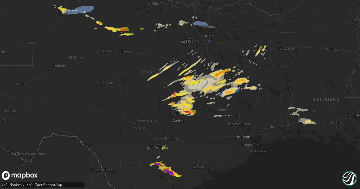
Hail Map on April 30, 2025
Get this storm
April 30 map
$229
one time, instant access
Download today. No call, no setup
Keep the $229
Bought the map and want the full workflow? Apply the entire $229 to a subscription within 7 days. None of it is wasted.
Every map, not just this one
This buys you this map. Subscription and you get every map we run, in the markets you choose from a few cities to whole states to nationwide. Plus real-time alerts the moment a storm fires.
Contact data
Name, contact info, occupancy, even credit band for addresses in the footprint. You go from where it hit to who to call.
Become the source they trust
Unlimited branding weather history reports on demand. You already have the documented answer ready for the property owner, and you are the one who showed up with it.
Property data and RoofTrace estimates
Pull up any address you have got, its value and the exact code rules for that jurisdiction, straight from One Click Code. Then RoofTrace estimates the squares, pitch, and roof value, priced the way you price.
States Impacted by Hail Map on April 30, 2025
Storm reports
Kentucky
| Date | Description |
|---|---|
| 04/30/20256:56 PM CDT | A local report indicates 1.50 inch wind near Owenton |
| 04/30/20256:40 PM CDT | Report from mping: quarter |
| 04/30/20256:25 PM CDT | Report of between pea and quarter sized hail along ky 392 east of cynthiana. |
| 04/30/20256:05 PM CDT | A local report indicates 1.00 inch wind near Cynthiana |
| 04/30/20256:04 PM CDT | Mostly nickel size hail and occasional quarter size hail. |
| 04/30/20255:24 PM CDT | Social media reported quarter sized hail near grassy creek... Morgan county. Time estimated by radar. |
| 04/29/20259:35 PM CDT | Near intersection of brightleaf blvd. And turkeyfoot road. Time estimated. |
Missouri
| Date | Description |
|---|---|
| 04/30/20255:46 PM CDT | A local report indicates 1.00 inch wind near 1 W O'Fallon |
| 04/30/20255:41 PM CDT | At least quarter sized hail. |
North Carolina
| Date | Description |
|---|---|
| 04/30/20255:12 PM CDT | Thunderstorm winds blew down one tree near the intersection of old us route 601 and perry taylor road. |
| 04/30/20255:06 PM CDT | Thunderstorm winds blew down one tree near the intersection of cadle ford road and red brush road. |
| 04/30/20254:54 PM CDT | Thunderstorm winds blew down one tree along the 1400 block of judsville school road close to the intersection with racoon lane. |
| 04/30/20254:17 PM CDT | Thunderstorm winds blew down one tree near the intersection of us route 601 and chandler road. |
Colorado
| Date | Description |
|---|---|
| 04/30/20256:49 PM CDT | Asos station klaa lamar airport. |
Illinois
| Date | Description |
|---|---|
| 04/30/20255:21 PM CDT | Media reporting photo of 1.5-2.0 inch hail on social media. Time estimated from radar. |
| 04/30/20255:20 PM CDT | A local report indicates 1.00 inch wind near 1 S Aviston |
| 04/30/20255:05 PM CDT | A local report indicates 1.00 inch wind near 1 SSE Trenton |
| 04/29/20259:39 PM CDT | A local report indicates 1.00 inch wind near Chatham |
| 04/29/20259:03 PM CDT | Picture evidence of a tornado touching down. No damage reported. |
| 04/29/20258:34 PM CDT | A local report indicates 1.00 inch wind near 1 NE Rosamond |
| 04/29/20258:30 PM CDT | Delayed report. Time estimated from radar. |
| 04/29/20258:14 PM CDT | Several videos of the tornado touching down just north of effingham for about 1.5 miles. No damage reported. |
| 04/29/20258:14 PM CDT | A brief touchdown of a tornado north of effingham. Relayed via social media. |
Indiana
| Date | Description |
|---|---|
| 04/30/20256:12 PM CDT | Williams dam co-op observer reports 1 inch hail. |
| 04/30/20255:32 PM CDT | Received pictures of report. |
| 04/30/20255:28 PM CDT | A local report indicates 1.75 inch wind near Shoals |
| 04/30/20255:22 PM CDT | A local report indicates 1.25 inch wind near 1 NW Loogootee |
| 04/30/20254:40 PM CDT | A local report indicates 1.00 inch wind near 5 SE Washington |
| 04/30/20254:39 PM CDT | Report from mping: quarter |
| 04/30/20254:36 PM CDT | Public report received from x. |
| 04/29/20258:03 PM CDT | Report from media. Time based upon radar. |
| 04/29/20257:30 PM CDT | A local report indicates 1.00 inch wind near Burns City |
Louisiana
| Date | Description |
|---|---|
| 04/30/20254:50 PM CDT | Social media report of multiple trees and power lines down north of shongaloo. |
| 04/30/20251:57 AM CDT | Trees downed near the intersection of la 500 and la 472. |
| 04/30/20251:53 AM CDT | Trees down near the intersection of hwy. 123 and us hwy. 167. |
| 04/30/20251:48 AM CDT | Trees down near the intersection of us hwy 167 and la 472. |
| 04/30/20251:30 AM CDT | Trees down near us. 167 and pacton-alexandria road. |
Mississippi
| Date | Description |
|---|---|
| 04/29/20259:01 PM CDT | Measured by a davis weather station southeast of shelby. |
Oklahoma
| Date | Description |
|---|---|
| 04/30/202510:55 AM CDT | Damage to trees and building roofs. Photos relayed via social media. |
| 04/30/20259:45 AM CDT | Roof damage to a house. |
Arkansas
| Date | Description |
|---|---|
| 04/30/20256:59 PM CDT | Power poles and power lines downed and several trees downed. |
| 04/30/20256:48 PM CDT | Trees down and minor structural damage reported just north of herbine. |
| 04/30/20256:44 PM CDT | 59 mph wind gust reported at girder field in pine bluff. |
| 04/30/20256:18 PM CDT | Trees blown on to a house and a fence blown over near cabot community park. |
| 04/30/20256:05 PM CDT | Trees and powerlines blown down on jeff davis street in jacksonville. |
| 04/30/20255:59 PM CDT | Reports of several trees fallen across dallas county road 107. |
| 04/30/20255:57 PM CDT | Trees blown down and fencing blown down in numerous locations in sherwood. |
| 04/30/20255:56 PM CDT | Roof damage to cornerstone bible fellowship church. |
| 04/30/20255:53 PM CDT | Report of tree down on house. |
| 04/30/20255:51 PM CDT | Tree blown over at centennial valley golf course in conway. |
| 04/30/20255:50 PM CDT | Tree blown down on a house. |
| 04/30/20255:45 PM CDT | Mesonet station ard14 i-430 river bridge nb pole 15. |
| 04/30/20255:41 PM CDT | Dallas county road 149 has several trees down across the roadway. |
| 04/30/20255:36 PM CDT | **delayed report** social media picture of a tree that fell on a car in sheridan. |
| 04/30/20255:24 PM CDT | **delayed report** social media picture of a metal barn that sustained roof damage. |
| 04/30/20255:24 PM CDT | **delayed report** social media picture of a metal barn that sustained roof damage. |
| 04/30/20255:04 PM CDT | **delayed report** observation from a personal weather station. |
| 04/30/20255:03 PM CDT | Dispatch report of trees down along hwy 278 in east nevada county. |
| 04/30/20254:41 PM CDT | Numerous trees blown down in hot springs village. |
| 04/30/20254:36 PM CDT | A local report indicates 63 MPH wind near Russellville Regional A |
| 04/30/20254:36 PM CDT | A large tree was blown on top of a car crushing it at arkansas tech. |
| 04/30/20254:36 PM CDT | Trees blown down in greenbrier. |
| 04/30/20254:07 PM CDT | Reports of a tree blocking crabtree ln in bradley. |
| 04/30/20254:07 PM CDT | Reports of multiple trees down on vehicles at a baseball field west of bradley... Ar. |
| 04/30/20254:00 PM CDT | Large tree reported to be blown down. |
| 04/30/20253:52 PM CDT | Chicken house was damaged. |
| 04/30/20253:52 PM CDT | Trees and power lines reported to be down. |
| 04/30/20253:50 PM CDT | **delayed report** state highway 307 state highway 28 in briggsville were blocked due to downed trees. |
| 04/30/20253:29 PM CDT | Tree down at the intersection of highway 160 and county road 3. |
| 04/30/20253:25 PM CDT | This a delayed report. Trees down across smoky hollow road. |
| 04/30/20252:49 PM CDT | 911 dispatch report multiple trees down around howard county. |
| 04/30/20252:30 PM CDT | County official reported damage to houses... Trees along shady ln. |
| 04/30/20252:30 PM CDT | 911 dispatch reported multiple trees down south of lockesburg... Ar. |
| 04/30/20252:08 PM CDT | Significant damage to a chicken house near grannis. |
| 04/30/20252:08 PM CDT | Reports of trees down in foreman... Ar. |
| 04/30/20252:06 PM CDT | Picture via social media shows damage to chicken coops. |
| 04/29/20258:59 PM CDT | A large tree fell down on state highway 242 near the intersection of county road 210. Both lanes of state highway 242 were blocked. |
| 04/29/20258:56 PM CDT | Tree down along highway 70 north of proctor. |
| 04/29/20258:27 PM CDT | Some trees were blown on highway 49 just north of fair oaks. |
| 04/29/20258:17 PM CDT | Powerlines down along highway one in watson. |
| 04/29/20257:44 PM CDT | Personal weather station reported a wind gust of 61 mph. |
Texas
| Date | Description |
|---|---|
| 04/30/20256:49 PM CDT | Report from mping: half dollar |
| 04/30/20256:44 PM CDT | Report from mping: ping pong ball |
| 04/30/20256:32 PM CDT | Report from mping: quarter |
| 04/30/20256:26 PM CDT | Report from mping. |
| 04/30/20256:19 PM CDT | Report from mping. |
| 04/30/20256:17 PM CDT | A local report indicates 1.00 inch wind near 5 SE China Grove |
| 04/30/20256:16 PM CDT | Report from mping. |
| 04/30/20256:12 PM CDT | Report from mping. |
| 04/30/20256:04 PM CDT | A local report indicates 1.50 inch wind near 4 SE Girard |
| 04/30/20256:00 PM CDT | A local report indicates 1.00 inch wind near Pleasanton |
| 04/30/20255:59 PM CDT | Report from mping. |
| 04/30/20255:55 PM CDT | A local report indicates 1.00 inch wind near 3 SE Girard |
| 04/30/20255:52 PM CDT | Report from mping. |
| 04/30/20255:51 PM CDT | Half dollar size hail in clifton. Relayed via clifton pd. |
| 04/30/20255:50 PM CDT | Delayed report from picture received from media. |
| 04/30/20255:46 PM CDT | Report from mping. |
| 04/30/20255:33 PM CDT | Corrected location. Golf ball to tennis ball size hail reported by inks lake state park official in copperas cove at hillside dr and high chapparal drive. |
| 04/30/20255:33 PM CDT | A local report indicates 64 MPH wind near 3 N Roaring Springs |
| 04/30/20255:33 PM CDT | Golf ball to tennis ball size hail reported by inks lake state park official in copperas cove. |
| 04/30/20255:30 PM CDT | 1.25 inch hail at high chapparal dr and hillside st in copperas cove. |
| 04/30/20255:30 PM CDT | A local report indicates 2.50 inch wind near Jourdanton |
| 04/30/20255:27 PM CDT | Half dollar size hail at fm 116 and us 190. |
| 04/30/20255:13 PM CDT | A local report indicates 63 MPH wind near 3 NNW Mcadoo |
| 04/30/20255:02 PM CDT | A local report indicates 1.00 inch wind near 10 ENE Fairfield |
| 04/30/20254:49 PM CDT | Additional gusts ranging from 59 mph to 62 mph measured from 450 pm to 453 pm. |
| 04/30/20254:43 PM CDT | Dispatch report of trees down near overton. |
| 04/30/20254:37 PM CDT | A wall collapsed on a building in downtown groesbeck on navasota street. No injuries. |
| 04/30/20254:22 PM CDT | A local report indicates 60 MPH wind near Lubbock Int. Airport |
| 04/30/20254:11 PM CDT | [landspout] landspout observed from lubbock international airport. |
| 04/30/20254:09 PM CDT | Report from mping: half dollar |
| 04/30/20254:07 PM CDT | Report from mping: quarter |
| 04/30/20254:03 PM CDT | [landspout] landspout spotted near shallowater. |
| 04/30/20254:01 PM CDT | Report of quarter sized hail at intersection of east loop 218 and alpine rd. |
| 04/30/20254:00 PM CDT | Report of quarter sized hail near west avalon ave in longview. |
| 04/30/20254:00 PM CDT | Ping pong size hail at longview pd. |
| 04/30/20253:58 PM CDT | Report of ping pong sized hail near christus hospital in longview. |
| 04/30/20253:33 PM CDT | [landspout] multiple sightings of a weak landspout south of anton. Location estimated from radar. |
| 04/30/20252:37 PM CDT | Dispatch report of trees down near s cypress st. |
| 04/30/20251:50 PM CDT | 1.00 inch 1s of democrat. |
| 04/30/20251:28 PM CDT | Corrects previous funnel cloud report from 2 nw mertens. Video of a brief tornado near mertens that appeared to be over a field. No damage was reported. This tornado wa |
| 04/30/202512:00 PM CDT | Several homes suffered shingle and fence damage in josephine. |
| 04/30/202511:43 AM CDT | Several homes had parts of roofs blown off or were damaged by fallen trees on meadowbrook drive. |
| 04/30/202511:05 AM CDT | Significant removal of metal roofing and partial removal of roof decking on a home off of cr 35650 1 mile west of fm 1499. Time estimated from radar. |
| 04/30/20259:48 AM CDT | 68 mph wind gust at dallas north tollway and hwy 428. |
| 04/30/20259:46 AM CDT | Downed trees were reported along dartmoor drive... Mustang trail... And saddlebred trail in the carter ranch subdivision... And a downed power line was at coit road and |
| 04/30/20259:37 AM CDT | Picture and video evidence confirmed a brief tornado west of celina. Minor tree damage was found along county road 9. This tornado was rated ef-0 with maximum estimated |
| 04/30/20258:18 AM CDT | Large tree limbs blown down at a home near cr 3336 at fm 2123. |
| 04/29/202511:00 PM CDT | One tree down blocking both lanes at fm 227 near cr1165... North of ratcliff. |
| 04/29/202510:50 PM CDT | Tree branches down... Blocking roads near weldon. |
| 04/29/202510:44 PM CDT | A local report indicates 1.25 inch wind near 2 NW Taylor |
| 04/29/202510:40 PM CDT | Tennis ball sized hail observed near taylor high school. |
| 04/29/202510:30 PM CDT | A local report indicates 1.75 inch wind near 1 NE Hutto |
| 04/29/202510:29 PM CDT | Report from mping. |
| 04/29/202510:28 PM CDT | A local report indicates 1.00 inch wind near 3 S Hutto |
| 04/29/202510:25 PM CDT | Multiple trees down west of austonio. A secondary roof over a trailer house was blown off. |
| 04/29/202510:03 PM CDT | Facebook report of several trees down on hwy 75 in leona. |
| 04/29/202510:01 PM CDT | Stormchaser reported 70 mph winds and power outages in leona on fm 977. |
| 04/29/20258:43 PM CDT | Bee county emc reported. |
| 04/29/20258:40 PM CDT | Report from mping. |
| 04/29/20258:14 PM CDT | A local report indicates 1.50 inch wind near Holland |
| 04/29/20258:05 PM CDT | Photos showing windows completely broken out on all sides of police vehicle from very large hail while officer was in vehicle. |
| 04/29/20258:04 PM CDT | Mping report. |
| 04/29/20258:01 PM CDT | A local report indicates 1.75 inch wind near 1 NNE Pawnee |
| 04/29/20258:00 PM CDT | Reported at cr208 and cr236. |
| 04/29/20257:57 PM CDT | A local report indicates 1.50 inch wind near 4 N Fairfield |
| 04/29/20257:55 PM CDT | A local report indicates 1.75 inch wind near 3 NNW Fairfield |
| 04/29/20257:55 PM CDT | A local report indicates 1.00 inch wind near Stamford |
| 04/29/20257:55 PM CDT | A local report indicates 58 MPH wind near 4 E Perryton |
| 04/29/20257:35 PM CDT | Ping pong ball size hail reported on fm 27 south of kirvin. |
| 04/29/20257:29 PM CDT | Dps reported half-dollar sized hail at intersection if i-37 and fm 99... Near whitsett. |
| 04/29/20257:29 PM CDT | Odell west texas mesonet site. |
| 04/29/20257:07 PM CDT | Report of estimated nickel to quarter size hail that lasted for a few minutes. |
Cities Impacted by Hail Map on April 30, 2025
- Bloomingdale, OH
- Clinton, PA
- Jewett, OH
- Georgetown, PA
- Hookstown, PA
- Scio, OH
- Steubenville, OH
- Amsterdam, OH
- New Cumberland, WV
- Richmond, OH
- Hopedale, OH
- Weirton, WV
- Imperial, PA
- Toronto, OH
- Burgettstown, PA
- Bulger, PA
- Bergholz, OH
- Bethesda, OH
- Follansbee, WV
- New Florence, PA
- Williamsburg, PA
- Quaker City, OH
- Dravosburg, PA
- Muncy Valley, PA
- Summerfield, OH
- Cadogan, PA
- Beech Creek, PA
- Hughesville, PA
- West Lebanon, PA
- Oakland Mills, PA
- Montoursville, PA
- Laughlintown, PA
- Luzerne, PA
- McGrann, PA
- New Philadelphia, OH
- Templeton, PA
- Mifflintown, PA
- Newry, PA
- Shavertown, PA
- Turtle Creek, PA
- New Millport, PA
- New Bethlehem, PA
- Strongstown, PA
- Walston, PA
- Unityville, PA
- Renfrew, PA
- Mapleton Depot, PA
- Madison, PA
- Natrona Heights, PA
- Sewickley, PA
- Mifflinburg, PA
- Pitcairn, PA
- Saint Michael, PA
- Bethel Park, PA
- Bairdford, PA
- New Paris, PA
- Cheswick, PA
- Marion Center, PA
- Flinton, PA
- Mars, PA
- Beaverdale, PA
- Bellaire, OH
- Harrison City, PA
- Seward, PA
- Trafford, PA
- Hickory, PA
- Heilwood, PA
- Bellefonte, PA
- Hebron, OH
- Tarrs, PA
- Sidman, PA
- Bunola, PA
- Russellton, PA
- Summitville, OH
- Brisbin, PA
- Eighty Four, PA
- Leesville, OH
- Ebensburg, PA
- Senecaville, OH
- Lanse, PA
- West Finley, PA
- Shamokin, PA
- East Vandergrift, PA
- Avis, PA
- Gallitzin, PA
- Northpoint, PA
- Valier, PA
- Greenock, PA
- Shenandoah, PA
- Ambridge, PA
- Neffs, OH
- Kirkersville, OH
- West Milton, PA
- New Enterprise, PA
- Coshocton, OH
- Cairnbrook, PA
- Stahlstown, PA
- Sagamore, PA
- Brilliant, OH
- Beallsville, PA
- Delaware, OH
- Shickshinny, PA
- Munson, PA
- Madisonburg, PA
- Richfield, PA
- Wickhaven, PA
- Shelocta, PA
- Freedom, PA
- Manor, PA
- Blue Rock, OH
- Emeigh, PA
- Presto, PA
- Starford, PA
- Thornville, OH
- Cocolamus, PA
- Dayton, PA
- Shadyside, OH
- Pennsylvania Furnace, PA
- Dublin, OH
- Forksville, PA
- Cresson, PA
- Roscoe, PA
- Grapeville, PA
- Dillonvale, OH
- Beech Bottom, WV
- Falls, PA
- Robinson, PA
- Wilburton, PA
- Spruce Creek, PA
- Huntington Mills, PA
- Allenport, PA
- Ashville, PA
- Mount Union, PA
- Dalmatia, PA
- Reynoldsburg, OH
- Black Lick, PA
- Bolivar, PA
- Columbus, OH
- West Alexander, PA
- Beaver Falls, PA
- Venetia, PA
- Midvale, OH
- Westland, PA
- Leetsdale, PA
- Wilmerding, PA
- Mcmechen, WV
- Newcomerstown, OH
- New Concord, OH
- Powell, OH
- Claysville, PA
- Acosta, PA
- Elton, PA
- Derry, PA
- South Heights, PA
- Newark, OH
- Moundsville, WV
- Mahaffey, PA
- Wellsburg, WV
- Westover, PA
- Rayland, OH
- Gnadenhutten, OH
- New Alexandria, PA
- Industry, PA
- Houston, PA
- Mehoopany, PA
- Alverda, PA
- Cogan Station, PA
- Linden, PA
- Luthersburg, PA
- Worthington, PA
- Mineral City, OH
- Port Royal, PA
- Export, PA
- Dawson, PA
- Fresno, OH
- Buckeye Lake, OH
- Rochester, PA
- Warrendale, PA
- Milesburg, PA
- Tuscarawas, OH
- Ardara, PA
- Port Matilda, PA
- Middleburg, PA
- Star Junction, PA
- Monessen, PA
- Rock Glen, PA
- Dallas, WV
- Buena Vista, PA
- Clune, PA
- Richeyville, PA
- Liverpool, PA
- Brownsville, PA
- Stoystown, PA
- Glen Dale, WV
- Rillton, PA
- Irvona, PA
- Powhatan Point, OH
- Loyalhanna, PA
- James Creek, PA
- Kipling, OH
- Barnesville, OH
- Glenshaw, PA
- Cambridge, OH
- Cowansville, PA
- Westerville, OH
- New Columbia, PA
- Verona, PA
- Pittston, PA
- Vandergrift, PA
- Bakerstown, PA
- Hopewell, OH
- McDonald, PA
- Monroeville, PA
- Hastings, PA
- Bridgeport, OH
- University Park, PA
- Galloway, OH
- Glen Richey, PA
- Valley Grove, WV
- Beavertown, PA
- Johnstown, OH
- Callery, PA
- Montgomery, PA
- Klingerstown, PA
- Dysart, PA
- Imler, PA
- Clarks Summit, PA
- Centre Hall, PA
- Bloomsburg, PA
- Drifting, PA
- Milroy, PA
- Graysville, PA
- Fenelton, PA
- Arona, PA
- Watsontown, PA
- Slickville, PA
- Dennison, OH
- Coral, PA
- Dilltown, PA
- Portage, PA
- Fleming, PA
- Larimer, PA
- Bentleyville, PA
- Bradenville, PA
- Rural Valley, PA
- Morgan, PA
- Muncy, PA
- Berwick, PA
- Philipsburg, PA
- Thompsontown, PA
- Laurelton, PA
- Benwood, WV
- Moosic, PA
- La Jose, PA
- Bovard, PA
- Harwick, PA
- Moshannon, PA
- Saint Boniface, PA
- California, PA
- Windsor Heights, WV
- Saxton, PA
- State College, PA
- Avella, PA
- Beaver Springs, PA
- Mechanicstown, OH
- Queen, PA
- Altoona, PA
- Sunbury, PA
- Hollsopple, PA
- Elderton, PA
- Zelienople, PA
- Ellwood City, PA
- Wilmore, PA
- Houtzdale, PA
- Orviston, PA
- Lewisburg, PA
- Aliquippa, PA
- Mount Carmel, PA
- Jeannette, PA
- Clarence, PA
- Muse, PA
- Selinsgrove, PA
- Pleasant City, OH
- Braddock, PA
- Josephine, PA
- Woodsfield, OH
- Wyoming, PA
- Northumberland, PA
- Smithmill, PA
- Lock Haven, PA
- Stone Creek, OH
- Montandon, PA
- Harleigh, PA
- Alum Bank, PA
- Stratton, OH
- North Versailles, PA
- Nanticoke, PA
- Duquesne, PA
- Cadiz, OH
- Champion, PA
- Cecil, PA
- Wilkes Barre, PA
- Dellroy, OH
- Granville, PA
- Heath, OH
- Central City, PA
- Pleasant Unity, PA
- Ashland, PA
- Darragh, PA
- Summerhill, PA
- Wapwallopen, PA
- Dallas, PA
- Tiltonsville, OH
- Pitman, PA
- Dixonville, PA
- Alverton, PA
- Cuddy, PA
- Sandy Ridge, PA
- Ligonier, PA
- Yukon, PA
- Beccaria, PA
- Dornsife, PA
- Midland, PA
- White Deer, PA
- Curwensville, PA
- New Derry, PA
- Carrolltown, PA
- Donora, PA
- Belle Vernon, PA
- Shippingport, PA
- Yatesboro, PA
- Kimbolton, OH
- Homer City, PA
- Mount Pleasant Mills, PA
- Webster, PA
- Warriors Mark, PA
- Van Voorhis, PA
- Kittanning, PA
- Scenery Hill, PA
- Hollidaysburg, PA
- Cherry Tree, PA
- Clarksburg, PA
- Freeport, OH
- Plymouth, PA
- Osceola Mills, PA
- Monaca, PA
- Leechburg, PA
- Mill Creek, PA
- Hanoverton, OH
- West Lafayette, OH
- Saint Clairsville, OH
- Darlington, PA
- Perryopolis, PA
- Uhrichsville, OH
- Lewisville, OH
- Smithfield, OH
- Caldwell, OH
- Philo, OH
- Wyano, PA
- McAlisterville, PA
- Conyngham, PA
- Wexford, PA
- Hesston, PA
- Tippecanoe, OH
- New Manchester, WV
- Glen Campbell, PA
- Friedens, PA
- West Jefferson, OH
- Ramey, PA
- Adrian, PA
- Morristown, OH
- Hammondsville, OH
- Plain City, OH
- Coal Township, PA
- Belsano, PA
- Sweet Valley, PA
- Patton, PA
- Wallaceton, PA
- Pittsburgh, PA
- Elmora, PA
- Fallentimber, PA
- Scottdale, PA
- Nineveh, PA
- Sugarloaf, PA
- Commodore, PA
- Lewis Center, OH
- Herminie, PA
- Warsaw, OH
- Ruffs Dale, PA
- Clearfield, PA
- Adena, OH
- East Liverpool, OH
- Lore City, OH
- Jacobsburg, OH
- Mount Pleasant, OH
- White, PA
- Fredericktown, PA
- Donegal, PA
- Eagles Mere, PA
- Clymer, PA
- Freeland, PA
- Saltsburg, PA
- Morrisdale, PA
- Martinsburg, PA
- Lairdsville, PA
- Millerstown, PA
- Hillsgrove, PA
- Midway, PA
- Aultman, PA
- Sarver, PA
- Allenwood, PA
- Clairton, PA
- Belleville, PA
- Trinway, OH
- Joffre, PA
- Hyde Park, PA
- Todd, PA
- Mineral Point, PA
- Lawrence, PA
- White Haven, PA
- Gray, PA
- Flushing, OH
- Carrollton, OH
- Smicksburg, PA
- Stillwater, PA
- Mountain Top, PA
- Vanderbilt, PA
- Bowerston, OH
- Langeloth, PA
- New Stanton, PA
- Nanty Glo, PA
- McIntyre, PA
- West Decatur, PA
- Cumberland, OH
- Davidsville, PA
- Rector, PA
- Etna, OH
- Tipton, PA
- Newell, PA
- Somerset, PA
- Grampian, PA
- Elco, PA
- Valencia, PA
- Belmont, OH
- Millmont, PA
- Leck Kill, PA
- Pine Grove Mills, PA
- Burnside, PA
- Herndon, PA
- Tyrone, PA
- Mifflinville, PA
- Cabot, PA
- Plainfield, OH
- Ringtown, PA
- Coal Center, PA
- Hostetter, PA
- New Eagle, PA
- Charleroi, PA
- Fombell, PA
- Sheppton, PA
- Duncansville, PA
- Rossiter, PA
- Triadelphia, WV
- Karthaus, PA
- Grassflat, PA
- Hilliard, OH
- Blandburg, PA
- Hyde, PA
- Olanta, PA
- West Liberty, WV
- Glen Lyon, PA
- Grindstone, PA
- Connellsville, PA
- Cameron, WV
- Mount Perry, OH
- Apollo, PA
- Blacklick, OH
- Jerusalem, OH
- Hunlock Creek, PA
- Forbes Road, PA
- Salesville, OH
- Orangeville, PA
- Trevorton, PA
- Yeagertown, PA
- South Park, PA
- Turbotville, PA
- Nuremberg, PA
- Laporte, PA
- Dushore, PA
- McEwensville, PA
- Hamilton, PA
- Millheim, PA
- New Kensington, PA
- Dalton, PA
- Factoryville, PA
- Entriken, PA
- Millersport, OH
- Seanor, PA
- Connoquenessing, PA
- Jones Mills, PA
- Pataskala, OH
- Freeport, PA
- Bethany, WV
- Jacksontown, OH
- Bigler, PA
- Fayette City, PA
- Roaring Spring, PA
- Lowber, PA
- Lisbon, OH
- Washington, PA
- Huntingdon, PA
- Gibsonia, PA
- Penn Run, PA
- Mineral Springs, PA
- Allport, PA
- Springdale, PA
- Catawissa, PA
- Creighton, PA
- West Newton, PA
- Roseville, OH
- Home, PA
- Wheeling, WV
- Alexandria, PA
- Loganton, PA
- Armagh, PA
- Colver, PA
- Ford Cliff, PA
- Burnham, PA
- Manorville, PA
- Oakmont, PA
- Spring Church, PA
- Alledonia, OH
- Millville, PA
- Mill Hall, PA
- Jerome, PA
- Wampum, PA
- Salineville, OH
- Adamsburg, PA
- Conesville, OH
- Southview, PA
- Arcadia, PA
- Newell, WV
- Hazleton, PA
- Avonmore, PA
- Saint Benedict, PA
- Delmont, PA
- Woodbury, PA
- Lilly, PA
- Sutersville, PA
- Byesville, OH
- Blanchard, PA
- Tarentum, PA
- Kensington, OH
- Duncan Falls, OH
- Sturgeon, PA
- Jersey Shore, PA
- Cokeburg, PA
- Strabane, PA
- Gipsy, PA
- Drums, PA
- Spring Mills, PA
- West Mifflin, PA
- Spangler, PA
- Piedmont, OH
- Colliers, WV
- West Elizabeth, PA
- Alexandria, OH
- Bear Creek, PA
- Milton, PA
- Evans City, PA
- Nescopeck, PA
- Williamsport, PA
- Glassport, PA
- Penn, PA
- Madera, PA
- Zanesville, OH
- Sproul, PA
- Acme, PA
- Northern Cambria, PA
- Amlin, OH
- Howard, PA
- Norwich, OH
- Lucernemines, PA
- Quecreek, PA
- Lemont, PA
- Blairsville, PA
- Martins Ferry, OH
- Yorkville, OH
- Beallsville, OH
- Cranberry Township, PA
- Tunkhannock, PA
- Aaronsburg, PA
- Kulpmont, PA
- Greensburg, PA
- Claysburg, PA
- North Apollo, PA
- Snow Shoe, PA
- Oakdale, PA
- Glenford, OH
- Saxonburg, PA
- Finleyville, PA
- Chest Springs, PA
- Freeburg, PA
- Mentcle, PA
- New Albany, OH
- Harmony, PA
- Lamar, PA
- Glen Hope, PA
- Elysburg, PA
- Bridgeville, PA
- Nicktown, PA
- Winfield, PA
- Homestead, PA
- Woodland, PA
- Sycamore, PA
- Coalport, PA
- East McKeesport, PA
- Irondale, OH
- East Pittsburgh, PA
- Prosperity, PA
- Crabtree, PA
- Saint Louisville, OH
- Monongahela, PA
- Everson, PA
- Kingston, PA
- Hannastown, PA
- Mifflin, PA
- Sarahsville, OH
- Old Washington, OH
- Brush Valley, PA
- Ford City, PA
- Negley, OH
- Beaver, PA
- Boswell, PA
- Utica, OH
- Petersburg, PA
- Noxen, PA
- Jenners, PA
- New Brighton, PA
- Mckeesport, PA
- Murrysville, PA
- Trout Run, PA
- Parkhill, PA
- Canonsburg, PA
- New Berlin, PA
- Adamsville, OH
- Port Washington, OH
- East Freedom, PA
- Galena, OH
- Sherrodsville, OH
- Indianola, PA
- Irwin, PA
- Creekside, PA
- Rochester Mills, PA
- Frenchville, PA
- Osterburg, PA
- Indiana, PA
- Marianna, PA
- Reedsville, PA
- Empire, OH
- White Cottage, OH
- Bellwood, PA
- Julian, PA
- Wellsville, OH
- Frazeysburg, OH
- Conway, PA
- Punxsutawney, PA
- Baltimore, OH
- Allensville, PA
- Daisytown, PA
- Danville, PA
- Mount Pleasant, PA
- Loretto, PA
- Youngstown, PA
- Dresden, OH
- Hillsdale, PA
- McClure, PA
- Claridge, PA
- Chester, WV
- Dunlevy, PA
- Windber, PA
- Westmoreland City, PA
- Big Run, PA
- Port Trevorton, PA
- New Galilee, PA
- Hooversville, PA
- Atlasburg, PA
- Cassandra, PA
- Zion Grove, PA
- Carnegie, PA
- Ernest, PA
- Nashport, OH
- Smithton, PA
- McVeytown, PA
- Duryea, PA
- Marion Heights, PA
- Brackenridge, PA
- Stockdale, PA
- Allison Park, PA
- Elrama, PA
- Luxor, PA
- Rebersburg, PA
- Mingo Junction, OH
- Youngwood, PA
- Woodward, PA
- Boalsburg, PA
- East Palestine, OH
- McKees Rocks, PA
- Coburn, PA
- Rebuck, PA
- Twin Rocks, PA
- Marsteller, PA
- Meadow Lands, PA
- Butler, PA
- Riverside, PA
- Granville, OH
- Slovan, PA
- Winburne, PA
- East Springfield, OH
- Bradfordwoods, PA
- Paxinos, PA
- Lopez, PA
- Benton, PA
- Mildred, PA
- Lewistown, PA
- Chandlersville, OH
- Baden, PA
- Kylertown, PA
- Amity, PA
- South Fork, PA
- Old Forge, PA
- Johnstown, PA
- Latrobe, PA
- Jennerstown, PA
- Vintondale, PA
- Shamokin Dam, PA
- Coraopolis, PA
- Hawk Run, PA
- Harveys Lake, PA
- Elizabeth, PA
- Salix, PA
- Ellsworth, PA
- Hunker, PA
- Locust Gap, PA
- Rogers, OH
- Crescent, PA
- Sunbury, OH
- Loving, TX
- Jermyn, TX
- Bryson, TX
- Jacksboro, TX
- Graham, TX
- Alvord, TX
- Decatur, TX
- Chico, TX
- Bridgeport, TX
- Era, TX
- Valley View, TX
- Krum, TX
- Gainesville, TX
- Sanger, TX
- Denton, TX
- Aubrey, TX
- Celina, TX
- Pilot Point, TX
- Prosper, TX
- Mckinney, TX
- Dublin, TX
- Gustine, TX
- Carlton, TX
- Hico, TX
- Glen Rose, TX
- Oakdale, TN
- Wartburg, TN
- Mullin, TX
- Grandview, TX
- Comanche, TX
- Zephyr, TX
- Milford, TX
- Italy, TX
- Early, TX
- Maypearl, TX
- Bluff Dale, TX
- Hamilton, TX
- Blooming Grove, TX
- Priddy, TX
- Hillsboro, TX
- Ennis, TX
- Dawson, TX
- Purdon, TX
- Frost, TX
- Waco, KY
- Kopperl, TX
- Iredell, TX
- Walnut Springs, TX
- Corsicana, TX
- Barry, TX
- Wortham, TX
- Richland, TX
- Waco, TX
- Axtell, TX
- Elm Mott, TX
- West, TX
- Tyler, TX
- Muleshoe, TX
- Winona, TX
- Bremond, TX
- Littlefield, TX
- Parkers Lake, KY
- Kerens, TX
- Morgan, TX
- Coolidge, TX
- Hubbard, TX
- Mount Calm, TX
- Alvarado, TX
- Cleburne, TX
- Kilgore, TX
- Longview, TX
- Hallsville, TX
- Kosse, TX
- Reagan, TX
- Mart, TX
- Overton, TX
- Riesel, TX
- Keene, TX
- Erwin, TN
- Prairie Hill, TX
- Anton, TX
- Abernathy, TX
- Shallowater, TX
- Gatesville, TX
- Thornton, TX
- Marshall, TX
- Lubbock, TX
- Mexia, TX
- Smithton, IL
- Crawford, TX
- McGregor, TX
- Gilmer, TX
- Gladewater, TX
- Henderson, TX
- Marlin, TX
- Oglesby, TX
- Tatum, TX
- New Deal, TX
- Freeburg, IL
- Teague, TX
- Donie, TX
- Groesbeck, TX
- Rosebud, TX
- Belleville, IL
- Lott, TX
- Washington, IN
- Venus, TX
- Slaton, TX
- Lorenzo, TX
- Idalou, TX
- Jackson, KY
- Montgomery, IN
- Thurmond, NC
- Dobson, NC
- Mount Airy, NC
- Woodway, TX
- Fairfield, TX
- Moody, TX
- Cannelburg, IN
- Mascoutah, IL
- Lebanon, IL
- Trenton, IL
- Ralls, TX
- Evant, TX
- Campton, KY
- Vancleve, KY
- Lorena, TX
- New Baden, IL
- Loogootee, IN
- Crosbyton, TX
- Dickens, TX
- Afton, TX
- Mcadoo, TX
- Bartelso, IL
- Charlotte, TX
- Silverton, TX
- Purmela, TX
- Elkin, NC
- Hazel Green, KY
- Hewitt, TX
- Shoals, IN
- Aviston, IL
- Jourdanton, TX
- Lampasas, TX
- Germantown, IL
- Mize, KY
- Valley Mills, TX
- Kempner, TX
- Mitchell, IN
- Clifton, TX
- Pleasanton, TX
- Copperas Cove, TX
- Jonesboro, TX
- Whitney, TX
- Breese, IL
- China Spring, TX
- Spur, TX
- Vanzant, MO
- Carlyle, IL
- Saint Charles, MO
- Defiance, MO
- O'Fallon, MO
- Hooker, OK
- Willow Springs, MO
- Aquilla, TX
- Lake Saint Louis, MO
- Williams, IN
- Jewett, TX
- Versailles, KY
- Poteet, TX
- Cynthiana, KY
- Larned, KS
- St John, KS
- Sadieville, KY
- Fort Hood, TX
- Girard, TX
- Killeen, TX
- Harker Heights, TX
- Abbott, TX
- Jayton, TX
- Cabool, MO
- New Athens, IL
- Meridian, TX
- San Antonio, TX
- Elmendorf, TX
- Chesterfield, MO
- Saint Albans, MO
- Pacific, MO
- Wildwood, MO
- Falls City, TX
- Aspermont, TX
- Campbellton, TX
- Okawville, IL
- Addieville, IL
- Snyder, TX
- Bedford, IN
- Odon, IN
- Nolanville, TX
- Keyesport, IL
- Belton, TX
- Temple, TX
- Old Glory, TX
- Streetman, TX
- Owenton, KY
- Burnet, TX
- Lockport, KY
- Bethlehem, KY
- Buffalo, TX
- Rule, TX
- Shobonier, IL
- Medora, IN
- Norman, IN
- Vandalia, IL
- Vernon, IL
- Balko, OK
- Eddy, TX
- Troy, TX
- Oakwood, TX
- Haskell, TX
- Chilton, TX
- El Portal, CA
- McDonald, KS
- Georgetown, KY
- Brownstown, IL
- Arnold, NE
- Dunning, NE
- Salado, TX
- Crane, IN
- Karnes City, TX
- Wentzville, MO
- Three Rivers, TX
- Whitsett, TX
- Colby, KS
- Vallonia, IN
- Austin, IN
- Crothersville, IN
- Corinth, KY
- Bruceville, TX
- Little River Academy, TX
- Floresville, TX
- Edson, KS
- Brewster, KS
- Masterson, TX
- Fritch, TX
- Delaware, AR
- Dardanelle, AR
- Kenedy, TX
- Russellville, AR
- Liberty Hill, TX
- Florence, TX
- Georgetown, TX
- Bertram, TX
- Brownstown, IN
- Levant, KS
- Adkins, TX
- Paris Crossing, IN
- Deputy, IN
- Holland, TX
- Williamstown, KY
- Jarrell, TX
- Troup, TX
- Rogers, TX
- Stamford, TX
- Avoca, TX
- Bartlett, TX
- Scottsburg, IN
- North Platte, NE
- Spearman, TX
- Seymour, IN
- Commiskey, IN
- Witt, IL
- Nokomis, IL
- Gillett, AR
- De Witt, AR
- Stuttgart, AR
- Lueders, TX
- Albany, TX
- Throckmorton, TX
- Woodson, TX
- Beeville, TX
- Perryton, TX
- Franklin, TX
- Maxwell, NE
- Springville, IN
- Owensburg, IN
- Tennessee Colony, TX
- Montalba, TX
- Irving, IL
- Elsie, NE
- Owaneco, IL
- Pana, IL
- Rosamond, IL
- Morrisonville, IL
- Hayes Center, NE
- North Vernon, IN
- Marquez, TX
- Granger, TX
- Flat Rock, IL
- Neoga, IL
- Trilla, IL
- Palestine, IL
- Tribune, KS
- Buckholts, TX
- Calvert, TX
- Carlisle, IN
- Palestine, TX
- Jacksonville, TX
- Rusk, TX
- Burlington, TX
- Assumption, IL
- Freetown, IN
- Elkhart, TX
- Frankston, TX
- Merom, IN
- Burlington, KY
- Union, KY
- Rising Sun, IN
- Butlerville, IN
- Dupont, IN
- Thorndale, TX
- Virden, IL
- Auburn, IL
- Thayer, IL
- Florence, KY
- Stinnett, TX
- Walton, KY
- Erlanger, KY
- Independence, KY
- Ft Mitchell, KY
- Latonia, KY
- Fargo, OK
- Oblong, IL
- Laneville, TX
- Normangee, TX
- Grapeland, TX
- Glenarm, IL
- Chatham, IL
- Gause, TX
- Hearne, TX
- Oakley, KS
- Hutto, TX
- Taylor, TX
- Leona, TX
- Centerville, TX
- Syracuse, KS
- Oakland, IL
- Ashmore, IL
- Bryan, TX
- Alexandria, KY
- Newport, KY
- Deerfield, KS
- Lakin, KS
- Morning View, KY
- Madisonville, TX
- Patriot, IN
- Crockett, TX
- Annapolis, IL
- Midway, TX
- Melbourne, KY
- California, KY
- Round Rock, TX
- New Richmond, OH
- Amelia, OH
- Goliad, TX
- Bethel, OH
- Lovelady, TX
- Bird City, KS
- Pflugerville, TX
- Leander, TX
- Beckville, TX
- Gove, KS
- Manor, TX
- Coupland, TX
- De Land, IL
- Cisco, IL
- Alto, TX
- Kennard, TX
- Williamsburg, OH
- Monticello, IL
- Elgin, TX
- Thrall, TX
- Apple Springs, TX
- Mansfield, IL
- Farmer City, IL
- Rockdale, TX
- Bellflower, IL
- Fisher, IL
- Lufkin, TX
- Mahomet, IL
- Pollok, TX
- Foosland, IL
- Bedias, TX
- Diboll, TX
- Denison, TX
- Hendrix, OK
- Bells, TX
- Milford, IL
- Ambia, IN
- Somerville, TX
- Navasota, TX
- College Station, TX
- Anderson, TX
- Montgomery, TX
- Paris, KY
- Gardner, IL
- Carlisle, KY
- Saint Hedwig, TX
- Marion, TX
- Converse, TX
- Blanchester, OH
- Fayetteville, OH
- Divernon, IL
- Pawnee, IL
- Springfield, IL
- Rochester, IL
- Midland, OH
- Wilmington, OH
- Bon Wier, TX
- West Liberty, KY
- Starks, LA
- Merryville, LA
- Dover, AR
- London, AR
- Hector, AR
- Morrilton, AR
- Atkins, AR
- Little Rock, AR
- North Little Rock, AR
- Maumelle, AR
- Sherwood, AR
- Singer, LA
- Pine Bluff, AR
- Sherrill, AR
- Altheimer, AR
- Grady, AR
- Wabbaseka, AR
- Dequincy, LA
- Tichnor, AR
- Ethel, AR
- Saint Charles, AR
- Elaine, AR
- Holly Grove, AR
- Longville, LA
- Sylvania, OH
- Ottawa Lake, MI
- Blissfield, MI
- Berkey, OH
- Ragley, LA
- Petersburg, MI
- Riga, MI
- Dry Creek, LA
- Westlake, LA
- Lake Charles, LA
- Kinder, LA
- Oberlin, LA
- Iowa, LA
- Bell City, LA
- Welsh, LA
- Jennings, LA
- Roanoke, LA
- Mesquite, TX
- Dallas, TX
- Balch Springs, TX
- Nevada, TX
- Royse City, TX
- Caddo Mills, TX