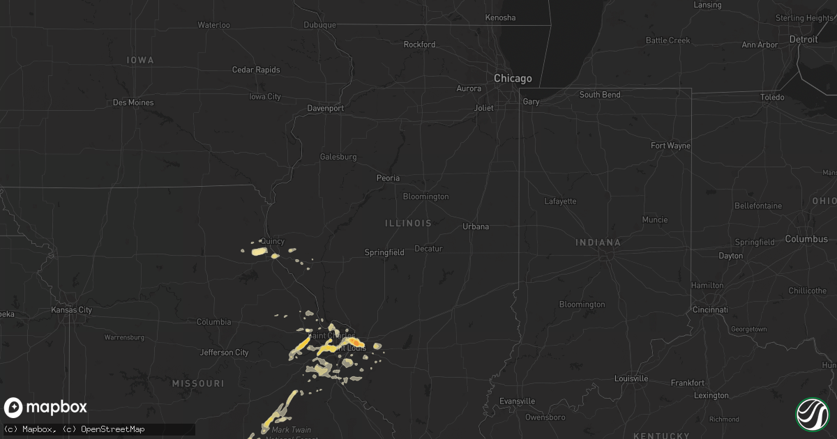
Hail Map in Illinois on April 30, 2016
Get this storm
April 30 map
$229
one time, instant access
Download today. No call, no setup
Keep the $229
Bought the map and want the full workflow? Apply the entire $229 to a subscription within 7 days. None of it is wasted.
Every map, not just this one
This buys you this map. Subscription and you get every map we run, in the markets you choose from a few cities to whole states to nationwide. Plus real-time alerts the moment a storm fires.
Contact data
Name, contact info, occupancy, even credit band for addresses in the footprint. You go from where it hit to who to call.
Become the source they trust
Unlimited branding weather history reports on demand. You already have the documented answer ready for the property owner, and you are the one who showed up with it.
Property data and RoofTrace estimates
Pull up any address you have got, its value and the exact code rules for that jurisdiction, straight from One Click Code. Then RoofTrace estimates the squares, pitch, and roof value, priced the way you price.
Storm reports in Illinois
Illinois
| Date | Description |
|---|---|
| 04/30/20165:42 PM CDT | A local report indicates 1.00 inch wind near 2 S RICHFIELD |
| 04/30/20165:25 PM CDT | A local report indicates 1.00 inch wind near PAYSON |
| 04/29/20168:04 PM CDT | A local report indicates 1.00 inch wind near CASEYVILLE |
| 04/29/20168:02 PM CDT | Social media report |
| 04/29/20168:01 PM CDT | A local report indicates 1.00 inch wind near COLLINSVILLE |
| 04/29/20167:53 PM CDT | A local report indicates 1.75 inch wind near 5 SE GRANITE CITY |
| 04/29/20167:53 PM CDT | Near the intersection of il routes 162 and 111. Covering the ground. |
| 04/29/20167:49 PM CDT | A local report indicates 1.75 inch wind near 1 SW PONTOON BEACH |
| 04/29/20167:48 PM CDT | A local report indicates 1.00 inch wind near GRANITE CITY |
| 04/29/20167:43 PM CDT | A local report indicates 1.00 inch wind near GRANITE CITY |
| 04/29/20167:40 PM CDT | A local report indicates 1.00 inch wind near GRANITE CITY |
All States Impacted by Hail Map on April 30, 2016
Cities Impacted by Hail Map on April 30, 2016
- Cameron, LA
- Lacassine, LA
- Iowa, LA
- Lake Charles, LA
- Bell City, LA
- Lonedell, MO
- Chesterfield, MO
- Luthersville, GA
- Potosi, MO
- Sullivan, MO
- Jeanerette, LA
- New Iberia, LA
- Baldwin, LA
- Franklin, LA
- Erath, LA
- Gainesville, MO
- Sulphur, LA
- Orange, TX
- Westlake, LA
- Dequincy, LA
- Vinton, LA
- Starks, LA
- Mountain Home, AR
- Oakland, AR
- Tecumseh, MO
- Calico Rock, AR
- Elizabeth, AR
- Raymondville, MO
- Licking, MO
- Houston, MO
- Hannibal, MO
- Hull, IL
- Saint Joe, AR
- Everton, AR
- Solo, MO
- Elk Creek, MO
- Atlanta, GA
- Port Arthur, TX
- Sabine Pass, TX
- Marshall, AR
- Mount Judea, AR
- Ash Flat, AR
- Carencro, LA
- Rayne, LA
- Church Point, LA
- Duson, LA
- Lafayette, LA
- Sunset, LA
- Scott, LA
- Vanzant, MO
- Gassville, AR
- Dolph, AR
- Wideman, AR
- Washington, MO
- Louin, MS
- Arnaudville, LA
- Breaux Bridge, LA
- Trenton, IL
- Saint Jacob, IL
- Lebanon, IL
- Chatsworth, GA
- Crandall, GA
- Emden, MO
- Shelbyville, MO
- Grand Chenier, LA
- Welsh, LA
- Hackberry, LA
- Willow Springs, MO
- Brussels, IL
- Bourbon, MO
- Wentzville, MO
- Glenwood, AR
- Amity, AR
- Kirby, AR
- Collinsville, IL
- Caseyville, IL
- East Saint Louis, IL
- Saint Louis, MO
- Granite City, IL
- Madison, IL
- Marthasville, MO
- Augusta, MO
- Hardy, AR
- Delcambre, LA
- Horseshoe Bend, AR
- Valley Springs, AR
- Mascoutah, IL
- New Baden, IL
- Franklin, AR
- Sage, AR
- Evening Shade, AR
- Foristell, MO
- Wright City, MO
- Kaplan, LA
- Yukon, MO
- Salem, MO
- Atkins, AR
- Beaumont, TX
- Refugio, TX
- Cabool, MO
- Eunice, MO
- Brockwell, AR
- Ravenden Springs, AR
- Poughkeepsie, AR
- Summit, AR
- Clarkridge, AR
- Melbourne, AR
- Midway, AR
- Ravenden, AR
- Pindall, AR
- Oxford, AR
- Witts Springs, AR
- Pelsor, AR
- Dover, AR
- Wiseman, AR
- Pineville, AR
- Cherokee Village, AR
- Williford, AR
- Norfork, AR
- Cotter, AR
- Bexar, AR
- Hagarville, AR
- Yellville, AR
- Pocahontas, AR
- Violet Hill, AR
- Flippin, AR
- Imboden, AR
- Salem, AR
- Black Rock, AR
- Millstadt, IL
- Columbia, IL
- O'Fallon, IL
- Saint Albans, MO
- Defiance, MO
- Ballwin, MO
- Venice, IL
- Maryland Heights, MO
- Pacific, MO
- Wildwood, MO
- Strawberry, AR
- Saffell, AR
- Sulphur Rock, AR
- Summersville, MO
- Zanoni, MO
- Brixey, MO
- Dora, MO
- Palmyra, MO
- Grubville, MO
- Dittmer, MO
- Robertsville, MO
- Saint Charles, MO
- Opelousas, LA
- Steelville, MO
- Davisville, MO
- Cherryville, MO
- Wesco, MO
- Cook Sta, MO
- Florissant, MO
- Hazelwood, MO
- Cadet, MO
- Blackwell, MO
- Waterloo, IL
- Fults, IL
- Valmeyer, IL
- Alicia, AR
- Belleville, IL
- Marshville, NC
- O'Fallon, MO
- Gurdon, AR
- Arkadelphia, AR
- Gilbertown, AL
- Silas, AL
- Moreland, GA
- Pittsfield, IL
- Dupo, IL
- East Carondelet, IL
- Arnold, MO
- Suches, GA
- Winfield, MO
- Rock Hill, SC
- Fort Mill, SC
- Lancaster, SC
- Catawba, SC
- New Athens, IL
- Smithton, IL
- Senoia, GA
- Durham, MO
- Maywood, MO
- Ewing, MO
- Hillsboro, MO
- Magnolia, TX
- Pinehurst, TX
- Liberty, IL
- Plainville, IL
- Victoria, TX
- Russellville, AR
- Hattieville, AR
- Solgohachia, AR
- Morrilton, AR
- Pottsville, AR
- Singer, LA
- Jennings, LA
- Port Neches, TX
- Lafayette, TN
- Red Boiling Springs, TN
- Saint Martinville, LA
- Crowley, LA
- Philadelphia, MO
- Kinder, LA
- Oberlin, LA
- House Springs, MO
- Tivoli, TX
- Highland, IL
- Roanoke, LA
- Red Bud, IL
- Imperial, MO
- Barnhart, MO
- Hawk Point, MO
- Truxton, MO
- Walnut Ridge, AR
- Bull Shoals, AR
- Mountain Grove, MO
- Hardenville, MO
- Waller, TX
- Hempstead, TX
- Edgemoor, SC
- Barry, IL
- Troy, MO
- Eureka, MO
- Caulfield, MO
- Monroe City, MO
- Bellflower, MO
- Batesville, AR
- Cave City, AR
- Caddo Gap, AR
- Creole, LA
- Grosse Tete, LA
- Maurice, LA
- Springfield, AR
- New Haven, MO
- Lake Saint Louis, MO
- Leslie, MO
- Bridgeton, MO
- Portage Des Sioux, MO
- Conroe, TX
- Foley, MO
- West Alton, MO
- Mora, LA
- Flatwoods, LA
- Lena, LA
- Provencal, LA
- Leesville, LA
- Saint Clair, MO
- High Ridge, MO
- Cedar Hill, MO
- Catawissa, MO
- Newnan, GA
- Cord, AR
- Mittie, LA
- Humble, TX
- Dry Creek, LA
- West Plains, MO
- Eunice, LA
- Iota, LA
- Branch, LA
- Spring, TX
- Tomball, TX
- Lamar, AR
- Gamaliel, AR
- De Soto, MO
- Richwoods, MO
- Hector, AR
- Mount Hope, AL
- Russellville, AL
- Town Creek, AL
- Jamestown, KY
- Elsberry, MO
- Bismarck, AR
- Griggsville, IL
- Simmesport, LA
- Plaucheville, LA
- Morrow, LA
- Signal Mountain, TN
- Whitwell, TN
- Chattanooga, TN
- Nederland, TX
- Pevely, MO
- Festus, MO
- Herculaneum, MO
- Germantown, IL
- Montgomery, TX
- Texarkana, AR
- Maringouin, LA
- Morse, LA
- Port Barre, LA
- Estherwood, LA
- Broussard, LA
- Youngsville, LA
- Taylor, MO
- Lake Arthur, LA
- Pleasant Hill, LA
- Hope, AR
- Crosby, TX
- Freeburg, IL
- Viburnum, MO
- Porter, TX
- Waxhaw, NC
- Deridder, LA
- Dardanelle, AR
- Lakeview, AR
- Pontiac, MO
- Pendleton, SC
- Anderson, SC
- Evensville, TN
- Dayton, TN
- Soddy Daisy, TN
- Dunlap, TN
- Sharon, SC
- Chester, SC
- York, SC
- McConnells, SC
- Sparkman, AR
- Payson, IL
- Quincy, IL
- Troy, IL
- Maryville, IL


