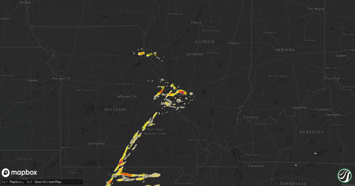
Hail Map on April 30, 2016
Get this storm
April 30 map
$229
one time, instant access
Download today. No call, no setup
Keep the $229
Bought the map and want the full workflow? Apply the entire $229 to a subscription within 7 days. None of it is wasted.
Every map, not just this one
This buys you this map. Subscription and you get every map we run, in the markets you choose from a few cities to whole states to nationwide. Plus real-time alerts the moment a storm fires.
Contact data
Name, contact info, occupancy, even credit band for addresses in the footprint. You go from where it hit to who to call.
Become the source they trust
Unlimited branding weather history reports on demand. You already have the documented answer ready for the property owner, and you are the one who showed up with it.
Property data and RoofTrace estimates
Pull up any address you have got, its value and the exact code rules for that jurisdiction, straight from One Click Code. Then RoofTrace estimates the squares, pitch, and roof value, priced the way you price.
States Impacted by Hail Map on April 30, 2016
Storm reports
Illinois
| Date | Description |
|---|---|
| 04/30/20165:42 PM CDT | A local report indicates 1.00 inch wind near 2 S RICHFIELD |
| 04/30/20165:25 PM CDT | A local report indicates 1.00 inch wind near PAYSON |
| 04/29/20168:04 PM CDT | A local report indicates 1.00 inch wind near CASEYVILLE |
| 04/29/20168:02 PM CDT | Social media report |
| 04/29/20168:01 PM CDT | A local report indicates 1.00 inch wind near COLLINSVILLE |
| 04/29/20167:53 PM CDT | A local report indicates 1.75 inch wind near 5 SE GRANITE CITY |
| 04/29/20167:53 PM CDT | Near the intersection of il routes 162 and 111. Covering the ground. |
| 04/29/20167:49 PM CDT | A local report indicates 1.75 inch wind near 1 SW PONTOON BEACH |
| 04/29/20167:48 PM CDT | A local report indicates 1.00 inch wind near GRANITE CITY |
| 04/29/20167:43 PM CDT | A local report indicates 1.00 inch wind near GRANITE CITY |
| 04/29/20167:40 PM CDT | A local report indicates 1.00 inch wind near GRANITE CITY |
Tennessee
| Date | Description |
|---|---|
| 04/30/20164:15 PM CDT | Multiple trees down in powells crossroad...mainly along richards lane |
Missouri
| Date | Description |
|---|---|
| 04/30/20166:58 PM CDT | A local report indicates 1.50 inch wind near 2 W PALMYRA |
| 04/30/20166:55 PM CDT | A local report indicates 1.00 inch wind near 2 W PALMYRA |
| 04/30/20166:55 PM CDT | 1.25 inch hail estimated using a photo via facebook. |
| 04/30/20166:47 PM CDT | A local report indicates 1.00 inch wind near MANCHESTER |
| 04/30/20166:43 PM CDT | A local report indicates 1.00 inch wind near TOWN AND COUNTRY |
| 04/30/20166:42 PM CDT | A local report indicates 1.50 inch wind near CHESTERFIELD |
| 04/30/20166:40 PM CDT | A local report indicates 1.00 inch wind near MANCHESTER |
| 04/30/20166:34 PM CDT | From 2 inch to 1.5 inch hail. Size estimated from photo. |
| 04/30/20165:55 PM CDT | Dime to quarter sized hail. |
| 04/29/20168:20 PM CDT | Quarter size hail via social media post 5.3 miles north of salem on highway 19. Time estimated by radar |
| 04/29/20168:20 PM CDT | A local report indicates 1.00 inch wind near 2 SSW IMPERIAL |
| 04/29/20168:00 PM CDT | Several social media photos of quarter to half dollar size hail in cabool at 8pm |
| 04/29/20167:40 PM CDT | Estimate based on photo. 1.25 inch hail. |
| 04/29/20167:32 PM CDT | Dime to quarter size hail on highway 181 at the douglas and howell county line |
| 04/29/20167:30 PM CDT | Nickel to quarter size hail at montauk state park. Corrected for size. |
| 04/29/20167:21 PM CDT | Near interstate 40 70 intesection. Lasted close to 5 minutes |
| 04/29/20167:15 PM CDT | A local report indicates 1.00 inch wind near FLORISSANT |
| 04/29/20167:11 PM CDT | A local report indicates 1.00 inch wind near UNIVERSITY CITY |
| 04/29/20167:07 PM CDT | Pea to golfball sized hail |
| 04/29/20167:05 PM CDT | Delayed report |
| 04/29/20167:00 PM CDT | A local report indicates 1.00 inch wind near 1 N PALMYRA |
Georgia
| Date | Description |
|---|---|
| 04/30/20166:21 PM CDT | 911 center received report of multiple trees down near the intersection of moore road and gordon road |
| 04/30/20166:15 PM CDT | 911 call center received report of multiple trees down in sugar valley...particularly on old rome dalton road. |
| 04/30/20165:45 PM CDT | Numerous trees and powerlines reported down by atlanta fire at intersection of w. Wesley rd and moores mill rd. |
| 04/30/20165:42 PM CDT | Few trees and power lines down. Measured gust to 44 mph at kvld. |
| 04/30/20165:35 PM CDT | A tree was blown onto a house at 125 laurel avenue sw. |
Mississippi
| Date | Description |
|---|---|
| 04/30/20164:05 PM CDT | Large tree down |
| 04/30/20164:05 PM CDT | Large tree down |
| 04/30/20162:00 PM CDT | One tree took down a power line on natchez avenue |
| 04/30/20161:55 PM CDT | One tree down on highway 550 |
Alabama
| Date | Description |
|---|---|
| 04/30/20166:45 PM CDT | One tree reported down. Winds were driven by a possible wake low. Location was estimated. |
| 04/30/20165:00 PM CDT | 50-60 mph winds estimated in ardmore. |
Louisiana
| Date | Description |
|---|---|
| 04/30/20162:02 PM CDT | Public report via social media of 60 mph wind gust 1 mile north of i-12 at highway 447. |
| 04/30/20161:54 PM CDT | Tree fell on a house at 24605 walker south road. Time estimated from radar. |
| 04/30/20161:52 PM CDT | Large tree down on wax road southeast of denham springs. Radar estimated the time of the event. |
| 04/30/20161:43 PM CDT | Pictures of tree limbs down near naomi harris road and wax road via social media. Time estimated from radar. |
| 04/30/201612:35 PM CDT | New roads false river regional airport reported a wind gust of 58mph. |
| 04/30/201610:55 AM CDT | Report of large oak tree down on george rd. |
| 04/30/20166:00 AM CDT | Public reported quarter size hail in breaux bridge |
| 04/30/20164:15 AM CDT | Public posted video of ping pong ball size hail in vatican. |
| 04/30/20164:00 AM CDT | Report of golf ball size hail on lacassine road in lafayette parish. |
Arkansas
| Date | Description |
|---|---|
| 04/30/20166:55 PM CDT | A local report indicates 1.25 inch wind near ATKINS |
| 04/30/20166:20 PM CDT | At jordan marina...quarter sized hail covering the ground with numerous golf ball size hail stones observed as well. |
| 04/30/20166:10 PM CDT | A local report indicates 1.75 inch wind near 1 N BRIARCLIFF |
| 04/30/20166:10 PM CDT | A local report indicates 1.00 inch wind near 8 ESE MOUNTAIN HOME |
| 04/30/20166:00 PM CDT | A local report indicates 1.00 inch wind near 3 S MOUNTAIN HOME |
| 04/30/20165:45 PM CDT | A local report indicates 1.00 inch wind near 1 N GASSVILLE |
| 04/30/20165:45 PM CDT | A local report indicates 1.00 inch wind near MT NEBO SP |
| 04/30/20161:40 AM CDT | First responder reported quarter size hail in amity. |
| 04/29/20169:30 PM CDT | A local report indicates 1.00 inch wind near ASH FLAT |
| 04/29/20169:24 PM CDT | A local report indicates 1.00 inch wind near 2 NW EVENING SHADE |
| 04/29/20169:15 PM CDT | A local report indicates 1.00 inch wind near CHEROKEE VILLAGE |
| 04/29/20169:10 PM CDT | Hail from dime to golfball size covered the ground. |
| 04/29/20169:08 PM CDT | A local report indicates 64 MPH wind near 3 NNE MOUNTAIN HOME |
| 04/29/20169:08 PM CDT | Many limbs were blown down...and two trees were uprooted. |
| 04/29/20168:08 PM CDT | Relayed by nws sgringfield. |
| 04/29/20167:30 PM CDT | Tree limbs broken from thunderstorm winds. |
Texas
| Date | Description |
|---|---|
| 04/30/20169:02 AM CDT | Jasper county sheriff has received several reports of damage to trees and powerlines in call. Possible tornado. |
| 04/30/20167:52 AM CDT | Tree down on dawnwood drive. |
| 04/30/20167:37 AM CDT | Tree down on rose road. |
| 04/30/20167:36 AM CDT | Tree down on boothill and old coach road. |
Cities Impacted by Hail Map on April 30, 2016
- Cameron, LA
- Lacassine, LA
- Iowa, LA
- Lake Charles, LA
- Bell City, LA
- Lonedell, MO
- Chesterfield, MO
- Luthersville, GA
- Potosi, MO
- Sullivan, MO
- Jeanerette, LA
- New Iberia, LA
- Baldwin, LA
- Franklin, LA
- Erath, LA
- Gainesville, MO
- Sulphur, LA
- Orange, TX
- Westlake, LA
- Dequincy, LA
- Vinton, LA
- Starks, LA
- Mountain Home, AR
- Oakland, AR
- Tecumseh, MO
- Calico Rock, AR
- Elizabeth, AR
- Raymondville, MO
- Licking, MO
- Houston, MO
- Hannibal, MO
- Hull, IL
- Saint Joe, AR
- Everton, AR
- Solo, MO
- Elk Creek, MO
- Atlanta, GA
- Port Arthur, TX
- Sabine Pass, TX
- Marshall, AR
- Mount Judea, AR
- Ash Flat, AR
- Carencro, LA
- Rayne, LA
- Church Point, LA
- Duson, LA
- Lafayette, LA
- Sunset, LA
- Scott, LA
- Vanzant, MO
- Gassville, AR
- Dolph, AR
- Wideman, AR
- Washington, MO
- Louin, MS
- Arnaudville, LA
- Breaux Bridge, LA
- Trenton, IL
- Saint Jacob, IL
- Lebanon, IL
- Chatsworth, GA
- Crandall, GA
- Emden, MO
- Shelbyville, MO
- Grand Chenier, LA
- Welsh, LA
- Hackberry, LA
- Willow Springs, MO
- Brussels, IL
- Bourbon, MO
- Wentzville, MO
- Glenwood, AR
- Amity, AR
- Kirby, AR
- Collinsville, IL
- Caseyville, IL
- East Saint Louis, IL
- Saint Louis, MO
- Granite City, IL
- Madison, IL
- Marthasville, MO
- Augusta, MO
- Hardy, AR
- Delcambre, LA
- Horseshoe Bend, AR
- Valley Springs, AR
- Mascoutah, IL
- New Baden, IL
- Franklin, AR
- Sage, AR
- Evening Shade, AR
- Foristell, MO
- Wright City, MO
- Kaplan, LA
- Yukon, MO
- Salem, MO
- Atkins, AR
- Beaumont, TX
- Refugio, TX
- Cabool, MO
- Eunice, MO
- Brockwell, AR
- Ravenden Springs, AR
- Poughkeepsie, AR
- Summit, AR
- Clarkridge, AR
- Melbourne, AR
- Midway, AR
- Ravenden, AR
- Pindall, AR
- Oxford, AR
- Witts Springs, AR
- Pelsor, AR
- Dover, AR
- Wiseman, AR
- Pineville, AR
- Cherokee Village, AR
- Williford, AR
- Norfork, AR
- Cotter, AR
- Bexar, AR
- Hagarville, AR
- Yellville, AR
- Pocahontas, AR
- Violet Hill, AR
- Flippin, AR
- Imboden, AR
- Salem, AR
- Black Rock, AR
- Millstadt, IL
- Columbia, IL
- O'Fallon, IL
- Saint Albans, MO
- Defiance, MO
- Ballwin, MO
- Venice, IL
- Maryland Heights, MO
- Pacific, MO
- Wildwood, MO
- Strawberry, AR
- Saffell, AR
- Sulphur Rock, AR
- Summersville, MO
- Zanoni, MO
- Brixey, MO
- Dora, MO
- Palmyra, MO
- Grubville, MO
- Dittmer, MO
- Robertsville, MO
- Saint Charles, MO
- Opelousas, LA
- Steelville, MO
- Davisville, MO
- Cherryville, MO
- Wesco, MO
- Cook Sta, MO
- Florissant, MO
- Hazelwood, MO
- Cadet, MO
- Blackwell, MO
- Waterloo, IL
- Fults, IL
- Valmeyer, IL
- Alicia, AR
- Belleville, IL
- Marshville, NC
- O'Fallon, MO
- Gurdon, AR
- Arkadelphia, AR
- Gilbertown, AL
- Silas, AL
- Moreland, GA
- Pittsfield, IL
- Dupo, IL
- East Carondelet, IL
- Arnold, MO
- Suches, GA
- Winfield, MO
- Rock Hill, SC
- Fort Mill, SC
- Lancaster, SC
- Catawba, SC
- New Athens, IL
- Smithton, IL
- Senoia, GA
- Durham, MO
- Maywood, MO
- Ewing, MO
- Hillsboro, MO
- Magnolia, TX
- Pinehurst, TX
- Liberty, IL
- Plainville, IL
- Victoria, TX
- Russellville, AR
- Hattieville, AR
- Solgohachia, AR
- Morrilton, AR
- Pottsville, AR
- Singer, LA
- Jennings, LA
- Port Neches, TX
- Lafayette, TN
- Red Boiling Springs, TN
- Saint Martinville, LA
- Crowley, LA
- Philadelphia, MO
- Kinder, LA
- Oberlin, LA
- House Springs, MO
- Tivoli, TX
- Highland, IL
- Roanoke, LA
- Red Bud, IL
- Imperial, MO
- Barnhart, MO
- Hawk Point, MO
- Truxton, MO
- Walnut Ridge, AR
- Bull Shoals, AR
- Mountain Grove, MO
- Hardenville, MO
- Waller, TX
- Hempstead, TX
- Edgemoor, SC
- Barry, IL
- Troy, MO
- Eureka, MO
- Caulfield, MO
- Monroe City, MO
- Bellflower, MO
- Batesville, AR
- Cave City, AR
- Caddo Gap, AR
- Creole, LA
- Grosse Tete, LA
- Maurice, LA
- Springfield, AR
- New Haven, MO
- Lake Saint Louis, MO
- Leslie, MO
- Bridgeton, MO
- Portage Des Sioux, MO
- Conroe, TX
- Foley, MO
- West Alton, MO
- Mora, LA
- Flatwoods, LA
- Lena, LA
- Provencal, LA
- Leesville, LA
- Saint Clair, MO
- High Ridge, MO
- Cedar Hill, MO
- Catawissa, MO
- Newnan, GA
- Cord, AR
- Mittie, LA
- Humble, TX
- Dry Creek, LA
- West Plains, MO
- Eunice, LA
- Iota, LA
- Branch, LA
- Spring, TX
- Tomball, TX
- Lamar, AR
- Gamaliel, AR
- De Soto, MO
- Richwoods, MO
- Hector, AR
- Mount Hope, AL
- Russellville, AL
- Town Creek, AL
- Jamestown, KY
- Elsberry, MO
- Bismarck, AR
- Griggsville, IL
- Simmesport, LA
- Plaucheville, LA
- Morrow, LA
- Signal Mountain, TN
- Whitwell, TN
- Chattanooga, TN
- Nederland, TX
- Pevely, MO
- Festus, MO
- Herculaneum, MO
- Germantown, IL
- Montgomery, TX
- Texarkana, AR
- Maringouin, LA
- Morse, LA
- Port Barre, LA
- Estherwood, LA
- Broussard, LA
- Youngsville, LA
- Taylor, MO
- Lake Arthur, LA
- Pleasant Hill, LA
- Hope, AR
- Crosby, TX
- Freeburg, IL
- Viburnum, MO
- Porter, TX
- Waxhaw, NC
- Deridder, LA
- Dardanelle, AR
- Lakeview, AR
- Pontiac, MO
- Pendleton, SC
- Anderson, SC
- Evensville, TN
- Dayton, TN
- Soddy Daisy, TN
- Dunlap, TN
- Sharon, SC
- Chester, SC
- York, SC
- McConnells, SC
- Sparkman, AR
- Payson, IL
- Quincy, IL
- Troy, IL
- Maryville, IL