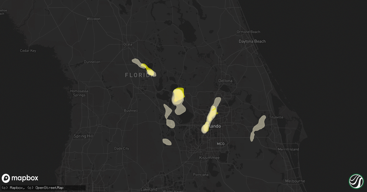
Hail Map in Mount Dora, FL on April 30, 2013
Get this storm
April 30 map
$229
one time, instant access
Download today. No call, no setup
Keep the $229
Bought the map and want the full workflow? Apply the entire $229 to a subscription within 7 days. None of it is wasted.
Every map, not just this one
This buys you this map. Subscription and you get every map we run, in the markets you choose from a few cities to whole states to nationwide. Plus real-time alerts the moment a storm fires.
Contact data
Name, contact info, occupancy, even credit band for addresses in the footprint. You go from where it hit to who to call.
Become the source they trust
Unlimited branding weather history reports on demand. You already have the documented answer ready for the property owner, and you are the one who showed up with it.
Property data and RoofTrace estimates
Pull up any address you have got, its value and the exact code rules for that jurisdiction, straight from One Click Code. Then RoofTrace estimates the squares, pitch, and roof value, priced the way you price.
Storm reports in Mount Dora, FL
Mount Dora, FL
| Date | Description |
|---|---|
| 04/30/20136:30 PM CDT | Nws ground survey indicated a northwest to southeast oriented line of straight line thunderstorm wind damage. Numerous oak trees and large limbs blown down. Estimated w |
| 04/30/20136:10 PM CDT | Skywarn spotter reported quarter size hail. |
| 04/30/20136:10 PM CDT | Skywarn spotter reported huge estimated 3 ft diameter oak tree blew down and damaged fence in yard. Dime size hail observed. |
| 04/30/201312:02 PM CDT | Nws ground survey indicated a northwest to southeast oriented line of straight line thunderstorm wind damage. Numerous oak trees and large limbs blown down. Estimated w |
All States Impacted by Hail Map on April 30, 2013
All Cities Impacted by Hail Map on April 30, 2013
- Waco, NE
- Christmas, FL
- Grand Portage, MN
- Aurora, NE
- Sherwood, MI
- Athens, MI
- Leonidas, MI
- Clermont, FL
- Orlando, FL
- Titusville, FL
- Silver Bay, MN
- North Bend, NE
- Dodge, NE
- Manning, IA
- Westside, IA
- Middleville, MI
- Hastings, MI
- Tye, TX
- Mount Dora, FL
- Tavares, FL
- Astatula, FL
- Wayland, MI
- Merkel, TX
- Eustis, FL
- Fort McCoy, FL
- Scribner, NE
- Lady Lake, FL
- Summerfield, FL
- Weirsdale, FL
- Longwood, FL
- Winter Park, FL
- Maitland, FL
- Casselberry, FL
- Altamonte Springs, FL
- West Point, NE
- Ochopee, FL
- Sand Lake, MI
- Axtell, NE
- Wewahitchka, FL
- Rogers, NE
- Fluvanna, TX
- Two Harbors, MN
- Okeechobee, FL
- York, NE
- Orient, IA
- Plainwell, MI
- Delton, MI
- Immokalee, FL
- Marshall, MI
- Olivet, MI
- Springport, MI
- Albion, MI
- Corning, IA
- Nodaway, IA
- Giltner, NE
- Hampton, NE
- Harvard, NE
- Creston, IA
- Prescott, IA
- Oakland, NE
- Stamford, NE
- Kalamazoo, MI
- Scotts, MI
- Phillipsburg, KS
- Galesburg, MI
- Hawthorne, FL
- Carbon, IA
- Villisca, IA
- Magnolia, TX
- Lake Mary, FL
- Coldwater, MI
- Orleans, NE
- Doniphan, NE
- Martin, MI
- Shelbyville, MI
- Hopkins, MI
- Otsego, MI
- Charlotte, MI
- Minden, NE
- Waller, TX
- Hockley, TX
- Farnhamville, IA
- Greenville, MI
- Colorado City, TX
- Bronson, MI
- Mattawan, MI
- Lawton, MI
- Rockford, MI
- Cedar Springs, MI
- Deerbrook, WI
- Ira, TX
- Coahoma, TX
- Eustis, NE
- Bellevue, MI
- Ocala, FL
- Belleview, FL
- Groveland, FL
- Howey In The Hills, FL
- Interlachen, FL
- Underwood, IA
- Earleton, FL
- Melrose, FL
- Union City, MI
- Henderson, NE
- Justiceburg, TX
- Lowell, MI
- Pierson, MI
- Floydada, TX
- Logan, KS
- Lohrville, IA
- Palisade, NE
- Sanford, FL
- Winter Springs, FL
- Fulton, MI
- Mendon, MI
- Richland, MI
- Hickory Corners, MI
- Arcadia, IA
- Carroll, IA
- Abilene, TX
- Kabetogama, MN
- Ocklawaha, FL


