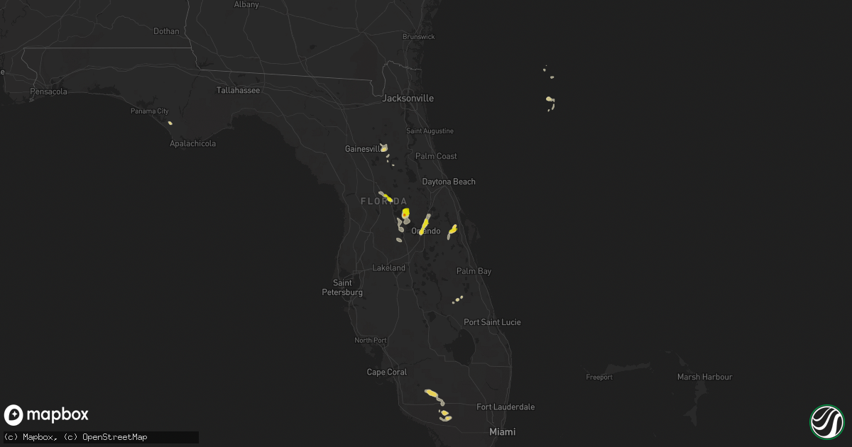
Hail Map on April 30, 2013
Get this storm
April 30 map
$229
one time, instant access
Download today. No call, no setup
Keep the $229
Bought the map and want the full workflow? Apply the entire $229 to a subscription within 7 days. None of it is wasted.
Every map, not just this one
This buys you this map. Subscription and you get every map we run, in the markets you choose from a few cities to whole states to nationwide. Plus real-time alerts the moment a storm fires.
Contact data
Name, contact info, occupancy, even credit band for addresses in the footprint. You go from where it hit to who to call.
Become the source they trust
Unlimited branding weather history reports on demand. You already have the documented answer ready for the property owner, and you are the one who showed up with it.
Property data and RoofTrace estimates
Pull up any address you have got, its value and the exact code rules for that jurisdiction, straight from One Click Code. Then RoofTrace estimates the squares, pitch, and roof value, priced the way you price.
States Impacted by Hail Map on April 30, 2013
Storm reports
Iowa
| Date | Description |
|---|---|
| 04/30/20136:58 PM CDT | Near the town of carl |
| 04/30/20136:56 PM CDT | Report forwarded by woi tv |
| 04/29/20137:15 PM CDT | A local report indicates 1.00 inch wind near 7 S GREENFIELD |
| 04/29/20137:05 PM CDT | Adams county em stated that there was a swath of 1 inch hail from lake icaria northeast to the county border. Hail fell from 635 pm cdt to 705 pm cdt. |
Minnesota
| Date | Description |
|---|---|
| 04/30/20137:35 AM CDT | A local report indicates 1.50 inch wind near SILVER BAY |
Florida
| Date | Description |
|---|---|
| 04/30/20136:30 PM CDT | Nws ground survey indicated a northwest to southeast oriented line of straight line thunderstorm wind damage. Numerous oak trees and large limbs blown down. Estimated w |
| 04/30/20136:20 PM CDT | Ham radio operator reported quarter size hail on central parkway behind altamonte mall. |
| 04/30/20136:20 PM CDT | Large oak tree fell on top of a home in winter park. Report obtained from wftv. |
| 04/30/20136:10 PM CDT | Skywarn spotter reported huge estimated 3 ft diameter oak tree blew down and damaged fence in yard. Dime size hail observed. |
| 04/30/20136:10 PM CDT | Skywarn spotter reported quarter size hail. |
| 04/30/20136:06 PM CDT | Quarter mile long path of pronounced damage to vegetation from sw to ne near christmas rv park in 25000 block of sr 50. 2 inch diameter palm fronds and pine branches do |
| 04/30/20131:30 PM CDT | A tree was down on the 400 block of vittorio partially blocking the road |
| 04/30/201312:02 PM CDT | Nws ground survey indicated a northwest to southeast oriented line of straight line thunderstorm wind damage. Numerous oak trees and large limbs blown down. Estimated w |
Texas
| Date | Description |
|---|---|
| 04/30/20135:45 PM CDT | Power poles snapped 1.5 miles east of west point. Time estimated. |
| 04/30/20135:38 PM CDT | 3.5 inch diameter tree limb snapped. |
| 04/30/20135:27 PM CDT | Power poles down at 50th st and mlk blvd |
| 04/30/20135:27 PM CDT | Power poles down at 50th st and mlk blvd |
| 04/30/20135:13 PM CDT | Measured at the kcbd-tv studio |
| 04/29/20139:50 PM CDT | Numerous trees knocked down on top of cars. Utility poles were also knocked down. |
Cities Impacted by Hail Map on April 30, 2013
- Waco, NE
- Christmas, FL
- Grand Portage, MN
- Aurora, NE
- Sherwood, MI
- Athens, MI
- Leonidas, MI
- Clermont, FL
- Orlando, FL
- Titusville, FL
- Silver Bay, MN
- North Bend, NE
- Dodge, NE
- Manning, IA
- Westside, IA
- Middleville, MI
- Hastings, MI
- Tye, TX
- Mount Dora, FL
- Tavares, FL
- Astatula, FL
- Wayland, MI
- Merkel, TX
- Eustis, FL
- Fort McCoy, FL
- Scribner, NE
- Lady Lake, FL
- Summerfield, FL
- Weirsdale, FL
- Longwood, FL
- Winter Park, FL
- Maitland, FL
- Casselberry, FL
- Altamonte Springs, FL
- West Point, NE
- Ochopee, FL
- Sand Lake, MI
- Axtell, NE
- Wewahitchka, FL
- Rogers, NE
- Fluvanna, TX
- Two Harbors, MN
- Okeechobee, FL
- York, NE
- Orient, IA
- Plainwell, MI
- Delton, MI
- Immokalee, FL
- Marshall, MI
- Olivet, MI
- Springport, MI
- Albion, MI
- Corning, IA
- Nodaway, IA
- Giltner, NE
- Hampton, NE
- Harvard, NE
- Creston, IA
- Prescott, IA
- Oakland, NE
- Stamford, NE
- Kalamazoo, MI
- Scotts, MI
- Phillipsburg, KS
- Galesburg, MI
- Hawthorne, FL
- Carbon, IA
- Villisca, IA
- Magnolia, TX
- Lake Mary, FL
- Coldwater, MI
- Orleans, NE
- Doniphan, NE
- Martin, MI
- Shelbyville, MI
- Hopkins, MI
- Otsego, MI
- Charlotte, MI
- Minden, NE
- Waller, TX
- Hockley, TX
- Farnhamville, IA
- Greenville, MI
- Colorado City, TX
- Bronson, MI
- Mattawan, MI
- Lawton, MI
- Rockford, MI
- Cedar Springs, MI
- Deerbrook, WI
- Ira, TX
- Coahoma, TX
- Eustis, NE
- Bellevue, MI
- Ocala, FL
- Belleview, FL
- Groveland, FL
- Howey In The Hills, FL
- Interlachen, FL
- Underwood, IA
- Earleton, FL
- Melrose, FL
- Union City, MI
- Henderson, NE
- Justiceburg, TX
- Lowell, MI
- Pierson, MI
- Floydada, TX
- Logan, KS
- Lohrville, IA
- Palisade, NE
- Sanford, FL
- Winter Springs, FL
- Fulton, MI
- Mendon, MI
- Richland, MI
- Hickory Corners, MI
- Arcadia, IA
- Carroll, IA
- Abilene, TX
- Kabetogama, MN
- Ocklawaha, FL