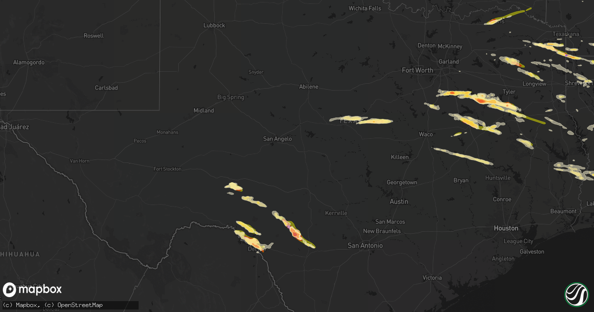
Hail Map in Texas on April 29, 2026
Get this storm
April 29 map
$229
one time, instant access
Download today. No call, no setup
Keep the $229
Bought the map and want the full workflow? Apply the entire $229 to a subscription within 7 days. None of it is wasted.
Every map, not just this one
This buys you this map. Subscription and you get every map we run, in the markets you choose from a few cities to whole states to nationwide. Plus real-time alerts the moment a storm fires.
Contact data
Name, contact info, occupancy, even credit band for addresses in the footprint. You go from where it hit to who to call.
Become the source they trust
Unlimited branding weather history reports on demand. You already have the documented answer ready for the property owner, and you are the one who showed up with it.
Property data and RoofTrace estimates
Pull up any address you have got, its value and the exact code rules for that jurisdiction, straight from One Click Code. Then RoofTrace estimates the squares, pitch, and roof value, priced the way you price.
Storm reports in Texas
Texas
| Date | Description |
|---|---|
| 04/29/20266:52 PM CDT | Report from mping hen egg |
| 04/29/20266:51 PM CDT | Report from mping hen egg |
| 04/29/20266:39 PM CDT | Report from mping quarter |
| 04/29/20266:36 PM CDT | Report from mping quarter |
| 04/29/20266:25 PM CDT | Media partner shared report of ~1.25 inch hail in jacksonville... Tx. West of 69 off hwy 135. |
| 04/29/20264:54 PM CDT | Reports from broadcast media of quarter size to golf ball size hail around bullard. Quarter size hail was reported east of us 69 along fm 344. |
| 04/29/20264:52 PM CDT | 911 call center recived a report of a tree down on fm 699 near carthage. |
| 04/29/20264:40 PM CDT | Report from mping: golf ball |
| 04/29/20264:31 PM CDT | Report from mping: half dollar |
| 04/29/20264:28 PM CDT | Amateur radio reports quarter sized hail in new york texas. |
| 04/29/20264:23 PM CDT | Quarter sized hail reported by amateur radio 3 miles nw of larue. |
| 04/29/20264:10 PM CDT | Report from mping: golf ball |
| 04/29/20264:08 PM CDT | Social media photos and videos showed up to tennis ball size hail in parts of athens. |
| 04/29/20263:34 PM CDT | Social media video of hail ranging from quarters to golf balls falling in seven points. Time estimated by radar. |
| 04/29/20263:31 PM CDT | Amateur radio reported quarter size hail 3 miles sw of mabank. |
| 04/29/20263:27 PM CDT | Amateur radio reported quarter size hail 1 mi south of seven points. |
| 04/29/20263:06 PM CDT | Amateur radio reported mostly quarter size hail with some larger size up to ping-pong ball. |
| 04/29/20262:36 PM CDT | Emergency manager reported 1.5 inch hail at the ennis public safety facility. |
| 04/29/20262:34 PM CDT | Social media photo on x showed 2.5 inch hail in ennis. |
| 04/29/20262:05 PM CDT | Reports of quarter size hail in judson. |
| 04/29/20262:05 PM CDT | Reports of half dollar to ping pong size hail just north of judson. |
| 04/29/20261:07 PM CDT | Social media report of approx. Ping pong ball sized hail in marietta. |
| 04/29/202612:08 PM CDT | Social media report of approx. Quarter sized hail in winnsboro. |
| 04/29/202611:16 AM CDT | Social media report of golf ball sized hail in douglassville. |
| 04/29/202610:56 AM CDT | Corrects previous hail report from marietta. Social media report of approx. Ping pong ball sized hail in marietta. |
| 04/28/202610:44 PM CDT | Media partner shared report of quarter-size hailstones along hwy 103 w in west lufkin. |
| 04/28/202610:23 PM CDT | Via facebook. |
| 04/28/202610:21 PM CDT | Report of numerous hail stones size of golf balls via phone call to the office. |
| 04/28/202610:00 PM CDT | Public report of hail to golf ball size off spur 406 on the north side of lake amistad. |
| 04/28/20269:25 PM CDT | Report from mping: half dollar |
| 04/28/20268:57 PM CDT | A local report indicates 1.00 inch wind near 2 SW Midway |
| 04/28/20268:55 PM CDT | Numerous reports of pea to golf ball size hail on the east side of fairfield. |
| 04/28/20268:50 PM CDT | Golf ball size hail reported at 460 hwy 75 north. |
| 04/28/20268:10 PM CDT | A local report indicates 1.00 inch wind near 2 WSW Concan |
| 04/28/20267:55 PM CDT | Photo showed quarter to half dollar size hail fell on lcr 433 around 7 miles south of mexica. |
| 04/28/20267:28 PM CDT | Picture on x of baseball size hail. |
| 04/28/20267:22 PM CDT | Report from mping baseball++ |
| 04/28/20267:21 PM CDT | Report from mping tea cup |
| 04/28/20267:08 PM CDT | A local report indicates 2.75 inch wind near 3 S Camp Wood |
| 04/28/20267:08 PM CDT | Video received of 3 to 3.5 inch diameter measured hail. |
| 04/28/20267:03 PM CDT | Picture on x. Time estimated from radar. |
| 04/28/20267:01 PM CDT | Report from mping hen egg |
All States Impacted by Hail Map on April 29, 2026
Cities Impacted by Hail Map on April 29, 2026
- Philadelphia, MS
- Collinsville, MS
- De Kalb, MS
- Union, MS
- Chunky, MS
- Enterprise, MS
- Meridian, MS
- Talco, TX
- Bogata, TX
- Mount Pleasant, TX
- Naples, TX
- Cookville, TX
- Omaha, TX
- Douglassville, TX
- Marietta, TX
- Queen City, TX
- Atlanta, TX
- Texarkana, AR
- Doddridge, AR
- Garland City, AR
- Sulphur Springs, TX
- Brashear, TX
- Cumby, TX
- Rodessa, LA
- Ida, LA
- Lewisville, AR
- Bradley, AR
- Fouke, AR
- Pickton, TX
- Como, TX
- Stamps, AR
- Plain Dealing, LA
- Winnsboro, TX
- Scroggins, TX
- Taylor, AR
- Magnolia, AR
- Yantis, TX
- Quitman, TX
- Pittsburg, TX
- Gilmer, TX
- Leesburg, TX
- Brownwood, TX
- Santa Anna, TX
- Emerson, AR
- Ore City, TX
- Cotton Valley, LA
- Sarepta, LA
- Shongaloo, LA
- Haynesville, LA
- Brandon, MS
- Florence, MS
- Pearl, MS
- Bangs, TX
- Junction City, AR
- Minden, LA
- Early, TX
- May, TX
- Blanket, TX
- Avinger, TX
- Homer, LA
- Raymond, MS
- Utica, MS
- Edwards, MS
- Lone Star, TX
- Comanche, TX
- Summerfield, LA
- Bernice, LA
- Lillie, LA
- Lisbon, LA
- Bolton, MS
- Jefferson, TX
- Terry, MS
- Linden, TX
- Big Sandy, TX
- Pelahatchie, MS
- Morton, MS
- Dubach, LA
- Richland, MS
- Mendenhall, MS
- Byram, MS
- Quitman, MS
- Spearsville, LA
- Diana, TX
- Longview, TX
- Vivian, LA
- Farmerville, LA
- Marion, LA
- Jackson, MS
- Gustine, TX
- Oil City, LA
- Jonesboro, LA
- Choudrant, LA
- Hallsville, TX
- Waxahachie, TX
- Forreston, TX
- Carlton, TX
- Raleigh, MS
- Dublin, TX
- Downsville, LA
- Wisner, LA
- Mize, MS
- Braxton, MS
- Nashville, AR
- Murfreesboro, AR
- Terrell, TX
- Shreveport, LA
- Chatham, LA
- Sikes, LA
- Hico, TX
- West Monroe, LA
- Ennis, TX
- Bay Springs, MS
- Taylorsville, MS
- Bossier City, LA
- Benton, LA
- Calhoun, LA
- Louin, MS
- Hamilton, TX
- Forest, MS
- Forney, TX
- Mooringsport, LA
- Sicily Island, LA
- Harrisville, MS
- Pinola, MS
- Georgetown, MS
- Montgomery, WV
- Smithers, WV
- Grayson, LA
- Haughton, LA
- Princeton, LA
- Rice, TX
- Chatfield, TX
- Kemp, TX
- Saint Joseph, LA
- Clayton, LA
- Kimberly, WV
- Gauley Bridge, WV
- Mount Carbon, WV
- Kanawha Falls, WV
- Barksdale Afb, LA
- Magee, MS
- Columbia, LA
- Stringer, MS
- Port Gibson, MS
- Prentiss, MS
- Mount Olive, MS
- Laurel, MS
- Newhebron, MS
- Lorman, MS
- Monroe, LA
- Heidelberg, MS
- Collins, MS
- Mabank, TX
- Coffeeville, AL
- Ozona, TX
- Hazlehurst, MS
- Collinston, LA
- Trinidad, TX
- Eustace, TX
- Malakoff, TX
- Athens, TX
- Ovett, MS
- Shubuta, MS
- Clifton, TX
- Waynesboro, MS
- Petty, TX
- Roxton, TX
- Brookston, TX
- Paris, TX
- Sumner, TX
- Richton, MS
- Silver Creek, MS
- Oak Vale, MS
- Honey Grove, TX
- Klondike, TX
- Franklin, AL
- Larue, TX
- Frankston, TX
- Murchison, TX
- Brownsboro, TX
- Blossom, TX
- State Line, MS
- Buckatunna, MS
- De Berry, TX
- Scooba, MS
- Detroit, TX
- Bullard, TX
- Flint, TX
- Jacksonville, TX
- Carthage, TX
- Del Rio, TX
- Ruth, MS
- Jayess, MS
- Troup, TX
- Bagwell, TX
- Clarksville, TX
- Idabel, OK
- Grand Cane, LA
- Neely, MS
- Leakesville, MS
- Emelle, AL
- Garvin, OK
- Palestine, TX
- Rocksprings, TX
- Chandler, TX
- Mansfield, LA
- Lucedale, MS
- Barksdale, TX
- Marthaville, LA
- Camp Wood, TX
- Newton, TX
- Burkeville, TX
- Rusk, TX
- Many, LA
- Zwolle, LA
- Deridder, LA
- Merryville, LA
- Laneville, TX
- Henderson, TX
- Jasper, TX
- Natchez, LA
- Melrose, LA
- Reklaw, TX
- Colfax, LA
- Cloutierville, LA
- Uvalde, TX
- Bogalusa, LA
- Chilton, TX
- Marlin, TX
- Wiergate, TX
- Reform, AL
- Reagan, TX
- Bremond, TX
- Carriere, MS
- Picayune, MS
- Poplarville, MS
- Ethelsville, AL
- Hillsboro, TX
- Milford, TX
- Kosse, TX
- Franklin, TX
- Mertens, TX
- Gordo, AL
- Millport, AL
- Kennedy, AL
- Cushing, TX
- Frost, TX
- Itasca, TX
- Perkinston, MS
- Bay Saint Louis, MS
- Stoneville, NC
- Mayodan, NC
- Kiln, MS
- Nacogdoches, TX
- Garrison, TX
- Concan, TX
- Sabinal, TX
- Madison, NC
- Marquez, TX
- Normangee, TX
- Bynum, TX
- Comstock, TX
- Groesbeck, TX
- Knippa, TX
- Texarkana, TX
- Purdon, TX
- Dawson, TX
- Mexia, TX
- Berry, AL
- Northport, AL
- Franklinton, LA
- Reidsville, NC
- Wortham, TX
- Streetman, TX
- Fairfield, TX
- Midway, TX
- Madisonville, TX
- Quinton, AL
- Browns Summit, NC
- Gibsonville, NC
- Richland, TX
- Bessemer, AL
- Oakman, AL
- Oakwood, TX
- Elkhart, TX
- Mulga, AL
- Teague, TX
- Elon, NC
- Tennessee Colony, TX
- Adamsville, AL
- Mebane, NC
- Haw River, NC
- Graham, NC
- Midland, NC
- Concord, NC
- Locust, NC
- Chapel Hill, NC
- Timpson, TX
- Efland, NC
- Hillsborough, NC
- Oxford, NC
- Henderson, NC
- Burlington, NC
- Center, TX
- Grapeland, TX
- Colmesneil, TX
- Carrboro, NC
- Preston, MS
- Laughlin Afb, TX
- Kennard, TX
- Shelbyville, TX
- San Augustine, TX
- Alto, TX
- Kirbyville, TX
- Wells, TX
- Ansted, WV
- Lookout, WV
- Pollok, TX
- Lufkin, TX
- Milam, TX
- Bon Wier, TX
- Brackettville, TX
- Strong, AR
- Florien, LA
- Harleton, TX
- Elm Grove, LA
- Gary, TX
- Ehrhardt, SC
- Bamberg, SC
- Belmont, LA
- Jonesville, LA
- Robeline, LA
- North Charleston, SC
- Charleston, SC
- Hanahan, SC


