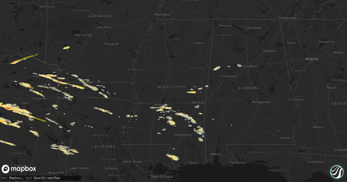
Hail Map in Mississippi on April 29, 2026
Get this storm
April 29 map
$229
one time, instant access
Download today. No call, no setup
Keep the $229
Bought the map and want the full workflow? Apply the entire $229 to a subscription within 7 days. None of it is wasted.
Every map, not just this one
This buys you this map. Subscription and you get every map we run, in the markets you choose from a few cities to whole states to nationwide. Plus real-time alerts the moment a storm fires.
Contact data
Name, contact info, occupancy, even credit band for addresses in the footprint. You go from where it hit to who to call.
Become the source they trust
Unlimited branding weather history reports on demand. You already have the documented answer ready for the property owner, and you are the one who showed up with it.
Property data and RoofTrace estimates
Pull up any address you have got, its value and the exact code rules for that jurisdiction, straight from One Click Code. Then RoofTrace estimates the squares, pitch, and roof value, priced the way you price.
Storm reports in Mississippi
Mississippi
| Date | Description |
|---|---|
| 04/29/20265:40 PM CDT | Pike county sheriffs office reported a couple of trees down. |
| 04/29/20265:00 PM CDT | Corrects previous tstm wnd dmg report from 1 sw mccomb. Corrects previous tstm wnd dmg report from 1 sw mccomb. Pike county sheriffs office reported a couple of trees d |
| 04/29/20265:00 PM CDT | Corrects previous tstm wnd dmg report from 1 sw mccomb. Pike county sheriffs office reported a couple of trees down. |
| 04/29/20264:42 PM CDT | Tree down across palestine road. |
| 04/29/20264:18 PM CDT | A few trees down in town and outside of town. |
| 04/29/20264:16 PM CDT | Trees down. |
| 04/29/20264:04 PM CDT | A few trees down in the nw part of the county. |
| 04/29/20263:28 PM CDT | Two trees down on red lick road. |
| 04/29/20263:16 PM CDT | Jones county eoc reports that a tree fell on a house located on bonner road. They also report multiple trees and powerlines down in the area northeast of sandersville. |
| 04/29/20263:15 PM CDT | Video of at least 60 mph gusts and parts of trees breaking off. |
| 04/29/20263:14 PM CDT | Tree across old colony road. |
| 04/29/20263:08 PM CDT | Multiple trees down at cr 31 and 317. Crews still cutting trees out of the road way. Possible tornado. |
| 04/29/20263:00 PM CDT | A couple trees down. |
| 04/29/20263:00 PM CDT | Multiple trees down on cr 23 near and along cr 8. Some trees off the road were snapped. Possible tornado. |
| 04/29/20262:47 PM CDT | A couple trees down around town. |
| 04/29/20262:40 PM CDT | Couple trees down around town. |
| 04/29/20262:05 PM CDT | A local report indicates 1.00 inch wind near 1 SSW Florence |
| 04/29/20262:02 PM CDT | Trees down near byrd road and w mt creek. |
| 04/29/20261:50 PM CDT | Tree blocking terry road. |
| 04/29/20261:50 PM CDT | Tree across hwy 11 near the co line. |
| 04/29/20261:45 PM CDT | Tree downed across ms hwy 481. |
| 04/29/20261:32 PM CDT | Tree down blocking roadway on newman rd near hwy 27. |
| 04/29/20261:29 PM CDT | Tree across the road. |
| 04/29/20261:23 PM CDT | Along oakley-palestine road. |
| 04/29/20268:20 AM CDT | Corrects previous hail report from damascus. Quarter to ping pong ball sized hail via social media and broadcast media. |
| 04/29/20267:20 AM CDT | Quarter to ping pong ball sized hail via social media and broadcast media. |
| 04/28/20267:32 PM CDT | Public reports golf ball sized hail near carriere... Ms. |
| 04/28/20267:32 PM CDT | Emergency management reports a tree down in roadway and powerline down near carriere... Ms in pearl river county. |
| 04/28/20267:30 PM CDT | Public report on social media of quarter-sized hail near carriere... Ms in pearl river county. |
All States Impacted by Hail Map on April 29, 2026
Cities Impacted by Hail Map on April 29, 2026
- Philadelphia, MS
- Collinsville, MS
- De Kalb, MS
- Union, MS
- Chunky, MS
- Enterprise, MS
- Meridian, MS
- Talco, TX
- Bogata, TX
- Mount Pleasant, TX
- Naples, TX
- Cookville, TX
- Omaha, TX
- Douglassville, TX
- Marietta, TX
- Queen City, TX
- Atlanta, TX
- Texarkana, AR
- Doddridge, AR
- Garland City, AR
- Sulphur Springs, TX
- Brashear, TX
- Cumby, TX
- Rodessa, LA
- Ida, LA
- Lewisville, AR
- Bradley, AR
- Fouke, AR
- Pickton, TX
- Como, TX
- Stamps, AR
- Plain Dealing, LA
- Winnsboro, TX
- Scroggins, TX
- Taylor, AR
- Magnolia, AR
- Yantis, TX
- Quitman, TX
- Pittsburg, TX
- Gilmer, TX
- Leesburg, TX
- Brownwood, TX
- Santa Anna, TX
- Emerson, AR
- Ore City, TX
- Cotton Valley, LA
- Sarepta, LA
- Shongaloo, LA
- Haynesville, LA
- Brandon, MS
- Florence, MS
- Pearl, MS
- Bangs, TX
- Junction City, AR
- Minden, LA
- Early, TX
- May, TX
- Blanket, TX
- Avinger, TX
- Homer, LA
- Raymond, MS
- Utica, MS
- Edwards, MS
- Lone Star, TX
- Comanche, TX
- Summerfield, LA
- Bernice, LA
- Lillie, LA
- Lisbon, LA
- Bolton, MS
- Jefferson, TX
- Terry, MS
- Linden, TX
- Big Sandy, TX
- Pelahatchie, MS
- Morton, MS
- Dubach, LA
- Richland, MS
- Mendenhall, MS
- Byram, MS
- Quitman, MS
- Spearsville, LA
- Diana, TX
- Longview, TX
- Vivian, LA
- Farmerville, LA
- Marion, LA
- Jackson, MS
- Gustine, TX
- Oil City, LA
- Jonesboro, LA
- Choudrant, LA
- Hallsville, TX
- Waxahachie, TX
- Forreston, TX
- Carlton, TX
- Raleigh, MS
- Dublin, TX
- Downsville, LA
- Wisner, LA
- Mize, MS
- Braxton, MS
- Nashville, AR
- Murfreesboro, AR
- Terrell, TX
- Shreveport, LA
- Chatham, LA
- Sikes, LA
- Hico, TX
- West Monroe, LA
- Ennis, TX
- Bay Springs, MS
- Taylorsville, MS
- Bossier City, LA
- Benton, LA
- Calhoun, LA
- Louin, MS
- Hamilton, TX
- Forest, MS
- Forney, TX
- Mooringsport, LA
- Sicily Island, LA
- Harrisville, MS
- Pinola, MS
- Georgetown, MS
- Montgomery, WV
- Smithers, WV
- Grayson, LA
- Haughton, LA
- Princeton, LA
- Rice, TX
- Chatfield, TX
- Kemp, TX
- Saint Joseph, LA
- Clayton, LA
- Kimberly, WV
- Gauley Bridge, WV
- Mount Carbon, WV
- Kanawha Falls, WV
- Barksdale Afb, LA
- Magee, MS
- Columbia, LA
- Stringer, MS
- Port Gibson, MS
- Prentiss, MS
- Mount Olive, MS
- Laurel, MS
- Newhebron, MS
- Lorman, MS
- Monroe, LA
- Heidelberg, MS
- Collins, MS
- Mabank, TX
- Coffeeville, AL
- Ozona, TX
- Hazlehurst, MS
- Collinston, LA
- Trinidad, TX
- Eustace, TX
- Malakoff, TX
- Athens, TX
- Ovett, MS
- Shubuta, MS
- Clifton, TX
- Waynesboro, MS
- Petty, TX
- Roxton, TX
- Brookston, TX
- Paris, TX
- Sumner, TX
- Richton, MS
- Silver Creek, MS
- Oak Vale, MS
- Honey Grove, TX
- Klondike, TX
- Franklin, AL
- Larue, TX
- Frankston, TX
- Murchison, TX
- Brownsboro, TX
- Blossom, TX
- State Line, MS
- Buckatunna, MS
- De Berry, TX
- Scooba, MS
- Detroit, TX
- Bullard, TX
- Flint, TX
- Jacksonville, TX
- Carthage, TX
- Del Rio, TX
- Ruth, MS
- Jayess, MS
- Troup, TX
- Bagwell, TX
- Clarksville, TX
- Idabel, OK
- Grand Cane, LA
- Neely, MS
- Leakesville, MS
- Emelle, AL
- Garvin, OK
- Palestine, TX
- Rocksprings, TX
- Chandler, TX
- Mansfield, LA
- Lucedale, MS
- Barksdale, TX
- Marthaville, LA
- Camp Wood, TX
- Newton, TX
- Burkeville, TX
- Rusk, TX
- Many, LA
- Zwolle, LA
- Deridder, LA
- Merryville, LA
- Laneville, TX
- Henderson, TX
- Jasper, TX
- Natchez, LA
- Melrose, LA
- Reklaw, TX
- Colfax, LA
- Cloutierville, LA
- Uvalde, TX
- Bogalusa, LA
- Chilton, TX
- Marlin, TX
- Wiergate, TX
- Reform, AL
- Reagan, TX
- Bremond, TX
- Carriere, MS
- Picayune, MS
- Poplarville, MS
- Ethelsville, AL
- Hillsboro, TX
- Milford, TX
- Kosse, TX
- Franklin, TX
- Mertens, TX
- Gordo, AL
- Millport, AL
- Kennedy, AL
- Cushing, TX
- Frost, TX
- Itasca, TX
- Perkinston, MS
- Bay Saint Louis, MS
- Stoneville, NC
- Mayodan, NC
- Kiln, MS
- Nacogdoches, TX
- Garrison, TX
- Concan, TX
- Sabinal, TX
- Madison, NC
- Marquez, TX
- Normangee, TX
- Bynum, TX
- Comstock, TX
- Groesbeck, TX
- Knippa, TX
- Texarkana, TX
- Purdon, TX
- Dawson, TX
- Mexia, TX
- Berry, AL
- Northport, AL
- Franklinton, LA
- Reidsville, NC
- Wortham, TX
- Streetman, TX
- Fairfield, TX
- Midway, TX
- Madisonville, TX
- Quinton, AL
- Browns Summit, NC
- Gibsonville, NC
- Richland, TX
- Bessemer, AL
- Oakman, AL
- Oakwood, TX
- Elkhart, TX
- Mulga, AL
- Teague, TX
- Elon, NC
- Tennessee Colony, TX
- Adamsville, AL
- Mebane, NC
- Haw River, NC
- Graham, NC
- Midland, NC
- Concord, NC
- Locust, NC
- Chapel Hill, NC
- Timpson, TX
- Efland, NC
- Hillsborough, NC
- Oxford, NC
- Henderson, NC
- Burlington, NC
- Center, TX
- Grapeland, TX
- Colmesneil, TX
- Carrboro, NC
- Preston, MS
- Laughlin Afb, TX
- Kennard, TX
- Shelbyville, TX
- San Augustine, TX
- Alto, TX
- Kirbyville, TX
- Wells, TX
- Ansted, WV
- Lookout, WV
- Pollok, TX
- Lufkin, TX
- Milam, TX
- Bon Wier, TX
- Brackettville, TX
- Strong, AR
- Florien, LA
- Harleton, TX
- Elm Grove, LA
- Gary, TX
- Ehrhardt, SC
- Bamberg, SC
- Belmont, LA
- Jonesville, LA
- Robeline, LA
- North Charleston, SC
- Charleston, SC
- Hanahan, SC


