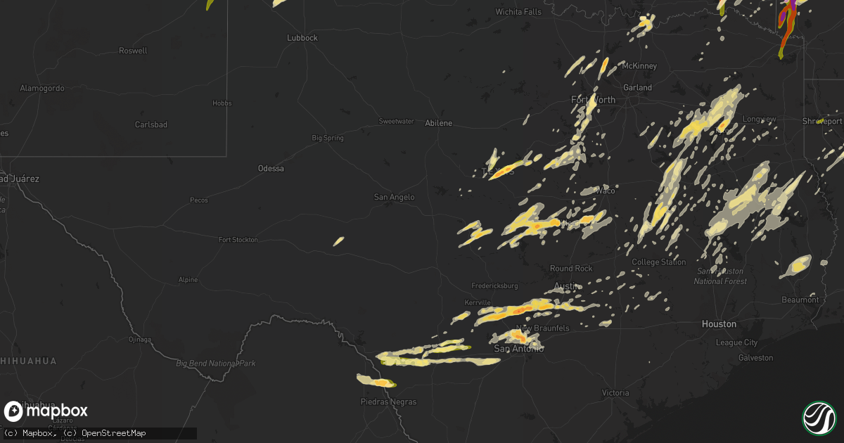
Hail Map in Texas on April 29, 2016
Get this storm
April 29 map
$229
one time, instant access
Download today. No call, no setup
Keep the $229
Bought the map and want the full workflow? Apply the entire $229 to a subscription within 7 days. None of it is wasted.
Every map, not just this one
This buys you this map. Subscription and you get every map we run, in the markets you choose from a few cities to whole states to nationwide. Plus real-time alerts the moment a storm fires.
Contact data
Name, contact info, occupancy, even credit band for addresses in the footprint. You go from where it hit to who to call.
Become the source they trust
Unlimited branding weather history reports on demand. You already have the documented answer ready for the property owner, and you are the one who showed up with it.
Property data and RoofTrace estimates
Pull up any address you have got, its value and the exact code rules for that jurisdiction, straight from One Click Code. Then RoofTrace estimates the squares, pitch, and roof value, priced the way you price.
Storm reports in Texas
Texas
| Date | Description |
|---|---|
| 04/29/20166:47 PM CDT | Quarter size hail was reported along us 87. |
| 04/29/20166:45 PM CDT | Numerous trees down...power lines down...numerous homes damaged |
| 04/29/20166:41 PM CDT | A local report indicates 1.00 inch wind near 2 SE LOMETA |
| 04/29/20166:32 PM CDT | A local report indicates 1.00 inch wind near 2 E LOMETA |
| 04/29/20166:30 PM CDT | Ozarka had its roof ripped off and 18 wheelers are overturned. |
| 04/29/20166:28 PM CDT | Several homes damage or destroyed in the shady grove area along fm 1002. |
| 04/29/20166:28 PM CDT | Numerous trees snapped and uprooted in the area of fm 1002 and fm 49. |
| 04/29/20166:23 PM CDT | At least one home damage in the fm 14 and fm 2869 area. |
| 04/29/20166:14 PM CDT | Delayed report -- received video confirmation of a weak tornado 5 se of iredell. |
| 04/29/20166:00 PM CDT | Lindale pd is reporting roof debris blocking entrances to dollar tree at 1500 s main st. Also multiple trees down in the area. |
| 04/29/20165:55 PM CDT | *** 2 inj *** numerous trees down...power lines down |
| 04/29/20165:55 PM CDT | *** 2 inj *** a long-track multi-vortex ef2 tornado with peak winds between 120-125 mph began east of lindale. Numerous trees were uprooted and snapped as it traveled n |
| 04/29/20165:54 PM CDT | Tornado on the ground at fm 16 and us 69...seen from bob wells nursery. |
| 04/29/20165:51 PM CDT | Picture on twitter of significant damage to the front of a building south of downtown lindale along hwy 69. |
| 04/29/20165:50 PM CDT | An ef2 tornado with winds estimated between 110-115 mph touched down just west of highway 69 near its intersection with mayor street. As it crossed highway 69...the tor |
| 04/29/20165:47 PM CDT | Stove pipe tornado along with power flashes observed 10 miles north of tyler pounds airport. |
| 04/29/20165:45 PM CDT | Several downed trees on the west side of hideaway lake. Roof damage to one house as well. |
| 04/29/20165:27 PM CDT | A local report indicates 1.00 inch wind near COMANCHE |
| 04/29/20165:22 PM CDT | Golfball size hail reported in ben wheeler |
| 04/29/20165:18 PM CDT | Golfball size hail 2 miles north of denton. |
| 04/29/20165:15 PM CDT | Quarter size hail reported 3 miles south of denton. |
| 04/29/20165:13 PM CDT | Delayed report....golfball reported along hwy 590 5 miles southwest of comanche. |
| 04/29/20165:00 PM CDT | The hen egg size hail busted out a vehicle window and was reported on county road 295. |
| 04/29/20164:50 PM CDT | Barn with roof damage near county road 133 and county road 134 near celina. |
| 04/29/20164:35 PM CDT | Quarter size hail report in southwest fort worth. |
| 04/29/20164:31 PM CDT | Golfball size hail reported near hulen and alta mesa in fort worth. |
| 04/29/20164:29 PM CDT | A local report indicates 1.75 inch wind near DENISON |
| 04/29/20164:19 PM CDT | A local report indicates a tornado near DORCHESTER |
| 04/29/20164:18 PM CDT | A local report indicates 1.25 inch wind near BENBROOK |
| 04/29/20164:17 PM CDT | A local report indicates 1.75 inch wind near 1 S QUEMADO |
| 04/29/20164:15 PM CDT | Quarter size hail ongoing in quemado at the time of the report. Report gathered via twitter. |
| 04/29/20163:00 PM CDT | Quarter size hail reported in jewett. |
| 04/29/20162:57 PM CDT | Golfball size hail reported in marquez. |
| 04/29/20162:25 PM CDT | A local report indicates 1.00 inch wind near 4 SE MAY |
| 04/29/20161:15 PM CDT | Half dollar size hail reported in franklin. |
| 04/29/201612:20 PM CDT | Golf ball size hail reported 2.5 miles north of tyler along hwy 69 . |
| 04/29/201612:05 PM CDT | Quarter size hail reported on hwy 69 approximately 2.5 miles south of loop 323. |
| 04/29/201612:05 PM CDT | Picture of quarter size hail along spur 364 tweeted to tyler media. |
| 04/29/201612:05 PM CDT | Pictures of golf ball size hail submitted to the tyler media from the west side of tyler around 1205 pm. |
| 04/29/20166:38 AM CDT | Trees down in snook. |
| 04/29/20166:24 AM CDT | Tree damage in deanville. |
| 04/29/20166:15 AM CDT | Facebook photo shows a tree fell on a manufactured home on county road 598. |
| 04/29/20166:08 AM CDT | *** 3 inj *** a tornado has been comfirmed along highway 96 near call. The nws employee at the scene indicates that the tornado reached an intensity of ef2 with winds a |
| 04/29/20165:55 AM CDT | A local report indicates 60 MPH wind near LEXINGTON |
| 04/29/20165:15 AM CDT | Numerous large trees...some 40 feet tall...were snapped or blown down. Time estimated with radar. |
| 04/29/20165:10 AM CDT | Sheriff dispatch reporting calls from the public near the camp swift area with a few homes with windows blown out. Power outages also being reported. |
| 04/29/20165:10 AM CDT | Emergency manager reported widespread wind damage in bastrop county...including numerous roofs torn off...windows blown out....structural damage to homes and businesses |
| 04/29/20165:08 AM CDT | The raws observation site at camp swift reported a 75 mph wind gust. |
| 04/29/20164:48 AM CDT | The austin bergstrom international airport air operations reports two 737s were damaged at their terminal gates. Planes were shifted due to 60 plus mph winds. |
| 04/29/20164:48 AM CDT | Kaus reported a 52 kt wind gust. |
| 04/29/20164:48 AM CDT | Austin fire department is reporting 15 power poles broken with lines down at the 3400 block of south us highway 183. |
| 04/29/20164:44 AM CDT | An ef-1 tornado with winds estimated between 95-105 mph touched down in the anthony harbor subdivision along highway 83...where numerous trees were snapped and uprooted |
| 04/29/20164:40 AM CDT | A local report indicates 1.00 inch wind near 3 S MENDOZA |
| 04/29/20164:20 AM CDT | Time estimated from radar |
| 04/29/20164:20 AM CDT | A local report indicates 63 MPH wind near 5 S SABINAL |
| 04/29/20164:15 AM CDT | Two lanes of northbound interstate 35 are closed near mile marker 217 due to overturned 18 wheeler likely caused by strong winds. |
| 04/29/20163:56 AM CDT | A local report indicates 1.75 inch wind near 2 SW WIMBERLEY |
| 04/29/20163:55 AM CDT | The public reported 8-10 inch diameter trees snapped about 4 to 5 feet above ground. |
| 04/29/20163:40 AM CDT | A local report indicates 2.75 inch wind near SPRING BRANCH |
| 04/29/20163:35 AM CDT | A local report indicates 1.75 inch wind near 10 NW CANYON LAKE DAM |
| 04/29/20163:31 AM CDT | A local report indicates 2.00 inch wind near 8 NW CANYON LAKE DAM |
| 04/29/20163:30 AM CDT | Golf ball sized hail in spring branch. Time estimated from radar. |
| 04/29/20163:25 AM CDT | A local report indicates 60 MPH wind near SPRING BRANCH |
| 04/29/20163:10 AM CDT | A local report indicates 1.75 inch wind near 5 N BERGHEIM |
| 04/29/20163:00 AM CDT | A local report indicates 1.75 inch wind near BOERNE |
| 04/29/20162:53 AM CDT | A local report indicates 1.75 inch wind near 2 NW BOERNE |
| 04/29/20162:40 AM CDT | Large trees down partially blocking road. |
| 04/29/20162:40 AM CDT | A local report indicates 1.50 inch wind near 6 SW NELSON CITY |
| 04/29/20161:05 AM CDT | Canoes in trees at fm 1793 and owens corner road near karnack |
| 04/29/201612:34 AM CDT | An ef1 tornado touched down just west of county road 4000 about a mile north of holmes lake. It traveled east-northeast where it intersected highway 59 near the karma f |
| 04/28/201610:47 PM CDT | Numerous trees down |
| 04/28/201610:46 PM CDT | An ef1 tornado touched down in eastern harrison county along and east of county road 2705 and traveled north-northeast...then lifted along fm 1999. Several trees were u |
| 04/28/201610:40 PM CDT | Hwy 1113 closed due to trees and power lines down |
| 04/28/201610:30 PM CDT | Numerous trees down near woodley and eddington roads near elysian fields. Possible injuries to oil field workers. |
| 04/28/201610:21 PM CDT | An ef1 tornado touched down in southern harrison county just south of county road 1311...and lifted just west of county road 1207. Numerous trees were twisted...snapped |
| 04/28/20169:47 PM CDT | Golfball size hail reported by amateur radio 1.5 miles northwest of temple |
| 04/28/20169:03 PM CDT | Golf ball sized hail falling around interstate 410 and nacogdoches rd. |
| 04/28/20169:03 PM CDT | Report via twitter with pictures of quarter to half dollar hail. |
| 04/28/20168:55 PM CDT | Spotter reports 1 inch hail 1 mile ene of copperas cove. Damage to some vehicles. |
| 04/28/20168:51 PM CDT | Public report of 1 inch hail near the intersection of blanco and bitters. Report via twitter. |
| 04/28/20168:50 PM CDT | Public report of quarter sized hail via twitter. |
| 04/28/20168:45 PM CDT | Golf ball sized hail near blanco road and ramsey. Report via twitter. |
| 04/28/20168:20 PM CDT | Numerous trees down...power lines down |
| 04/28/20168:09 PM CDT | Golfball size hail reported in lampasas. |
| 04/28/20168:05 PM CDT | Numerous trees down...power lines down |
| 04/28/20168:05 PM CDT | A local report indicates 1.50 inch wind near 4 NE FREDONIA |
| 04/28/20167:42 PM CDT | Reports of extensive damage has been received near alto. A barn was blown over. |
All States Impacted by Hail Map on April 29, 2016
Cities Impacted by Hail Map on April 29, 2016
- Fayetteville, TX
- Brownwood, TX
- Dublin, TX
- Blanket, TX
- Comanche, TX
- Zephyr, TX
- Carlton, TX
- Early, TX
- Gustine, TX
- Ponder, TX
- Birmingham, AL
- West Monroe, LA
- Etoile, TX
- Athens, TX
- Ben Wheeler, TX
- Gause, TX
- Milano, TX
- Randolph, AL
- Jemison, AL
- Brierfield, AL
- Calera, AL
- Montevallo, AL
- Columbus, MS
- Ethelsville, AL
- Morgan, TX
- Kopperl, TX
- Little Rock, AR
- Ames, OK
- Meno, OK
- Chireno, TX
- Center, TX
- San Augustine, TX
- Medina, TX
- Austin, TX
- Dripping Springs, TX
- Uvalde, TX
- Van Buren, AR
- Normangee, TX
- Franklin, TX
- Marquez, TX
- Welch, OK
- Chetopa, KS
- Bartlett, KS
- Mansfield, LA
- West Point, MS
- Coker, AL
- Tuscaloosa, AL
- Northport, AL
- Cedar Vale, KS
- Buhl, AL
- Brookwood, AL
- Berry, AL
- Gordo, AL
- Elrod, AL
- Hearne, TX
- Buffalo, TX
- Oakwood, TX
- Jewett, TX
- Calvert, TX
- Kempner, TX
- Copperas Cove, TX
- Lawton, OK
- Frederick, OK
- Tipton, OK
- Indiahoma, OK
- Snyder, OK
- Lovelady, TX
- Oxford, MS
- Abbeville, MS
- Gilmer, TX
- Winnsboro, TX
- Fairfield, TX
- Teague, TX
- Tennessee Colony, TX
- Shorter, AL
- Tallassee, AL
- Wetumpka, AL
- Pike Road, AL
- Tuskegee, AL
- Walnut Springs, TX
- Iredell, TX
- Meridian, TX
- Hale Center, TX
- Plainview, TX
- Call, TX
- Merryville, LA
- Bon Wier, TX
- May, TX
- Concan, TX
- Steens, MS
- Murchison, TX
- Trinity, TX
- Stuttgart, AR
- Fredonia, TX
- Mason, TX
- Cherokee, TX
- Voca, TX
- San Saba, TX
- Mountain View, OK
- Fletcher, OK
- Cyril, OK
- Cement, OK
- Medicine Park, OK
- Elgin, OK
- Carnegie, OK
- Apache, OK
- Oak Grove, LA
- Kennedy, AL
- Fayette, AL
- Quemado, TX
- Big Sandy, TX
- Atascosa, TX
- Natalia, TX
- Sabinal, TX
- La Coste, TX
- Lytle, TX
- Knippa, TX
- Brackettville, TX
- Hondo, TX
- Devine, TX
- D Hanis, TX
- Helotes, TX
- San Antonio, TX
- Muldrow, OK
- Ada, OK
- Palestine, TX
- Eufaula, OK
- Boynton, OK
- Council Hill, OK
- Checotah, OK
- Henryetta, OK
- Warren, AR
- Duck Hill, MS
- Donie, TX
- Cooper, TX
- Thorsby, AL
- Clanton, AL
- Kirbyville, TX
- Nacogdoches, TX
- Garrison, TX
- Elmore City, OK
- Montgomery, AL
- Konawa, OK
- Canton, TX
- Van, TX
- Goldthwaite, TX
- Silsbee, TX
- Buna, TX
- Fred, TX
- Spurger, TX
- Dubach, LA
- Rockwood, TX
- Burton, TX
- Ledbetter, TX
- Carmine, TX
- Skiatook, OK
- Longdale, OK
- Canton, OK
- Krum, TX
- Denton, TX
- Lampasas, TX
- Fort Sill, OK
- Brady, TX
- Rochelle, TX
- Lott, TX
- Rosebud, TX
- Crockett, TX
- Grapeland, TX
- Idabel, OK
- Lufkin, TX
- Grand Saline, TX
- Tyler, TX
- Seminole, OK
- Mcloud, OK
- Norman, OK
- Shawnee, OK
- Okemah, OK
- Wewoka, OK
- Earlsboro, OK
- Prague, OK
- Paden, OK
- Newalla, OK
- Tecumseh, OK
- Spring Branch, TX
- Llano, TX
- Hanna, OK
- Tow, TX
- Buchanan Dam, TX
- Bend, TX
- Killeen, TX
- Bluffton, TX
- Fort Hood, TX
- Lometa, TX
- Wills Point, TX
- Blanco, TX
- Bastrop, TX
- Kerrville, TX
- Del Valle, TX
- Bandera, TX
- Center Point, TX
- San Marcos, TX
- Red Rock, TX
- Comfort, TX
- Boerne, TX
- Driftwood, TX
- Kendalia, TX
- Dale, TX
- Pipe Creek, TX
- Fischer, TX
- Buda, TX
- Kyle, TX
- Wimberley, TX
- Canyon Lake, TX
- Lockhart, TX
- Smithville, TX
- Porter, OK
- Humnoke, AR
- Fort Worth, TX
- Vernon, AL
- Godley, TX
- Ringgold, LA
- Joshua, TX
- Burleson, TX
- Cleburne, TX
- Hamburg, AR
- Cedar Creek, TX
- Hereford, TX
- Ruston, LA
- Brenham, TX
- Chickasha, OK
- Ninnekah, OK
- Broken Arrow, OK
- Coweta, OK
- Blackwell, OK
- Braman, OK
- Crowley, TX
- Haltom City, TX
- Wynnewood, OK
- Howe, TX
- Whitesboro, TX
- Arkansas City, KS
- Fosters, AL
- Littlefield, TX
- Van Alstyne, TX
- Scurry, TX
- Trafford, AL
- West Blocton, AL
- Evansville, AR
- Canehill, AR
- Natural Dam, AR
- Cedarville, AR
- West Fork, AR
- Uniontown, AR
- Stilwell, OK
- Sallisaw, OK
- Prairie Grove, AR
- Gans, OK
- Coushatta, LA
- Burnet, TX
- Valley Spring, TX
- Gatesville, TX
- Bryan, TX
- Winona, TX
- Arp, TX
- Shelbyville, TX
- Zavalla, TX
- Huntington, TX
- Moody, TX
- Troy, TX
- Temple, TX
- Belton, TX
- Hico, TX
- Altus Afb, OK
- Altus, OK
- Headrick, OK
- Decatur, TX
- Eclectic, AL
- Roosevelt, OK
- Dierks, AR
- Bastrop, LA
- Corrigan, TX
- Cherryvale, KS
- Dennis, KS
- Thayer, KS
- Philipp, MS
- Mount Enterprise, TX
- Washington, OK
- Blanchard, OK
- Marion, AL
- Greensboro, AL
- Dexter, KS
- Eagletown, OK
- Broken Bow, OK
- De Queen, AR
- Houston, MS
- Hope Hull, AL
- Sawyer, OK
- Fort Towson, OK
- Alma, AR
- Walters, OK
- Duncan, OK
- Cedarbluff, MS
- Pheba, MS
- Starkville, MS
- New Waverly, TX
- Willis, TX
- Sterlington, LA
- Lindale, TX
- Thornton, TX
- Gardendale, AL
- Chattanooga, OK
- Faxon, OK
- Mountain Park, OK
- Amber, OK
- Anadarko, OK
- Geronimo, OK
- Cache, OK
- Alex, OK
- Pauls Valley, OK
- Noel, MO
- Sulphur Springs, AR
- Gravette, AR
- South West City, MO
- Amity, AR
- Glenwood, AR
- Caddo Gap, AR
- Kirby, AR
- Universal City, TX
- Converse, TX
- Ponca City, OK
- Parsons, KS
- Galesburg, KS
- Centerville, TX
- Cameron, OK
- Pocola, OK
- Harker Heights, TX
- Brownsboro, TX
- Eustace, TX
- Elk City, KS
- Cartwright, OK
- Colbert, OK
- Denison, TX
- Mineral Springs, AR
- Nashville, AR
- Overton, TX
- Pampa, TX
- Utopia, TX
- Streetman, TX
- Pearcy, AR
- Bonnerdale, AR
- Bismarck, AR
- Seiling, OK
- Leola, AR
- Valley Mills, TX
- Deer Creek, OK
- Fredonia, KS
- Elk Falls, KS
- Maple City, KS
- Longton, KS
- Cambridge, KS
- Moline, KS
- Altoona, KS
- South Haven, KS
- Medford, OK
- Sedan, KS
- Lamont, OK
- Shidler, OK
- Neodesha, KS
- Grenola, KS
- Independence, KS
- Geuda Springs, KS
- Newkirk, OK
- Nardin, OK
- Bertram, TX
- Ringling, OK
- Wilson, OK
- Woodway, TX
- Crawford, TX
- Amory, MS
- Santa Anna, TX
- Nashoba, OK
- Rattan, OK
- Madisonville, TX
- North Zulch, TX
- Mantee, MS
- Malvern, AR
- Polk City, FL
- New Braunfels, TX
- Hodgen, OK
- Muse, OK
- Anderson, TX
- Bedias, TX
- Iola, TX
- Bellville, TX
- Bleiblerville, TX
- Chappell Hill, TX
- Muldoon, TX
- Flatonia, TX
- Catoosa, OK
- Mount Pleasant, TX
- Booneville, MS
- Rienzi, MS
- Okmulgee, OK
- Morris, OK
- Redbird, OK
- Inola, OK
- Haskell, OK
- Wagoner, OK
- Adger, AL
- Sheridan, AR
- Double Springs, AL
- Paradise, TX
- Autaugaville, AL
- Stonewall, OK
- Fitzhugh, OK
- Converse, LA
- Kress, TX
- Ringwood, OK
- Goltry, OK
- Gillham, AR
- Detroit, TX
- Blossom, TX
- Gould, AR
- Yorktown, AR
- Powell, TX
- Corsicana, TX
- Rice, TX
- Chatfield, TX
- Kemp, TX
- Pond Creek, OK
- Sherman, TX
- Almyra, AR
- Bradley, OK
- Rush Springs, OK
- Olustee, OK
- Comanche, OK
- Lindsay, OK
- Loveland, OK
- Marlow, OK
- Duke, OK
- Eldorado, OK
- Clifton, TX
- Ozona, TX
- Smithville, OK
- Talihina, OK
- Honobia, OK
- Whitesboro, OK
- Bethel, OK
- Heavener, OK
- Fittstown, OK
- Kerens, TX
- Tatum, TX
- Homer, LA
- Arcadia, LA
- Bernice, LA
- Kilgore, TX
- Troup, TX
- Whitehouse, TX
- Mill Creek, OK
- Millport, AL
- Vance, AL
- Apple Springs, TX
- Pennington, TX
- Groveton, TX
- Wells, TX
- Pollok, TX
- Alto, TX
- Douglass, TX
- Kennard, TX
- Nemo, TX
- Prosper, TX
- Little Elm, TX
- Aubrey, TX
- Helena, AL
- Princeton, LA
- Aliceville, AL
- Eutaw, AL
- Fort Smith, AR
- Lavaca, AR
- Hawkins, TX
- Mineola, TX
- Farmerville, LA
- Collinston, LA
- Marion, LA
- Downsville, LA
- Jones, LA
- Bonita, LA
- Mer Rouge, LA
- Hanceville, AL
- Bremen, AL
- Mobeetie, TX
- Greenwood Springs, MS
- Groesbeck, TX
- Waterford, MS
- Como, MS
- Monticello, AR
- Orange, TX
- Rising Star, TX
- Sidney, TX
- Portland, AR
- Davis, OK
- Stratford, OK
- Argyle, TX
- Sanger, TX
- La Grange, TX
- Round Top, TX
- Bells, TX
- Huntsville, TX
- Oakhurst, TX
- Dennis, MS
- Guin, AL
- Brilliant, AL
- Hamilton, AL
- Hillsboro, TX
- Sulphur, OK
- Broaddus, TX
- Somerville, TX
- Caldwell, TX
- Fieldton, TX
- Olton, TX
- Amherst, TX
- Mena, AR
- Wickes, AR
- Grannis, AR
- Umpire, AR
- Vanderpool, TX
- Coldspring, TX
- Montalba, TX
- Artesia, MS
- Caledonia, MS
- Wright City, OK
- Valliant, OK
- Garvin, OK
- New Edinburg, AR
- Lyon, MS
- Roanoke, TX
- Altamont, KS
- Springtown, TX
- Paige, TX
- Bullard, TX
- Jbsa Randolph, TX
- Cibolo, TX
- Schertz, TX
- Trussville, AL
- Sparkman, AR
- McGregor, TX
- Chandler, TX
- Midway, TX
- Dermott, AR
- Murfreesboro, AR
- Maben, MS
- Longview, TX
- Sand Springs, OK
- Sapulpa, OK
- Mountainburg, AR
- Rudy, AR
- Buffalo, OK
- Hugo, OK
- Florence, TX
- Roff, OK
- Clarksville, TX
- Winfield, KS
- Noble, OK
- Lexington, OK
- Bienville, LA
- Mingus, TX
- Gordon, TX
- Dora, AL
- Warrior, AL
- Empire, AL
- Hall Summit, LA
- Carrollton, AL
- Hendrix, OK
- Lincoln, TX
- Dime Box, TX
- Lexington, TX
- Watonga, OK
- Oakwood, OK
- Fay, OK
- Paris, TX
- Saint Hedwig, TX
- Leeds, AL
- Moody, AL
- England, AR
- Moundville, AL
- Oktaha, OK
- Pointblank, TX
- Warren, TX
- Jet, OK
- Nash, OK
- Helena, OK
- Conway Springs, KS
- Elkhart, TX
- Choudrant, LA
- Monroe, LA
- Wilmot, AR
- Milam, TX
- Noble, LA
- Rosanky, TX
- Waelder, TX
- Leona, TX
- Stillwater, OK
- Tillar, AR
- New Site, MS
- Belmont, MS
- Kountze, TX
- Louise, TX
- Arkadelphia, AR
- Claremore, OK
- Neosho, MO
- Goodman, MO
- Covington, TX
- Coffeyville, KS
- Grand Cane, LA
- Pittsburg, TX
- Quitman, TX
- Malakoff, TX
- Flint, TX
- Eddy, TX
- Union Springs, AL
- Fitzpatrick, AL
- Livingston, TX
- Moscow, TX
- Chouteau, OK
- Merigold, MS
- Lowndesboro, AL
- Castor, LA
- Lockesburg, AR
- Hot Springs National Park, AR
- Donaldson, AR
- Evant, TX
- Hamilton, TX
- Perry, OK
- Giddings, TX
- Martindale, TX
- Maxwell, TX
- McCalla, AL
- Jbsa Lackland, TX
- Okolona, MS
- Wilmar, AR
- Cushing, TX
- Luling, TX
- Drew, MS
- McCarley, MS
- Axtell, TX
- Jonesboro, LA
- Saline, LA
- Marion, TX
- Langley, AR
- Wichita, KS
- Bruce, MS
- Pittsboro, MS
- Bangs, TX
- Grenada, MS
- White Hall, AR
- Happy, TX
- Wellington, TX
- Dodson, TX
- Howe, OK
- Poteau, OK
- Anderson, MO
- Jay, OK
- Oakland, TN
- Somerville, TN
- Cullman, AL
- Bremond, TX
- Winona, MS
- Chelsea, OK
- Haleyville, AL
- Lynn, AL
- Houlka, MS
- McDade, TX
- Clermont, FL
- Waco, TX
- Mabank, TX
- Henderson, TX
- Parkdale, AR
- Eudora, AR
- Huttig, AR
- Holcomb, MS
- Benton, AR
- Carrollton, MS
- Ulm, AR
- Carlisle, AR
- Kilmichael, MS
- Crawford, MS
- Potts Camp, MS
- Chilton, TX
- Holland, TX
- Nolanville, TX
- Little River Academy, TX
- Salado, TX
- Rhome, TX
- West Point, TX
- Rio Medina, TX
- Mico, TX
- La Vernia, TX
- Jbsa Ft Sam Houston, TX
- Adkins, TX
- Mulberry, AR
- Tulia, TX
- Carthage, AR
- Eupora, MS
- Cleveland, MS
- Calhoun City, MS
- Weleetka, OK
- Bossier City, LA
- De Valls Bluff, AR
- Rio Vista, TX
- Morris, AL
- Pinson, AL
- Conroe, TX
- Taloga, OK
- Leesburg, TX
- Vidor, TX
- Mount Olive, AL
- Tolar, TX
- Byars, OK
- Chester, TX
- Hollis, OK
- Scroggins, TX
- Arkoma, OK
- Hackett, AR
- Arcadia, FL
- Canute, OK
- Dill City, OK
- Foss, OK
- Niotaze, KS
- Havana, KS
- Crossett, AR
- Greenwood, AR
- Ore City, TX
- Diboll, TX
- Tuskegee Institute, AL
- Hardaway, AL
- Calhoun, LA
- Eros, LA
- Gattman, MS
- Sulligent, AL
- Scott, AR
- Lonoke, AR
- Larue, TX
- Cameron, TX
- Thomas, OK
- Oklahoma City, OK
- Newcastle, OK
- Boley, OK
- Purcell, OK
- Foster, OK
- Waurika, OK
- Mcalester, OK
- Cleveland, TX
- Cresson, TX
- Enid, OK
- Blum, TX
- Liberty, KS
- Mound Valley, KS
- Bixby, OK
- Mounds, OK
- Maud, OK
- Grandview, TX
- Delaware, OK
- Hallsville, TX
- Beckville, TX
- Wanette, OK
- Asher, OK
- Macomb, OK
- Jacksonville, TX
- Gurdon, AR
- Water Valley, MS
- Coffeeville, MS
- Saint Paul, KS
- Carrier, OK
- Kremlin, OK
- Groom, TX
- Charleston, MS
- Minter City, MS
- Bulverde, TX
- Redfield, AR
- Jefferson, AR
- Shreveport, LA
- Laverne, OK
- Claude, TX
- Onalaska, TX
- Caney, KS
- Kingsland, AR
- Ivan, AR
- Bearden, AR
- Thornton, AR
- Fordyce, AR
- Prattsville, AR
- Lake Dallas, TX
- Flower Mound, TX
- Lewisville, TX
- Itta Bena, MS
- Schlater, MS
- Itasca, TX
- Aledo, TX
- Weatherford, TX
- Oakland, MS
- Enid, MS
- Glen Rose, TX
- Sulphur Springs, TX
- Tucker, AR
- Sherrill, AR
- Art, TX
- Lanagan, MO
- Mathews, AL
- Frierson, LA
- Pelican, LA
- Kosse, TX
- Trinidad, TX
- Sunflower, MS
- Prairie, MS
- Aberdeen, MS
- Hamilton, MS
- Whitney, TX
- Logan, AL
- Arley, AL
- Crane Hill, AL
- Harwood, TX
- Bronson, TX
- Tonkawa, OK
- Leakey, TX
- Vardaman, MS
- Frankston, TX
- Grant, OK
- Calera, OK
- Centreville, AL
- Brent, AL
- Ennis, TX
- Boyd, TX
- Burlington, TX
- Newhope, AR
- Elgin, TX
- Graham, TX
- Newcastle, TX
- Dundee, MS
- Tunica, MS
- Deport, TX
- Briggs, TX
- Brookside, AL
- Graysville, AL
- Sumiton, AL
- Cascilla, MS
- Keller, TX
- Castle, OK
- Maysville, OK
- Lonsdale, AR
- Hot Springs Village, AR
- Winfield, AL
- Senatobia, MS
- Paron, AR
- Manor, TX
- Tishomingo, OK
- Texico, NM
- Farwell, TX
- Portales, NM
- Rogers, NM
- Horatio, AR
- Ashdown, AR
- Foreman, AR
- Winthrop, AR
- Alleene, AR
- Maud, TX
- New Boston, TX
- Hooks, TX
- Snow, OK
- Hurst, TX
- Southlake, TX
- North Richland Hills, TX
- Marietta, OK
- Saint Jo, TX
- Kenefic, OK
- Pottsboro, TX
- Durant, OK
- Mead, OK
- Madill, OK
- Kingston, OK
- Scobey, MS
- Beaver, OK
- Balko, OK
- Kimberly, AL
- Docena, AL
- Winslow, AR
- Ozark, AR
- Holdenville, OK
- Tussy, OK
- Mannsville, OK


