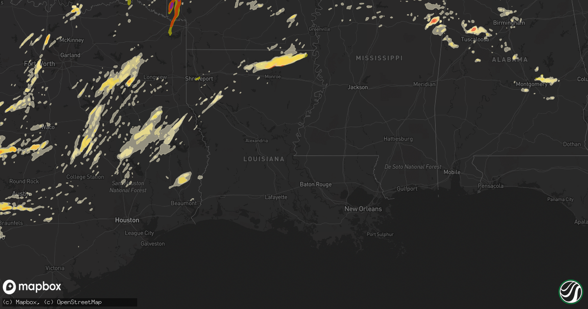
Hail Map in Louisiana on April 29, 2016
Get this storm
April 29 map
$229
one time, instant access
Download today. No call, no setup
Keep the $229
Bought the map and want the full workflow? Apply the entire $229 to a subscription within 7 days. None of it is wasted.
Every map, not just this one
This buys you this map. Subscription and you get every map we run, in the markets you choose from a few cities to whole states to nationwide. Plus real-time alerts the moment a storm fires.
Contact data
Name, contact info, occupancy, even credit band for addresses in the footprint. You go from where it hit to who to call.
Become the source they trust
Unlimited branding weather history reports on demand. You already have the documented answer ready for the property owner, and you are the one who showed up with it.
Property data and RoofTrace estimates
Pull up any address you have got, its value and the exact code rules for that jurisdiction, straight from One Click Code. Then RoofTrace estimates the squares, pitch, and roof value, priced the way you price.
Storm reports in Louisiana
Louisiana
| Date | Description |
|---|---|
| 04/29/20164:25 PM CDT | A local report indicates 1.50 inch wind near 3 NNW OAK GROVE |
| 04/29/20163:44 PM CDT | A local report indicates 1.00 inch wind near MER ROUGE |
| 04/29/20163:30 PM CDT | Dents were reported in cars |
| 04/29/20163:20 PM CDT | Quarter-sized hail covering the ground... |
| 04/29/20163:11 PM CDT | Quarter and nickel sized hail covering the ground in rocky branch community... |
| 04/29/20163:10 PM CDT | A local report indicates 1.75 inch wind near BASTROP |
| 04/29/20163:02 PM CDT | A local report indicates 1.75 inch wind near 2 NW BASTROP |
| 04/29/201612:25 PM CDT | Picture posted to our facebook page of 1 inch hail in the mooretown area. |
| 04/29/20161:12 AM CDT | Swepco reports 4000 customers without power in caddo and bossier parishes as well as harrison county |
All States Impacted by Hail Map on April 29, 2016
Cities Impacted by Hail Map on April 29, 2016
- Fayetteville, TX
- Brownwood, TX
- Dublin, TX
- Blanket, TX
- Comanche, TX
- Zephyr, TX
- Carlton, TX
- Early, TX
- Gustine, TX
- Ponder, TX
- Birmingham, AL
- West Monroe, LA
- Etoile, TX
- Athens, TX
- Ben Wheeler, TX
- Gause, TX
- Milano, TX
- Randolph, AL
- Jemison, AL
- Brierfield, AL
- Calera, AL
- Montevallo, AL
- Columbus, MS
- Ethelsville, AL
- Morgan, TX
- Kopperl, TX
- Little Rock, AR
- Ames, OK
- Meno, OK
- Chireno, TX
- Center, TX
- San Augustine, TX
- Medina, TX
- Austin, TX
- Dripping Springs, TX
- Uvalde, TX
- Van Buren, AR
- Normangee, TX
- Franklin, TX
- Marquez, TX
- Welch, OK
- Chetopa, KS
- Bartlett, KS
- Mansfield, LA
- West Point, MS
- Coker, AL
- Tuscaloosa, AL
- Northport, AL
- Cedar Vale, KS
- Buhl, AL
- Brookwood, AL
- Berry, AL
- Gordo, AL
- Elrod, AL
- Hearne, TX
- Buffalo, TX
- Oakwood, TX
- Jewett, TX
- Calvert, TX
- Kempner, TX
- Copperas Cove, TX
- Lawton, OK
- Frederick, OK
- Tipton, OK
- Indiahoma, OK
- Snyder, OK
- Lovelady, TX
- Oxford, MS
- Abbeville, MS
- Gilmer, TX
- Winnsboro, TX
- Fairfield, TX
- Teague, TX
- Tennessee Colony, TX
- Shorter, AL
- Tallassee, AL
- Wetumpka, AL
- Pike Road, AL
- Tuskegee, AL
- Walnut Springs, TX
- Iredell, TX
- Meridian, TX
- Hale Center, TX
- Plainview, TX
- Call, TX
- Merryville, LA
- Bon Wier, TX
- May, TX
- Concan, TX
- Steens, MS
- Murchison, TX
- Trinity, TX
- Stuttgart, AR
- Fredonia, TX
- Mason, TX
- Cherokee, TX
- Voca, TX
- San Saba, TX
- Mountain View, OK
- Fletcher, OK
- Cyril, OK
- Cement, OK
- Medicine Park, OK
- Elgin, OK
- Carnegie, OK
- Apache, OK
- Oak Grove, LA
- Kennedy, AL
- Fayette, AL
- Quemado, TX
- Big Sandy, TX
- Atascosa, TX
- Natalia, TX
- Sabinal, TX
- La Coste, TX
- Lytle, TX
- Knippa, TX
- Brackettville, TX
- Hondo, TX
- Devine, TX
- D Hanis, TX
- Helotes, TX
- San Antonio, TX
- Muldrow, OK
- Ada, OK
- Palestine, TX
- Eufaula, OK
- Boynton, OK
- Council Hill, OK
- Checotah, OK
- Henryetta, OK
- Warren, AR
- Duck Hill, MS
- Donie, TX
- Cooper, TX
- Thorsby, AL
- Clanton, AL
- Kirbyville, TX
- Nacogdoches, TX
- Garrison, TX
- Elmore City, OK
- Montgomery, AL
- Konawa, OK
- Canton, TX
- Van, TX
- Goldthwaite, TX
- Silsbee, TX
- Buna, TX
- Fred, TX
- Spurger, TX
- Dubach, LA
- Rockwood, TX
- Burton, TX
- Ledbetter, TX
- Carmine, TX
- Skiatook, OK
- Longdale, OK
- Canton, OK
- Krum, TX
- Denton, TX
- Lampasas, TX
- Fort Sill, OK
- Brady, TX
- Rochelle, TX
- Lott, TX
- Rosebud, TX
- Crockett, TX
- Grapeland, TX
- Idabel, OK
- Lufkin, TX
- Grand Saline, TX
- Tyler, TX
- Seminole, OK
- Mcloud, OK
- Norman, OK
- Shawnee, OK
- Okemah, OK
- Wewoka, OK
- Earlsboro, OK
- Prague, OK
- Paden, OK
- Newalla, OK
- Tecumseh, OK
- Spring Branch, TX
- Llano, TX
- Hanna, OK
- Tow, TX
- Buchanan Dam, TX
- Bend, TX
- Killeen, TX
- Bluffton, TX
- Fort Hood, TX
- Lometa, TX
- Wills Point, TX
- Blanco, TX
- Bastrop, TX
- Kerrville, TX
- Del Valle, TX
- Bandera, TX
- Center Point, TX
- San Marcos, TX
- Red Rock, TX
- Comfort, TX
- Boerne, TX
- Driftwood, TX
- Kendalia, TX
- Dale, TX
- Pipe Creek, TX
- Fischer, TX
- Buda, TX
- Kyle, TX
- Wimberley, TX
- Canyon Lake, TX
- Lockhart, TX
- Smithville, TX
- Porter, OK
- Humnoke, AR
- Fort Worth, TX
- Vernon, AL
- Godley, TX
- Ringgold, LA
- Joshua, TX
- Burleson, TX
- Cleburne, TX
- Hamburg, AR
- Cedar Creek, TX
- Hereford, TX
- Ruston, LA
- Brenham, TX
- Chickasha, OK
- Ninnekah, OK
- Broken Arrow, OK
- Coweta, OK
- Blackwell, OK
- Braman, OK
- Crowley, TX
- Haltom City, TX
- Wynnewood, OK
- Howe, TX
- Whitesboro, TX
- Arkansas City, KS
- Fosters, AL
- Littlefield, TX
- Van Alstyne, TX
- Scurry, TX
- Trafford, AL
- West Blocton, AL
- Evansville, AR
- Canehill, AR
- Natural Dam, AR
- Cedarville, AR
- West Fork, AR
- Uniontown, AR
- Stilwell, OK
- Sallisaw, OK
- Prairie Grove, AR
- Gans, OK
- Coushatta, LA
- Burnet, TX
- Valley Spring, TX
- Gatesville, TX
- Bryan, TX
- Winona, TX
- Arp, TX
- Shelbyville, TX
- Zavalla, TX
- Huntington, TX
- Moody, TX
- Troy, TX
- Temple, TX
- Belton, TX
- Hico, TX
- Altus Afb, OK
- Altus, OK
- Headrick, OK
- Decatur, TX
- Eclectic, AL
- Roosevelt, OK
- Dierks, AR
- Bastrop, LA
- Corrigan, TX
- Cherryvale, KS
- Dennis, KS
- Thayer, KS
- Philipp, MS
- Mount Enterprise, TX
- Washington, OK
- Blanchard, OK
- Marion, AL
- Greensboro, AL
- Dexter, KS
- Eagletown, OK
- Broken Bow, OK
- De Queen, AR
- Houston, MS
- Hope Hull, AL
- Sawyer, OK
- Fort Towson, OK
- Alma, AR
- Walters, OK
- Duncan, OK
- Cedarbluff, MS
- Pheba, MS
- Starkville, MS
- New Waverly, TX
- Willis, TX
- Sterlington, LA
- Lindale, TX
- Thornton, TX
- Gardendale, AL
- Chattanooga, OK
- Faxon, OK
- Mountain Park, OK
- Amber, OK
- Anadarko, OK
- Geronimo, OK
- Cache, OK
- Alex, OK
- Pauls Valley, OK
- Noel, MO
- Sulphur Springs, AR
- Gravette, AR
- South West City, MO
- Amity, AR
- Glenwood, AR
- Caddo Gap, AR
- Kirby, AR
- Universal City, TX
- Converse, TX
- Ponca City, OK
- Parsons, KS
- Galesburg, KS
- Centerville, TX
- Cameron, OK
- Pocola, OK
- Harker Heights, TX
- Brownsboro, TX
- Eustace, TX
- Elk City, KS
- Cartwright, OK
- Colbert, OK
- Denison, TX
- Mineral Springs, AR
- Nashville, AR
- Overton, TX
- Pampa, TX
- Utopia, TX
- Streetman, TX
- Pearcy, AR
- Bonnerdale, AR
- Bismarck, AR
- Seiling, OK
- Leola, AR
- Valley Mills, TX
- Deer Creek, OK
- Fredonia, KS
- Elk Falls, KS
- Maple City, KS
- Longton, KS
- Cambridge, KS
- Moline, KS
- Altoona, KS
- South Haven, KS
- Medford, OK
- Sedan, KS
- Lamont, OK
- Shidler, OK
- Neodesha, KS
- Grenola, KS
- Independence, KS
- Geuda Springs, KS
- Newkirk, OK
- Nardin, OK
- Bertram, TX
- Ringling, OK
- Wilson, OK
- Woodway, TX
- Crawford, TX
- Amory, MS
- Santa Anna, TX
- Nashoba, OK
- Rattan, OK
- Madisonville, TX
- North Zulch, TX
- Mantee, MS
- Malvern, AR
- Polk City, FL
- New Braunfels, TX
- Hodgen, OK
- Muse, OK
- Anderson, TX
- Bedias, TX
- Iola, TX
- Bellville, TX
- Bleiblerville, TX
- Chappell Hill, TX
- Muldoon, TX
- Flatonia, TX
- Catoosa, OK
- Mount Pleasant, TX
- Booneville, MS
- Rienzi, MS
- Okmulgee, OK
- Morris, OK
- Redbird, OK
- Inola, OK
- Haskell, OK
- Wagoner, OK
- Adger, AL
- Sheridan, AR
- Double Springs, AL
- Paradise, TX
- Autaugaville, AL
- Stonewall, OK
- Fitzhugh, OK
- Converse, LA
- Kress, TX
- Ringwood, OK
- Goltry, OK
- Gillham, AR
- Detroit, TX
- Blossom, TX
- Gould, AR
- Yorktown, AR
- Powell, TX
- Corsicana, TX
- Rice, TX
- Chatfield, TX
- Kemp, TX
- Pond Creek, OK
- Sherman, TX
- Almyra, AR
- Bradley, OK
- Rush Springs, OK
- Olustee, OK
- Comanche, OK
- Lindsay, OK
- Loveland, OK
- Marlow, OK
- Duke, OK
- Eldorado, OK
- Clifton, TX
- Ozona, TX
- Smithville, OK
- Talihina, OK
- Honobia, OK
- Whitesboro, OK
- Bethel, OK
- Heavener, OK
- Fittstown, OK
- Kerens, TX
- Tatum, TX
- Homer, LA
- Arcadia, LA
- Bernice, LA
- Kilgore, TX
- Troup, TX
- Whitehouse, TX
- Mill Creek, OK
- Millport, AL
- Vance, AL
- Apple Springs, TX
- Pennington, TX
- Groveton, TX
- Wells, TX
- Pollok, TX
- Alto, TX
- Douglass, TX
- Kennard, TX
- Nemo, TX
- Prosper, TX
- Little Elm, TX
- Aubrey, TX
- Helena, AL
- Princeton, LA
- Aliceville, AL
- Eutaw, AL
- Fort Smith, AR
- Lavaca, AR
- Hawkins, TX
- Mineola, TX
- Farmerville, LA
- Collinston, LA
- Marion, LA
- Downsville, LA
- Jones, LA
- Bonita, LA
- Mer Rouge, LA
- Hanceville, AL
- Bremen, AL
- Mobeetie, TX
- Greenwood Springs, MS
- Groesbeck, TX
- Waterford, MS
- Como, MS
- Monticello, AR
- Orange, TX
- Rising Star, TX
- Sidney, TX
- Portland, AR
- Davis, OK
- Stratford, OK
- Argyle, TX
- Sanger, TX
- La Grange, TX
- Round Top, TX
- Bells, TX
- Huntsville, TX
- Oakhurst, TX
- Dennis, MS
- Guin, AL
- Brilliant, AL
- Hamilton, AL
- Hillsboro, TX
- Sulphur, OK
- Broaddus, TX
- Somerville, TX
- Caldwell, TX
- Fieldton, TX
- Olton, TX
- Amherst, TX
- Mena, AR
- Wickes, AR
- Grannis, AR
- Umpire, AR
- Vanderpool, TX
- Coldspring, TX
- Montalba, TX
- Artesia, MS
- Caledonia, MS
- Wright City, OK
- Valliant, OK
- Garvin, OK
- New Edinburg, AR
- Lyon, MS
- Roanoke, TX
- Altamont, KS
- Springtown, TX
- Paige, TX
- Bullard, TX
- Jbsa Randolph, TX
- Cibolo, TX
- Schertz, TX
- Trussville, AL
- Sparkman, AR
- McGregor, TX
- Chandler, TX
- Midway, TX
- Dermott, AR
- Murfreesboro, AR
- Maben, MS
- Longview, TX
- Sand Springs, OK
- Sapulpa, OK
- Mountainburg, AR
- Rudy, AR
- Buffalo, OK
- Hugo, OK
- Florence, TX
- Roff, OK
- Clarksville, TX
- Winfield, KS
- Noble, OK
- Lexington, OK
- Bienville, LA
- Mingus, TX
- Gordon, TX
- Dora, AL
- Warrior, AL
- Empire, AL
- Hall Summit, LA
- Carrollton, AL
- Hendrix, OK
- Lincoln, TX
- Dime Box, TX
- Lexington, TX
- Watonga, OK
- Oakwood, OK
- Fay, OK
- Paris, TX
- Saint Hedwig, TX
- Leeds, AL
- Moody, AL
- England, AR
- Moundville, AL
- Oktaha, OK
- Pointblank, TX
- Warren, TX
- Jet, OK
- Nash, OK
- Helena, OK
- Conway Springs, KS
- Elkhart, TX
- Choudrant, LA
- Monroe, LA
- Wilmot, AR
- Milam, TX
- Noble, LA
- Rosanky, TX
- Waelder, TX
- Leona, TX
- Stillwater, OK
- Tillar, AR
- New Site, MS
- Belmont, MS
- Kountze, TX
- Louise, TX
- Arkadelphia, AR
- Claremore, OK
- Neosho, MO
- Goodman, MO
- Covington, TX
- Coffeyville, KS
- Grand Cane, LA
- Pittsburg, TX
- Quitman, TX
- Malakoff, TX
- Flint, TX
- Eddy, TX
- Union Springs, AL
- Fitzpatrick, AL
- Livingston, TX
- Moscow, TX
- Chouteau, OK
- Merigold, MS
- Lowndesboro, AL
- Castor, LA
- Lockesburg, AR
- Hot Springs National Park, AR
- Donaldson, AR
- Evant, TX
- Hamilton, TX
- Perry, OK
- Giddings, TX
- Martindale, TX
- Maxwell, TX
- McCalla, AL
- Jbsa Lackland, TX
- Okolona, MS
- Wilmar, AR
- Cushing, TX
- Luling, TX
- Drew, MS
- McCarley, MS
- Axtell, TX
- Jonesboro, LA
- Saline, LA
- Marion, TX
- Langley, AR
- Wichita, KS
- Bruce, MS
- Pittsboro, MS
- Bangs, TX
- Grenada, MS
- White Hall, AR
- Happy, TX
- Wellington, TX
- Dodson, TX
- Howe, OK
- Poteau, OK
- Anderson, MO
- Jay, OK
- Oakland, TN
- Somerville, TN
- Cullman, AL
- Bremond, TX
- Winona, MS
- Chelsea, OK
- Haleyville, AL
- Lynn, AL
- Houlka, MS
- McDade, TX
- Clermont, FL
- Waco, TX
- Mabank, TX
- Henderson, TX
- Parkdale, AR
- Eudora, AR
- Huttig, AR
- Holcomb, MS
- Benton, AR
- Carrollton, MS
- Ulm, AR
- Carlisle, AR
- Kilmichael, MS
- Crawford, MS
- Potts Camp, MS
- Chilton, TX
- Holland, TX
- Nolanville, TX
- Little River Academy, TX
- Salado, TX
- Rhome, TX
- West Point, TX
- Rio Medina, TX
- Mico, TX
- La Vernia, TX
- Jbsa Ft Sam Houston, TX
- Adkins, TX
- Mulberry, AR
- Tulia, TX
- Carthage, AR
- Eupora, MS
- Cleveland, MS
- Calhoun City, MS
- Weleetka, OK
- Bossier City, LA
- De Valls Bluff, AR
- Rio Vista, TX
- Morris, AL
- Pinson, AL
- Conroe, TX
- Taloga, OK
- Leesburg, TX
- Vidor, TX
- Mount Olive, AL
- Tolar, TX
- Byars, OK
- Chester, TX
- Hollis, OK
- Scroggins, TX
- Arkoma, OK
- Hackett, AR
- Arcadia, FL
- Canute, OK
- Dill City, OK
- Foss, OK
- Niotaze, KS
- Havana, KS
- Crossett, AR
- Greenwood, AR
- Ore City, TX
- Diboll, TX
- Tuskegee Institute, AL
- Hardaway, AL
- Calhoun, LA
- Eros, LA
- Gattman, MS
- Sulligent, AL
- Scott, AR
- Lonoke, AR
- Larue, TX
- Cameron, TX
- Thomas, OK
- Oklahoma City, OK
- Newcastle, OK
- Boley, OK
- Purcell, OK
- Foster, OK
- Waurika, OK
- Mcalester, OK
- Cleveland, TX
- Cresson, TX
- Enid, OK
- Blum, TX
- Liberty, KS
- Mound Valley, KS
- Bixby, OK
- Mounds, OK
- Maud, OK
- Grandview, TX
- Delaware, OK
- Hallsville, TX
- Beckville, TX
- Wanette, OK
- Asher, OK
- Macomb, OK
- Jacksonville, TX
- Gurdon, AR
- Water Valley, MS
- Coffeeville, MS
- Saint Paul, KS
- Carrier, OK
- Kremlin, OK
- Groom, TX
- Charleston, MS
- Minter City, MS
- Bulverde, TX
- Redfield, AR
- Jefferson, AR
- Shreveport, LA
- Laverne, OK
- Claude, TX
- Onalaska, TX
- Caney, KS
- Kingsland, AR
- Ivan, AR
- Bearden, AR
- Thornton, AR
- Fordyce, AR
- Prattsville, AR
- Lake Dallas, TX
- Flower Mound, TX
- Lewisville, TX
- Itta Bena, MS
- Schlater, MS
- Itasca, TX
- Aledo, TX
- Weatherford, TX
- Oakland, MS
- Enid, MS
- Glen Rose, TX
- Sulphur Springs, TX
- Tucker, AR
- Sherrill, AR
- Art, TX
- Lanagan, MO
- Mathews, AL
- Frierson, LA
- Pelican, LA
- Kosse, TX
- Trinidad, TX
- Sunflower, MS
- Prairie, MS
- Aberdeen, MS
- Hamilton, MS
- Whitney, TX
- Logan, AL
- Arley, AL
- Crane Hill, AL
- Harwood, TX
- Bronson, TX
- Tonkawa, OK
- Leakey, TX
- Vardaman, MS
- Frankston, TX
- Grant, OK
- Calera, OK
- Centreville, AL
- Brent, AL
- Ennis, TX
- Boyd, TX
- Burlington, TX
- Newhope, AR
- Elgin, TX
- Graham, TX
- Newcastle, TX
- Dundee, MS
- Tunica, MS
- Deport, TX
- Briggs, TX
- Brookside, AL
- Graysville, AL
- Sumiton, AL
- Cascilla, MS
- Keller, TX
- Castle, OK
- Maysville, OK
- Lonsdale, AR
- Hot Springs Village, AR
- Winfield, AL
- Senatobia, MS
- Paron, AR
- Manor, TX
- Tishomingo, OK
- Texico, NM
- Farwell, TX
- Portales, NM
- Rogers, NM
- Horatio, AR
- Ashdown, AR
- Foreman, AR
- Winthrop, AR
- Alleene, AR
- Maud, TX
- New Boston, TX
- Hooks, TX
- Snow, OK
- Hurst, TX
- Southlake, TX
- North Richland Hills, TX
- Marietta, OK
- Saint Jo, TX
- Kenefic, OK
- Pottsboro, TX
- Durant, OK
- Mead, OK
- Madill, OK
- Kingston, OK
- Scobey, MS
- Beaver, OK
- Balko, OK
- Kimberly, AL
- Docena, AL
- Winslow, AR
- Ozark, AR
- Holdenville, OK
- Tussy, OK
- Mannsville, OK


