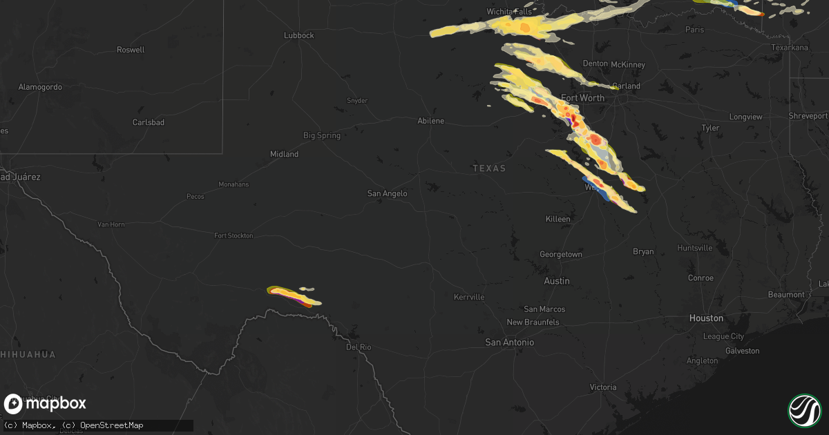
Hail Map in Texas on April 28, 2026
Get this storm
April 28 map
$229
one time, instant access
Download today. No call, no setup
Keep the $229
Bought the map and want the full workflow? Apply the entire $229 to a subscription within 7 days. None of it is wasted.
Every map, not just this one
This buys you this map. Subscription and you get every map we run, in the markets you choose from a few cities to whole states to nationwide. Plus real-time alerts the moment a storm fires.
Contact data
Name, contact info, occupancy, even credit band for addresses in the footprint. You go from where it hit to who to call.
Become the source they trust
Unlimited branding weather history reports on demand. You already have the documented answer ready for the property owner, and you are the one who showed up with it.
Property data and RoofTrace estimates
Pull up any address you have got, its value and the exact code rules for that jurisdiction, straight from One Click Code. Then RoofTrace estimates the squares, pitch, and roof value, priced the way you price.
Storm reports in Texas
Texas
| Date | Description |
|---|---|
| 04/28/20266:57 PM CDT | Amateur radio operator reported 2 inch hail at cleburne high school. |
| 04/28/20266:50 PM CDT | Amateur radio operator reported baseball hail near us 67 and chisholm trail expressway. |
| 04/28/20266:50 PM CDT | Amateur radio operator reported 3 inch hail at the johnson county eoc in cleburne. |
| 04/28/20266:42 PM CDT | Report from mping. |
| 04/28/20266:40 PM CDT | Report from mping. |
| 04/28/20266:39 PM CDT | Noaa employee reported 3 inch hail between godley and cleburne. |
| 04/28/20266:39 PM CDT | Trained spotter reported 4.5 inch hail on 171 between cresson and godley. |
| 04/28/20266:37 PM CDT | Trained spotter submitted photos of measured 3.5 inch hail. |
| 04/28/20266:37 PM CDT | Report from mping. |
| 04/28/20266:33 PM CDT | Report from mping. |
| 04/28/20266:31 PM CDT | Report from mping. |
| 04/28/20266:29 PM CDT | 3 inch wind driven hail. Broken windows on homes. Gray fox court near godley. |
| 04/28/20266:28 PM CDT | Report from mping of 1 inch hail west southwest of burleson. |
| 04/28/20266:26 PM CDT | Report from mping of 1.25 inch hail southwest of benbrook. |
| 04/28/20266:26 PM CDT | Trained spotter reported baseball size hail near godley. |
| 04/28/20266:20 PM CDT | Report from mping of 2.75 inch hail in cresson. |
| 04/28/20266:20 PM CDT | Amateur radio operator reported golf ball hail in cresson. |
| 04/28/20266:18 PM CDT | Amateur radio operator reported a 65 mph wind gust between cresson and godley. Time estimated by radar. |
| 04/28/20266:08 PM CDT | Amateur radio operator reported 1 inch hail south of aledo on kelly rd at the trinity river crossing. |
| 04/28/20266:05 PM CDT | Storm chaser reported golf ball size hail 5 miles west southwest of annetta south. |
| 04/28/20266:02 PM CDT | Broadcast media reported 1.75 inch hail in annetta south. |
| 04/28/20265:52 PM CDT | Amateur radio operator reported 1 inch hail in tin top. |
| 04/28/20265:50 PM CDT | Amateur radio operator reports 1 inch hail near mile marker 403 on i-20 southwest of weatherford. |
| 04/28/20265:49 PM CDT | Emergency manager reported golf ball sized hail in brock. |
| 04/28/20265:43 PM CDT | Amateur radio operator reported 2 inch hail southwest of weatherford... Near dennis road and fm 1189. |
| 04/28/20265:41 PM CDT | Report from mping of 1.75 inch hail south of millsap. |
| 04/28/20265:41 PM CDT | Amateur radio operator reported a 2.75 inch hailstone in millsap. |
| 04/28/20265:31 PM CDT | Report from mping of 1.5 inch hail south of mineral wells. |
| 04/28/20265:26 PM CDT | Emergency manager reported multiple 1 inch hailstones around keller... Including rufe snow dr and bear creek pkwy... And 1709 and keller smithfield rd. |
| 04/28/20265:24 PM CDT | Amateur radio operator reported 2 inch hail southwest of kmwl. |
| 04/28/20265:15 PM CDT | Kmwl gusted to 59 mph. |
| 04/28/20265:08 PM CDT | Trained spotter reported a swath of tree damage near mineral wells highway and maddux road. |
| 04/28/20265:04 PM CDT | Trained spotter reported multiple homes and structures damaged on lee rd to the east of mineral wells. |
| 04/28/20265:03 PM CDT | Trained spotter reported snapped trees northeast of mineral wells. Video and pictures via x. |
| 04/28/20264:32 PM CDT | Report from mping of 1.25 inch hail near decatur. |
| 04/28/20264:24 PM CDT | Report of golf ball sized hail near paradise. From mping. |
| 04/28/20264:20 PM CDT | Report of 1.25 inch hail southeast of bridgeport from mping. |
| 04/28/20264:19 PM CDT | Report from mping of 1 inch hail in bridgeport. |
| 04/28/20264:07 PM CDT | Amateur radio reported golf ball sized hail in chico off of sherman st and davis st. |
| 04/28/20264:03 PM CDT | Emergency manager reported 2 inch hail south of bryson off of fm 1191 and flat rock road. Time estimated by radar. |
| 04/28/20263:57 PM CDT | Storm chaser reported golf ball sized hail east of jacksboro. Pictures shared on x. |
| 04/28/20263:55 PM CDT | Amateur radio operator reported golf ball sized hail 5 miles south of bryson on fm 1191. |
| 04/28/20263:47 PM CDT | Trained spotter reported half dollar sized hail northeast of graham near us 380 and cement mountain road. |
| 04/28/20263:45 PM CDT | Amateur radio operator relayed report of 1 inch hail 5 miles south of bryson. |
| 04/28/20263:43 PM CDT | Report of 1 inch hail from mping. |
| 04/28/20263:10 PM CDT | Trained spotter reported quarter size hail 3 miles southwest of bowie. Time estimated by radar. |
| 04/28/20262:49 PM CDT | A local report indicates a tornado near Vashti |
| 04/28/20262:32 PM CDT | Report from mping: golf ball |
| 04/28/20262:20 PM CDT | Report from mping: golf ball |
| 04/28/20262:19 PM CDT | A local report indicates 1.75 inch wind near 4 SW Bluegrove |
| 04/28/20262:18 PM CDT | Along highway 172 east of scotland in clay county. |
| 04/28/20262:03 PM CDT | Also reported large tree limb downed. |
| 04/28/20261:33 PM CDT | Report from mping: golf ball |
| 04/28/20261:28 PM CDT | Report from mping: quarter |
| 04/28/202610:01 AM CDT | Delayed report. Tree damage was reported at a home near dexter. Many tree limbs were down or snapped and a large limb fell on top of the house. Time estimated by radar. |
| 04/28/20269:15 AM CDT | Multiple trees and power lines down just north of saint jo... And roadways had to be cleared. |
| 04/27/202610:55 PM CDT | Delayed report from tuesday night april 28th. Numerous social media photos showed hail from golfball to baseball size fell in hallsburg. Significant damage occurred to |
| 04/27/202610:50 PM CDT | 2.25 inch diameter hail reported near tradinghouse lake. |
| 04/27/202610:43 PM CDT | Report from mping: tennis ball 2.50 in. |
| 04/27/202610:40 PM CDT | Report from mping ping pong ball 1.50 in. |
| 04/27/202610:35 PM CDT | Report from mping quarter 1.00 in. |
| 04/27/202610:35 PM CDT | Quarter sized hail was reported in elm mott. |
| 04/27/202610:34 PM CDT | Report from mping quarter 1.00 in. |
| 04/27/202610:30 PM CDT | Golf ball sized hail was measured 7 miles south of mexia. |
| 04/27/202610:30 PM CDT | A 72 mph wind gust was measured at waco regional airport. |
| 04/27/202610:29 PM CDT | Report from mping ping pong ball. |
| 04/27/202610:23 PM CDT | Golf ball sized hail was reported in groesbeck. |
| 04/27/202610:20 PM CDT | Report from mping ping pong ball sized hail in groesbeck. |
| 04/27/202610:15 PM CDT | Report from mping half dollar sized hail 4 miles north of groesbeck. |
| 04/27/202610:12 PM CDT | Quarter sized hail was reported in groesbeck. |
| 04/27/20269:04 PM CDT | 3 inch hail on cottonwood near north czech hall road. |
| 04/27/20269:00 PM CDT | Baseball size hail between west and penelope via social media report. |
| 04/27/20268:56 PM CDT | 1 inch hail from public phone call in abbott. |
| 04/27/20268:47 PM CDT | Spotter reports 1.25 inch hail near abbott. |
| 04/27/20267:57 PM CDT | Report from mping. |
| 04/27/20267:53 PM CDT | Photo of measured 3.25 inch hail. Time estimated. |
| 04/27/20267:51 PM CDT | Report from mping. |
| 04/27/20267:27 PM CDT | Report from mping. |
| 04/27/20267:14 PM CDT | Amateur radio operator reported 2 inch hail 5 miles west southwest of grandview. |
All States Impacted by Hail Map on April 28, 2026
Cities Impacted by Hail Map on April 28, 2026
- Seymour, TX
- Prairie, MS
- Vardaman, MS
- Houston, MS
- Aberdeen, MS
- Munday, TX
- Holliday, TX
- Pittsboro, MS
- Calhoun City, MS
- Big Creek, MS
- Derma, MS
- Scotland, TX
- Wichita Falls, TX
- Henrietta, TX
- Windthorst, TX
- Bellevue, TX
- Ringgold, TX
- Bowie, TX
- Woodland, MS
- Nocona, TX
- Montague, TX
- Healdton, OK
- Duck Hill, MS
- Saint Jo, TX
- Muenster, TX
- Leon, OK
- Burneyville, OK
- Sulphur, OK
- Davis, OK
- Eupora, MS
- Stewart, MS
- Walthall, MS
- Gainesville, TX
- Grenada, MS
- Holcomb, MS
- Proctor, OK
- Purcell, OK
- Washington, OK
- Carrollton, MS
- McCarley, MS
- Springer, OK
- Graham, OK
- Ratliff City, OK
- Hamilton, MS
- Wynnewood, OK
- Okolona, MS
- Colcord, OK
- Rose, OK
- Kansas, OK
- Jay, OK
- Watts, OK
- Siloam Springs, AR
- Norman, OK
- Mathiston, MS
- Westville, OK
- Roff, OK
- Thackerville, OK
- Whitesboro, TX
- Marietta, OK
- Mcloud, OK
- Newalla, OK
- Shawnee, OK
- Tecumseh, OK
- Columbus, MS
- Tahlequah, OK
- Hulbert, OK
- Gentry, AR
- Gordonville, TX
- Lebanon, OK
- Kingston, OK
- Vaiden, MS
- Kilmichael, MS
- Starkville, MS
- Oaks, OK
- Mantee, MS
- Gattman, MS
- Greenwood Springs, MS
- Caledonia, MS
- Springdale, AR
- Meeker, OK
- Bentonville, AR
- Sulligent, AL
- Noble, OK
- Canehill, AR
- Lincoln, AR
- Vernon, AL
- Pottsboro, TX
- Fayetteville, AR
- Mead, OK
- Lowell, AR
- Weir, MS
- McCool, MS
- Cave Springs, AR
- Rogers, AR
- Ackerman, MS
- Fayette, AL
- Kennedy, AL
- Millport, AL
- Prairie Grove, AR
- Durant, OK
- Cartwright, OK
- Calera, OK
- Pea Ridge, AR
- Centerton, AR
- Pineville, MO
- Noel, MO
- Decatur, AR
- Rocky Comfort, MO
- Cassville, MO
- Powell, MO
- Washburn, MO
- Exeter, MO
- Elkins, AR
- Gravette, AR
- Hamilton, AL
- Beaverton, AL
- Detroit, AL
- Garfield, AR
- Seligman, MO
- Bella Vista, AR
- Farmington, AR
- West Fork, AR
- Louisville, MS
- Caddo, OK
- Sturgis, MS
- Alexander City, AL
- Amory, MS
- Smithville, MS
- French Camp, MS
- Wesley, AR
- Huntsville, AR
- Hindsville, AR
- Purdy, MO
- Aurora, MO
- Crane, MO
- Wheaton, MO
- Monett, MO
- Butterfield, MO
- Verona, MO
- Bokchito, OK
- Guin, AL
- Billings, MO
- Marionville, MO
- Brilliant, AL
- Eagle Rock, MO
- Smithville, OK
- Honobia, OK
- Haleyville, AL
- Galena, MO
- Clever, MO
- Republic, MO
- Brookline, MO
- Springfield, MO
- Bois D Arc, MO
- Kingston, AR
- Coffeyville, KS
- Edna, KS
- McCalla, AL
- Jerico Springs, MO
- Oswego, KS
- Chetopa, KS
- Stockton, MO
- El Dorado Springs, MO
- Bartlett, KS
- Willard, MO
- Compton, AR
- Berryville, AR
- Ponca, AR
- Green Forest, AR
- Rogersville, MO
- Pleasant Hope, MO
- Strafford, MO
- Fair Grove, MO
- Brighton, MO
- Noxapater, MS
- Philadelphia, MS
- Wagoner, OK
- Liberal, MO
- Montrose, MO
- Urich, MO
- Columbus, KS
- Nixa, MO
- Pawnee, OK
- Hominy, OK
- Fairfax, OK
- Lamar, MO
- Sheldon, MO
- West Point, MS
- Adair, OK
- Marshfield, MO
- Buffalo, MO
- Elkland, MO
- Long Lane, MO
- Conway, MO
- Jasper, AR
- Alpena, AR
- Phillipsburg, MO
- Marble Falls, AR
- Vendor, AR
- Hasty, AR
- Harrison, AR
- Bartlesville, OK
- Dewey, OK
- Delaware, OK
- Louisburg, MO
- Hermitage, MO
- Urbana, MO
- Mansfield, MO
- Norwood, MO
- Macomb, MO
- Windyville, MO
- Lebanon, MO
- Wann, OK
- Lenapah, OK
- Tunas, MO
- Eldridge, MO
- Barnsdall, OK
- Pawhuska, OK
- Ochelata, OK
- Clinton, MO
- Calhoun, MO
- Leeton, MO
- Chilhowee, MO
- S Coffeyville, OK
- Afton, OK
- Wyandotte, OK
- Grove, OK
- Fairland, OK
- Mountain Grove, MO
- Everton, AR
- Western Grove, AR
- Saint Joe, AR
- Pindall, AR
- Big Cabin, OK
- Mena, AR
- Wynona, OK
- Spavinaw, OK
- Farmerville, LA
- Downsville, LA
- Little Rock, MS
- Grovespring, MO
- Ozark, MO
- Niangua, MO
- Broken Bow, OK
- Ethelsville, AL
- Nashville, AR
- Mineral Springs, AR
- Horatio, AR
- Lockesburg, AR
- Polk, MO
- Pittsburg, MO
- Weir, KS
- Scammon, KS
- Bolivar, MO
- Half Way, MO
- Webb City, MO
- Alba, MO
- Asbury, MO
- Jasper, MO
- Carl Junction, MO
- Pittsburg, KS
- Galena, KS
- Oronogo, MO
- Purcell, MO
- Muldrow, OK
- Duenweg, MO
- Diamond, MO
- Joplin, MO
- Carthage, MO
- Humansville, MO
- Fort Gibson, OK
- Vinita, OK
- Stoutland, MO
- Montreal, MO
- Decatur, MS
- Scranton, AR
- Ava, MO
- Foreman, AR
- Winthrop, AR
- Steens, MS
- Eucha, OK
- Sallisaw, OK
- Emelle, AL
- Drury, MO
- Squires, MO
- Arkadelphia, AR
- Bailey, MS
- Meridian, MS
- Murfreesboro, AR
- New Blaine, AR
- Sulphur Springs, AR
- Anderson, MO
- Lamar, AR
- Carthage, MS
- Walnut Grove, MS
- Reeds, MO
- Marion, LA
- Chunky, MS
- Collinsville, MS
- Fair Play, MO
- Conehatta, MS
- Union, MS
- Copan, OK
- Dierks, AR
- Vanzant, MO
- Richland, MO
- Gilbert, AR
- Marshall, AR
- Twin Oaks, OK
- Delight, AR
- Okolona, AR
- Liberty, KS
- Harriet, AR
- Tiff City, MO
- South West City, MO
- Goodman, MO
- Frontenac, KS
- Cherokee, KS
- West Monroe, LA
- Stotts City, MO
- Wentworth, MO
- Sarcoxie, MO
- Sterlington, LA
- Malvern, AR
- Arma, KS
- Miller, MO
- London, AR
- Dover, AR
- Everton, MO
- West Mineral, KS
- McCune, KS
- Monroe, LA
- La Russell, MO
- Ash Grove, MO
- Halltown, MO
- Marion, MS
- Parsons, KS
- Dennis, KS
- Mound Valley, KS
- Welch, OK
- Mount Vernon, MO
- Bismarck, AR
- Walnut Grove, MO
- Collinston, LA
- Bastrop, LA
- Altamont, KS
- Pierce City, MO
- Donaldson, AR
- Valley Springs, AR
- Freistatt, MO
- Iberia, MO
- Saint Elizabeth, MO
- Avilla, MO
- Agra, OK
- Ripley, OK
- Poyen, AR
- Flippin, AR
- Big Flat, AR
- Fifty Six, AR
- Saint Paul, KS
- Mindenmines, MO
- Bronaugh, MO
- Mulberry, KS
- Pauls Valley, OK
- Nevada, MO
- Girard, KS
- Timbo, AR
- Mountain View, AR
- Stark City, MO
- Stella, MO
- Ward, AR
- Yale, OK
- Jennings, OK
- Drumright, OK
- Cushing, OK
- Mannford, OK
- Tryon, OK
- Beebe, AR
- Rayville, LA
- Sparta, MO
- Highlandville, MO
- Petrolia, TX
- Oak Ridge, LA
- Mer Rouge, LA
- Austin, AR
- Hennepin, OK
- Jerusalem, AR
- Atkins, AR
- Hattieville, AR
- Elmore City, OK
- Leslie, AR
- Onia, AR
- Waurika, OK
- Sand Springs, OK
- Lincoln, MO
- Stover, MO
- Fairview, MO
- Neosho, MO
- Warsaw, MO
- Edwards, MO
- Meta, MO
- Vilonia, AR
- Conway, AR
- Jacksonville, AR
- El Paso, AR
- Duncan, OK
- Pioneer, LA
- Delhi, LA
- Lake Providence, LA
- Sondheimer, LA
- Epps, LA
- Gravois Mills, MO
- Rocky Mount, MO
- Ringling, OK
- Moundville, MO
- Carterville, MO
- Versailles, MO
- Shell Knob, MO
- Stratford, OK
- Stroud, OK
- Des Arc, AR
- Archer City, TX
- Tulsa, OK
- Skiatook, OK
- Forsyth, MO
- Arcadia, KS
- McRae, AR
- Searcy, AR
- Garner, AR
- Seymour, MO
- Milo, MO
- Sperry, OK
- Lonoke, AR
- Carlisle, AR
- Melbourne, AR
- Golden City, MO
- Collinsville, OK
- Gallion, AL
- Ada, OK
- Barnett, MO
- Pleasant Grove, AR
- Fordland, MO
- Griffithville, AR
- Cape Fair, MO
- Ryan, OK
- Hartville, MO
- Depew, OK
- Bristow, OK
- Tallulah, LA
- Oak Grove, LA
- Batesville, AR
- Marcella, AR
- Guion, AR
- Loco, OK
- Faunsdale, AL
- Cotton Plant, AR
- Eldon, MO
- Mill Creek, OK
- Konawa, OK
- Sulphur Rock, AR
- Cave City, AR
- Charlotte, AR
- Chelsea, OK
- Talala, OK
- Oologah, OK
- Owasso, OK
- Claremore, OK
- Fountain Hill, AR
- Sapulpa, OK
- Transylvania, LA
- Heber Springs, AR
- Tishomingo, OK
- Stonewall, OK
- Wilson, OK
- Sasakwa, OK
- Holdenville, OK
- Harrisburg, AR
- Jacksboro, TX
- Catoosa, OK
- Chadwick, MO
- Wynne, AR
- McCrory, AR
- Olney, TX
- Vicksburg, MS
- Dora, MO
- Gould, AR
- Grady, AR
- Jachin, AL
- Butler, AL
- Lisman, AL
- Wewoka, OK
- Lone Grove, OK
- Milburn, OK
- Wapanucka, OK
- Marked Tree, AR
- Overbrook, OK
- Ardmore, OK
- Hackleburg, AL
- Valley Park, MS
- Inola, OK
- Cherry Valley, AR
- Taneyville, MO
- Loving, TX
- Coleman, OK
- Tupelo, OK
- Wetumka, OK
- Heth, AR
- Willow Springs, MO
- West Plains, MO
- Pomona, MO
- De Witt, AR
- Tichnor, AR
- Ethel, AR
- Saint Charles, AR
- Lamar, OK
- Dustin, OK
- Stuttgart, AR
- Sunset, TX
- Bear Creek, AL
- Greenwood, MS
- Atoka, OK
- Graham, TX
- Newcastle, TX
- Eudora, AR
- Coalgate, OK
- Pottersville, MO
- Cabool, MO
- Peace Valley, MO
- Chouteau, OK
- Mountain View, MO
- Locust Grove, OK
- Bryson, TX
- Forestburg, TX
- Muskogee, OK
- Tyronza, AR
- Calvin, OK
- Caney, OK
- Kenefic, OK
- Cord, AR
- Newark, AR
- Elaine, AR
- Helena, AR
- Holly Grove, AR
- Mellwood, AR
- Lexa, AR
- Crumrod, AR
- Alligator, MS
- Snow Lake, AR
- Coahoma, MS
- Clarksdale, MS
- Friars Point, MS
- Duncan, MS
- Summersville, MO
- Gilmore, AR
- Bassett, AR
- Frenchmans Bayou, AR
- Joiner, AR
- Turrell, AR
- Lane, OK
- Birch Tree, MO
- Mcalester, OK
- Porter, OK
- Stuart, OK
- Coweta, OK
- Rolling Fork, MS
- Madill, OK
- Chico, TX
- Bridgeport, TX
- Dyess, AR
- Peggs, OK
- Kinta, OK
- Sweet Water, AL
- Drummonds, TN
- Steele, MO
- Dundee, MS
- Sledge, MS
- Tunica, MS
- Perrin, TX
- Alton, MO
- Winona, MO
- Fremont, MO
- Doniphan, MO
- Van Buren, MO
- Collierville, TN
- Antlers, OK
- Eads, TN
- Paradise, TX
- Decatur, TX
- Graford, TX
- Burlison, TN
- Millington, TN
- Brighton, TN
- Covington, TN
- Munford, TN
- Atoka, TN
- Gatewood, MO
- Alvord, TX
- Indianola, OK
- Byhalia, MS
- Red Banks, MS
- Keota, OK
- Mccurtain, OK
- Stigler, OK
- Breckenridge, TX
- South Bend, TX
- Yazoo City, MS
- Holly Bluff, MS
- Jackson, AL
- Gans, OK
- Quinton, OK
- Atwood, OK
- Haskell, OK
- Okmulgee, OK
- Redbird, OK
- Beggs, OK
- Holly Springs, MS
- Grandin, MO
- Summers, AR
- Henning, TN
- Soper, OK
- Hugo, OK
- Rhome, TX
- Boyd, TX
- Mineral Wells, TX
- Weatherford, TX
- Whitt, TX
- Bokoshe, OK
- Rattan, OK
- Spiro, OK
- Grove Hill, AL
- Wilburton, OK
- Couch, MO
- Fairdealing, MO
- Poplar Bluff, MO
- Oxly, MO
- Success, AR
- Maynard, AR
- Naylor, MO
- Neelyville, MO
- Harviell, MO
- Corning, AR
- Brownsville, TN
- Ripley, TN
- Benton, MS
- Red Oak, OK
- Poteau, OK
- Stilwell, OK
- Shady Point, OK
- Vaughan, MS
- Macks Creek, MO
- Clinton, KY
- Palo Pinto, TX
- Cameron, OK
- Haslet, TX
- Wister, OK
- Ellsinore, MO
- Spencerville, OK
- Moyers, OK
- Sawyer, OK
- Springtown, TX
- Fort Towson, OK
- Newark, TX
- Justin, TX
- Boaz, KY
- Hickory, KY
- Strawn, TX
- Hackett, AR
- Pocola, OK
- Boswell, OK
- Natural Dam, AR
- Chester, AR
- Winslow, AR
- East Prairie, MO
- Charleston, MO
- Pickens, MS
- Camdenton, MO
- Millsap, TX
- Qulin, MO
- Pollard, AR
- Piggott, AR
- Valliant, OK
- Garvin, OK
- Campbell, MO
- Saint Francis, AR
- Greenway, AR
- Southlake, TX
- Roanoke, TX
- Keller, TX
- Idabel, OK
- Wright City, OK
- Canton, MS
- Camden, MS
- Mountainburg, AR
- Symsonia, KY
- Fort Worth, TX
- Morrow, AR
- Welling, OK
- Grapevine, TX
- Colleyville, TX
- North Richland Hills, TX
- Lexington, MS
- Combs, AR
- Paducah, KY
- Howe, OK
- Fort Smith, AR
- Aledo, TX
- Ozark, AR
- Saint Paul, AR
- Kosciusko, MS
- Holcomb, MO
- Clarkton, MO
- Gideon, MO
- Gordon, TX
- Rector, AR
- Caddo, TX
- Sallis, MS
- Heavener, OK
- Dryden, TX
- Pettigrew, AR
- Witter, AR
- Durant, MS
- Goodman, MS
- Irving, TX
- Dallas, TX
- Gibson, MO
- Wardell, MO
- Mayfield, KY
- Malden, MO
- Broseley, MO
- Haworth, OK
- Cresson, TX
- Granbury, TX
- Santo, TX
- Bells, TN
- Alamo, TN
- Stanton, TN
- Whiteville, TN
- Denmark, TN
- Mercer, TN
- Oark, AR
- Eagletown, OK
- Hector, AR
- Russellville, AR
- Deer, AR
- Lena, MS
- Bentonia, MS
- Godley, TX
- Crowley, TX
- Burleson, TX
- Joshua, TX
- Clarksville, AR
- Cruger, MS
- Comstock, TX
- Memphis, TN
- De Queen, AR
- Keene, TX
- Cleburne, TX
- West, MS
- Coila, MS
- Lipan, TX
- Ethel, MS
- Toomsuba, MS
- Hagarville, AR
- Ozone, AR
- Earle, AR
- Pelsor, AR
- Alvarado, TX
- Witts Springs, AR
- Plainview, AR
- Sherwood, AR
- Little Rock Air Force Base, AR
- Gravelly, AR
- Harvey, AR
- Grandview, TX
- Rio Vista, TX
- Covington, TX
- Itasca, TX
- Drasco, AR
- Ozan, AR
- Clinton, AR
- Scotland, AR
- Cleveland, AR
- Center Ridge, AR
- Cabot, AR
- Bluffton, AR
- Tilly, AR
- Bee Branch, AR
- Quitman, MS
- Gurdon, AR
- Prescott, AR
- Milford, TX
- Damascus, AR
- Hillsboro, TX
- Blum, TX
- Georgiana, AL
- Wilburn, AR
- Tumbling Shoals, AR
- Chidester, AR
- Macon, MS
- Shuqualak, MS
- Whitney, TX
- Abbott, TX
- Mertens, TX
- Bynum, TX
- Brinkley, AR
- Clarendon, AR
- Hermitage, AR
- Wilmar, AR
- Bearden, AR
- Camden, AR
- Penelope, TX
- Malone, TX
- Sparkman, AR
- Iredell, TX
- Bluff City, AR
- Forrest City, AR
- Italy, TX
- Walnut Springs, TX
- Colt, AR
- Hamburg, AR
- Monticello, AR
- Frost, TX
- Mount Calm, TX
- West, TX
- Meridian, TX
- Morgan, TX
- Thornton, AR
- Hampton, AR
- Warren, AR
- Banks, AR
- Winona, MS
- Widener, AR
- Hubbard, TX
- Fordyce, AR
- Sidon, MS
- Elizabethtown, KY
- Dawson, TX
- Coolidge, TX
- Axtell, TX
- Clifton, TX
- Batesville, MS
- Sardis, MS
- Montrose, AR
- Dermott, AR
- Madison, AR
- Marianna, AR
- Palestine, AR
- Prairie Hill, TX
- Groesbeck, TX
- Aquilla, TX
- Valley Mills, TX
- Lake Village, AR
- Mexia, TX
- Hughes, AR
- China Spring, TX
- Waco, TX
- Portland, AR
- Elm Mott, TX
- Leland, MS
- Greenville, MS
- Riesel, TX
- Mart, TX
- Houlka, MS
- Carthage, AR
- Marlin, TX
- Sherrill, AR
- White Hall, AR
- Kosse, TX
- Thornton, TX
- Kingsland, AR
- Rison, AR
- Tremont, MS
- Altheimer, AR
- Pine Bluff, AR
- Indianola, MS
- Inverness, MS
- Hollandale, MS
- Isola, MS
- Belzoni, MS
- Itta Bena, MS
- Tchula, MS
- Star City, AR
- Reagan, TX
- Bremond, TX
- Franklin, TX
- Gillett, AR
- Reform, AL
- Gordo, AL
- Enid, MS
- Courtland, MS
- Oakland, MS
- Pope, MS
- Scobey, MS
- Gunnison, MS
- Marietta, MS
- Booneville, MS
- Baldwyn, MS
- Golden, MS
- Fulton, MS
- New Site, MS
- Dennis, MS
- Belmont, MS
- Como, MS
- Marks, MS
- Water Valley, MS
- Red Bay, AL
- Hodges, AL
- Oxford, MS
- Abbeville, MS
- Crenshaw, MS
- Russellville, AL
- New Edinburg, AR
- Vina, AL
- Spruce Pine, AL
- Phil Campbell, AL
- Taylor, MS
- Mount Hope, AL
- Mayersville, MS
- Flora, MS
- Satartia, MS
- Etta, MS
- New Albany, MS
- Myrtle, MS
- Hickory Flat, MS
- Thaxton, MS
- Potts Camp, MS
- Mantachie, MS
- Blue Mountain, MS
- Redwood, MS
- Dumas, MS
- Madison, MS
- Blue Springs, MS
- Guntown, MS
- Senatobia, MS
- Coldwater, MS
- Tuscumbia, AL
- Cherokee, AL
- Falcon, MO
- Linn Creek, MO


