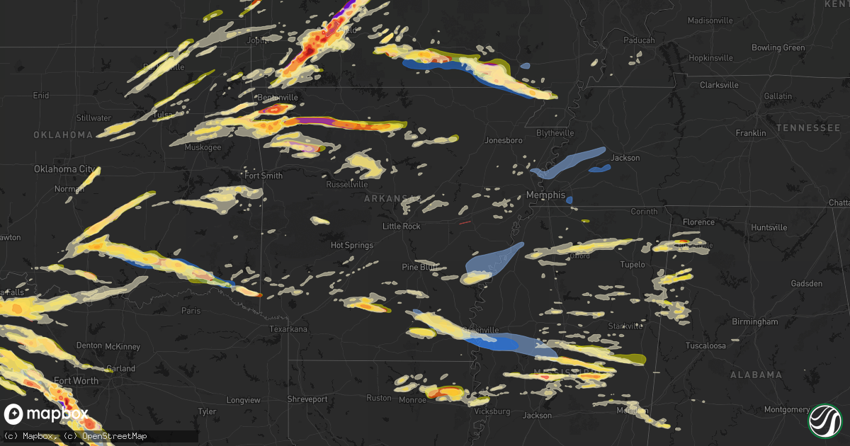
Hail Map in Arkansas on April 28, 2026
Get this storm
April 28 map
$229
one time, instant access
Download today. No call, no setup
Keep the $229
Bought the map and want the full workflow? Apply the entire $229 to a subscription within 7 days. None of it is wasted.
Every map, not just this one
This buys you this map. Subscription and you get every map we run, in the markets you choose from a few cities to whole states to nationwide. Plus real-time alerts the moment a storm fires.
Contact data
Name, contact info, occupancy, even credit band for addresses in the footprint. You go from where it hit to who to call.
Become the source they trust
Unlimited branding weather history reports on demand. You already have the documented answer ready for the property owner, and you are the one who showed up with it.
Property data and RoofTrace estimates
Pull up any address you have got, its value and the exact code rules for that jurisdiction, straight from One Click Code. Then RoofTrace estimates the squares, pitch, and roof value, priced the way you price.
Storm reports in Arkansas
Arkansas
| Date | Description |
|---|---|
| 04/28/20266:58 PM CDT | Tree down across buck range road... Blocking traffic. |
| 04/28/20266:46 PM CDT | This is a delayed report. Pictures via social media shows some trees down along hwy 7. |
| 04/28/20266:45 PM CDT | Very large tree branch snapped and fell on an outbuilding on yorks chapel road. Also... Down trees reported on nearby cornbridge road. |
| 04/28/20266:34 PM CDT | 911 dispatch received reports of multiple trees down across the county... Some of which were located along hwy 371 near lockesburg and on elm drive in lockesburg. |
| 04/28/20265:34 PM CDT | A local report indicates 1.50 inch wind near Piggott |
| 04/28/20265:30 PM CDT | A local report indicates 1.75 inch wind near Corning |
| 04/28/20265:30 PM CDT | A local report indicates 1.00 inch wind near Hackett |
| 04/28/20265:14 PM CDT | A local report indicates 1.00 inch wind near Greenland |
| 04/28/20265:04 PM CDT | A local report indicates 1.75 inch wind near Walnut Grove |
| 04/28/20265:02 PM CDT | A local report indicates 1.75 inch wind near Farmington |
| 04/28/20264:57 PM CDT | A local report indicates 1.25 inch wind near 1 NE Lincoln |
| 04/28/20264:54 PM CDT | Report from mping: half dollar |
| 04/28/20264:54 PM CDT | A local report indicates 1.75 inch wind near Lincoln |
| 04/28/20262:20 PM CDT | A report of a tree fell through a mobile home in the jacksonville area. |
| 04/28/20262:15 PM CDT | A few trees were knocked down in this area. |
| 04/28/202612:34 PM CDT | 2 inch size hail. |
| 04/28/202612:24 PM CDT | Hen egg size hail at the school in jasper. |
| 04/28/202611:56 AM CDT | A local report indicates 1.00 inch wind near 3 W Stoverville |
| 04/28/202611:14 AM CDT | A local report indicates 1.50 inch wind near 4 E Fayetteville |
| 04/28/202611:10 AM CDT | Photo relayed by broadcast media. Hail pictured next to a tape measure. Time estimated by radar. |
| 04/28/202610:50 AM CDT | Report from mping: hen egg |
| 04/28/202610:47 AM CDT | Report from mping: quarter |
| 04/28/202610:46 AM CDT | A local report indicates 2.25 inch wind near 1 NE Elm Springs |
| 04/28/202610:44 AM CDT | A local report indicates 2.00 inch wind near 2 S Cave Springs |
| 04/28/202610:43 AM CDT | A local report indicates 1.75 inch wind near 2 S Cave Springs |
| 04/28/202610:42 AM CDT | A local report indicates 1.50 inch wind near 2 W Lowell |
| 04/28/202610:40 AM CDT | Photo of hail next to a tape measure sent via social media. Time estimated by radar. |
| 04/28/202610:34 AM CDT | Report from mping: quarter |
| 04/28/202610:33 AM CDT | Report from mping: quarter |
| 04/28/202610:33 AM CDT | A local report indicates 2.75 inch wind near 3 NE Tontitown |
| 04/28/202610:30 AM CDT | A local report indicates 2.00 inch wind near 2 N Cave Springs |
| 04/28/202610:25 AM CDT | Photo shared by broadcast media. Time estimated via radar. |
| 04/28/202610:07 AM CDT | Report from mping: quarter |
| 04/27/20269:59 PM CDT | Multiple trees fell on a house and two vehicles at a residence along lakeshore dr. |
| 04/27/20269:59 PM CDT | Measured at a private davis weather station at the lake village municipal airport. |
| 04/27/20269:58 PM CDT | Carport damaged and blown across the road at us 65 and sixteenth section rd. |
| 04/27/20269:58 PM CDT | A flagpole was bent to the ground at ar 144 and club dr. |
| 04/27/20269:58 PM CDT | Power lines down across lakeside st. Large tree uprooted and fallen across power lines along mulberry st. |
| 04/27/20269:55 PM CDT | Sheds were damaged and a trailer was blown on its side along airport rd. |
| 04/27/20269:35 PM CDT | *** 1 inj *** a tree fell on a home in dermott... Resulting in minor injuries to one resident. |
| 04/27/20269:35 PM CDT | Couple trees down. |
| 04/27/20268:54 PM CDT | Trees and powerlines reported down across ar-highway 8 north of warren. |
| 04/27/20268:45 PM CDT | Tree down across hwy 425. |
| 04/27/20268:37 PM CDT | Tree and lines down along hwy 133... Possible tornado. |
| 04/27/20268:25 PM CDT | A local report indicates 2.00 inch wind near Amy |
| 04/27/20267:51 PM CDT | A tornado was observed and photographed at this approximate location. The observer was sw of brinkley... Looking south. |
| 04/27/20267:15 PM CDT | 911 call center received a report of trees down on hwy 29 near the town of blevins. |
All States Impacted by Hail Map on April 28, 2026
Cities Impacted by Hail Map on April 28, 2026
- Seymour, TX
- Prairie, MS
- Vardaman, MS
- Houston, MS
- Aberdeen, MS
- Munday, TX
- Holliday, TX
- Pittsboro, MS
- Calhoun City, MS
- Big Creek, MS
- Derma, MS
- Scotland, TX
- Wichita Falls, TX
- Henrietta, TX
- Windthorst, TX
- Bellevue, TX
- Ringgold, TX
- Bowie, TX
- Woodland, MS
- Nocona, TX
- Montague, TX
- Healdton, OK
- Duck Hill, MS
- Saint Jo, TX
- Muenster, TX
- Leon, OK
- Burneyville, OK
- Sulphur, OK
- Davis, OK
- Eupora, MS
- Stewart, MS
- Walthall, MS
- Gainesville, TX
- Grenada, MS
- Holcomb, MS
- Proctor, OK
- Purcell, OK
- Washington, OK
- Carrollton, MS
- McCarley, MS
- Springer, OK
- Graham, OK
- Ratliff City, OK
- Hamilton, MS
- Wynnewood, OK
- Okolona, MS
- Colcord, OK
- Rose, OK
- Kansas, OK
- Jay, OK
- Watts, OK
- Siloam Springs, AR
- Norman, OK
- Mathiston, MS
- Westville, OK
- Roff, OK
- Thackerville, OK
- Whitesboro, TX
- Marietta, OK
- Mcloud, OK
- Newalla, OK
- Shawnee, OK
- Tecumseh, OK
- Columbus, MS
- Tahlequah, OK
- Hulbert, OK
- Gentry, AR
- Gordonville, TX
- Lebanon, OK
- Kingston, OK
- Vaiden, MS
- Kilmichael, MS
- Starkville, MS
- Oaks, OK
- Mantee, MS
- Gattman, MS
- Greenwood Springs, MS
- Caledonia, MS
- Springdale, AR
- Meeker, OK
- Bentonville, AR
- Sulligent, AL
- Noble, OK
- Canehill, AR
- Lincoln, AR
- Vernon, AL
- Pottsboro, TX
- Fayetteville, AR
- Mead, OK
- Lowell, AR
- Weir, MS
- McCool, MS
- Cave Springs, AR
- Rogers, AR
- Ackerman, MS
- Fayette, AL
- Kennedy, AL
- Millport, AL
- Prairie Grove, AR
- Durant, OK
- Cartwright, OK
- Calera, OK
- Pea Ridge, AR
- Centerton, AR
- Pineville, MO
- Noel, MO
- Decatur, AR
- Rocky Comfort, MO
- Cassville, MO
- Powell, MO
- Washburn, MO
- Exeter, MO
- Elkins, AR
- Gravette, AR
- Hamilton, AL
- Beaverton, AL
- Detroit, AL
- Garfield, AR
- Seligman, MO
- Bella Vista, AR
- Farmington, AR
- West Fork, AR
- Louisville, MS
- Caddo, OK
- Sturgis, MS
- Alexander City, AL
- Amory, MS
- Smithville, MS
- French Camp, MS
- Wesley, AR
- Huntsville, AR
- Hindsville, AR
- Purdy, MO
- Aurora, MO
- Crane, MO
- Wheaton, MO
- Monett, MO
- Butterfield, MO
- Verona, MO
- Bokchito, OK
- Guin, AL
- Billings, MO
- Marionville, MO
- Brilliant, AL
- Eagle Rock, MO
- Smithville, OK
- Honobia, OK
- Haleyville, AL
- Galena, MO
- Clever, MO
- Republic, MO
- Brookline, MO
- Springfield, MO
- Bois D Arc, MO
- Kingston, AR
- Coffeyville, KS
- Edna, KS
- McCalla, AL
- Jerico Springs, MO
- Oswego, KS
- Chetopa, KS
- Stockton, MO
- El Dorado Springs, MO
- Bartlett, KS
- Willard, MO
- Compton, AR
- Berryville, AR
- Ponca, AR
- Green Forest, AR
- Rogersville, MO
- Pleasant Hope, MO
- Strafford, MO
- Fair Grove, MO
- Brighton, MO
- Noxapater, MS
- Philadelphia, MS
- Wagoner, OK
- Liberal, MO
- Montrose, MO
- Urich, MO
- Columbus, KS
- Nixa, MO
- Pawnee, OK
- Hominy, OK
- Fairfax, OK
- Lamar, MO
- Sheldon, MO
- West Point, MS
- Adair, OK
- Marshfield, MO
- Buffalo, MO
- Elkland, MO
- Long Lane, MO
- Conway, MO
- Jasper, AR
- Alpena, AR
- Phillipsburg, MO
- Marble Falls, AR
- Vendor, AR
- Hasty, AR
- Harrison, AR
- Bartlesville, OK
- Dewey, OK
- Delaware, OK
- Louisburg, MO
- Hermitage, MO
- Urbana, MO
- Mansfield, MO
- Norwood, MO
- Macomb, MO
- Windyville, MO
- Lebanon, MO
- Wann, OK
- Lenapah, OK
- Tunas, MO
- Eldridge, MO
- Barnsdall, OK
- Pawhuska, OK
- Ochelata, OK
- Clinton, MO
- Calhoun, MO
- Leeton, MO
- Chilhowee, MO
- S Coffeyville, OK
- Afton, OK
- Wyandotte, OK
- Grove, OK
- Fairland, OK
- Mountain Grove, MO
- Everton, AR
- Western Grove, AR
- Saint Joe, AR
- Pindall, AR
- Big Cabin, OK
- Mena, AR
- Wynona, OK
- Spavinaw, OK
- Farmerville, LA
- Downsville, LA
- Little Rock, MS
- Grovespring, MO
- Ozark, MO
- Niangua, MO
- Broken Bow, OK
- Ethelsville, AL
- Nashville, AR
- Mineral Springs, AR
- Horatio, AR
- Lockesburg, AR
- Polk, MO
- Pittsburg, MO
- Weir, KS
- Scammon, KS
- Bolivar, MO
- Half Way, MO
- Webb City, MO
- Alba, MO
- Asbury, MO
- Jasper, MO
- Carl Junction, MO
- Pittsburg, KS
- Galena, KS
- Oronogo, MO
- Purcell, MO
- Muldrow, OK
- Duenweg, MO
- Diamond, MO
- Joplin, MO
- Carthage, MO
- Humansville, MO
- Fort Gibson, OK
- Vinita, OK
- Stoutland, MO
- Montreal, MO
- Decatur, MS
- Scranton, AR
- Ava, MO
- Foreman, AR
- Winthrop, AR
- Steens, MS
- Eucha, OK
- Sallisaw, OK
- Emelle, AL
- Drury, MO
- Squires, MO
- Arkadelphia, AR
- Bailey, MS
- Meridian, MS
- Murfreesboro, AR
- New Blaine, AR
- Sulphur Springs, AR
- Anderson, MO
- Lamar, AR
- Carthage, MS
- Walnut Grove, MS
- Reeds, MO
- Marion, LA
- Chunky, MS
- Collinsville, MS
- Fair Play, MO
- Conehatta, MS
- Union, MS
- Copan, OK
- Dierks, AR
- Vanzant, MO
- Richland, MO
- Gilbert, AR
- Marshall, AR
- Twin Oaks, OK
- Delight, AR
- Okolona, AR
- Liberty, KS
- Harriet, AR
- Tiff City, MO
- South West City, MO
- Goodman, MO
- Frontenac, KS
- Cherokee, KS
- West Monroe, LA
- Stotts City, MO
- Wentworth, MO
- Sarcoxie, MO
- Sterlington, LA
- Malvern, AR
- Arma, KS
- Miller, MO
- London, AR
- Dover, AR
- Everton, MO
- West Mineral, KS
- McCune, KS
- Monroe, LA
- La Russell, MO
- Ash Grove, MO
- Halltown, MO
- Marion, MS
- Parsons, KS
- Dennis, KS
- Mound Valley, KS
- Welch, OK
- Mount Vernon, MO
- Bismarck, AR
- Walnut Grove, MO
- Collinston, LA
- Bastrop, LA
- Altamont, KS
- Pierce City, MO
- Donaldson, AR
- Valley Springs, AR
- Freistatt, MO
- Iberia, MO
- Saint Elizabeth, MO
- Avilla, MO
- Agra, OK
- Ripley, OK
- Poyen, AR
- Flippin, AR
- Big Flat, AR
- Fifty Six, AR
- Saint Paul, KS
- Mindenmines, MO
- Bronaugh, MO
- Mulberry, KS
- Pauls Valley, OK
- Nevada, MO
- Girard, KS
- Timbo, AR
- Mountain View, AR
- Stark City, MO
- Stella, MO
- Ward, AR
- Yale, OK
- Jennings, OK
- Drumright, OK
- Cushing, OK
- Mannford, OK
- Tryon, OK
- Beebe, AR
- Rayville, LA
- Sparta, MO
- Highlandville, MO
- Petrolia, TX
- Oak Ridge, LA
- Mer Rouge, LA
- Austin, AR
- Hennepin, OK
- Jerusalem, AR
- Atkins, AR
- Hattieville, AR
- Elmore City, OK
- Leslie, AR
- Onia, AR
- Waurika, OK
- Sand Springs, OK
- Lincoln, MO
- Stover, MO
- Fairview, MO
- Neosho, MO
- Warsaw, MO
- Edwards, MO
- Meta, MO
- Vilonia, AR
- Conway, AR
- Jacksonville, AR
- El Paso, AR
- Duncan, OK
- Pioneer, LA
- Delhi, LA
- Lake Providence, LA
- Sondheimer, LA
- Epps, LA
- Gravois Mills, MO
- Rocky Mount, MO
- Ringling, OK
- Moundville, MO
- Carterville, MO
- Versailles, MO
- Shell Knob, MO
- Stratford, OK
- Stroud, OK
- Des Arc, AR
- Archer City, TX
- Tulsa, OK
- Skiatook, OK
- Forsyth, MO
- Arcadia, KS
- McRae, AR
- Searcy, AR
- Garner, AR
- Seymour, MO
- Milo, MO
- Sperry, OK
- Lonoke, AR
- Carlisle, AR
- Melbourne, AR
- Golden City, MO
- Collinsville, OK
- Gallion, AL
- Ada, OK
- Barnett, MO
- Pleasant Grove, AR
- Fordland, MO
- Griffithville, AR
- Cape Fair, MO
- Ryan, OK
- Hartville, MO
- Depew, OK
- Bristow, OK
- Tallulah, LA
- Oak Grove, LA
- Batesville, AR
- Marcella, AR
- Guion, AR
- Loco, OK
- Faunsdale, AL
- Cotton Plant, AR
- Eldon, MO
- Mill Creek, OK
- Konawa, OK
- Sulphur Rock, AR
- Cave City, AR
- Charlotte, AR
- Chelsea, OK
- Talala, OK
- Oologah, OK
- Owasso, OK
- Claremore, OK
- Fountain Hill, AR
- Sapulpa, OK
- Transylvania, LA
- Heber Springs, AR
- Tishomingo, OK
- Stonewall, OK
- Wilson, OK
- Sasakwa, OK
- Holdenville, OK
- Harrisburg, AR
- Jacksboro, TX
- Catoosa, OK
- Chadwick, MO
- Wynne, AR
- McCrory, AR
- Olney, TX
- Vicksburg, MS
- Dora, MO
- Gould, AR
- Grady, AR
- Jachin, AL
- Butler, AL
- Lisman, AL
- Wewoka, OK
- Lone Grove, OK
- Milburn, OK
- Wapanucka, OK
- Marked Tree, AR
- Overbrook, OK
- Ardmore, OK
- Hackleburg, AL
- Valley Park, MS
- Inola, OK
- Cherry Valley, AR
- Taneyville, MO
- Loving, TX
- Coleman, OK
- Tupelo, OK
- Wetumka, OK
- Heth, AR
- Willow Springs, MO
- West Plains, MO
- Pomona, MO
- De Witt, AR
- Tichnor, AR
- Ethel, AR
- Saint Charles, AR
- Lamar, OK
- Dustin, OK
- Stuttgart, AR
- Sunset, TX
- Bear Creek, AL
- Greenwood, MS
- Atoka, OK
- Graham, TX
- Newcastle, TX
- Eudora, AR
- Coalgate, OK
- Pottersville, MO
- Cabool, MO
- Peace Valley, MO
- Chouteau, OK
- Mountain View, MO
- Locust Grove, OK
- Bryson, TX
- Forestburg, TX
- Muskogee, OK
- Tyronza, AR
- Calvin, OK
- Caney, OK
- Kenefic, OK
- Cord, AR
- Newark, AR
- Elaine, AR
- Helena, AR
- Holly Grove, AR
- Mellwood, AR
- Lexa, AR
- Crumrod, AR
- Alligator, MS
- Snow Lake, AR
- Coahoma, MS
- Clarksdale, MS
- Friars Point, MS
- Duncan, MS
- Summersville, MO
- Gilmore, AR
- Bassett, AR
- Frenchmans Bayou, AR
- Joiner, AR
- Turrell, AR
- Lane, OK
- Birch Tree, MO
- Mcalester, OK
- Porter, OK
- Stuart, OK
- Coweta, OK
- Rolling Fork, MS
- Madill, OK
- Chico, TX
- Bridgeport, TX
- Dyess, AR
- Peggs, OK
- Kinta, OK
- Sweet Water, AL
- Drummonds, TN
- Steele, MO
- Dundee, MS
- Sledge, MS
- Tunica, MS
- Perrin, TX
- Alton, MO
- Winona, MO
- Fremont, MO
- Doniphan, MO
- Van Buren, MO
- Collierville, TN
- Antlers, OK
- Eads, TN
- Paradise, TX
- Decatur, TX
- Graford, TX
- Burlison, TN
- Millington, TN
- Brighton, TN
- Covington, TN
- Munford, TN
- Atoka, TN
- Gatewood, MO
- Alvord, TX
- Indianola, OK
- Byhalia, MS
- Red Banks, MS
- Keota, OK
- Mccurtain, OK
- Stigler, OK
- Breckenridge, TX
- South Bend, TX
- Yazoo City, MS
- Holly Bluff, MS
- Jackson, AL
- Gans, OK
- Quinton, OK
- Atwood, OK
- Haskell, OK
- Okmulgee, OK
- Redbird, OK
- Beggs, OK
- Holly Springs, MS
- Grandin, MO
- Summers, AR
- Henning, TN
- Soper, OK
- Hugo, OK
- Rhome, TX
- Boyd, TX
- Mineral Wells, TX
- Weatherford, TX
- Whitt, TX
- Bokoshe, OK
- Rattan, OK
- Spiro, OK
- Grove Hill, AL
- Wilburton, OK
- Couch, MO
- Fairdealing, MO
- Poplar Bluff, MO
- Oxly, MO
- Success, AR
- Maynard, AR
- Naylor, MO
- Neelyville, MO
- Harviell, MO
- Corning, AR
- Brownsville, TN
- Ripley, TN
- Benton, MS
- Red Oak, OK
- Poteau, OK
- Stilwell, OK
- Shady Point, OK
- Vaughan, MS
- Macks Creek, MO
- Clinton, KY
- Palo Pinto, TX
- Cameron, OK
- Haslet, TX
- Wister, OK
- Ellsinore, MO
- Spencerville, OK
- Moyers, OK
- Sawyer, OK
- Springtown, TX
- Fort Towson, OK
- Newark, TX
- Justin, TX
- Boaz, KY
- Hickory, KY
- Strawn, TX
- Hackett, AR
- Pocola, OK
- Boswell, OK
- Natural Dam, AR
- Chester, AR
- Winslow, AR
- East Prairie, MO
- Charleston, MO
- Pickens, MS
- Camdenton, MO
- Millsap, TX
- Qulin, MO
- Pollard, AR
- Piggott, AR
- Valliant, OK
- Garvin, OK
- Campbell, MO
- Saint Francis, AR
- Greenway, AR
- Southlake, TX
- Roanoke, TX
- Keller, TX
- Idabel, OK
- Wright City, OK
- Canton, MS
- Camden, MS
- Mountainburg, AR
- Symsonia, KY
- Fort Worth, TX
- Morrow, AR
- Welling, OK
- Grapevine, TX
- Colleyville, TX
- North Richland Hills, TX
- Lexington, MS
- Combs, AR
- Paducah, KY
- Howe, OK
- Fort Smith, AR
- Aledo, TX
- Ozark, AR
- Saint Paul, AR
- Kosciusko, MS
- Holcomb, MO
- Clarkton, MO
- Gideon, MO
- Gordon, TX
- Rector, AR
- Caddo, TX
- Sallis, MS
- Heavener, OK
- Dryden, TX
- Pettigrew, AR
- Witter, AR
- Durant, MS
- Goodman, MS
- Irving, TX
- Dallas, TX
- Gibson, MO
- Wardell, MO
- Mayfield, KY
- Malden, MO
- Broseley, MO
- Haworth, OK
- Cresson, TX
- Granbury, TX
- Santo, TX
- Bells, TN
- Alamo, TN
- Stanton, TN
- Whiteville, TN
- Denmark, TN
- Mercer, TN
- Oark, AR
- Eagletown, OK
- Hector, AR
- Russellville, AR
- Deer, AR
- Lena, MS
- Bentonia, MS
- Godley, TX
- Crowley, TX
- Burleson, TX
- Joshua, TX
- Clarksville, AR
- Cruger, MS
- Comstock, TX
- Memphis, TN
- De Queen, AR
- Keene, TX
- Cleburne, TX
- West, MS
- Coila, MS
- Lipan, TX
- Ethel, MS
- Toomsuba, MS
- Hagarville, AR
- Ozone, AR
- Earle, AR
- Pelsor, AR
- Alvarado, TX
- Witts Springs, AR
- Plainview, AR
- Sherwood, AR
- Little Rock Air Force Base, AR
- Gravelly, AR
- Harvey, AR
- Grandview, TX
- Rio Vista, TX
- Covington, TX
- Itasca, TX
- Drasco, AR
- Ozan, AR
- Clinton, AR
- Scotland, AR
- Cleveland, AR
- Center Ridge, AR
- Cabot, AR
- Bluffton, AR
- Tilly, AR
- Bee Branch, AR
- Quitman, MS
- Gurdon, AR
- Prescott, AR
- Milford, TX
- Damascus, AR
- Hillsboro, TX
- Blum, TX
- Georgiana, AL
- Wilburn, AR
- Tumbling Shoals, AR
- Chidester, AR
- Macon, MS
- Shuqualak, MS
- Whitney, TX
- Abbott, TX
- Mertens, TX
- Bynum, TX
- Brinkley, AR
- Clarendon, AR
- Hermitage, AR
- Wilmar, AR
- Bearden, AR
- Camden, AR
- Penelope, TX
- Malone, TX
- Sparkman, AR
- Iredell, TX
- Bluff City, AR
- Forrest City, AR
- Italy, TX
- Walnut Springs, TX
- Colt, AR
- Hamburg, AR
- Monticello, AR
- Frost, TX
- Mount Calm, TX
- West, TX
- Meridian, TX
- Morgan, TX
- Thornton, AR
- Hampton, AR
- Warren, AR
- Banks, AR
- Winona, MS
- Widener, AR
- Hubbard, TX
- Fordyce, AR
- Sidon, MS
- Elizabethtown, KY
- Dawson, TX
- Coolidge, TX
- Axtell, TX
- Clifton, TX
- Batesville, MS
- Sardis, MS
- Montrose, AR
- Dermott, AR
- Madison, AR
- Marianna, AR
- Palestine, AR
- Prairie Hill, TX
- Groesbeck, TX
- Aquilla, TX
- Valley Mills, TX
- Lake Village, AR
- Mexia, TX
- Hughes, AR
- China Spring, TX
- Waco, TX
- Portland, AR
- Elm Mott, TX
- Leland, MS
- Greenville, MS
- Riesel, TX
- Mart, TX
- Houlka, MS
- Carthage, AR
- Marlin, TX
- Sherrill, AR
- White Hall, AR
- Kosse, TX
- Thornton, TX
- Kingsland, AR
- Rison, AR
- Tremont, MS
- Altheimer, AR
- Pine Bluff, AR
- Indianola, MS
- Inverness, MS
- Hollandale, MS
- Isola, MS
- Belzoni, MS
- Itta Bena, MS
- Tchula, MS
- Star City, AR
- Reagan, TX
- Bremond, TX
- Franklin, TX
- Gillett, AR
- Reform, AL
- Gordo, AL
- Enid, MS
- Courtland, MS
- Oakland, MS
- Pope, MS
- Scobey, MS
- Gunnison, MS
- Marietta, MS
- Booneville, MS
- Baldwyn, MS
- Golden, MS
- Fulton, MS
- New Site, MS
- Dennis, MS
- Belmont, MS
- Como, MS
- Marks, MS
- Water Valley, MS
- Red Bay, AL
- Hodges, AL
- Oxford, MS
- Abbeville, MS
- Crenshaw, MS
- Russellville, AL
- New Edinburg, AR
- Vina, AL
- Spruce Pine, AL
- Phil Campbell, AL
- Taylor, MS
- Mount Hope, AL
- Mayersville, MS
- Flora, MS
- Satartia, MS
- Etta, MS
- New Albany, MS
- Myrtle, MS
- Hickory Flat, MS
- Thaxton, MS
- Potts Camp, MS
- Mantachie, MS
- Blue Mountain, MS
- Redwood, MS
- Dumas, MS
- Madison, MS
- Blue Springs, MS
- Guntown, MS
- Senatobia, MS
- Coldwater, MS
- Tuscumbia, AL
- Cherokee, AL
- Falcon, MO
- Linn Creek, MO


