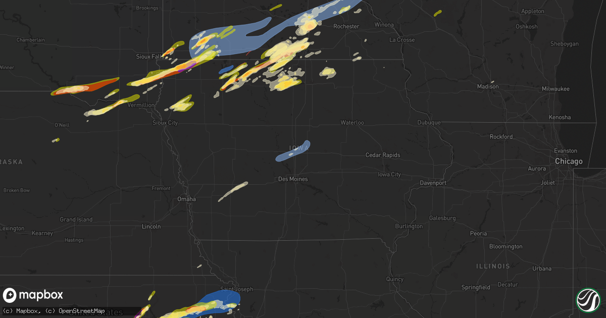
Hail Map in Iowa on April 28, 2025
Get this storm
April 28 map
$229
one time, instant access
Download today. No call, no setup
Keep the $229
Bought the map and want the full workflow? Apply the entire $229 to a subscription within 7 days. None of it is wasted.
Every map, not just this one
This buys you this map. Subscription and you get every map we run, in the markets you choose from a few cities to whole states to nationwide. Plus real-time alerts the moment a storm fires.
Contact data
Name, contact info, occupancy, even credit band for addresses in the footprint. You go from where it hit to who to call.
Become the source they trust
Unlimited branding weather history reports on demand. You already have the documented answer ready for the property owner, and you are the one who showed up with it.
Property data and RoofTrace estimates
Pull up any address you have got, its value and the exact code rules for that jurisdiction, straight from One Click Code. Then RoofTrace estimates the squares, pitch, and roof value, priced the way you price.
Storm reports in Iowa
Iowa
| Date | Description |
|---|---|
| 04/28/20256:54 PM CDT | Delayed report. Relayed through media partner. |
| 04/28/20256:48 PM CDT | A local report indicates 1.00 inch wind near 2 W Buffalo Center |
| 04/28/20256:43 PM CDT | Report via social media. |
| 04/28/20256:25 PM CDT | Report from mping: quarter |
| 04/28/20256:11 PM CDT | A local report indicates 1.00 inch wind near 2 WNW Oyens |
| 04/28/20256:04 PM CDT | Nickel to quarter size hail from 604 to 610 pm. A few stones slightly larger than quarter size. |
| 04/28/20256:04 PM CDT | A local report indicates 1.25 inch wind near 1 S Le Mars |
| 04/28/20255:44 PM CDT | Dime to golf ball sized hail. |
| 04/28/20255:31 PM CDT | Mostly dime to nickel but a few up to quarter. |
| 04/28/20255:20 PM CDT | Mostly dime to quarter sized... But some as large as ping pong balls. Time estimated via radar. |
| 04/28/20255:05 PM CDT | At estherville airport. |
| 04/28/20254:29 PM CDT | A local report indicates 1.00 inch wind near Fostoria |
| 04/28/20254:28 PM CDT | Estimated 50 to 60 mph wind gusts along with small branches down. Pea sized hail also reported. |
| 04/28/20258:40 AM CDT | A local report indicates 1.50 inch wind near Britt |
| 04/27/202511:27 PM CDT | Powerlines down and trees snapped. Shingles blown off a roof as well. |
| 04/27/202510:07 PM CDT | Personal weather station. |
| 04/27/202510:07 PM CDT | Personal weather station kianevad36. |
| 04/27/20259:53 PM CDT | A local report indicates 62 MPH wind near 2 S Ames |
| 04/27/20259:51 PM CDT | Demolished barn. Time estimate based on reported wind gust. |
| 04/27/20259:42 PM CDT | Report from mping: quarter |
| 04/27/20259:23 PM CDT | Report from mping: quarter |
| 04/27/20259:23 PM CDT | Report from mping: quarter |
| 04/27/20259:10 PM CDT | A local report indicates 1.00 inch wind near Garner |
| 04/27/20259:04 PM CDT | Branches down. Hail to the size of nickels. |
| 04/27/20258:40 PM CDT | A local report indicates 1.50 inch wind near 6 NW Garner |
| 04/27/20258:30 PM CDT | A local report indicates 1.00 inch wind near 5 E Wesley |
| 04/27/20258:13 PM CDT | A local report indicates 1.00 inch wind near 2 N Cherokee |
| 04/27/20257:35 PM CDT | Mesonet station rsyi4 sibley. |
| 04/27/20257:25 PM CDT | Quarter to half dollar sized hail reported via social media. |
| 04/27/20257:09 PM CDT | Ping pong to golf ball sized hail reported via social media. |
| 04/27/20257:08 PM CDT | Hen egg sized hail reported via broadcast media. |
| 04/27/20257:00 PM CDT | Report via social media. |
All States Impacted by Hail Map on April 28, 2025
Cities Impacted by Hail Map on April 28, 2025
- Franklin, MN
- Stewart, MN
- Hutchinson, MN
- Silver Lake, MN
- Readlyn, IA
- Eveleth, MN
- Owen, WI
- Hills, MN
- Valley Springs, SD
- Beaver Creek, MN
- Luverne, MN
- Hardwick, MN
- Kenneth, MN
- Lismore, MN
- Edgerton, MN
- Wilmont, MN
- Reading, MN
- Fulda, MN
- Worthington, MN
- Brewster, MN
- Heron Lake, MN
- Rushmore, MN
- Windom, MN
- Bingham Lake, MN
- Bigelow, MN
- Sibley, IA
- Round Lake, MN
- Ocheyedan, IA
- Lakefield, MN
- Okabena, MN
- Harris, IA
- Mountain Lake, MN
- Watkins, MN
- Litchfield, MN
- Kimball, MN
- South Haven, MN
- Neillsville, WI
- Greenwood, WI
- Willard, WI
- Midkiff, TX
- Warrens, WI
- Merrillan, WI
- Merrill, WI
- Saint Cloud, MN
- Clearwater, MN
- Madison, FL
- Greenville, FL
- Adrian, MN
- Iona, MN
- Jackson, MN
- Westbrook, MN
- Avoca, MN
- Jeffers, MN
- Lake Crystal, MN
- Odin, MN
- Butterfield, MN
- Sherburn, MN
- Hanska, MN
- Trimont, MN
- Darfur, MN
- Alpha, MN
- Nicollet, MN
- Ormsby, MN
- Storden, MN
- New Ulm, MN
- Courtland, MN
- Sleepy Eye, MN
- Comfrey, MN
- Madelia, MN
- Saint James, MN
- Clear Lake, MN
- Foley, MN
- Midland, TX
- Lewisville, MN
- Truman, MN
- Dunnell, MN
- Welcome, MN
- Fairmont, MN
- Ceylon, MN
- Vernon Center, MN
- Amboy, MN
- Princeton, MN
- Mankato, MN
- Saint Peter, MN
- Garden City, MN
- Cleveland, MN
- Granada, MN
- Winnebago, MN
- Oak Park, MN
- Becker, MN
- Milaca, MN
- Arlington, MN
- Albany, MN
- Fostoria, IA
- Spencer, IA
- Milford, IA
- Big Lake, TX
- Garden City, TX
- Spirit Lake, IA
- Arnolds Park, IA
- Terril, IA
- Estherville, IA
- Good Thunder, MN
- Mapleton, MN
- Dickens, IA
- Dolliver, IA
- Janesville, MN
- Pemberton, MN
- Saint Clair, MN
- Greenville, IA
- Royal, IA
- Linn Grove, IA
- Rembrandt, IA
- Sioux Rapids, IA
- Albert City, IA
- Webb, IA
- Marathon, IA
- Solomon, KS
- Salina, KS
- Foreston, MN
- Zimmerman, MN
- Monticello, MN
- New Cambria, KS
- Butte, NE
- Fairfax, SD
- Spencer, NE
- Lake Andes, SD
- Pickstown, SD
- Bristow, NE
- Wagner, SD
- Lynch, NE
- Warsaw, MN
- Waseca, MN
- Morristown, MN
- Faribault, MN
- Waterville, MN
- Medford, MN
- Owatonna, MN
- Blue Earth, MN
- Elmore, MN
- Abilene, KS
- Gypsum, KS
- Delavan, MN
- Sterling City, TX
- Three Lakes, WI
- Chapman, KS
- Enterprise, KS
- Argonne, WI
- Long Lake, WI
- Iron River, MI
- Gaastra, MI
- Longford, KS
- Wakefield, KS
- Clay Center, KS
- Riley, KS
- Leonardville, KS
- Green, KS
- Randolph, KS
- Dante, SD
- Avon, SD
- Tripp, SD
- Tyndall, SD
- Scotland, SD
- Tabor, SD
- Junction City, KS
- Milford, KS
- Fort Riley, KS
- Utica, SD
- Yankton, SD
- Manhattan, KS
- Ogden, KS
- Quanah, TX
- Waterville, KS
- Blue Rapids, KS
- Chillicothe, TX
- Frost, MN
- Bricelyn, MN
- Wells, MN
- Vernon, TX
- Ruthven, IA
- Ringsted, IA
- Swea City, IA
- Armstrong, IA
- Crystal Falls, MI
- Graettinger, IA
- Merrill, IA
- Le Mars, IA
- Verdigre, NE
- New Richland, MN
- Easton, MN
- Kenyon, MN
- Nerstrand, MN
- Emmetsburg, IA
- Ayrshire, IA
- Ellendale, MN
- Eldorado, OK
- Olustee, OK
- Fenton, IA
- Ledyard, IA
- Buffalo Center, IA
- Lakota, IA
- Wamego, KS
- Saint George, KS
- Bancroft, IA
- Zumbrota, MN
- West Concord, MN
- Dennison, MN
- Red Wing, MN
- Wanamingo, MN
- Goodhue, MN
- Cannon Falls, MN
- Mazeppa, MN
- Pine Island, MN
- Centerville, SD
- Alden, MN
- Aspermont, TX
- Hope, MN
- Claremont, MN
- Assaria, KS
- Irene, SD
- Wakonda, SD
- Viborg, SD
- Oyens, IA
- Remsen, IA
- Channing, MI
- Republic, MI
- Champion, MI
- Caspian, MI
- Hamlin, TX
- Florence, WI
- Alma, KS
- Paxico, KS
- Belvue, KS
- Center, NE
- Merkel, TX
- Ishpeming, MI
- Onaga, KS
- Hartland, MN
- Bloomfield, NE
- Niobrara, NE
- Beresford, SD
- Canton, SD
- Cylinder, IA
- Old Glory, TX
- Lesterville, SD
- Menno, SD
- Altus, OK
- Birnamwood, WI
- Freeborn, MN
- Blair, OK
- Mangum, OK
- Crofton, NE
- Robert Lee, TX
- Freeman, SD
- Lone Wolf, OK
- Paducah, TX
- Seymour, TX
- Hudson, SD
- Inwood, IA
- Fairview, SD
- Soldier, KS
- Havensville, KS
- Emmett, KS
- Doon, IA
- Rock Valley, IA
- Alvord, IA
- Holton, KS
- Delia, KS
- Saint Marys, KS
- Mayetta, KS
- Rock Rapids, IA
- Hull, IA
- Hawley, TX
- Anson, TX
- Zumbro Falls, MN
- Lake City, MN
- Clarks Grove, MN
- Worthing, SD
- Kiester, MN
- Albert Lea, MN
- Rake, IA
- Thompson, IA
- Titonka, IA
- Westmoreland, KS
- Ringle, WI
- Winnetoon, NE
- Aniwa, WI
- Wausau, WI
- Schofield, WI
- Lone Rock, IA
- Chambers, NE
- Granville, IA
- Marcus, IA
- Nolan, TX
- Hope, KS
- Maple Hill, KS
- Rossville, KS
- Hoyt, KS
- Hobart, OK
- Crowell, TX
- Scarville, IA
- Emmons, MN
- George, IA
- Little Rock, IA
- Crandon, WI
- Antigo, WI
- Millville, MN
- Blooming Prairie, MN
- Fordyce, NE
- Saint Helena, NE
- Gayville, SD
- Vermillion, SD
- Mission Hill, SD
- Volin, SD
- Laona, WI
- Merrifield, MN
- Crosby, MN
- Marion, WI
- Tigerton, WI
- Whittemore, IA
- Elton, WI
- Bryant, WI
- Abilene, TX
- Kellogg, MN
- Plainview, MN
- White Lake, WI
- Denison, KS
- Gleason, WI
- Burt, IA
- Conger, MN
- Nisswa, MN
- Frontenac, MN
- Maiden Rock, WI
- Stockholm, WI
- Pepin, WI
- Circleville, KS
- Whiting, KS
- Valley Falls, KS
- Arkansaw, WI
- Menomonie, WI
- Durand, WI
- Plum City, WI
- Eau Galle, WI
- Muscotah, KS
- Mondovi, WI
- Nelson, WI
- Effingham, KS
- Alma, WI
- Eleva, WI
- Eau Claire, WI
- Strum, WI
- Nortonville, KS
- Lancaster, KS
- Horton, KS
- Denton, KS
- Everest, KS
- Atchison, KS
- Winchester, KS
- Cummings, KS
- Dwight, KS
- Alta Vista, KS
- Verdon, NE
- Caroline, WI
- Algona, IA
- Neopit, WI
- Keshena, WI
- Twin Lakes, MN
- Glenville, MN
- Tye, TX
- Palisade, MN
- Forest City, IA
- Woden, IA
- Shawano, WI
- Leopolis, WI
- Hinton, IA
- Kingsley, IA
- Fall Creek, WI
- Osseo, WI
- Augusta, WI
- Wesley, IA
- Alcester, SD
- Falls City, NE
- Albany, TX
- Britt, IA
- Bendena, KS
- Troy, KS
- Saint Joseph, MO
- Wathena, KS
- Rushville, MO
- Weston, MO
- Agency, MO
- Faucett, MO
- De Kalb, MO
- Easton, KS
- Dearborn, MO
- Leavenworth, KS
- Duke, OK
- Mcgregor, MN
- Lake Mills, IA
- Joice, IA
- Suring, WI
- Gillett, WI
- Headrick, OK
- Leland, IA
- Tamarack, MN
- Corwith, IA
- Lewis, IA
- Mountain Park, OK
- Tipton, OK
- Griswold, IA
- Oconto Falls, WI
- Crystal Lake, IA
- Floodwood, MN
- Wright, MN
- Bessie, OK
- Conway Springs, KS
- Longdale, OK
- Valley Center, KS
- Corn, OK
- Ringwood, OK
- Clinton, OK
- Greenwich, KS
- Strong City, KS
- Sentinel, OK
- Whitewater, KS
- Clearwater, KS
- Wellington, KS
- Thomas, OK
- Granite, OK
- Goltry, OK
- Canton, OK
- Burns, KS
- Arapaho, OK
- Cedar Point, KS
- Council Grove, KS
- Isabella, OK
- Florence, KS
- Milan, KS
- Benton, KS
- Elmdale, KS
- Mayfield, KS
- Fairview, OK
- Haysville, KS
- Nash, OK
- Wichita, KS
- Oakwood, OK
- Caldwell, KS
- Hanlontown, IA
- Fertile, IA
- Peterson, IA
- Snyder, OK
- Oconto, WI
- Lena, WI
- Atlantic, IA
- Lu Verne, IA
- Garner, IA
- Thorp, WI
- Indiahoma, OK
- Elmer, OK
- Loyal, WI
- Altus Afb, OK
- Gillett Grove, IA
- Silver Lake, KS
- Roosevelt, OK
- Wiota, IA
- Chatfield, MN
- Fountain, MN
- Mountain, WI
- Coleman, WI
- Odell, TX
- Athelstane, WI
- Anita, IA
- Lakewood, WI
- Canyon, MN
- Saginaw, MN
- Exira, IA
- Woodbine, KS
- Topeka, KS
- White City, KS
- Duluth, MN
- Clear Lake, IA
- Lawton, OK
- Frederick, OK
- Herington, KS
- Ventura, IA
- Foss, OK
- Ozawkie, KS
- Oskaloosa, KS
- Cotton, MN
- Preston, MN
- Meriden, KS
- Sagola, MI
- Osage, IA
- Saint Ansgar, IA
- Plymouth, IA
- Grafton, IA
- Adair, IA
- Cordell, OK
- Pembine, WI
- McCamey, TX
- Mountain View, OK
- Weatherford, OK
- Geary, OK
- Le Roy, MN
- Spring Valley, MN
- Vulcan, MI
- Niagara, WI
- Amberg, WI
- Little Cedar, IA
- Nora Springs, IA
- Apache, OK
- Carnegie, OK
- Orchard, IA
- Rudd, IA
- Polk City, IA
- Elkhart, IA
- Huxley, IA
- Slater, IA
- Alleman, IA
- Cambridge, IA
- Ankeny, IA
- Grantville, KS
- Harmony, MN
- Lime Springs, IA
- Ames, IA
- Woodward, IA
- Boone, IA
- Madrid, IA
- Ogden, IA
- Kelley, IA
- Luther, IA
- Nevada, IA
- Zearing, IA
- McCallsburg, IA
- Colo, IA
- Platte City, MO
- Lost Springs, KS
- Harveyville, KS
- Eskridge, KS
- Perry, KS
- Roland, IA
- Anadarko, OK
- Finland, MN
- Auburn, KS
- Wilsey, KS
- Cyril, OK
- Cement, OK
- Manistique, MI
- Annandale, MN
- Maple Lake, MN
- Silver Bay, MN
- Chickasha, OK
- Andrews, TX
- Seminole, TX
- Wakarusa, KS
- Carbondale, KS
- Burlingame, KS
- Amber, OK
- Blanchard, OK
- Seagraves, TX
- Norman, OK
- Newcastle, OK
- Scranton, KS
- Alex, OK
- Washington, OK
- Jal, NM
- Decorah, IA
- Tecumseh, OK
- Tahoka, TX
- Brownfield, TX
- Shawnee, OK
- Welch, TX
- Purcell, OK
- Lexington, OK
- Earlsboro, OK
- Seminole, OK
- Noble, OK
- Paden, OK
- Boley, OK
- Okemah, OK
- Prague, OK
- Macomb, OK
- Maud, OK
- Loop, TX
- Castle, OK
- Wilson, TX
- Lamesa, TX
- Okmulgee, OK
- Weleetka, OK
- Odonnell, TX
- Henryetta, OK
- Morris, OK
- Crosbyton, TX
- Ralls, TX
- Boynton, OK
- Council Hill, OK
- Gail, TX
- Oktaha, OK
- Checotah, OK
- Muskogee, OK
- Taft, OK
- Haskell, OK
- Post, TX
- Kansas City, MO
- Lees Summit, MO
- Ewing, NE
- Grain Valley, MO
- Bates City, MO
- Oak Grove, MO
- Napoleon, MO
- Odessa, MO
- Blue Springs, MO
- Wellington, MO
- Lennox, SD
- Mayview, MO
- Lexington, MO
- Higginsville, MO
- Henrietta, MO
- Corder, MO
- Alma, MO
- Concordia, MO
- Waverly, MO
- Malta Bend, MO
- Girard, TX
- Independence, MO
- Blackburn, MO
- Westphalia, KS
- Burlington, KS
- Marshall, MO
- Chester, OK
- Saint Louis, MO
- Madison, WI
- Sun Prairie, WI
- Cleo Springs, OK
- Aline, OK
- Knox City, TX
- Munday, TX
- Goree, TX
- Woodward, OK
- Sharon, OK
- Mooreland, OK
- Helena, OK
- Lamont, OK
- Olney, TX
- Holliday, TX
- Pond Creek, OK
- Nardin, OK
- Deer Creek, OK
- Arnett, OK
- Blackwell, OK
- Medford, OK
- Pampa, TX
- Carrier, OK
- Waynoka, OK
- Enid, OK
- Miami, TX
- Okarche, OK
- Panhandle, TX
- White Deer, TX
- Devol, OK
- Grandfield, OK
- Loveland, OK
- Davidson, OK
- Harrold, TX
- Wichita Falls, TX
- Iowa Park, TX
- Burkburnett, TX
- Electra, TX
- Randlett, OK
- Walters, OK
- Chattanooga, OK
- Faxon, OK
- Fort Sill, OK
- Cache, OK
- Geronimo, OK
- Temple, OK
- Elgin, OK
- Pocasset, OK
- Austin, MN
- Hayward, MN
- Minco, OK
- Tuttle, OK
- Oklahoma City, OK
- Dexter, KS
- Hollandale, MN
- Tonkawa, OK
- Newkirk, OK
- Garber, OK
- Covington, OK
- Duncan, OK
- Spencer, OK
- Ponca City, OK
- Newalla, OK
- Mcloud, OK
- Luther, OK
- Jones, OK
- Harrah, OK
- Choctaw, OK
- Waukomis, OK
- Douglas, OK
- Bison, OK
- Burbank, OK
- Brazil, IN
- Marlow, OK
- Kaw City, OK
- Morrison, OK
- Red Rock, OK
- Pawnee, OK
- Shidler, OK
- Wellston, OK
- Fairfax, OK
- Chandler, OK
- Foster, OK
- Carney, OK
- Agra, OK
- Tryon, OK
- Stroud, OK
- Cushing, OK
- Pawhuska, OK
- Independence, KS
- Ralston, OK
- Copan, OK
- Marland, OK
- Reelsville, IN
- Havana, KS
- Elmore City, OK
- Rush Springs, OK
- Fletcher, OK
- Ninnekah, OK
- Verden, OK
- Bradley, OK
- Lindsay, OK
- Caney, KS
- Niotaze, KS
- Bartlesville, OK
- Ochelata, OK
- Oswego, KS
- Hominy, OK
- Dewey, OK
- Delaware, OK
- Wann, OK
- Coffeyville, KS
- Altamont, KS
- Barnsdall, OK
- Wynona, OK
- Mannford, OK
- S Coffeyville, OK
- Liberty, KS
- Edna, KS
- Mound Valley, KS
- Parsons, KS
- McCune, KS
- Columbus, KS
- Lenapah, OK
- Prairie Du Rocher, IL
- Osage, OK
- Prue, OK
- Skiatook, OK
- Ramona, OK
- Meeker, OK
- Sand Springs, OK
- Cleveland, OK
- Nowata, OK
- Sperry, OK
- Tulsa, OK
- Ashton, IA
- Steen, MN
- Mills, NE
- Sauk Rapids, MN
- Waldorf, MN
- Avon, MN
- Garretson, SD
- Minnesota Lake, MN
- Westfield, IA
- Ellsworth, MN
- Kanaranzi, MN
- Cresco, IA
- Springview, NE


