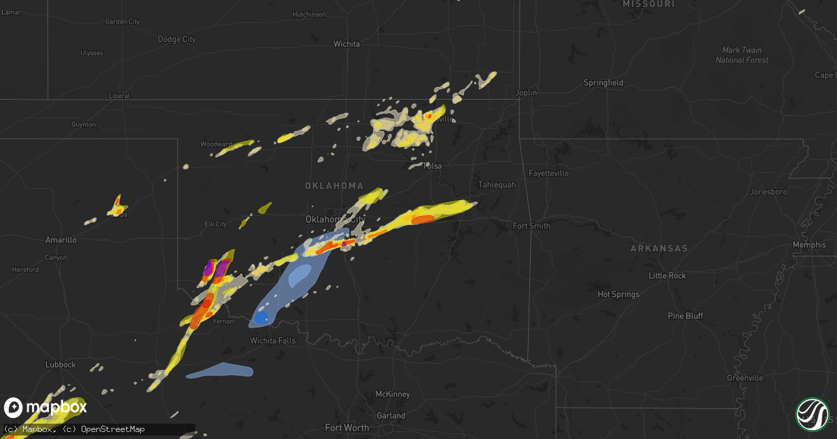
Hail Map on April 28, 2025
Get this storm
April 28 map
$229
one time, instant access
Download today. No call, no setup
Keep the $229
Bought the map and want the full workflow? Apply the entire $229 to a subscription within 7 days. None of it is wasted.
Every map, not just this one
This buys you this map. Subscription and you get every map we run, in the markets you choose from a few cities to whole states to nationwide. Plus real-time alerts the moment a storm fires.
Contact data
Name, contact info, occupancy, even credit band for addresses in the footprint. You go from where it hit to who to call.
Become the source they trust
Unlimited branding weather history reports on demand. You already have the documented answer ready for the property owner, and you are the one who showed up with it.
Property data and RoofTrace estimates
Pull up any address you have got, its value and the exact code rules for that jurisdiction, straight from One Click Code. Then RoofTrace estimates the squares, pitch, and roof value, priced the way you price.
States Impacted by Hail Map on April 28, 2025
Storm reports
Wisconsin
| Date | Description |
|---|---|
| 04/28/20256:56 PM CDT | A local report indicates 1.00 inch wind near 2 E Sunset |
| 04/28/20253:36 PM CDT | Report from mping: quarter |
| 04/28/20253:07 PM CDT | Public report relayed by broadcast media. |
| 04/28/20253:07 PM CDT | A local report indicates 1.25 inch wind near 2 SE Sidney |
| 04/27/202510:04 PM CDT | A local report indicates a tornado near Mattoon |
| 04/27/202510:04 PM CDT | Trees and power poles down. |
| 04/27/202510:02 PM CDT | A local report indicates a tornado near 3 E Birnamwood |
| 04/27/202510:02 PM CDT | . |
| 04/27/202510:00 PM CDT | Corrects time for previous tornado report from 3 e birnamwood. |
| 04/27/20259:25 PM CDT | Tree caught fire and fell on power line. |
| 04/27/20259:24 PM CDT | Delayed report. Reported by mobile trained weather spotter with measuring equipment northwest of mosinee. Confirmed by marathon county emergency manager. |
| 04/27/20258:23 PM CDT | A local report indicates 60 MPH wind near 5 W Withee |
| 04/27/20258:07 PM CDT | A confirmed tornado touched down south of augusta and traveled northeast across us-12 before dissipating north of fairchild. Both structure and tree damage were noted. |
| 04/27/20257:57 PM CDT | A brief tornado was confirmed near hale corner with minor tree and structure damage noted. Time estimated from radar. |
| 04/27/20257:55 PM CDT | Structure damage and photos confirm a tornado in southern eau claire county. The path may stretch to east of augusta. Time estimated from radar. |
| 04/27/20257:48 PM CDT | Corrects previous tornado report from 10 sw fall creek. A confirmed tornado briefly touched down just south of cleghorn and west of foster. Multiple pine trees were upr |
| 04/27/20257:33 PM CDT | A confirmed tornado touched down northeast of mondovi in buffalo county then lifted after briefly crossing into southern eau claire county. Some structure and tree dama |
Kansas
| Date | Description |
|---|---|
| 04/28/20256:55 PM CDT | Photos on social media. Mainly nickel sized... With a few quarter sized mixing in. |
| 04/28/20256:54 PM CDT | A local report indicates 60 MPH wind near 8 S Abilene |
| 04/28/20256:46 PM CDT | Outbuilding damaged. |
| 04/28/20256:37 PM CDT | Storm chaser videos showed what was originally a gustnado feature becoming connected to the updraft on the leading edge of the gust front as it moved through belvue. Th |
| 04/28/20256:31 PM CDT | Weather station measured 68 mph wind gust 3 northwest of wamego at 631pm. |
| 04/28/20256:28 PM CDT | A local report indicates 60 MPH wind near 2 ESE Saint George |
| 04/28/20256:25 PM CDT | Via social media photo. Delayed report. |
| 04/28/20256:15 PM CDT | Photos on social media. |
| 04/28/20256:12 PM CDT | A local report indicates 1.00 inch wind near 5 NNW Junction City |
| 04/28/20256:11 PM CDT | A local report indicates 1.50 inch wind near 2 NE Ogden |
| 04/28/20255:58 PM CDT | A local report indicates 1.00 inch wind near Blue Rapids |
| 04/28/20255:53 PM CDT | A local report indicates 1.00 inch wind near 5 SSE Milford |
| 04/28/20255:45 PM CDT | Via social media photo. Delayed report. |
| 04/28/20255:39 PM CDT | A local report indicates 1.50 inch wind near Abilene |
| 04/28/20255:37 PM CDT | A local report indicates 1.00 inch wind near 1 N Abilene |
| 04/28/20255:36 PM CDT | Photos shared to nws employee. Radar estimated time. |
| 04/28/20255:30 PM CDT | Corrects previous hail report from 3 w leonardville. Photos shared to nws employee. Radar estimated time. |
| 04/28/20255:18 PM CDT | Corrects previous hail report from 3 e new cambria. |
| 04/28/20255:18 PM CDT | A local report indicates 2.00 inch wind near 3 E New Cambria |
| 04/28/20255:15 PM CDT | A local report indicates 1.50 inch wind near 4 WSW Wakefield |
| 04/28/20254:56 PM CDT | A local report indicates 1.50 inch wind near Solomon |
| 04/27/20257:41 PM CDT | Reported via private weather sensor. Time confirmed from radar. |
| 04/27/20257:35 PM CDT | A local report indicates 70 MPH wind near 3 W Huron |
| 04/27/20257:30 PM CDT | A local report indicates 1.00 inch wind near 5 N Louisville |
| 04/27/20257:00 PM CDT | Building damage. Time estimated by radar. |
Iowa
| Date | Description |
|---|---|
| 04/28/20256:54 PM CDT | Delayed report. Relayed through media partner. |
| 04/28/20256:48 PM CDT | A local report indicates 1.00 inch wind near 2 W Buffalo Center |
| 04/28/20256:43 PM CDT | Report via social media. |
| 04/28/20256:25 PM CDT | Report from mping: quarter |
| 04/28/20256:11 PM CDT | A local report indicates 1.00 inch wind near 2 WNW Oyens |
| 04/28/20256:04 PM CDT | Nickel to quarter size hail from 604 to 610 pm. A few stones slightly larger than quarter size. |
| 04/28/20256:04 PM CDT | A local report indicates 1.25 inch wind near 1 S Le Mars |
| 04/28/20255:44 PM CDT | Dime to golf ball sized hail. |
| 04/28/20255:31 PM CDT | Mostly dime to nickel but a few up to quarter. |
| 04/28/20255:20 PM CDT | Mostly dime to quarter sized... But some as large as ping pong balls. Time estimated via radar. |
| 04/28/20255:05 PM CDT | At estherville airport. |
| 04/28/20254:29 PM CDT | A local report indicates 1.00 inch wind near Fostoria |
| 04/28/20254:28 PM CDT | Estimated 50 to 60 mph wind gusts along with small branches down. Pea sized hail also reported. |
| 04/28/20258:40 AM CDT | A local report indicates 1.50 inch wind near Britt |
| 04/27/202511:27 PM CDT | Powerlines down and trees snapped. Shingles blown off a roof as well. |
| 04/27/202510:07 PM CDT | Personal weather station. |
| 04/27/202510:07 PM CDT | Personal weather station kianevad36. |
| 04/27/20259:53 PM CDT | A local report indicates 62 MPH wind near 2 S Ames |
| 04/27/20259:51 PM CDT | Demolished barn. Time estimate based on reported wind gust. |
| 04/27/20259:42 PM CDT | Report from mping: quarter |
| 04/27/20259:23 PM CDT | Report from mping: quarter |
| 04/27/20259:23 PM CDT | Report from mping: quarter |
| 04/27/20259:10 PM CDT | A local report indicates 1.00 inch wind near Garner |
| 04/27/20259:04 PM CDT | Branches down. Hail to the size of nickels. |
| 04/27/20258:40 PM CDT | A local report indicates 1.50 inch wind near 6 NW Garner |
| 04/27/20258:30 PM CDT | A local report indicates 1.00 inch wind near 5 E Wesley |
| 04/27/20258:13 PM CDT | A local report indicates 1.00 inch wind near 2 N Cherokee |
| 04/27/20257:35 PM CDT | Mesonet station rsyi4 sibley. |
| 04/27/20257:25 PM CDT | Quarter to half dollar sized hail reported via social media. |
| 04/27/20257:09 PM CDT | Ping pong to golf ball sized hail reported via social media. |
| 04/27/20257:08 PM CDT | Hen egg sized hail reported via broadcast media. |
| 04/27/20257:00 PM CDT | Report via social media. |
Minnesota
| Date | Description |
|---|---|
| 04/28/20256:52 PM CDT | Relayed via emergency manager. |
| 04/28/20256:45 PM CDT | A local report indicates 1.25 inch wind near 4 SSW Alden |
| 04/28/20256:42 PM CDT | A local report indicates 1.00 inch wind near Mazeppa |
| 04/28/20256:15 PM CDT | Picture via x showing golf ball sized hail. |
| 04/28/20256:13 PM CDT | Measurement provided via phone. |
| 04/28/20256:10 PM CDT | Measurement provided via phone. |
| 04/28/20256:00 PM CDT | Photos provided of roof damage reported to large commercial warehouse in kenyon. Time estimated via radar. |
| 04/28/20255:55 PM CDT | Brief tornado visible in video and photos of structure damage to a farm. Lofted debris blown downstream about a mile. Time estimated from radar. |
| 04/28/20255:54 PM CDT | A local report indicates 1.25 inch wind near 6 NE Frost |
| 04/28/20255:50 PM CDT | Barn destroyed... Silos destroyed... Semi tipped over. Time estimated via radar. |
| 04/28/20255:40 PM CDT | Delayed report... Time estimated from radar. Roof blown off shed near 250th street east of morristown. |
| 04/28/20255:34 PM CDT | Amateur radio operator provided photo of large pine tree blown over. |
| 04/28/20254:40 PM CDT | Delayed report via x with picture of 1.5 inch hail. |
| 04/28/20254:38 PM CDT | Time estimated via radar. |
| 04/28/20254:34 PM CDT | Time estimated via radar. Photo measurement provided. |
| 04/28/20254:30 PM CDT | Picture via x. |
| 04/28/20254:16 PM CDT | Delayed report of ping pong sized hail north of clearwater via facebook. Time estimated from radar. |
| 04/28/20254:06 PM CDT | Time estimated via radar. Photo measurement provided. |
| 04/28/20253:33 PM CDT | A local report indicates 60 MPH wind near 5 NW Jackson |
| 04/28/20253:18 PM CDT | Ground covered in nickel to quarter size hail. |
| 04/28/20253:16 PM CDT | A local report indicates 1.00 inch wind near Windom |
| 04/28/20253:06 PM CDT | A local report indicates 1.00 inch wind near 3 SE Brewster |
| 04/28/20252:54 PM CDT | Lots of quarter size hail. |
| 04/28/20252:45 PM CDT | Report via social media. |
| 04/28/20252:40 PM CDT | Brief touchdown in an open field. No known damage. |
| 04/28/20251:27 PM CDT | Non-uniform hail measured at 2.8 inches at its widest. |
| 04/28/20251:26 PM CDT | Report from mping: hen egg |
| 04/28/20251:15 PM CDT | A local report indicates 1.00 inch wind near Beaver Creek |
| 04/27/20257:59 PM CDT | Report from mping: quarter |
| 04/27/20257:00 PM CDT | A local report indicates 1.50 inch wind near 2 N Albert Lea |
South Dakota
| Date | Description |
|---|---|
| 04/28/20256:48 PM CDT | Report via social media. |
| 04/28/20256:43 PM CDT | Hail up to quarter size along u.s. Highway 18 and minnesota ave. |
| 04/28/20256:28 PM CDT | Quarter to golf ball sized hail reported via social media. |
| 04/28/20255:35 PM CDT | Quarters to slightly larger hail reported via social media. Time estimated by radar. |
| 04/27/20257:17 PM CDT | A local report indicates 1.00 inch wind near 3 ESE Gayville |
Missouri
| Date | Description |
|---|---|
| 04/28/20252:42 AM CDT | Personal weather station gust. |
| 04/28/20252:42 AM CDT | Private weather sensor. |
| 04/28/20252:30 AM CDT | Mesonet station moa29 alma. |
| 04/28/20251:54 AM CDT | Report from mping: quarter |
| 04/27/20258:40 PM CDT | Downed wires near standsford avenue. Time estimated from radar. |
| 04/27/20258:15 PM CDT | Downed wires near kyle road. Time based on dispatch report and confirmed from radar. |
| 04/27/20258:11 PM CDT | Time estimated via radar. |
Michigan
| Date | Description |
|---|---|
| 04/28/20256:10 PM CDT | Report via social media. |
| 04/28/20255:55 PM CDT | Estimated 1.5in hail stone. Report via social media comment. |
| 04/28/20255:48 PM CDT | Image from local news. Time estimated via radar. |
Oklahoma
| Date | Description |
|---|---|
| 04/28/20256:56 PM CDT | A local report indicates 1.00 inch wind near 3 NNW Blair |
| 04/28/20256:51 PM CDT | A local report indicates 2.00 inch wind near 2 S Blair |
| 04/28/20256:51 PM CDT | Report from mping: hen egg |
| 04/28/20256:48 PM CDT | Report from mping: quarter |
| 04/28/20256:45 PM CDT | Report from mping: quarter |
| 04/28/20256:35 PM CDT | Report from mping: quarter |
| 04/28/20256:47 AM CDT | Report from mping: half dollar |
| 04/28/20256:40 AM CDT | A local report indicates 1.75 inch wind near 2 NW Bartlesville |
| 04/28/20256:35 AM CDT | Dime to occasional quarter size hail. Winds estimated at 50 mph. |
| 04/28/20256:35 AM CDT | Report from mping: half dollar |
| 04/28/20256:00 AM CDT | A local report indicates 1.25 inch wind near 3 WNW Chandler |
| 04/28/20255:30 AM CDT | A local report indicates 59 MPH wind near 4 WNW Rush Springs |
| 04/28/20255:25 AM CDT | Rush springs mesonet. |
| 04/28/20255:03 AM CDT | A local report indicates 64 MPH wind near 6 SE Lawton |
| 04/28/20255:00 AM CDT | Walters mesonet. |
| 04/28/20254:55 AM CDT | Walters mesonet. |
| 04/28/20254:35 AM CDT | A local report indicates 64 MPH wind near 3 W Grandfield |
| 04/28/20254:35 AM CDT | Horse trailer rolled along with extensive damage to outbuildings on property. Also significant tree damage. |
| 04/28/20254:32 AM CDT | Large metal car port damage on far west side of grandfield. Time estimated by severe wind gust at grandfield mesonet. |
| 04/28/20254:32 AM CDT | Roof damage to home on south side of grandfield. |
| 04/28/20254:30 AM CDT | Grandfield mesonet. |
| 04/27/202511:48 PM CDT | Report from mping: quarter |
| 04/27/202511:47 PM CDT | Report from mping: quarter |
| 04/27/202511:46 PM CDT | Corrects time for previous hail report from 2 ne noble. |
| 04/27/202511:45 PM CDT | Time estimated by radar. |
| 04/27/202511:41 PM CDT | Report from mping: quarter |
| 04/27/202511:39 PM CDT | Report from mping: ping pong ball |
| 04/27/202511:38 PM CDT | Report from mping: quarter |
| 04/27/202511:38 PM CDT | Report from mping: quarter |
| 04/27/202511:37 PM CDT | Report from mping: half dollar |
| 04/27/202511:30 PM CDT | Report from mping: golf ball |
| 04/27/202511:29 PM CDT | Report from mping: quarter |
| 04/27/202511:26 PM CDT | Report from mping: quarter |
| 04/27/202511:26 PM CDT | A local report indicates 1.00 inch wind near Blanchard |
| 04/27/202511:15 PM CDT | Report from mping: quarter |
| 04/27/202511:13 PM CDT | Report from mping: ping pong ball |
| 04/27/202511:11 PM CDT | Report from mping: quarter |
| 04/27/202511:07 PM CDT | Report from mping: quarter |
| 04/27/202510:42 PM CDT | Lots of hail below 1 inch with some quarter size hail. Location is s creek and benson park rd. |
| 04/27/20259:09 PM CDT | Corrects previous hail report from public to trained spotter. |
| 04/27/20258:45 PM CDT | Report from mping: quarter |
| 04/27/20258:33 PM CDT | Photos on social media and nwschat. |
| 04/27/20258:32 PM CDT | Report from mping: tea cup |
| 04/27/20258:29 PM CDT | Report from mping: half dollar |
| 04/27/20257:53 PM CDT | A local report indicates 1.00 inch wind near Altus |
Nebraska
| Date | Description |
|---|---|
| 04/28/20256:34 PM CDT | A local report indicates 1.00 inch wind near 3 N Center |
| 04/28/20256:00 PM CDT | Report and photo via social media. |
| 04/27/20257:10 PM CDT | Delayed report. |
| 04/27/20257:02 PM CDT | Public caller reported lots of hail falling down with the largest being ping pong ball sized. |
Texas
| Date | Description |
|---|---|
| 04/28/20256:27 PM CDT | A local report indicates 1.00 inch wind near 1 W Sterling City |
| 04/28/20256:08 PM CDT | A local report indicates 1.75 inch wind near Chillicothe |
| 04/28/20256:07 PM CDT | A local report indicates 1.75 inch wind near 3 SSE Chillicothe |
| 04/28/20256:01 PM CDT | A local report indicates 1.00 inch wind near 3 S Chillicothe |
| 04/28/20255:21 PM CDT | Ping pong ball size hail reported by nws employee about 5 miles ene of saint lawrence. |
| 04/28/20253:57 PM CDT | Ping pong to golf ball size hail reported by public via social media. Time was estimated by radar. |
| 04/28/20254:29 AM CDT | A local report indicates 1.50 inch wind near 1 NE Pampa |
| 04/28/20254:25 AM CDT | A local report indicates 1.00 inch wind near 1 NE Pampa |
| 04/28/20254:10 AM CDT | Tree and power pole damage. Also several metal sheds damaged in and around punkin center. Time estimated by radar. |
| 04/28/20254:05 AM CDT | Downed power poles. Also roof damage to several homes. Time is estimated by radar. |
| 04/28/20254:00 AM CDT | Wind damage from possible wake low from thunderstorm complex near del rio high school along memorial drive and avondale street. Roof damage to several buildings at apar |
| 04/28/20253:54 AM CDT | Corrects previous non-tstm wnd gst report from 2 wnw del rio. Asos station kdrt del rio intl airport gust from a possible wake low event with thunderstorm nearby. |
| 04/28/20253:45 AM CDT | A local report indicates 60 MPH wind near 3 NW Seymour |
| 04/28/20253:35 AM CDT | A local report indicates 68 MPH wind near 3 NW Goree |
| 04/28/20253:15 AM CDT | A local report indicates 60 MPH wind near 4 NNW Goree |
| 04/28/20252:12 AM CDT | Measured by ttu mesonet. |
| 04/28/20251:33 AM CDT | Measured by ttu mesonet. |
| 04/28/202512:54 AM CDT | Measured by ttu mesonet. |
| 04/27/202511:27 PM CDT | A local report indicates 1.75 inch wind near 5 E Seminole |
Cities Impacted by Hail Map on April 28, 2025
- Franklin, MN
- Stewart, MN
- Hutchinson, MN
- Silver Lake, MN
- Readlyn, IA
- Eveleth, MN
- Owen, WI
- Hills, MN
- Valley Springs, SD
- Beaver Creek, MN
- Luverne, MN
- Hardwick, MN
- Kenneth, MN
- Lismore, MN
- Edgerton, MN
- Wilmont, MN
- Reading, MN
- Fulda, MN
- Worthington, MN
- Brewster, MN
- Heron Lake, MN
- Rushmore, MN
- Windom, MN
- Bingham Lake, MN
- Bigelow, MN
- Sibley, IA
- Round Lake, MN
- Ocheyedan, IA
- Lakefield, MN
- Okabena, MN
- Harris, IA
- Mountain Lake, MN
- Watkins, MN
- Litchfield, MN
- Kimball, MN
- South Haven, MN
- Neillsville, WI
- Greenwood, WI
- Willard, WI
- Midkiff, TX
- Warrens, WI
- Merrillan, WI
- Merrill, WI
- Saint Cloud, MN
- Clearwater, MN
- Madison, FL
- Greenville, FL
- Adrian, MN
- Iona, MN
- Jackson, MN
- Westbrook, MN
- Avoca, MN
- Jeffers, MN
- Lake Crystal, MN
- Odin, MN
- Butterfield, MN
- Sherburn, MN
- Hanska, MN
- Trimont, MN
- Darfur, MN
- Alpha, MN
- Nicollet, MN
- Ormsby, MN
- Storden, MN
- New Ulm, MN
- Courtland, MN
- Sleepy Eye, MN
- Comfrey, MN
- Madelia, MN
- Saint James, MN
- Clear Lake, MN
- Foley, MN
- Midland, TX
- Lewisville, MN
- Truman, MN
- Dunnell, MN
- Welcome, MN
- Fairmont, MN
- Ceylon, MN
- Vernon Center, MN
- Amboy, MN
- Princeton, MN
- Mankato, MN
- Saint Peter, MN
- Garden City, MN
- Cleveland, MN
- Granada, MN
- Winnebago, MN
- Oak Park, MN
- Becker, MN
- Milaca, MN
- Arlington, MN
- Albany, MN
- Fostoria, IA
- Spencer, IA
- Milford, IA
- Big Lake, TX
- Garden City, TX
- Spirit Lake, IA
- Arnolds Park, IA
- Terril, IA
- Estherville, IA
- Good Thunder, MN
- Mapleton, MN
- Dickens, IA
- Dolliver, IA
- Janesville, MN
- Pemberton, MN
- Saint Clair, MN
- Greenville, IA
- Royal, IA
- Linn Grove, IA
- Rembrandt, IA
- Sioux Rapids, IA
- Albert City, IA
- Webb, IA
- Marathon, IA
- Solomon, KS
- Salina, KS
- Foreston, MN
- Zimmerman, MN
- Monticello, MN
- New Cambria, KS
- Butte, NE
- Fairfax, SD
- Spencer, NE
- Lake Andes, SD
- Pickstown, SD
- Bristow, NE
- Wagner, SD
- Lynch, NE
- Warsaw, MN
- Waseca, MN
- Morristown, MN
- Faribault, MN
- Waterville, MN
- Medford, MN
- Owatonna, MN
- Blue Earth, MN
- Elmore, MN
- Abilene, KS
- Gypsum, KS
- Delavan, MN
- Sterling City, TX
- Three Lakes, WI
- Chapman, KS
- Enterprise, KS
- Argonne, WI
- Long Lake, WI
- Iron River, MI
- Gaastra, MI
- Longford, KS
- Wakefield, KS
- Clay Center, KS
- Riley, KS
- Leonardville, KS
- Green, KS
- Randolph, KS
- Dante, SD
- Avon, SD
- Tripp, SD
- Tyndall, SD
- Scotland, SD
- Tabor, SD
- Junction City, KS
- Milford, KS
- Fort Riley, KS
- Utica, SD
- Yankton, SD
- Manhattan, KS
- Ogden, KS
- Quanah, TX
- Waterville, KS
- Blue Rapids, KS
- Chillicothe, TX
- Frost, MN
- Bricelyn, MN
- Wells, MN
- Vernon, TX
- Ruthven, IA
- Ringsted, IA
- Swea City, IA
- Armstrong, IA
- Crystal Falls, MI
- Graettinger, IA
- Merrill, IA
- Le Mars, IA
- Verdigre, NE
- New Richland, MN
- Easton, MN
- Kenyon, MN
- Nerstrand, MN
- Emmetsburg, IA
- Ayrshire, IA
- Ellendale, MN
- Eldorado, OK
- Olustee, OK
- Fenton, IA
- Ledyard, IA
- Buffalo Center, IA
- Lakota, IA
- Wamego, KS
- Saint George, KS
- Bancroft, IA
- Zumbrota, MN
- West Concord, MN
- Dennison, MN
- Red Wing, MN
- Wanamingo, MN
- Goodhue, MN
- Cannon Falls, MN
- Mazeppa, MN
- Pine Island, MN
- Centerville, SD
- Alden, MN
- Aspermont, TX
- Hope, MN
- Claremont, MN
- Assaria, KS
- Irene, SD
- Wakonda, SD
- Viborg, SD
- Oyens, IA
- Remsen, IA
- Channing, MI
- Republic, MI
- Champion, MI
- Caspian, MI
- Hamlin, TX
- Florence, WI
- Alma, KS
- Paxico, KS
- Belvue, KS
- Center, NE
- Merkel, TX
- Ishpeming, MI
- Onaga, KS
- Hartland, MN
- Bloomfield, NE
- Niobrara, NE
- Beresford, SD
- Canton, SD
- Cylinder, IA
- Old Glory, TX
- Lesterville, SD
- Menno, SD
- Altus, OK
- Birnamwood, WI
- Freeborn, MN
- Blair, OK
- Mangum, OK
- Crofton, NE
- Robert Lee, TX
- Freeman, SD
- Lone Wolf, OK
- Paducah, TX
- Seymour, TX
- Hudson, SD
- Inwood, IA
- Fairview, SD
- Soldier, KS
- Havensville, KS
- Emmett, KS
- Doon, IA
- Rock Valley, IA
- Alvord, IA
- Holton, KS
- Delia, KS
- Saint Marys, KS
- Mayetta, KS
- Rock Rapids, IA
- Hull, IA
- Hawley, TX
- Anson, TX
- Zumbro Falls, MN
- Lake City, MN
- Clarks Grove, MN
- Worthing, SD
- Kiester, MN
- Albert Lea, MN
- Rake, IA
- Thompson, IA
- Titonka, IA
- Westmoreland, KS
- Ringle, WI
- Winnetoon, NE
- Aniwa, WI
- Wausau, WI
- Schofield, WI
- Lone Rock, IA
- Chambers, NE
- Granville, IA
- Marcus, IA
- Nolan, TX
- Hope, KS
- Maple Hill, KS
- Rossville, KS
- Hoyt, KS
- Hobart, OK
- Crowell, TX
- Scarville, IA
- Emmons, MN
- George, IA
- Little Rock, IA
- Crandon, WI
- Antigo, WI
- Millville, MN
- Blooming Prairie, MN
- Fordyce, NE
- Saint Helena, NE
- Gayville, SD
- Vermillion, SD
- Mission Hill, SD
- Volin, SD
- Laona, WI
- Merrifield, MN
- Crosby, MN
- Marion, WI
- Tigerton, WI
- Whittemore, IA
- Elton, WI
- Bryant, WI
- Abilene, TX
- Kellogg, MN
- Plainview, MN
- White Lake, WI
- Denison, KS
- Gleason, WI
- Burt, IA
- Conger, MN
- Nisswa, MN
- Frontenac, MN
- Maiden Rock, WI
- Stockholm, WI
- Pepin, WI
- Circleville, KS
- Whiting, KS
- Valley Falls, KS
- Arkansaw, WI
- Menomonie, WI
- Durand, WI
- Plum City, WI
- Eau Galle, WI
- Muscotah, KS
- Mondovi, WI
- Nelson, WI
- Effingham, KS
- Alma, WI
- Eleva, WI
- Eau Claire, WI
- Strum, WI
- Nortonville, KS
- Lancaster, KS
- Horton, KS
- Denton, KS
- Everest, KS
- Atchison, KS
- Winchester, KS
- Cummings, KS
- Dwight, KS
- Alta Vista, KS
- Verdon, NE
- Caroline, WI
- Algona, IA
- Neopit, WI
- Keshena, WI
- Twin Lakes, MN
- Glenville, MN
- Tye, TX
- Palisade, MN
- Forest City, IA
- Woden, IA
- Shawano, WI
- Leopolis, WI
- Hinton, IA
- Kingsley, IA
- Fall Creek, WI
- Osseo, WI
- Augusta, WI
- Wesley, IA
- Alcester, SD
- Falls City, NE
- Albany, TX
- Britt, IA
- Bendena, KS
- Troy, KS
- Saint Joseph, MO
- Wathena, KS
- Rushville, MO
- Weston, MO
- Agency, MO
- Faucett, MO
- De Kalb, MO
- Easton, KS
- Dearborn, MO
- Leavenworth, KS
- Duke, OK
- Mcgregor, MN
- Lake Mills, IA
- Joice, IA
- Suring, WI
- Gillett, WI
- Headrick, OK
- Leland, IA
- Tamarack, MN
- Corwith, IA
- Lewis, IA
- Mountain Park, OK
- Tipton, OK
- Griswold, IA
- Oconto Falls, WI
- Crystal Lake, IA
- Floodwood, MN
- Wright, MN
- Bessie, OK
- Conway Springs, KS
- Longdale, OK
- Valley Center, KS
- Corn, OK
- Ringwood, OK
- Clinton, OK
- Greenwich, KS
- Strong City, KS
- Sentinel, OK
- Whitewater, KS
- Clearwater, KS
- Wellington, KS
- Thomas, OK
- Granite, OK
- Goltry, OK
- Canton, OK
- Burns, KS
- Arapaho, OK
- Cedar Point, KS
- Council Grove, KS
- Isabella, OK
- Florence, KS
- Milan, KS
- Benton, KS
- Elmdale, KS
- Mayfield, KS
- Fairview, OK
- Haysville, KS
- Nash, OK
- Wichita, KS
- Oakwood, OK
- Caldwell, KS
- Hanlontown, IA
- Fertile, IA
- Peterson, IA
- Snyder, OK
- Oconto, WI
- Lena, WI
- Atlantic, IA
- Lu Verne, IA
- Garner, IA
- Thorp, WI
- Indiahoma, OK
- Elmer, OK
- Loyal, WI
- Altus Afb, OK
- Gillett Grove, IA
- Silver Lake, KS
- Roosevelt, OK
- Wiota, IA
- Chatfield, MN
- Fountain, MN
- Mountain, WI
- Coleman, WI
- Odell, TX
- Athelstane, WI
- Anita, IA
- Lakewood, WI
- Canyon, MN
- Saginaw, MN
- Exira, IA
- Woodbine, KS
- Topeka, KS
- White City, KS
- Duluth, MN
- Clear Lake, IA
- Lawton, OK
- Frederick, OK
- Herington, KS
- Ventura, IA
- Foss, OK
- Ozawkie, KS
- Oskaloosa, KS
- Cotton, MN
- Preston, MN
- Meriden, KS
- Sagola, MI
- Osage, IA
- Saint Ansgar, IA
- Plymouth, IA
- Grafton, IA
- Adair, IA
- Cordell, OK
- Pembine, WI
- McCamey, TX
- Mountain View, OK
- Weatherford, OK
- Geary, OK
- Le Roy, MN
- Spring Valley, MN
- Vulcan, MI
- Niagara, WI
- Amberg, WI
- Little Cedar, IA
- Nora Springs, IA
- Apache, OK
- Carnegie, OK
- Orchard, IA
- Rudd, IA
- Polk City, IA
- Elkhart, IA
- Huxley, IA
- Slater, IA
- Alleman, IA
- Cambridge, IA
- Ankeny, IA
- Grantville, KS
- Harmony, MN
- Lime Springs, IA
- Ames, IA
- Woodward, IA
- Boone, IA
- Madrid, IA
- Ogden, IA
- Kelley, IA
- Luther, IA
- Nevada, IA
- Zearing, IA
- McCallsburg, IA
- Colo, IA
- Platte City, MO
- Lost Springs, KS
- Harveyville, KS
- Eskridge, KS
- Perry, KS
- Roland, IA
- Anadarko, OK
- Finland, MN
- Auburn, KS
- Wilsey, KS
- Cyril, OK
- Cement, OK
- Manistique, MI
- Annandale, MN
- Maple Lake, MN
- Silver Bay, MN
- Chickasha, OK
- Andrews, TX
- Seminole, TX
- Wakarusa, KS
- Carbondale, KS
- Burlingame, KS
- Amber, OK
- Blanchard, OK
- Seagraves, TX
- Norman, OK
- Newcastle, OK
- Scranton, KS
- Alex, OK
- Washington, OK
- Jal, NM
- Decorah, IA
- Tecumseh, OK
- Tahoka, TX
- Brownfield, TX
- Shawnee, OK
- Welch, TX
- Purcell, OK
- Lexington, OK
- Earlsboro, OK
- Seminole, OK
- Noble, OK
- Paden, OK
- Boley, OK
- Okemah, OK
- Prague, OK
- Macomb, OK
- Maud, OK
- Loop, TX
- Castle, OK
- Wilson, TX
- Lamesa, TX
- Okmulgee, OK
- Weleetka, OK
- Odonnell, TX
- Henryetta, OK
- Morris, OK
- Crosbyton, TX
- Ralls, TX
- Boynton, OK
- Council Hill, OK
- Gail, TX
- Oktaha, OK
- Checotah, OK
- Muskogee, OK
- Taft, OK
- Haskell, OK
- Post, TX
- Kansas City, MO
- Lees Summit, MO
- Ewing, NE
- Grain Valley, MO
- Bates City, MO
- Oak Grove, MO
- Napoleon, MO
- Odessa, MO
- Blue Springs, MO
- Wellington, MO
- Lennox, SD
- Mayview, MO
- Lexington, MO
- Higginsville, MO
- Henrietta, MO
- Corder, MO
- Alma, MO
- Concordia, MO
- Waverly, MO
- Malta Bend, MO
- Girard, TX
- Independence, MO
- Blackburn, MO
- Westphalia, KS
- Burlington, KS
- Marshall, MO
- Chester, OK
- Saint Louis, MO
- Madison, WI
- Sun Prairie, WI
- Cleo Springs, OK
- Aline, OK
- Knox City, TX
- Munday, TX
- Goree, TX
- Woodward, OK
- Sharon, OK
- Mooreland, OK
- Helena, OK
- Lamont, OK
- Olney, TX
- Holliday, TX
- Pond Creek, OK
- Nardin, OK
- Deer Creek, OK
- Arnett, OK
- Blackwell, OK
- Medford, OK
- Pampa, TX
- Carrier, OK
- Waynoka, OK
- Enid, OK
- Miami, TX
- Okarche, OK
- Panhandle, TX
- White Deer, TX
- Devol, OK
- Grandfield, OK
- Loveland, OK
- Davidson, OK
- Harrold, TX
- Wichita Falls, TX
- Iowa Park, TX
- Burkburnett, TX
- Electra, TX
- Randlett, OK
- Walters, OK
- Chattanooga, OK
- Faxon, OK
- Fort Sill, OK
- Cache, OK
- Geronimo, OK
- Temple, OK
- Elgin, OK
- Pocasset, OK
- Austin, MN
- Hayward, MN
- Minco, OK
- Tuttle, OK
- Oklahoma City, OK
- Dexter, KS
- Hollandale, MN
- Tonkawa, OK
- Newkirk, OK
- Garber, OK
- Covington, OK
- Duncan, OK
- Spencer, OK
- Ponca City, OK
- Newalla, OK
- Mcloud, OK
- Luther, OK
- Jones, OK
- Harrah, OK
- Choctaw, OK
- Waukomis, OK
- Douglas, OK
- Bison, OK
- Burbank, OK
- Brazil, IN
- Marlow, OK
- Kaw City, OK
- Morrison, OK
- Red Rock, OK
- Pawnee, OK
- Shidler, OK
- Wellston, OK
- Fairfax, OK
- Chandler, OK
- Foster, OK
- Carney, OK
- Agra, OK
- Tryon, OK
- Stroud, OK
- Cushing, OK
- Pawhuska, OK
- Independence, KS
- Ralston, OK
- Copan, OK
- Marland, OK
- Reelsville, IN
- Havana, KS
- Elmore City, OK
- Rush Springs, OK
- Fletcher, OK
- Ninnekah, OK
- Verden, OK
- Bradley, OK
- Lindsay, OK
- Caney, KS
- Niotaze, KS
- Bartlesville, OK
- Ochelata, OK
- Oswego, KS
- Hominy, OK
- Dewey, OK
- Delaware, OK
- Wann, OK
- Coffeyville, KS
- Altamont, KS
- Barnsdall, OK
- Wynona, OK
- Mannford, OK
- S Coffeyville, OK
- Liberty, KS
- Edna, KS
- Mound Valley, KS
- Parsons, KS
- McCune, KS
- Columbus, KS
- Lenapah, OK
- Prairie Du Rocher, IL
- Osage, OK
- Prue, OK
- Skiatook, OK
- Ramona, OK
- Meeker, OK
- Sand Springs, OK
- Cleveland, OK
- Nowata, OK
- Sperry, OK
- Tulsa, OK
- Ashton, IA
- Steen, MN
- Mills, NE
- Sauk Rapids, MN
- Waldorf, MN
- Avon, MN
- Garretson, SD
- Minnesota Lake, MN
- Westfield, IA
- Ellsworth, MN
- Kanaranzi, MN
- Cresco, IA
- Springview, NE